Moisture and nearby frontal boundary will focus more showers and thunderstorms for portions of the Mid-Atlantic and Northeast today. Rainfall could be locally heavy resulting instances of flash flooding. Meanwhile, the heat lingers for areas of the Southeast and expands across the Western U.S. the next several days. Between these areas, severe thunderstorms possible for the Plains and Midwest. Read More >
Overview/Narrative:
(BE SURE TO CLICK THE VARIOUS TABS BELOW FOR A VARIETY OF FEBRUARY 2018 CLIMATE INFORMATION!)
|
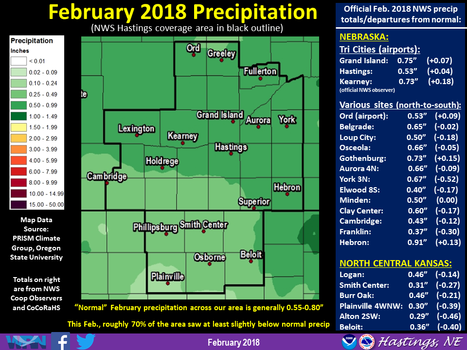
Recap of February 2018 Weather for the 30-county NWS Hastings Coverage Area:
|
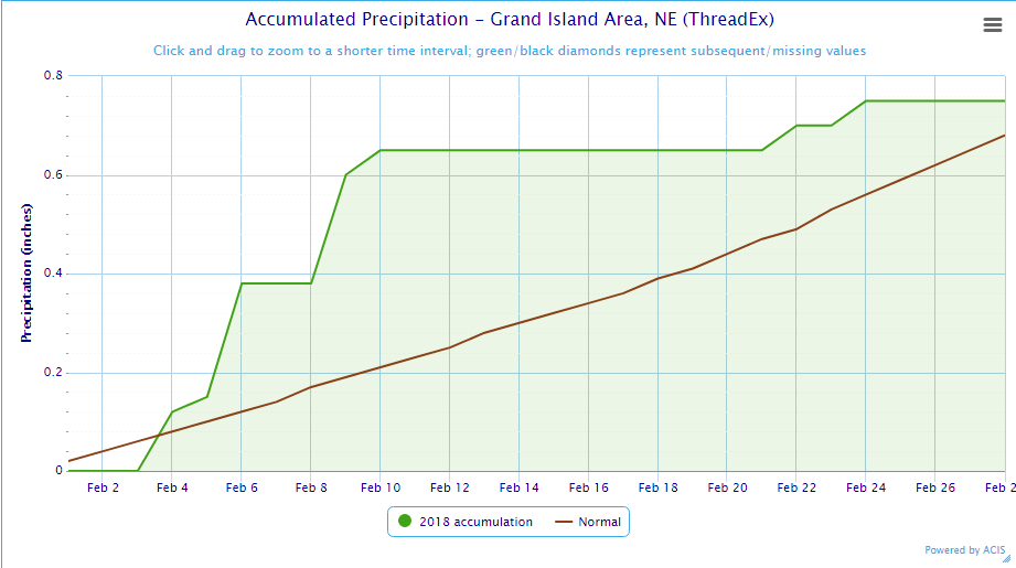
Grand Island & Hastings Details (Including 12-Month History):
 |
| Detailed February 2018 info for Grand Island/Hastings (Click to enlarge) |
 |
 |
| Grand Island Precipitation Summary: The green line indicates cumulative observed precipitation for February 2018.The brown line indicates "normal" February precipitation based on 30-year data from 1981-2010. (click to enlarge) | Hastings Precipitation Summary: The green line indicates cumulative observed precipitation for February 2018. The brown line indicates "normal" February precipitation based on 30-year data from 1981-2010. (click to enlarge) |
| Grand Island (Regional Airport ASOS) - March 2017 - Feb. 2018 | ||||||||||||
| Mar. | Apr. | May | June | July | Aug. | Sep. | Oct. | Nov. | Dec. | Jan. | Feb. | |
| Average High (F) | 54.4 | 63.1 | 72.7 | 87.5 | 88.9 | 81.3 | 80.5 | 65.2 | 53.4 | 37.3 | 34.0 | 33.6 |
| Average Low (F) | 30.0 | 39.2 | 49.6 | 61.2 | 66.6 | 58.9 | 55.0 | 40.2 | 28.7 | 16.0 | 13.5 | 12.5 |
| Average Temperature (F) | 42.2 | 51.1 | 60.3 | 74.4 | 77.8 | 70.1 | 67.8 | 52.7 | 41.1 | 26.6 | 23.7 | 23.1 |
| Departure From Normal | +2.8 | +0.5 | -0.9 | +3.1 | +1.6 | -3.9 | +2.7 | +0.5 | +3.0 | -0.1 | -1.4 | -6.0 |
| Precipitation (in) | 0.81 | 2.64 | 5.28 | 2.10 | 3.05 | 6.19 | 2.68 | 5.36 | 0.51 | 0.45 | 1.08 | 0.75 |
| Departure From Normal | -0.99 | +0.11 | +0.87 | -2.20 | -0.35 | +3.07 | +0.45 | +3.50 | -0.66 | -0.18 | +0.55 | +0.07 |
| Snowfall (in) | 1.2 | T | 0.3 | 0.0 | 0.0 | 0.0 | 0.0 | 0.9 | 0.2 | 7.2 | 10.2 | 10.6 |
| Departure From Normal | -4.2 | -1.5 | +0.3 | 0.0 | 0.0 | 0.0 | -0.1 | -0.1 | -2.9 | +2.1 | +3.7 | +4.3 |
| Hastings (Municipal Airport ASOS) - March 2017 - Feb. 2018 | ||||||||||||
| Mar. | Apr. | May | June | July | Aug. | Sep. | Oct. | Nov. | Dec. | Jan. | Feb. | |
| Average High (F) | 55.4 | 63.4 | 72.8 | 86.3 | 88.9 | 81.7 | 81.2 | 64.9 | 53.1 | 37.9 | 35.3 | 34.3 |
| Average Low (F) | 31.3 | 40.7 | 49.5 | 62.1 | 67.6 | 59.8 | 55.9 | 40.8 | 28.6 | 15.9 | 14.3 | 12.4 |
| Average Temperature (F) | 43.4 | 52.1 | 61.1 | 74.2 | 78.2 | 70.7 | 68.6 | 52.9 | 40.9 | 26.9 | 24.8 | 23.4 |
| Departure From Normal | +3.5 | +1.4 | -0.2 | +2.4 | +1.1 | -3.6 | +3.0 | +0.3 | +2.2 | -0.7 | -1.2 | -6.5 |
| Precipitation (in) | 1.08 | 3.24 | 6.42 | 1.79 | 4.71 | 5.10 | 2.18 | 4.69 | 0.08 | 0.28 | 0.49 | 0.53 |
| Departure From Normal | -0.71 | +0.68 | +1.85 | -2.01 | +0.97 | +1.80 | -0.38 | +2.70 | -1.21 | -0.33 | +0.08 | +0.04 |
| Snowfall (in) | 1.2 | 0.2 | 0.6 | 0.0 | 0.0 | 0.0 | 0.0 | 0.2 | 0.0 | 5.8 | 5.9 | 8.0 |
| Departure From Normal | -4.0 | -1.0 | +0.6 | 0.0 | 0.0 | 0.0 | -0.2 | -1.0 | -2.6 | -0.3 | -0.1 | +1.5 |
Kearney - 12 Month Climate History:
All data here is from the official NWS observer at Kearney airport, with 24-hour observations taken around 7 a.m. ** PLEASE NOTE: This official Kearney data often differs at least slightly from the unofficial data recorded by the automated airport system (KEAR) **
| Kearney Airport (Coop Observer) - March 2017 - Feb. 2018 | ||||||||||||
| Mar. | Apr. | May | June | July | Aug. | Sep. | Oct. | Nov. | Dec. | Jan. | Feb. | |
| Average High (F) | 54.6 | 62.5 | 70.2 | 86.6 | 88.1 | 81.2 | 80.7 | 65.9 | 52.3 | 38.7 | 32.2 | 32.9 |
| Average Low (F) | 28.6 | 38.8 | 45.9 | 59.7 | 64.8 | 56.9 | 52.6 | 40.0 | 26.8 | 15.5 | 11.1 | 10.6 |
| Average Temperature (F) | 41.6 | 50.7 | 58.1 | 73.2 | 76.5 | 69.1 | 66.6 | 53.0 | 39.6 | 27.1 | 21.6 | 21.7 |
| Departure From Normal | +3.9 | +2.0 | -1.4 | +3.4 | +1.8 | -3.5 | +3.1 | +2.1 | +2.6 | +1.2 | -3.0 | -6.4 |
| Precipitation (in) | 1.63 | 1.87 | 6.03 | 1.93 | 3.66 | 3.65 | 2.19 | 2.83 | 0.34 | 0.21 | 0.96 | 0.73 |
| Departure From Normal (in) | -0.16 | -0.36 | +1.85 | -2.00 | +0.38 | +0.57 | +0.12 | +0.79 | -0.68 | -0.36 | +0.47 | +0.18 |
| Snowfall (in) | 0.7 | T | 1.6 | 0.0 | 0.0 | 0.0 | 0.0 | 0.0 | 0.4 | 4.3 | 6.8 | 9.2 |
| Departure From Normal (in) | -3.9 | -1.8 | +1.6 | 0.0 | 0.0 | 0.0 | -0.2 | -0.7 | -2.7 | +0.8 | +2.4 | +4.1 |
Ord - 12 Month Climate History:
Winter precipitation totals often include NWS Cooperative Observer data due to the automated airport equipment under-measuring snowfall liquid equivalent.
| Ord (Evelyn Sharp Field ASOS) - March 2017 - Feb. 2018 | ||||||||||||
| Mar. | Apr. | May | June | July | Aug. | Sep. | Oct. | Nov. | Dec. | Jan. | Feb. | |
| Average High (F) | 53.7 | 61.7 | 69.7 | 86.3 | 90.3 | 81.4 | 78.0 | 63.7 | 53.4 | 36.6 | 34.3 | 31.2 |
| Average Low (F) | 28.7 | 37.9 | 44.1 | 56.9 | 64.1 | 56.3 | 51.2 | 36.1 | 24.3 | 14.1 | 10.2 | 9.0 |
| Average Temperature (F) | 41.2 | 49.8 | 56.9 | 71.6 | 77.2 | 68.8 | 64.6 | 49.9 | 38.9 | 25.3 | 22.2 | 20.1 |
| Departure From Normal | +3.5 | +1.0 | -2.4 | +2.4 | +2.8 | -4.2 | +1.0 | +0.3 | +2.6 | +0.4 | -2.4 | -7.7 |
| Precipitation (in) | 1.83 | 4.25 | 3.10 | 0.59 | 2.53 | 5.93 | 2.89 | 5.37 | 0.21 | 0.43 | 0.83 | 0.53 |
| Departure From Normal (in) | +0.38 | +1.66 | -0.71 | -3.53 | -0.44 | +2.77 | +0.45 | +3.44 | -0.86 | -0.16 | +0.46 | +0.09 |
| Snowfall (in) | 1.9 | 1.0 | 6.0 | 0.0 | 0.0 | 0.0 | 0.0 | 0.0 | 2.0 | 5.3 | 12.4 | 8.6 |
| Departure From Normal (in) | -4.0 | -1.5 | +6.0 | 0.0 | 0.0 | 0.0 | 0.0 | -1.1 | -3.3 | -2.1 | +5.6 | +2.6 |
Smith Center, KS - 12 Month Climate History:
All data is from the official NWS observer, with 24-hour observations taken around 7 a.m. As a result, data may vary slightly from true "Calendar Day" totals.
| Smith Center KS (NWS Coop Observer) - March 2017 - Feb. 2018 | |||||||||||||
| Feb. | Mar. | Apr. | May | June | July | Aug. | Sep. | Oct. | Nov. | Dec. | Jan. | Feb. | |
| Average High (F) | 53.4 | 58.5 | 65.4 | 73.9 | 89.8 | 95.2 | 86.4 | 85.6 | 70.5 | 55.9 | 43.6 | 39.1 | 39.4 |
| Average Low (F) | 24.2 | 30.2 | 40.0 | 46.8 | 60.9 | 66.7 | 59.9 | 56.0 | 40.1 | 28.5 | 17.6 | 12.6 | 13.5 |
| Average Temperature (F) | 38.8 | 44.4 | 52.7 | 60.4 | 75.4 | 80.9 | 73.1 | 70.8 | 55.7 | 42.2 | 30.6 | 25.9 | 26.4 |
| Departure From Normal | +6.8 | +2.8 | +0.2 | -3.3 | +1.4 | +1.2 | -4.1 | +2.6 | +0.9 | +1.8 | +1.8 | -1.8 | -5.6 |
| Precipitation (in) | 0.27 | 1.26 | 3.32 | 7.03 | 1.31 | 3.26 | 2.05 | 2.67 | 1.36 | 0.09 | 0.11 | 0.32 | 0.31 |
| Departure From Normal (in) | -0.31 | -0.61 | +1.05 | +3.11 | -2.30 | -0.61 | -1.25 | +0.63 | -0.52 | -1.13 | -0.55 | -0.17 | -0.27 |
| Snowfall (in) | 1.8 | 0.2 | 0.0 | 0.0 | 0.0 | 0.0 | 0.0 | 0.0 | 0.0 | 0.2 | 2.0 | 3.5 | 7.6 |
| Departure From Normal (in) | -2.3 | -2.4 | -0.6 | 0.0 | 0.0 | 0.0 | 0.0 | -0.2 | -0.4 | -1.6 | -1.2 | -0.2 | +3.5 |
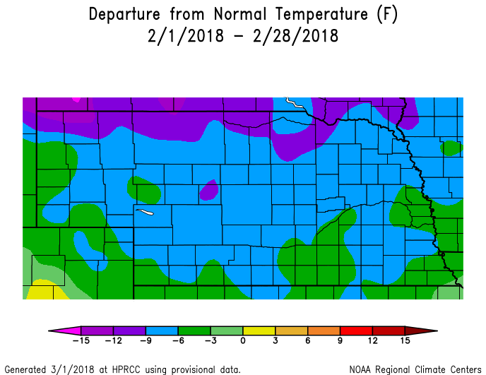
Temperature & Precipitation Departure From Normal Maps:
These images depict February 2018 monthly temperature departure from normal & precipitation percent-of-normal for both Nebraska & Kansas. Images are courtesy of the High Plains Regional Climate Center (HPRCC). Please note: These maps occasionally contain "bullseyes" of errant data. For precipitation, you can also generate departure from normal/percent-of-normal maps using the NWS AHPS page
 |
 |
 |
 |
| Departure from Normal Temperature - NE (left) & KS (right) | Percent of Normal Precipitation - NE (left) & KS (right) | ||
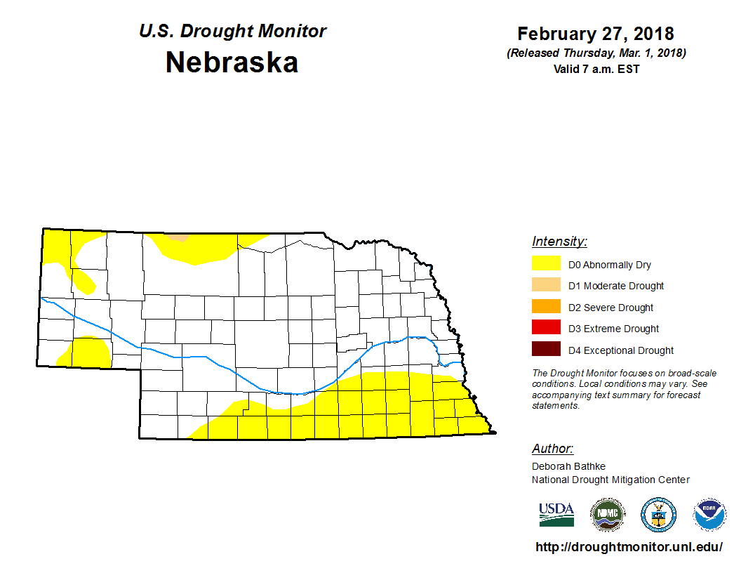
Drought:
The following drought images, current as of February 27, 2018, are courtesy of the U.S. Drought Monitor
Brief summary of changes during February across the NWS Hastings coverage area:
Although there were no "major" changes in drought categories over the course of the month across the NWS Hastings coverage area, parts of the area improved by one category while others degraded one category. More specifically, roughly half of the area remained under long-lasting Abnormally Dry (category D0) at month's end, including southern portions of south central Nebraska along with far north central Kansas. On a positive note, near-to-above normal monthly precipitation resulted in continued improvement in several northern and west-central counties, with most areas along and especially north of the Platte River becoming void of all drought categories whatsoever. On the opposite, drier end of things, there was a slight northward expansion of Moderate Drought (D1) into southern portions of north central Kansas, now encompassing most of Mitchell and Osborne counties, along with southeastern Rooks County.
 |
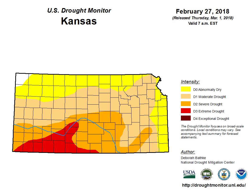 |
| Drought Monitor for Nebraska (left) & Kansas (right). Valid as of February 27, 2018 (click to enlarge) | |
Monthly Extremes for the NWS Hastings Coverage Area:
...A FEW OF THE WARMEST HIGH TEMPERATURES DURING FEBRUARY 2018...
(all data from NWS cooperative observers or automated airport sites, and all actually occurred on the 27th)
78 degrees...4WNW Plainville KS
76 degrees...Beloit KS
75 degrees...Webster Dam KS
74 degrees...2SW Alton KS
...A FEW OF THE COLDEST LOW TEMPERATURES DURING FEBRUARY 2018...
(all data from NWS cooperative observers or automated airport sites, with the date indicated in parentheses)
-13 degrees...Red Cloud (7th)
-11 degrees...Ord airport (10th)
-9 degrees...Loup City (11th)
-7 degrees...Ravenna (12th) - Canaday Steam Plant/6SSE Lexington (7th)
...A FEW OF THE HIGHEST MONTHLY PRECIPITATION TOTALS DURING FEBRUARY 2018...
(all data from NWS cooperative observers and CoCoRaHS/NeRAIN observers unless indicated)
0.91"...Hebron
0.82"...St. Paul
0.77"...2W Arcadia
0.75"...Grand Island airport
0.73"...Gothenburg
...A FEW OF THE LOWEST MONTHLY PRECIPITATION TOTALS DURING FEBRUARY 2018...
(all data from NWS cooperative observers and CoCoRaHS/NeRAIN observers unless indicated)
0.14"...Phillipsburg KS
0.18"...Natoma
0.20"...Covert KS
0.22"...3W Gresham
0.23"...Osborne KS - Webster Dam KS
...A FEW OF THE HIGHEST MONTHLY SNOWFALL TOTALS DURING FEBRUARY 2018...
(all data from NWS cooperative observers unless indicated)
13.1"...3NE Shelby
12.1"...Hebron
10.6"...Grand Island
10.4"...2W Arcadia
9.8"...Osceola
 |
Media use of NWS Web News Stories is encouraged! Please acknowledge the NWS as the source of any news information accessed from this site. |
|