February 1-2, 2016: Major Winter Storm/Blizzard Strikes The Area
Event Summary
A strong upper level low pressure system emerged onto the Plains to kick off the month of February, resulting in one of the most significant winter storms to strike the NWS Hastings coverage area in several years. (Click HERE for a map of the NWS Hastings area). Legitimate blizzard conditions affected a large portion of the area, especially northwest of a Geneva, NE to Smith Center and Phillipsburg, KS line.
Precipitation came in a series of waves, with the first few dropping roughly 1-2" of snow across the western portions of the coverage area during the daytime hours on Monday, Feb. 1st. The main "show" then started near/just after midnight on Tuesday morning the 2nd, swinging northward into the area and dropping heavy snow well into the daytime hours. While the axis of heavy snow narrowed with time during the afternoon, it was evening before those locations in that heavier band started to see snow diminish. By mid-late evening on the 2nd, little other than flurries remained. Precipitation type was not straightforward early on - as far southeastern portions of the area actually started out the event with rain, as temperatures lingered in the 40s - greatly diminishing snow totals in the Mitchell County KS area.
The primary area of surface low pressure accompanying this system tracked northeast through central and eastern Kansas, into far southeastern Nebraska before departing through Iowa toward the Great Lakes/Midwest region. The strength of this surface low along with a favorable track resulted in strong north-northwesterly winds across the local area, with sustained speeds in the strongest corridor generally between 30-40 MPH, gusting to near 50 MPH at times.
The combination of falling snow with these strong winds resulted in near-zero visibility across a large portion of the local coverage area, resulting in numerous school and business closings, as well as power outages. Numerous roads across especially south central Nebraska were deemed impassible or flat-out closed. Interstate 80 stretching from North Platte to Lincoln closed on the morning of the 2nd and remained closed into Wednesday the 3rd.
Below is a loop of water vapor satellite imagery, showing the powerful upper level low pressure system moving out of the Rocky Mountians and through the Central Plains. Click for a larger version.
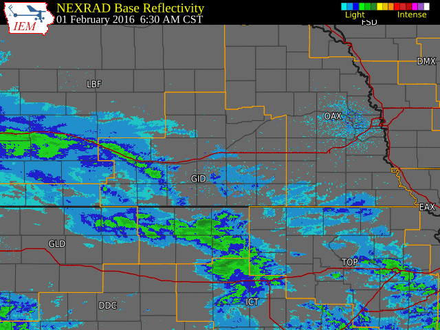
Radar Overview
The NWS radar loop below runs from 6:30 a.m. February 1st to 10:00 p.m. CST February 2nd.
The NWS Hastings coverage area is located within the orange outlined area labeled "GID".
Click on image larger version
This system had an ample amount of moisture to tap into, resulting in high (by February standards) precipitation accumulations. Many locations ended up with liquid equivalant totals (melted snow, and in the case of the far southeast, some rain) near or in excess of 1 inch. As far as snowfall totals go, a wide swath of the coverage area saw amounts near 1 foot, with a few in the 15-18" range.
Daily records for both liquid precipitation and snowfall were crushed at Grand Island and Hastings. The details follow:
At Grand Island:
- The precipitation total of 1.64" for February 2nd shattered the previous mark of 0.68" (1943).
- This was the 2nd-highest precipitation total on record for any February day, falling short of the record of 1.91", set on Feb. 8th, 1971.
- The snowfall total of 17.0" shattered the previous mark of 4.4" (1990).
- Of more significance, this was the highest daily snowfall total ever recorded in February - and was the 2nd-highest total on record for any day of the year, finishing behind only 17.8" on March 20, 2006.
- For the storm total snowfall, the 18.3" that fell during this event marked the 2nd-biggest snow event on record, trailing only the 21.6" total of March 19-21, 2006.
At Hastings:
- The precipitation total of 1.41" for Febuary 2nd shattered the previous mark of 0.70" (1919).
- This was the 2nd-highest precipitation total on record for any February day, falling short of the record of 1.53", set on February 19, 1971.
- The snowfall total of 14.3" shattered the previous mark of 8.0" (1940).
- Of more significance, this was the 2nd-highest snow total on record for any day of the year, finishing behind only 17.4" on March 20, 2006.
- For the storm total snowfall, the 15.7" that fell during this event marked the 4th-biggest snow event on record, trailing only the 20.3" total of March 19-21, 2006...17.4" of October 25-26, 1997...and 16.0" of February 3-4, 1903.
Below are tables featuring dozens of storm total snowfall (first table) and liquid precipitation (second table) totals from the NWS Hastings coverage area. All amounts are from official NWS Cooperative Observers unless otherwise noted with a *.
| Location |
Storm Total Snowfall |
| Grand Island |
18.3 |
| Wilsonville |
18.0 |
| Holdrege |
16.5 |
| 2 ENE Axtell (NTV studios) |
16.2* |
| Hastings (NWS Office) |
15.7 |
| 8 S Elwood |
15.2 |
| Beaver City |
15.0 |
| Cozad |
14.5 |
| St. Paul |
14.3 |
| 4 SW Blue Hill |
14.3 |
| Minden |
14.0 |
| Greeley |
13.6 |
| Loup City |
13.5 |
| Cambridge |
13.2 |
| 3 NE Shelby |
12.7 |
| Central City |
12.5 |
| Edison |
12.5 |
| 3 N York |
12.4 |
| Ravenna |
12.2 |
| Clay Center |
12.0 |
| Harlan County Lake |
12.0 |
| Belgrade |
12.0 |
| Ord |
12.0 |
| Superior |
12.0 |
| Phillipsburg, KS |
12.0 |
| 4 N Aurora |
11.9 |
| Osceola |
11.5 |
| 3 W Gresham |
11.5 |
| Franklin |
11.5 |
| Kearney (airport) |
11.0 |
| Arcadia |
11.0 |
| Naponee |
10.0 |
| 6 SSE Lexington (Canaday Plant) |
10.0 |
| Miller |
10.0 |
| Lebanon, KS |
10.0 |
| Burr Oak, KS |
9.5 |
| Smith Center, KS |
8.6 |
| 4 S Shickley |
8.5 |
| 4 WNW Plainville, KS |
8.4 |
| Geneva |
8.0 |
| Natoma, KS |
8.0 |
| Bruning |
8.0 |
| 6 ESE Clay Center |
6.5 |
| Belgrade |
6.0 |
| Hubbell |
6.0 |
| Jewell, KS |
5.2 |
| Ionia, KS |
5.0 |
| 2 SW Alton, KS |
5.0 |
| Hebron |
4.7 |
| Cawker City, KS |
3.0 |
| Beloit, KS |
0.5 |
| Location |
Liquid Equivalent Total |
| Wilsonville |
1.82 |
| Grand Island |
1.81 |
| Holdrege |
1.58 |
| Hastings (NWS Office) |
1.55 |
| Central City |
1.53 |
| Phillipsburg |
1.50 |
| Beaver City |
1.36 |
| 8 S Elwood |
1.35 |
| St. Paul |
1.35 |
| Superior |
1.31 |
| Franklin |
1.30 |
| 4 SW Blue Hill |
1.25 |
| Minden |
1.22 |
| York 3N |
1.21 |
| 4 S Shickley |
1.20 |
| Clay Center |
1.10 |
| Ravenna |
1.09 |
| Lebanon, KS |
1.07 |
| Edison |
1.07 |
| Oxford 6 NNW |
1.05 |
| Loup City |
1.00 |
| Cambridge |
0.99 |
| Burr Oak,KS |
0.98 |
| Kearney (airport) |
0.98 |
| Naponee |
0.98 |
| Smith Center, KS |
0.98 |
| Osceola |
0.95 |
| 3 NE Shelby |
0.93 |
| Cawker City, KS |
0.89 |
| Belgrade |
0.88 |
| Geneva |
0.86 |
| Ord |
0.82 |
| Harlan County Lake |
0.81 |
| 4 N Aurora |
0.80 |
| Natoma, KS |
0.78 |
| Miller |
0.75 |
| 6 SSE Lexington (Canaday Plant) |
0.73 |
| Hubbell |
0.73 |
| Jewell, KS |
0.73 |
| Ionia, KS |
0.72 |
| 6 ESE Clay Center |
0.70 |
| Cozad |
0.69 |
| Greeley |
0.66 |
| 3 W Gresham |
0.65 |
| 4 WNW Plainville, KS |
0.65 |
| 2 SW Alton, KS |
0.58 |
| Beloit, KS |
0.38 |

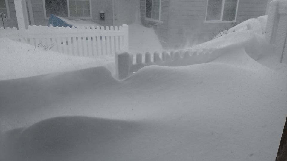
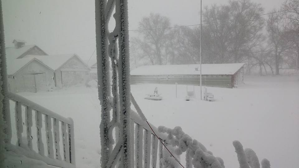
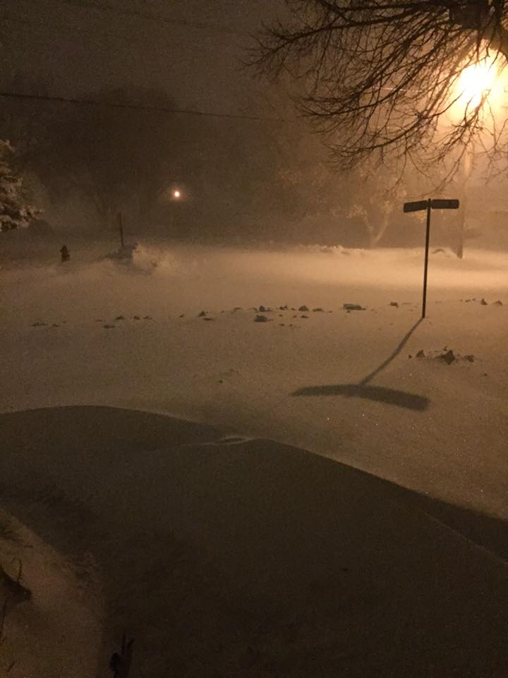
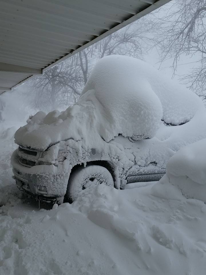
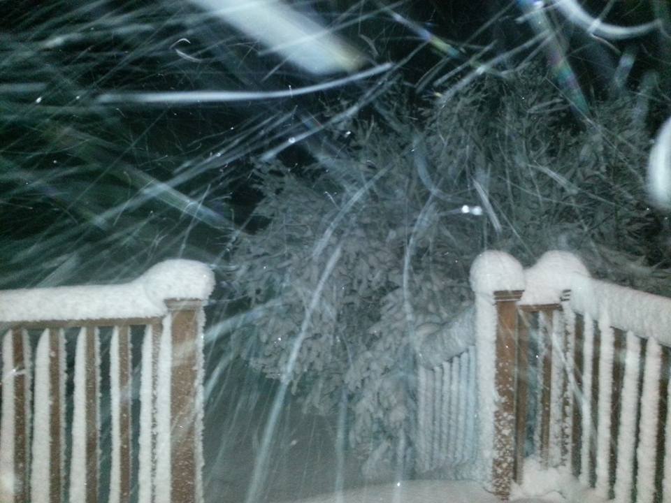
Below is a collection of just a few of the numerous photos we recieved from across the coverage area, most of which were sent to our Facebook/Twitter accounts (unfortunately, due to time and space constraints, we were not able to include all of them).
 |
 |
 |
 |
 |
| Giltner - Photo courtesy of Courtney Ott Scott. |
Ravenna - Photo courtesy of Deandra Kaslon. |
Kearney - Photo courtesy of Haley Jo. |
Near Archer - Photo courtesy of Sara Umstead. |
Near Shelby - Photo courtesy of Freddy McKinney. |
 |
 |
 |
 |
 |
| Loomis - Photo courtesy of Kalei Freeland. |
Wood River - Photo courtesy of Megan Lowe. |
Grand Island - Photo courtesy of Rosa Amigo De Robinson. |
Grand Island - Photo courtesy of Trina Lindell. |
Grand Island - Photo courtesy of Tony Graczyk. |
 |
 |
 |
 |
 |
| Wolbach - Photo courtesy of Rex Friedrichsen. |
Dannebrog - Photo courtesy of Paula Dush. |
Hastings - Photo courtesy of Amanda Schroeder. |
Hastings - Photo courtesy of Judi Carpenter. |
Central City - Photo courtesy of Teena Paup. |
 |
 |
 |
 |
 |
| Near Hendley - Photo courtesy of Darla McGahan. |
Hildreth - Photo courtesy
of Beau Johnson. |
Stamford - Photo courtesy
of Larison Jeny. |
Near Gibbon - Photo courtesy of Brandi Lea Mcharness. |
Phillips County, KS. |
 |
This page was composed by the staff at the National Weather Service in Hastings, Nebraska. |
 |