
Flash flooding threatens areas from the Tennessee Valley to the Carolinas as storms repeat along a stalled front. Monsoonal storms may trigger flooding in the Southwest. Dangerous heat expands across the Desert Southwest, Plains, mid-Mississippi Valley and Southern Tier. Critical fire weather for interior Pacific Northwest. Cooler, drier air brings brief relief to the Great Lakes and Northeast. Read More >
Brief Summary:
(see tabs below for much more, including full narrative and graphics!)
More than anything else, December 2018 was highlighted by WELL-ABOVE NORMAL precipitation (most areas 300-600% of normal!), most of which fell as rain and not snow. However, snowfall was also above-normal mainly within the northwest half of the area. Temperature-wise, it was a modestly warmer-than-average month, with most locations between 1-4º above normal. (See full narrative below for much more detail!)
NOTE: Information in this story is exclusively for the 30-county NWS Hastings Coverage Area
|
Narrative
- Precipitation (rainfall+snow liquid...see map at top of story): BY FAR the biggest story of the month was how incredibly wet it was, as most locations notched one of their Top-3 wettest months of December on record! More specifically, the majority of the area received between 2.50-4.50", or generally 300-600% of December normals! Just to name a few specific locations, it was the 2nd-wettest December on record in Grand Island and Kearney, and was THE WETTEST on record at Osceola (out of 113 years) and at Beloit KS (out of 102 years)! The month contained two significant precipitation events (one early and one late in the month), both of which featured the majority of precipitation as rain (and not snow). The first of these events technically began the evening of Nov. 30th, but with the majority of precipitation falling Dec. 1-2. While many places received at least a few inches of snow (see separate snow section below), total precipitation amounts of 1-3" were common, with the highest totals concentrated near and east of Highway 281. In the wake of this early-month soaker, the entire area then entered a 3+ week stretch of mostly-dry weather. However, the 26th-28th brought another major, slow-moving storm system. While this one ended up yielding a more significant snow storm/blizzard for mainly the northwest half of the area (see separate snow section below), once again all areas received the majority of precipitation in the form of rain before colder air arrived, with event-total precipitation amounts commonly 1.00-2.50". Per dozens of NWS/CoCoRaHS observers, a few of the highest-known December totals featured: 5.10" near Shickley, 4.97" near Davenport, 4.86" near Clay Center and 4.70" near Doniphan. On the drier (BUT still well-above normal) side of things, a few of the lower monthly totals included: 2.20" south of Elwood, 2.27" at Lexington and 2.40" near Plainville KS.
As for shorter-term/24-hour-or-less precipitation totals, a few of the highest from NWS/CoCoRaHS observers featured: 3.05" south of Shickley (reported on the 1st), 3.00" southeast of Davenport (reported on the 1st) and 2.74" at Bruning (reported on the 1st).
- Snowfall/Winter Weather (see snow map at top of story): December featured a LARGE disparity in snowfall across the area, as both of the month's "main events" targeted western/northern counties considerably more so than southern/eastern counties. Generally speaking, locations northwest of a Phillipsburg KS-Grand Island-Fullerton line saw the highest monthly amounts ranging anywhere from 6-15", while most areas southeast of that line received no more than 1-5". Per NWS/CoCoRaHS observers, a few of the highest December totals featured: 15.0" southwest of Lexington, 12.9" at Greeley, and 12.0" in Cambridge and near Scotia. Here is a brief recap of the two primary December snow events:
- 1) Dec. 1-2: Although snow totals fell short of forecasted expectations in most places, the majority of the area received 1-5", including 5.5" in Holdrege, 5.1" near Shelby and 4.9" in Kearney. Outside of the primary exceptions of Polk and Greeley counties, the overall-highest totals fell within counties west of the Highway 281 corridor.
- 2) Dec. 27-28: For mainly the northwest half of the local area, this was the biggest/most-impactful winter storm of the season-so-far, featuring a combination of heavy snow and strong north winds frequently gusting 40-50+ MPH, promoting drifting and blizzard/white-out conditions. The majority of snow fell on the 27th, impacting post-Christmas travel as Interstate 80 was eventually shut down from Grand Island westward to North Platte. As for totals, there was a sharp divide, with most places northwest of roughly an Alma-Kearney-Spalding line seeing anywhere from 4-10", while most places southeast of that line received no more than 1-3" (including Grand Island/Hastings). A few of the highest totals featured: 9" near Lexington and Scotia, 8.5" at Greeley, and 8.0" at Edison and near Cozad.
- Flooding: Although the two significant rain events of the month promoted within-bank rises on many rivers and larger streams within the area (and perhaps pushed a few smaller creeks/streams briefly out of their banks), there were no noteworthy flooding issues as a result of heavy rain. It is likely that the overall warmer-than-average temperatures and resultant lack of deep ground frost aided in keeping more noticeable flooding at bay. The ONLY Flood Advisory issued by NWS Hastings during December was on the 31st, due to a minor ice jam along a small portion of the Middle Loup River near Rockville.
- Temperatures: December broke a two-month streak of below-normal temperatures, as the majority of the area averaged 1-4º ABOVE normal. While the month started and ended on a colder note, the middle portion featured a prolonged stretch of consistently mild (but not record-breaking) readings, with most places seeing highs in the 40s/50s for a 17-day stretch between the 11th-27th. Within this overall-warmer period of weather, the outright-warmest days (and nights) concentrated between the 16th-21st. As for monthly extremes per official NWS observers/stations, most of the warmest readings occurred on either the 16th or 17th, including: 61º at Webster Dam KS and 60º at Beaver City. On the much colder side of things, the morning of the 29th featured the month's coldest readings in most areas, highlighted by lows of: -10º at Cambridge, -8º at Beaver City and -6º at Ord airport, Ravenna and near Oxford.
- Severe Thunderstorms/Tornadoes/Severe Non-Thunderstorm Winds (for official severe storm reports refer to NCEI Storm Events Database):
- # of confirmed tornadoes during December 2018: Zero (same as 2017)
- Largest known hail stone reported to NWS Hastings: None occurred
- Strongest known measured thunderstorm wind gust: None occurred
- Strongest known measured NON-thunderstorm wind gusts: Several official and unofficial stations recorded peak northerly gusts between 45-53 MPH on one or both of the following days: 1) Dec. 27 during a winter storm...2) Dec. 31 behind a strong Arctic cold front. A few of the highest official gusts during this time frame featured: 53 MPH at Ord airport and 52 MPH at Grand Island and Hastings airports.
- Notable wind damage reported to NWS Hastings (ground-truth reports): None reported
- # of Severe Thunderstorm Warnings issued by NWS Hastings: Zero (same as 2017)
- # of Tornado Warnings issued by NWS Hastings: Zero (same as 2017)
Grand Island & Hastings Details (Including 12-Month History):
 |
| Detailed December 2018 info for Grand Island/Hastings (Click to enlarge) |
 |
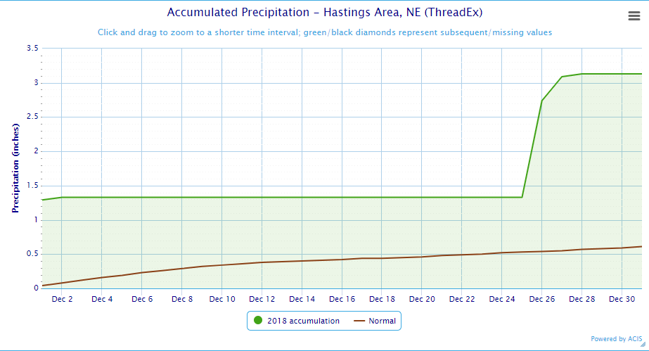 |
| Grand Island Precipitation Summary: The green line indicates cumulative observed precipitation for December 2018.The brown line indicates "normal" December precipitation based on 30-year data from 1981-2010. (click to enlarge) | Hastings Precipitation Summary: The green line indicates cumulative observed precipitation for December 2018. The brown line indicates "normal" December precipitation based on 30-year data from 1981-2010. (click to enlarge) |
| Grand Island (Regional Airport ASOS) - Jan. 2018 - Dec. 2018 | |||||||||||||
| Jan. | Feb. | Mar. | Apr. | May | June | July | Aug. | Sept. | Oct. | Nov. | Dec. | 2018 | |
| Average High (F) | 34.0 | 33.6 | 51.8 | 55.4 | 78.6 | 88.2 | 85.8 | 84.3 | 77.4 | 61.3 | 45.9 | 39.5 | |
| Average Low (F) | 13.5 | 12.5 | 28.8 | 30.8 | 55.5 | 64.8 | 64.6 | 62.5 | 57.4 | 38.1 | 24.2 | 20.2 | |
| Average Temperature (F) | 23.7 | 23.1 | 40.3 | 43.1 | 67.0 | 76.5 | 75.2 | 73.4 | 67.4 | 49.7 | 35.0 | 29.9 | 50.4 |
| Departure From Normal | -1.4 | -6.0 | +0.9 | -7.5 | +5.8 | +5.2 | -1.0 | -0.6 | +2.3 | -2.5 | -3.1 | +3.2 | -0.4 |
| Precipitation (in) | 1.08 | 0.75 | 1.26 | 1.26 | 3.98 | 4.61 | 3.58 | 2.67 | 2.49 | 2.88 | 1.69 | 3.44 | 29.69 |
| Departure From Normal | +0.55 | +0.07 | -0.54 | -1.27 | -0.43 | +0.31 | +0.18 | -0.45 | +0.26 | +1.02 | +0.52 | +2.81 | +3.03 |
| Snowfall (in) | 10.2 | 10.6 | 0.4 | 4.1 | 0.0 | 0.0 | 0.0 | 0.0 | 0.0 | 1.5 | 7.9 | 4.2 | |
| Departure From Normal | +3.7 | +4.3 | -5.0 | +2.6 | 0.0 | 0.0 | 0.0 | 0.0 | -0.1 | +0.5 | +4.8 | -0.9 | |
| Hastings (Municipal Airport ASOS) - Jan. 2018 - Dec. 2018 | ||||||||||||||
| Dec. | Jan. | Feb. | Mar. | Apr. | May | June | July | Aug. | Sept. | Oct. | Nov. | Dec. | 2018 | |
| Average High (F) | 37.9 | 35.3 | 34.3 | 52.3 | 55.6 | 78.2 | 87.0 | 85.5 | 83.3 | 76.4 | 60.9 | 46.3 | 39.9 | |
| Average Low (F) | 15.9 | 14.3 | 12.4 | 27.8 | 30.6 | 55.6 | 65.0 | 65.1 | 63.1 | 58.2 | 38.7 | 24.9 | 21.9 | |
| Average Temperature (F) | 26.9 | 24.8 | 23.4 | 40.1 | 43.1 | 66.9 | 76.0 | 75.3 | 73.2 | 67.3 | 49.8 | 35.6 | 30.9 | 50.5 |
| Departure From Normal | -0.7 | -1.2 | -6.5 | +0.2 | -7.6 | +5.6 | +4.2 | -1.8 | -1.1 | +1.7 | -2.8 | -3.1 | +3.3 | -0.8 |
| Precipitation (in) | 0.28 | 0.49 | 0.53 | 1.07 | 1.26 | 3.83 | 5.91 | 2.19 | 4.40 | 3.69 | 3.04 | 1.52 | 3.13 | 31.06 |
| Departure From Normal | -0.33 | +0.08 | +0.04 | -0.72 | -1.30 | -0.74 | +2.11 | -1.55 | +1.10 | +1.13 | +1.05 | +0.23 | +2.52 | +3.95 |
| Snowfall (in) | 5.8 | 5.9 | 8.0 | 0.3 | 6.9 | 0.0 | 0.0 | 0.0 | 0.0 | 0.0 | 1.1 | 5.5 | 4.3 | |
| Departure From Normal | -0.3 | -0.1 | +1.5 | -4.9 | +5.7 | 0.0 | 0.0 | 0.0 | 0.0 | -0.2 | +0.1 | +2.9 | -1.8 | |
Kearney - 12 Month Climate History:
All data here is from the official NWS observer at Kearney airport, with 24-hour observations taken around 7 a.m. ** PLEASE NOTE: This official Kearney data often differs slightly from the unofficial data recorded by the automated airport system (KEAR) **
| Kearney Airport (Coop Observer) - Jan. 2018 - Dec. 2018 | |||||||||||||
| Jan. | Feb. | Mar. | Apr. | May | June | July | Aug. | Sept. | Oct. | Nov. | Dec. | 2018 | |
| Average High (F) | 32.2 | 32.9 | 51.9 | 53.8 | 75.9 | 86.6 | 84.6 | 82.3 | 77.6 | 59.0 | 45.2 | 37.5 | |
| Average Low (F) | 11.1 | 10.6 | 26.1 | 28.6 | 52.7 | 62.9 | 63.0 | 59.9 | 55.8 | 35.7 | 22.6 | 18.4 | |
| Average Temperature (F) | 21.6 | 21.7 | 39.0 | 41.2 | 64.3 | 74.7 | 73.8 | 71.1 | 66.7 | 47.3 | 33.9 | 28.0 | 48.6 |
| Departure From Normal | -3.0 | -6.4 | +1.3 | -7.5 | +4.8 | +4.9 | -0.9 | -1.5 | +3.2 | -3.6 | -3.1 | +2.1 | -0.8 |
| Precipitation (in) | 0.96 | 0.73 | 1.05 | 2.03 | 5.56 | 2.87 | 6.07 | 2.05 | 1.85 | 3.50 | 0.85 | 3.49 | 31.01 |
| Departure From Normal (in) | +0.47 | +0.18 | -0.74 | -0.20 | +1.38 | -1.06 | +2.79 | -1.03 | -0.22 | +1.46 | -0.17 | +2.92 | +5.78 |
| Snowfall (in) | 6.8 | 9.2 | 0.7 | 9.7 | 0.0 | 0.0 | 0.0 | 0.0 | 0.0 | 1.4 | 5.7 | 8.7 | |
| Departure From Normal (in) | +2.4 | +4.1 | -3.9 | +7.9 | 0.0 | 0.0 | 0.0 | 0.0 | -0.2 | +0.7 | +2.6 | +5.2 | |
Ord - 12 Month Climate History:
All snowfall data is from the NWS Cooperative Observer in town. In addition, winter precipitation totals often include Cooperative Observer data given that the automated airport equipment is not designed to accurately melt snowfall liquid equivalent (in most cases).
| Ord (Evelyn Sharp Field ASOS) - Jan. 2018 - Dec. 2018 | |||||||||||||
| Jan. | Feb. | Mar. | Apr. | May | June | July | Aug. | Sept. | Oct. | Nov. | Dec. | 2018 | |
| Average High (F) | 34.3 | 31.2 | 49.9 | 54.1 | 75.4 | 84.0 | 84.0 | 82.2 | 75.4 | 59.5 | 45.3 | 38.6 | |
| Average Low (F) | 10.2 | 9.0 | 25.5 | 27.3 | 51.8 | 60.8 | 62.0 | 59.1 | 54.5 | 33.6 | 20.2 | 14.5 | |
| Average Temperature (F) | 22.2 | 20.1 | 37.7 | 40.7 | 63.6 | 72.4 | 73.0 | 70.6 | 65.0 | 46.5 | 32.8 | 26.6 | 47.6 |
| Departure From Normal | -2.4 | -7.7 | 0.0 | -8.1 | +4.3 | +3.2 | -1.4 | -2.4 | +1.4 | -3.1 | -3.5 | +1.7 | -1.5 |
| Precipitation (in) | 0.83 | 0.53 | 0.62 | 1.47 | 4.38 | 7.57 | 5.84 | 2.57 | 1.53 | 2.47 | 0.91 | 3.09 | 31.81 |
| Departure From Normal (in) | +0.46 | +0.09 | -0.83 | -1.12 | +0.57 | +3.45 | +2.87 | -0.59 | -0.91 | +0.54 | -0.16 | +2.50 | +6.87 |
| Snowfall (in) | 12.4 | 8.6 | 1.1 | 10.1 | 0.0 | 0.0 | 0.0 | 0.0 | 0.0 | 0.3 | 3.8 | 10.5 | |
| Departure From Normal (in) | +5.6 | +2.6 | -4.8 | +7.6 | 0.0 | 0.0 | 0.0 | 0.0 | 0.0 | -0.8 | -1.5 | +3.1 | |
Smith Center, KS - 12 Month Climate History:
All data is from the official NWS observer, with 24-hour observations taken around 7 a.m. As a result, data may vary slightly from true "Calendar Day".
| Smith Center KS (NWS Coop Observer) - Jan. 2018 - Dec. 2018 | |||||||||||||
| Jan. | Feb. | Mar. | Apr. | May | June | July | Aug. | Sept. | Oct. | Nov. | Dec. | 2018 | |
| Average High (F) | 39.1 | 39.4 | 57.8 | 58.4 | 82.7 | 92.2 | 90.7 | 86.9 | 80.9 | 62.5 | 48.6 | 41.1 | |
| Average Low (F) | 12.6 | 13.5 | 27.9 | 29.6 | 55.6 | 63.9 | 65.5 | 62.5 | 57.6 | 38.5 | 24.4 | 20.3 | |
| Average Temperature (F) | 25.9 | 26.4 | 42.8 | 44.0 | 69.1 | 78.0 | 78.1 | 74.7 | 69.3 | 50.5 | 36.5 | 30.7 | 52.2 |
| Departure From Normal | -1.8 | -5.6 | +1.2 | -8.5 | +5.4 | +4.0 | -1.6 | -2.5 | +1.1 | -4.3 | -3.9 | +1.9 | -1.2 |
| Precipitation (in) | 0.32 | 0.31 | 1.05 | 0.91 | 2.62 | 6.33 | 3.98 | 3.25 | 3.88 | 4.61 | 0.62 | 3.61 | 31.04 |
| Departure From Normal (in) | -0.17 | -0.27 | -0.82 | -1.36 | -1.30 | +2.72 | +0.11 | -0.05 | +1.84 | +2.73 | -0.60 | +2.95 | +5.33 |
| Snowfall (in) | 3.5 | 7.6 | T | 2.0 | 0.0 | 0.0 | 0.0 | 0.0 | 0.0 | 1.2 | 5.8 | 2.4 | |
| Departure From Normal (in) | -0.2 | +3.5 | -2.6 | +1.4 | 0.0 | 0.0 | 0.0 | 0.0 | -0.2 | +0.8 | +4.0 | -0.8 | |
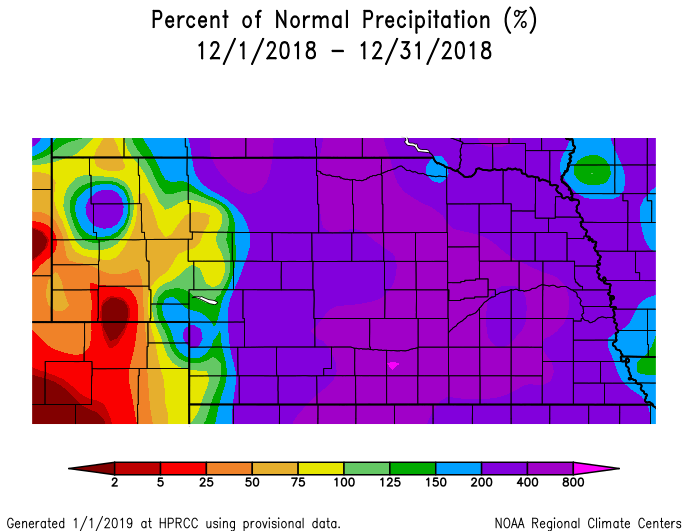
Temperature & Precipitation Departure From Normal Maps:
These images depict December 2018 monthly temperature departure from normal & precipitation percent-of-normal for both Nebraska & Kansas. Images are courtesy of the High Plains Regional Climate Center (HPRCC). Please note: These maps occasionally contain "bullseyes" of errant data. For precipitation, you can also generate departure from normal/percent-of-normal maps using the NWS AHPS page, or view local-area images generated each day by NWS Hastings.
 |
 |
 |
 |
| Departure from Normal Temperature - NE (left) & KS (right) | Percent of Normal Precipitation - NE (left) & KS (right) | ||
Drought:
The following drought images, current as of January 1, 2019, are courtesy of the U.S. Drought Monitor
Summary of changes during December 2018 across the NWS Hastings coverage area:
Given the INCREDIBLY WET conditions (by December standards) observed across the entire area, it should come as no surprise that the ENTIRE NWS Hastings coverage area remained void of all drought categories during the month.
 |
 |
| Drought Monitor for Nebraska (left) & Kansas (right). Valid as of January 1, 2019 (click to enlarge) | |
December 2018 Extremes for the NWS Hastings Coverage Area:
...A FEW OF THE WARMEST HIGH TEMPERATURES DURING DECEMBER 2018...
(all data from NWS cooperative observers or automated airport sites, with the date it actually occurred indicated in parentheses)
61 degrees...Webster Dam KS (17th)
60 degrees...Beaver City (17th, 18th)
59 degrees...Edison (17th) - Cambridge (17th)
58 degrees...Loup City (17th) - Kirwin Dam KS (17th)
57 degrees...Beloit KS (17th) - Glen Elder Lake KS (17th) - Smith Center KS (17th) - Franklin (17th) - Oxford 6NNW (17th)
...A FEW OF THE COLDEST LOW TEMPERATURES DURING DECEMBER 2018...
(all data from NWS cooperative observers or automated airport sites, with the date it actually occurred indicated in parentheses)
-10 degrees...Cambridge (29th)
-8 degrees...Beaver City (29th)
-6 degrees...Ord airport (29th) - Oxford 6NNW (29th) - Ravenna (29th)
-4 degrees...Loup City (29th) - Greeley (29th) - Genoa 2W (29th)
-2 degrees...Gothenburg (29th) - Edison (29th)
...A FEW OF THE HIGHEST MONTHLY PRECIPITATION TOTALS DURING DECEMBER 2018...
(all data from NWS cooperative observers and CoCoRaHS/NeRAIN observers unless indicated)
PLEASE NOTE: Most of these totals include rain that fell on the evening of Nov. 30th
5.10"...Shickley (4S)
4.97"...Davenport (6SE)
4.86"...Clay Center 5SSE
4.70"...Doniphan 2W
4.69"...Bruning
4.63"...Minden
4.52"...St. Paul
4.45"...Clay Center
4.39"...Superior (6NE)
4.38"...Holdrege
...A FEW OF THE LOWEST MONTHLY PRECIPITATION TOTALS DURING DECEMBER 2018...
(all data from NWS cooperative observers and CoCoRaHS/NeRAIN observers unless indicated)
2.20"...Elwood (8S)
2.27"...Lexington (1E)
2.40"...Plainville KS (4WNW)
2.61"...Oxford (6NNW)
2.67"...Gothenburg
2.75"...Cozad (4S) - Cambridge
2.94"...Shelby (3NE)
2.95"...Logan
...A FEW OF THE HIGHEST MONTHLY SNOWFALL TOTALS DURING DECEMBER 2018...
(all data from NWS cooperative observers and CoCoRaHS/NeRAIN observers)
15.0"...Lexington (6SW)
12.9"...Greeley
12.0"...Scotia (4E) - Cambridge
11.9"...Loup City
11.8"...Ord (9NW)
11.5"...Beaver City (6S)
11.4"...Cozad (4S)
11.0"...Wilsonville
10.5"...Ord (in town) - Holdrege
10.0"...Beaver City
 |
Media use of NWS Web News Stories is encouraged! Please acknowledge the NWS as the source of any news information accessed from this site. |
|


