
Showers and thunderstorms with locally heavy rain is possible across the Ohio Valley southwest into the Southern Plains. Modest atmospheric river activity will bring unsettled weather to the Pacific Northwest and northern Rockies going through early this week, including heavy rains for the coastal ranges and accumulating snow for the higher elevations. Read More >
 |
 |
|

Click to Enlarge Photo
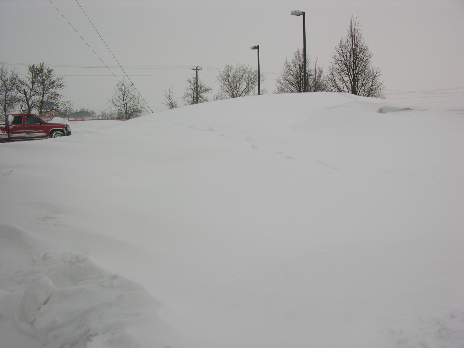
The Christmas Blizzard of 2009 will be one blizzard which won't soon be forgotten and will draw memories of raging blizzards of years past. For 18 to 24 hours, a large part of south central Nebraska and extreme northern Kansas was blasted with 30 to 60 mph winds, visibilities less than 1/2 mile and frequent "white-out" conditions. Winds dropped off dramatically by dawn Saturday, December 26th, although still gusted to 35 mph.
A total of 7.8 inches of snow fell at the Central Nebraska Regional Airport at Grand Island on Christmas Day. That broke the previous record of 3.0 inches of snow set back in 1941. So, Christmas 2009 goes down as the "snowiest" Christmas on record for Grand Island. The snow melted down to 0.51 inches of water, which was also a new record. The old record for liquid precipitation was 0.20 inches in 1941.
Hastings joined the record club as well, and measured 9.2 inches of the National Weather Service Office north of town. That broke the previous record of 9.0 inches of snow back in 1945. A total of 0.58" of liquid equivalent precipitation was measured. However, that was not enough to break a record.
| Christmas 2009 Snowfall | Previous Record | Christmas 2009 Precipitation | Previous Record | |
| Grand Island | 7.8 inches | 3.0 inches in 1941 | 0.51" | 0.20" in 1941 |
| Hastings | 9.2 inches | 9.0 inches in 1945 | 0.58" | 1.00" in 1945 (record still stands) |
Listed below are several snowfall reports from NWS Cooperative Observers across south central Nebraska and north central Kansas. The reports are ranked from top to bottom based on the 5-day storm total snowfall from Dec. 23-27.
Below the table is a map depicting approximate 5-day storm total snowfall across the 30-county NWS Hastings County Warning Area. Please note that values on this map are not necessarily "exact" measured values at a particular point due to computer-generated "smoothing" between available data. In addition, it goes without saying that this snow was very challenging to measure given extensive blowing and drifting.
| Dec. 23 | Dec. 24 | Dec. 25 | Dec. 26-27 | 5-Day Storm Total |
Total December Snowfall (through 12/27) |
|
| Osceola |
Trace |
3.7" |
4.0" |
8.0" |
15.7 inches |
30.2 inches |
| Shelby (3 miles NE) | Trace | 3.8" | 5.8" | 6.1" | 15.7 inches | |
| Central City | 4.0" | 0.5" | 5.2" | 3.8" | 13.5 inches | 26.0 inches |
| Grand Island |
3.1" |
Trace |
7.8" |
1.3" |
12.2 inches |
25.5 inches |
| Hastings NWS Office |
3.5" |
0.2" |
9.2" |
1.4" |
14.3 inches |
29.3 inches |
| Wood River |
3.5" |
Trace |
7.0" |
1.5" |
12.0 inches |
23.3 inches |
| Fullerton | Trace | 4.0" | 2.0" | 6.0" | 12.0 inches | 22.0 inches |
| Bruning |
Trace |
3.0" |
5.0" |
3.0" |
11.0 inches |
21.1 inches |
| Greeley | Trace | 4.0" | 1.0" | 4.0" | 9.0 inches | 22.0 inches |
| Geneva | 1.0" | None | 3.0" | 4.0" | 8.0 inches | 17.0 inches |
| Fairmont |
2.0" |
4.0" |
2.0" |
0.5" |
8.5 inches |
20.0 inches |
| Oxford (6 miles NNW) |
1.9" |
5.5" |
Trace |
0.4" |
7.8 inches |
16.5 inches |
| Clay Center (6 miles ESE) |
1.0" |
2.0" |
3.0" |
1.0" |
7.0 inches |
19.0 inches |
| Ord | 2.5" | 4.5" | 7.0 inches | |||
| Wolbach | None | 2.6" | 1.2" | 2.9" | 6.7 inches | 16.3 inches |
| Loup City |
3.5" |
Trace |
2.0" |
1.0" |
6.5 inches |
17.5 inches |
| Phillipsburg, KS | 2.0" | 2.0" | Trace | 2.0" | 6.0 inches | 11.6 inches |
| Franklin | Trace | 3.0" | None | 2.0" | 5.0 inches | |
| Edison | 0.5" | 4.0" | None | 1.0" | 5.5 inches | 12.0 inches |
| Plainville, KS (4 WNW) | 2.0" | 0.5" | None | 1.5" | 4.0 inches | 13.3 inches |
| Superior (4 miles E) |
0.6" |
1.1" |
1.3" |
0.4" |
3.4 inches |
17.5 inches |
| Elwood (8 miles S) | 1.0" | 2.0" | None | Trace | 3.0 inches | 11.0 inches |
| Miller | 2.0" | Trace | 1.0" | 3.0 inches | ||
| Burr Oak, KS |
0.8" |
Trace |
2.0" |
0.2" |
3.0 inches |
16.5 inches |
| Smith Center, KS |
1.0" |
None |
0.8" |
None |
1.8 inches |
7.8 inches |
| Beloit, KS | None | None | Trace | 2.0" | 2.0 inches | 17.3 inches |
| Alton, KS | 1.0" | Trace | None | Trace | 1.0 inches | 11.0 inches |
Approximate 5-Day Total Snowfall Based On Data Listed Above (Dec. 23 - Dec. 27)

The graphic below depicts total snow depth across the NWS Hastings County Warning Area, as of the morning of Dec. 27th. Note the extensive area of 10-15 inch snow depth extending north and east from the Grand Island and Hastings areas. A few Cooperative Observer sites in Polk County even reported snow depths in excess of 20 inches, including 23 inches at both Osceola and Shelby (3 miles NE).
Total Snow Depth As Of 7 AM, Dec. 27th

Of course, its the wind that makes a blizzard, not the snow. The strongest winds occurred during the daylight hours on Christmas Day and into the early evening. Sustained winds were near 40 mph at times with gusts to 60 mph. Here is a look at the strongest winds recorded with the storm:
| Hastings Airport | 58 mph |
| Aurora Airport | 57 mph |
| Grand Island Airport | 54 mph |
| Ord Airport | 53 mph |
| Holdrege Airport | 51 mph |
| Lexington Airport | 50 mph |
| Kearney Airport | 46 mph |
 |
 |
 |
 |
 |
 |
 |
 |
The final image below depicts water vapor satellite imagery as of 1215 PM CST on Christmas day, during the height of the blizzard across much of south central Nebraska. The darker colored areas indicate locations where dry air is prevalent in the atmosphere, while light colored (white) areas indicate areas of moisture. Note the expansive counter-clockwise swirl centered over Iowa, which is the primary low pressure system responsible for the blizzard conditions.

|
|
This page was composed by the staff at the National Weather Service in Hastings, Nebraska. |
 |


