National Weather Service United States Department of Commerce

If you have any photos you would like to share, please feel free to post them to our Facebook or Twitter pages, or send them to our webmaster e-mail account at: w-gid.webmaster@noaa.gov. Please let us know where the photo was taken, and at least an approximate time. Thanks!


May 6th, 2015 

Severe Storms Produce Several Tornadoes and Significant Flooding Within The Local Area


To the right is a NWS radar loop from 1:35 p.m.  on Wednesday, May 6th  to 12:35 a.m. on Thursday, May 7th.

The NWS Hastings coverage area is located within the orange outlined area labeled "GID".
(Click Radar Loop To Enlarge)

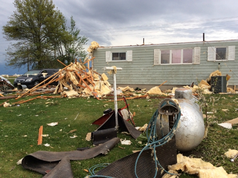
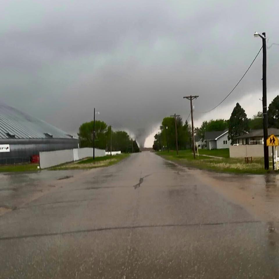
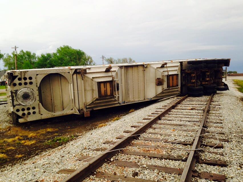
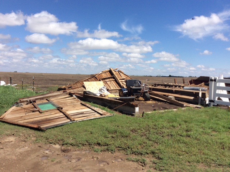
Event Summary:

The afternoon and evening hours of Wednesday, May 6, 2015, featured a significant severe weather outbreak within primarily the southeast half of the NWS Hastings coverage area. In addition to several tornadoes, a narrow corridor of record-breaking rainfall also resulted in widespread flooding (see separate rainfall/flooding section below). NOTE: As of this writing, surveys of tornado damage trackes/intensity are still ongoing, and this information will gradually be added to the separate tornado section below over the next few days. In the meantime please see this statement for a very general rundown of locations/timing of tornadic activity.

Breaking down event-timing, the majority of tornadoes and severe weather occurred between 330-630 PM CDT, as several rotating supercell storms developed and tracked northeast at generally 25-40 MPH. Some of these storms were "high precipitation (HP)" supercells that featured rain-wrapped tornadoes which were hard to see even at close range. Although the majority of tornadoes within the local area impacted Jewell County KS and Nuckolls/Thayer counties in Nebraska, other isolated severe storms formed northwest of the "main zone", including one that produced an EF-1 tornado that struck Roseland in Adams County. Although reports of tornadoes diminished as the evening wore on, radar continued to indicate several signatures of rotation and large hail well into the evening hours before things calmed down. In total, NWS Hastings issued 27 Tornado Warnings and 22 Severe Thunderstorm Warnings between 241-1052 PM CDT.

As for the meteorology behind this event, tornadic storms were sparked by the combination of a surface low pressure system setting up over western parts of the Central Plains, along with an upper level disturbance passing northeastward overhead. This created a moist, southeasterly flow into the area, along with appreciable low level wind shear (a key ingredient to the formation of strong tornadoes). Although the number of tornadoes and the magnitude of flooding within the area likely "exceeded expectations" somewhat, the possibility of severe weather and a few tornadoes had been mentioned in the forecast a few days in advance. Shortly before the development of severe storms within the local area, Tornado Watch (#134) was issued at 140 PM CDT by the Storm Prediction Center.


SEE BELOW FOR DETAILS ON INDIVIDUAL TORNADO TRACKS/INTENSITIES. 


(click to get to more detail information)
Storm Reports from May 6th.


Please note that all tornado reports thus far are preliminary. Offical/final determination of tornado tracks/intensities will not be released until sometime Thursday or perhaps Friday, pending further investigation by emergency managers, NWS storm survey teams, etc. 


A few non-tornadic storm reports:

  • Golf ball size hail (1.75") - 5 NNE Tipton, KS (Mitchell County)
     
  • Ping pong ball size hail (1.5") - 12 E Plainville, KS (Rooks County) and in Burr Oak, KS (Jewell County)
     
  • Quarter size hail (1") - Osborne, KS (Osborne County)
     

Preliminary Tornado Information:

As of Friday, May 8th, 11 tornadoes were confirmed across the southeastern portion of the NWS Hastings coverage area. 5 of the 11 tornadoes affected Jewell County, KS.

Tornado #1:  5.5 to 4.5 WSW of Ionia, KS (Jewell County)

Rating: EF-0
Estimated Peak Wind Speed: 75 mph
Time: 3:31 - 3:34 p.m. CDT
Path Length: About 1 mile
Max Path Width: 25 yards
Fatalities/Injuries: 0 / 0

This tornado was reported by an off duty NWS employee. No damage occurred.


Tornado #2:  8 W Mankato, KS to 5.5 NNE of Burr Oak, KS (Jewell County)

Rating: EF-2
Estimated Peak Wind Speed: 130 mph
Time: 3:55 - 4:21 p.m. CDT
Path Length: 12.8 miles
Max Path Width: 350 yards
Fatalities/Injuries: 0 / 1

This tornado started west of Mankato, traveling north and passing approximately 1 mile west of Burr Oak. One woman was injured at her home approximately 4 SSW of Burr Oak. Along the path of this tornado, at least 4 homes sustained damage including roof/window/siding damage, with 1 home losing a large portion of its roof. Trees were damaged, outbuildings and grain bins were damaged or destroyed.

Tornado damage WNW of Mankato to SW of Burr Oak. Photos from NWS Survey.


Tornado #3:  2.5 S to 1.5 NNE of Roseland, NE (Adams County)

Rating: EF-1
Estimated Peak Wind Speed: 110 mph
Time: 4:18 - 4:28 p.m. CDT
Path Length: About 3.85 miles
Max Path Width: 300 yards
Fatalities/Injuries: 0 / 0

The most widespread damage from this tornado was on the east side of Roseland. While several homes sustained damage, two homes sustained considerable damage. One of those homes slid from its foundation and another lost its entire roof structure. A large metal building with wood post frame construction was destroyed and tree damage was widespread throughout town. The tornado traveled just a few hundred feet east of Silver Lake School.
 

Tornado damage on east side of Roseland. Photos from NWS Storm Survey.


Tornado near Roseland.
Photo courtesy of Dalton Davis.

Toppled semi trailer
in Roseland.
Photo courtesy of
KHAS Radio.


Damage in Roseland.
Photo courtesy of Todd Gottula.


Tornado #4:  5.5 W of Superior, NE (Nuckolls County) to 8 NNW Superior, NE (Nuckolls County)

Rating: EF-1
Estimated Peak Wind Speed: 100 mph
Time: 4:38 - 4:54 p.m. CDT
Path Length: 9.7 miles
Max Path Width: 200 yards
Fatalities/Injuries: 0 / 0

Damage along this tornado path was mainly confined to trees, overturned pivots and a few snapped power poles. One residence NNW of Superior suffered minor porch damage.


Tornado #5:  3.5 ENE of Webber, KS (Jewell County) to 5 NW of Deshler, NE (Thayer County)

Rating: EF-2
Estimated Peak Wind Speed: 122 mph
Time: 4:48 p.m. CDT to unknown at this time
Path Length: 20.6 miles
Max Path Width: 400 yards
Fatalities/Injuries: 0 / 0

This tornado touched down ENE of Webber in Jewell County, KS, traveling northeast through the very NW corner of Republic County, KS before entering Nebraska near the town of Hardy in Nuckolls County. It continued traveling northeast into Thayer County, lifting NW of Deshler.

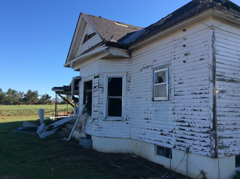
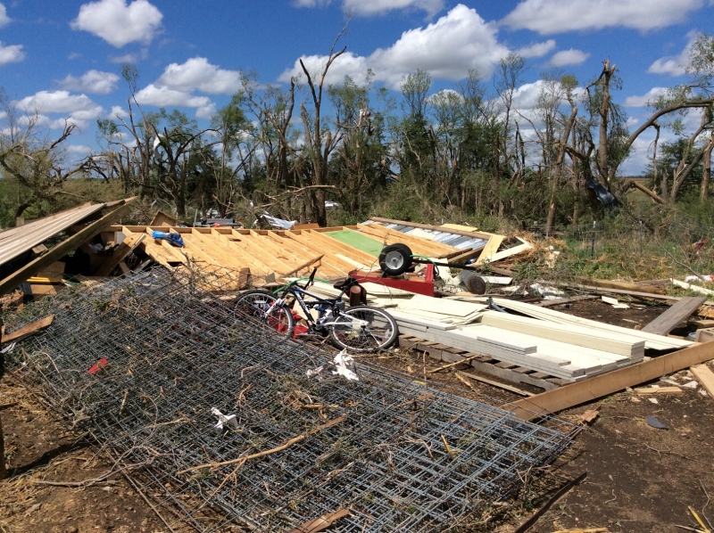
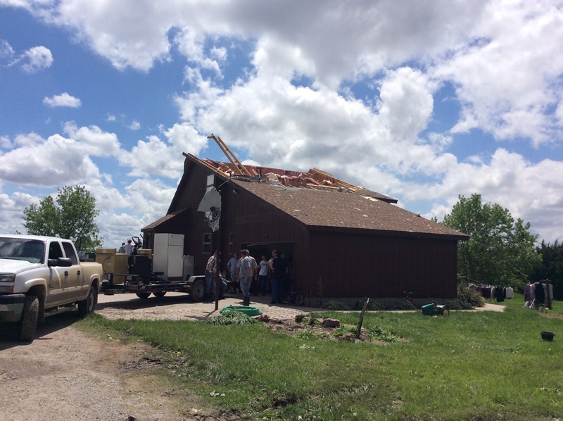
Damage along this tornado path included numerous pivots overturned and snapped power poles. A large amount of tree damage was noted. This tornado crossed the far SE portion of the town of Hardy, causing tree and minor building damage. Several outbuildings and grain bins along the path were damaged or destroyed, with a couple of homes losing portions of their roofs.


Photos from NWS Survey.


Tornado #6:  2.5 SE to 3.5 NE of Formoso, KS (Jewell County)

Rating: EF-1
Estimated Peak Wind Speed: 110 mph
Time: 4:54 - 5:04 p.m. CDT
Path Length: 4.37 miles
Max Path Width: 250 yards
Fatalities/Injuries: 0 / 0

A home along this path sustained roof/window/siding damage, with an outbuilding destroyed. Tree and power pole damage was also noted along the path.


Photos from NWS Survey.


Tornado #7:  4.5 SE to 5.5 ESE of Randall, KS (Jewell County)

Rating: EF-1
Estimated Peak Wind Speed: 90 mph
Time: 5:04 - 5:10 p.m. CDT
Path Length: 3.13 miles
Max Path Width: 60 yards
Fatalities/Injuries: 0 / 0

Damage from this tornado was confined to trees. The path was determined from video and eyewitness accounts.


Tornado #8:  1 NW to 1 N Byron, NE (Thayer County)

Rating: EF-0
Estimated Peak Wind Speed: 80 mph
Time: 5:28 - 5:31 p.m. CDT
Path Length: 1.12 miles
Max Path Width: 30 yards
Fatalities/Injuries: 0 / 0

No damage was reported with this tornado. The path was determined from video and radar information.


Tornado #9:  3 W of Grand Island, NE (Hall County)

Rating: EF-0
Estimated Peak Wind Speed: 75 mph
Time: 5:45 p.m. CDT
Path Length: Brief touchdown.
Max Path Width: 25 yards
Fatalities/Injuries: 0 / 0

This tornado was reported by a trained spotter. No damage occurred.


Tornado #10:  2 WSW of Chester to 3 SE Hebron, NE (Thayer County)

This path is a continuation of a tornado which started in Republic County, KS in the Courtland/Scandia area.

Rating: EF-2 (EF-1 in Thayer County)
The EF-2 damage was noted in Republic County, KS. EF-1 damage was noted in Thayer            County, NE. Since it was one continuous tornado, the entire tornado is rated EF-2.
Estimated Peak Wind Speed: 120 mph (Strongest in Republic County, KS)
Time: 6:04 - 6:19 p.m. CDT in Thayer County
Path Length: Approximately 37 miles (26 in Republic County, KS - 11 in Thayer County)
Max Path Width: 800 yards
Fatalities/Injuries: 0 / 0

In the Thayer County, NE portion of this tornado path, trees were damaged and pivots overturned. A home southeast of Hebron had its roof partially torn off. This tornado crossed Highway 81 approximately 6 miles south of Hebron.


Photos from NWS Survey.


Tornado #11:  4 SW to 3 W of Carleton, NE (Thayer County)

Rating: EF-0
Estimated Peak Wind Speed: 80 mph
Time: Unknown at this time
Path Length: 1.8 miles
Max Path Width: 100 yards
Fatalities/Injuries: 0 / 0

Damage from this tornado included an overturned train car west of Carleton. Irrigation pivots were also overturned in the area.


Heavy Rainfall/Flooding:

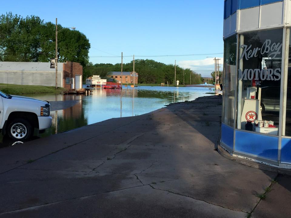
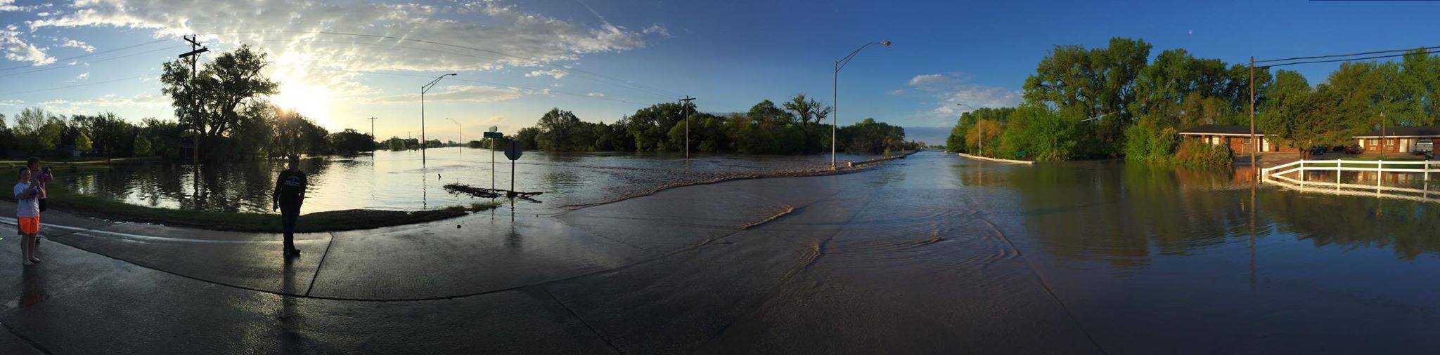
In addition to damaging tornadoes, flooding also became a major story within a narrow, but significant corridor of very heavy rain that fell across southeast sections of the local area, resulting in widespread flooding that lasted well into Thursday, May 7th. According to Doppler radar estimation (see image below) and numerous rain gauge reports, a roughly 10-20 mile wide, southwest-to-northeast corridor received a widespread 5-9" of rain (and locally higher), especially across much of Thayer, southern and eastern Nuckolls, and northern and western Jewell counties within the NWS Hastings area. The heart of this heaviest rainfall axis was generally centered through the Alexandria-Hebron-Hardy NE areas, then southwestward through the Burr Oak-Esbon-Portis KS areas. In and near these communities, numerous creeks and streams flooded, covering many roadways. The Republican River also flooded along the state line between Nuckolls/Jewell counties, including near Hardy. This significant rainfall/flooding was a result of numerous thunderstorms repeatedly "training" over the same area over the course of several hours.

Here is a listing of just a few of the highest 24-hour rainfall amounts from within the heavist corridor:

  • 4W Hebron: 10.91" (NeRAIN observer)
     
  • 4WNW Alexandria: 8.78" (NeRAIN observer)
     
  • Byron: 8.78" (NeRAIN observer)
     
  • Hebron: 8.59" (NWS cooperative observer...this was the highest 24-hour total on record dating to 1893)
     
  • 4E Hardy: 8.20" (NeRAIN observer)
     
  • Superior: 7.13: (NWS cooperative observer...this was the highest-24-hour total on record dating to 1893)
     
  • 3ENE Webber KS: 7.92" (CoCoRaHS observer)
     
  • Burr Oak KS: 6.43" (NWS cooperative observer)
Forecast Area-Centric Precipitation Map
Regional Recipitation Map


Flooding in Hebron. Photos courtesy of the Hebron Journal-Register.


Flooding in Hebron. Photo courtesy of Shevin Solomon.


This page was composed by the staff at the National Weather Service in Hastings, Nebraska.