|
Detailed Event Summary:
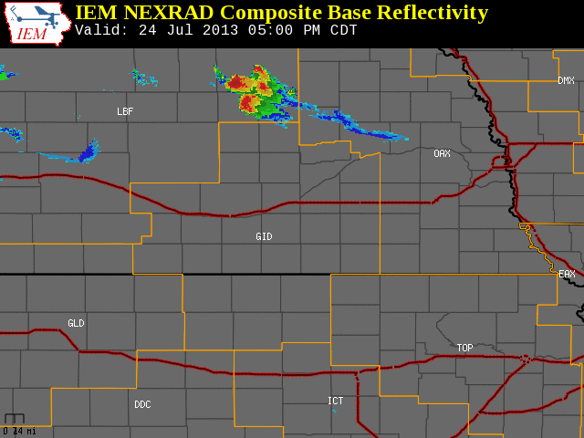
Between 530-730 pm on Wednesday, July 24, 2013, a large, powerful supercell thunderstorm tracked south-southeast through northern portions of South Central Nebraska, resulting in a concentrated swath of wind and hail damage likely no more than 5-10 miles wide. According to an NWS storm survey, straight-line wind gusts of 70-100 MPH occurred from central/eastern Valley County, southeastward to near the Valley/Sherman County line south of North Loup. This storm first entered the local area into central and eastern Valley County (including the Ord area) and extreme western Greeley County between 530-600pm, and reached the North Loup area around 630pm and the Ashton area around 700pm, before it quickly weakened and dissipated in extreme northwestern Hall County around 730pm. Prior to sinking southward into the NWS Hastings coverage area, the initial development of isolated severe storms got underway in north central Nebraska during the mid-afternoon hours as a weak upper level disturbance interacted with a strongly unstable airmass and unusually strong upper level wind shear for late-July.
Some of the notable preliminary reports from Wednesday evening follow below:
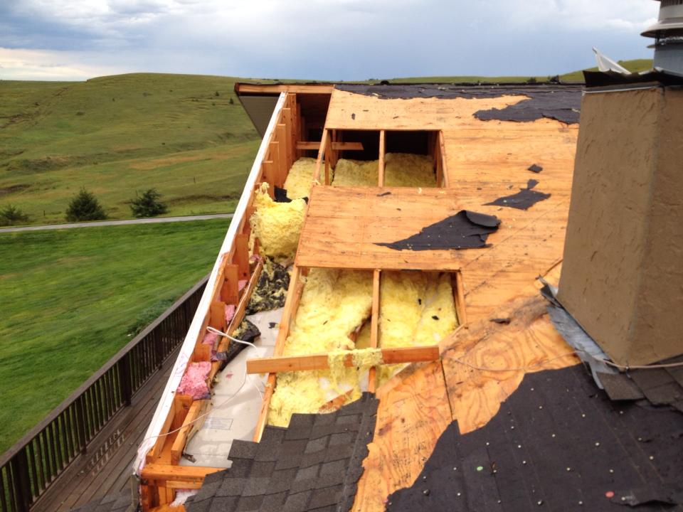
- Strong thunderstorm winds resulted in significant roof damage to a home 4 miles east of Ord (Valley County).
- Strong thunderstorm winds heavily damaged a barn and multiple grain bins 7 miles SSW of North Loup (Valley County).
- Strong thunderstorm winds and large hail resulted in overturned irrigation pivots, crop and grain bin damage south of
North Loup (Valley County).
- Golf ball size hail (1.75") was reported in Ord (Valley County) along with 60 MPH wind gusts.
- Ping pong ball size hail (1.50") was reported near Ashton (Sherman County) and in Boelus (Howard County).
- Walnut size hail (1.25") was reported near North Loup (Valley County)
 |
July 24, 2013 storm reports.
Click image for detailed reports. |
 |
 |
 |
| Crop damage approx. 7 SSW of North Loup. |
Overturned irrigation pivot approx. 7 SSW
of North Loup. |
Grain bin destroyed approx.7 SSW
of North Loup. |
 |
 |
 |
| Roof damage suffered at a home 4 miles east-southeast of Ord on Highway 11. Photos courtesy of Matt Geiser. |
 |
 |
 |
| Damage to a barn in southeastern Valley county. |
Damage to a storage shed in southeastern Valley county. |
Damage to cattle feeding bunkers and a power pole in southeastern Valley county. |
|