|
Detailed Event Summary:
On the late afternoon and evening of Memorial Day 2013, an upper level disturbance shifting out of the Rocky Mountains and onto the Central Plains brought yet another round of severe thunderstorms to South Central Nebraska and North Central Kansas. Through the afternoon hours, increased dewpoints allowed for high amounts of instability, while wind shear was also picking up across the area. A surface warm frontal boundary would provide an extra focus, and thunderstorms which developed quickly became severe. Very large hail and damaging winds were reported along with heavy rain, but the main story was with the confirmed tornadoes.
Some of the notable reports from Monday afternoon and evening follow below:
- Tornadoes reported in Smith/Jewell Counties of North Central Kansas and in Clay County of South Central Nebraska (see below for more detailed information regarding these tornadoes)
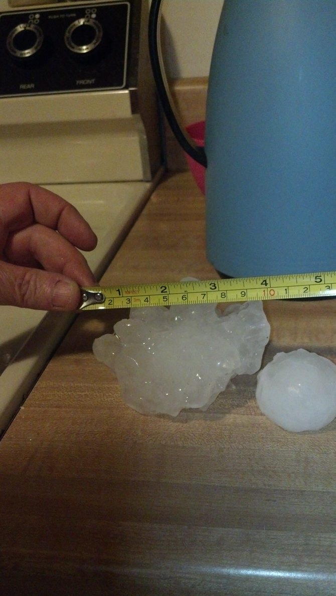
- Near Montrose, KS - Hail measured at 5.25" in diameter was reported.
- Tennis Ball size hail (2.5") was reported in Mankato, KS.
- Hen egg size hail (2.0") was reported in Burr Oak, KS.
- Golf ball size hail (1.75") was reported near Odessa and Republican City.
- Ping Pong ball size hail (1.5") was reported near Funk and in Burr Oak, KS.
- Quarter size hail (1.0") was reported near Huntley, Kearney, Hastings, Smith Center, KS, Beloit, KS, and Ebson, KS.
- 78 mph wind gust was recorded near Davenport.
- 74 mph wind gust was recorded near Ayr.
- An estimated wind gust of 70 mph was reported near Strang.
- An estimated wind gust of 60 mph was reported near Agra, KS and Carleton.
 |
 |
 |
Very large hail in Mankato, KS. Photo courtesy of
Bryce Kintigh. |
Very large hail in Mankato, KS. Photo courtesy of Freda Brown. |
Very large hail near Montrose, KS. Photo courtesy of Dr. Mike Brown and the Mississippi State Storm Chase Team. |
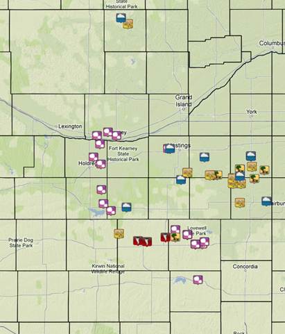 |
May 27, 2013 storm reports.
Click image for detailed reports. |
EF-3 Tornado - Smith and Jewell Counties of North Central Kansas (near Lebanon and Esbon)
Rating: EF-3
Time: 7:04 to 7:20 p.m. CDT
Path Length: 5.79 miles
Max Path Width: 1580 yards
Estimated Max Wind Speed: 140 mph
 |
Tornado track map of the
Lebanon Tornado. |
 |
 |
 |
 |
| Damage from hardest hit home, located approximately 3 miles NE of Lebanon, KS. |
 |
 |
 |
 |
| Damage at another home also located approximately 3.5 miles NNE of Lebanon, KS. |
 |
 |
 |
 |
| Tree and outbuilding damage approx. 3 NE of Lebanon, KS |
House and tree damage approx 2 NW of Esbon, KS. The photo on the right shows a snapped tree, then the truck pushed into the stump by the tornado. |
EF-2 Tornado - Clay County of South Central Nebraska (near Edgar)
Rating: EF-2
Time: 7:32 to 7:40 p.m. CDT
Path Length: Approximately 5 miles
Max Path Width: 250 yards
Estimated Max Wind Speed: 115 mph
In addition to the tornado, damaging straight line winds occurred over portions of Clay, Fillmore and Thayer Counties.
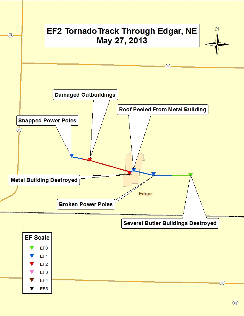 |
Track map of the
Edgar Torando. |
 |
 |
 |
 |
| Damage approx 2 west of Edgar. |
Damage in the southwestern portion of Edgar. |
Damage in the central portion of Edgar. |
Pivot overturned east of Edgar. |
 |
 |
 |
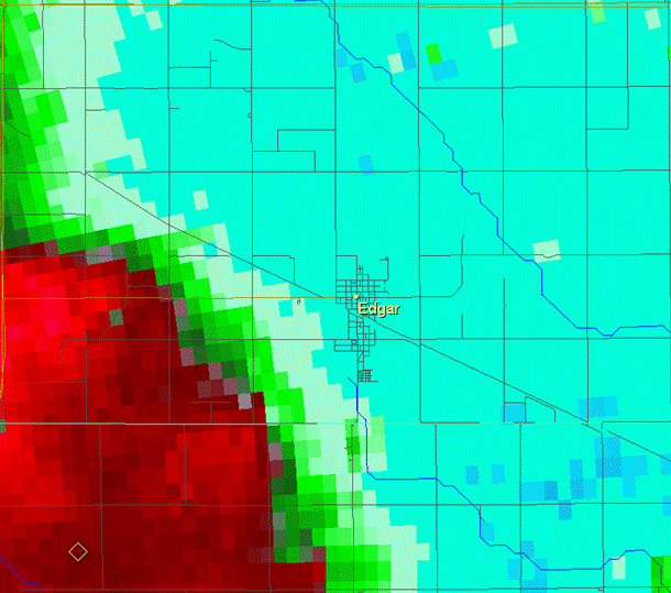
| Storm-relative velocity images from 7:30, 7:35 and 7:40 p.m. CDT |
EF-0 Tornadoes - Smith County of North Central Kansas (near Smith Center)
Location: Approximately 3.5 miles NW of Smith Center
Rating: EF-0
Time: 6:32 - 6:36 p.m. CDT
Path Length: 0.40 miles
Max Path Width: 15 yards
Estimated Max Wind Speed: 75 mph
Location: Approximately 1 mile N of Bellaire
Rating: EF-0
Time: 6:45 p.m. CDT (Brief touchdown)
Path Length: 0.10 miles
Max Path Width: 10 yards
Estimated Max Wind Speed: 75 mph
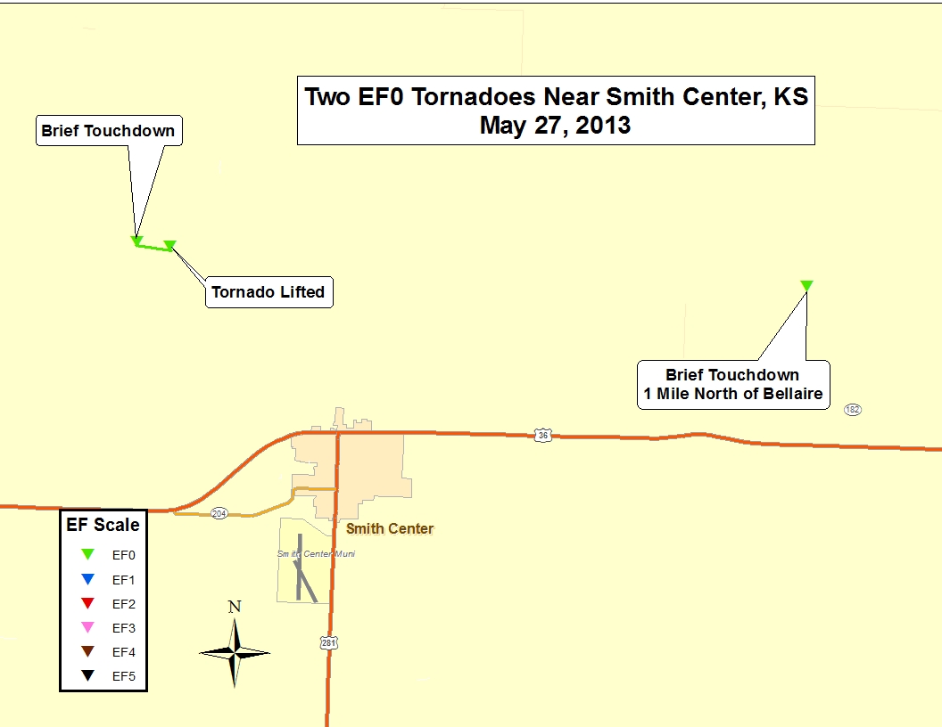 |
| Tornado track maps of both tornadoes. |
|


