|
Detailed Event Summary:
A mid level low pressure moving onto the Plains and upper level jet streak nosing in from the southwestern U.S., combined with a number of surface boundaries present, brought a drawn out epsiode (over 12 hours) of strong to severe thunderstorms to the National Weather Service Hastings coverage area on Saturday, April 14th. Surface low pressure deepening over western Kansas through the day helped to draw a warm front north through the region, bringing increased moisture, shear and instability, while a dry line pushed in from the west. It was an early start to the event, with the first severe thunderstorm warnings being issued before 11 a.m. CDT, and warnings continued all day and into the late evening, with the last warning going out the door just before midnight. Hail up to the size of baseballs, damaging wind gusts over 60 mph, and torrential rainfall were all reported across the area.
In addition, several reports of funnel clouds and a few tornadoes were received. Preliminary reports indicate that these tornadoes were not long-lasting, and did not produce widespread serious damage or injuries.
Tornado Details: 5 tornadoes have been confirmed from this event based on a variety of sources, including NWS surveys, storm chaser/spotter video and pictures, emergency management reports and WSR-88D radar data. NWS Hastings extends a big "Thank You" to all individuals who provided storm reports, including photos and video.
Mitchell County: 1 confirmed EF1 tornado
Location: About 3 miles south south of Tipton, Kansas to about 1 mile south-southeast of Tipton, Kansas
Rating: EF1
Path Length: Approximately 3 miles
Path Width: 300 yards
Maximum Estimated Wind Speed: 95 MPH
Time: 2:03 PM TO 2:12 PM
Damage: This tornado touched down approximately 3 miles south of Tipton, crossed Highway 181 before lifting approximately 1 mile southeast of Tipton. Along its path, trees up to 4 ft in diameter were damaged or destroyed, outbuildings and garages were damaged or destroyed, homes suffered roof and siding damage and power poles were tipped or blown down completely. The maximum wind speed was estimated at 95 mph.
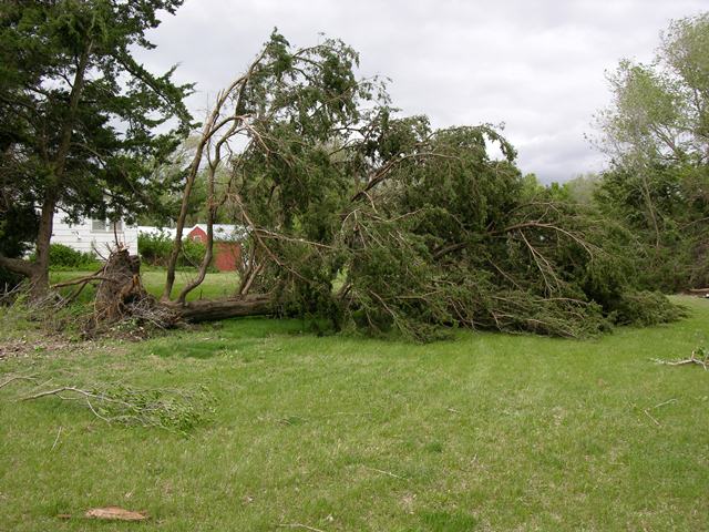
Mitchell County Tornado and Damage
 |
 |
 |
| Farm property displaced by the tornado. |
Clean up the next day from the aftermath. |
Outbuilding destroyed. Our Warning Coordination Meteorologist (WCM) stands by during our damage survey. |
 |
 |
 |
| More damage from the Tipton area in Mitchell county. |
Tree split from brief tornado touch down. |
A tornado snapped a tree near the base. |
 |
 |
 |
| Garage destroyed but luckily some of the property inside was unharmed. |
Snapped tree in Mitchell county. |
Tree uprooted from EF0 winds in Tipton. |
 |
 |
| Track of EF0 tornado located about 1 to 3 miles south of Tipton. |
The same track of the EF0 tornado as shown in Google Earth view. |
Harlan County: 1 confirmed EF0 tornado
Location: About 4 miles north-northeast of Oxford, Nebraska
Rating: EF0
Path Length: Approximately 1 mile
Path Width: 40 yards
Maximum Estimated Wind Speed: 65 MPH
Time: 6:16 PM TO 6:19 PM
Damage: This tornado touched down approximately 4 miles north-northeast of Oxford, crossing Highway 6 before dissipating approximately 5 miles north-northeast of Oxford. The only damage noted with this tornado was the destruction of a grain bin near Highway 6. The maximum wind speed was estimated at 65 mph.
Harlan County Tornado and Damage
 |
 |
| Track of EF0 tornado located about 4 miles northeast of Oxford. |
The same track of the EF0 tornado as shown in Google Earth view. |
Nuckolls County: 1 confirmed EF0 tornado
Location: Touchdown was 1 mile east of Hardy, Nebraska. This tornado lifted about 4 miles east of Hardy.
Rating: EF0
Path Length: Approximately 3 miles
Path Width: 40 yards
Time: 2:10 PM TO 2:14 PM
Damage: None reported.
Nuckolls County Tornado
 |
 |
|
Tornado in Nuckolls County. Photo courtesy of Jeff and Julie Gonzales.
|
Approximately 1-2 miles east of Hardy, looking west. Photo courtesy of Brian Onstead.
|
Thayer County: 1 confirmed EF0 tornado
Location: About 2 miles east of Deshler, Nebraska
Rating: EF0
Path Length: 0.10 miles (brief touch down)
Path Width: 25 yards
Time: 2:30 PM
Damage: None reported.
Thayer County: 1 confirmed EF0 tornado
Location: North of Alexandria, Nebraska
Rating: EF0
Path Length: Approximately 1/2 of a mile
Path Width: 60 yards
Maximum Estimated Wind Speed: 75 MPH
Time: 2:56 - 3:00 PM
Damage: This tornado touched down approximately 1.5 miles north of Alexandria and lifted approximately 2 miles north of Alexandria. Along its path, a home sustained minor siding and window damage, a grain bin was destroyed, small outbuildings lost siding, trees and power lines were damaged, and 2 center irrigation pivots were overturned. The maximum wind speed was estimated at 75 mph.
Additional reports:
- There were numerous reports of hail to at least golfball size. A few of these reports included 2-inch diameter hail 3 miles north of Spalding at 1154 AM, golfball size hail near Heartwell at 907 PM and baseball size hail south of Glenvil at 1007 PM.
|

|
|
Hail up to golf ball size, near Heartwell, NE. Photo courtesy of Sherry Reichstein.
|
- In addition to tornadoes, hail and wind damage, a fairly large portion of the NWS Hasting coverage area picked up rainfall amounts in excess of 1 or 2 inches, especially east of a line from Osceola to Hastings, NE, through Osborne, KS. A few of the highest 24-hour rainfall totals as of 7 AM on the 15th included: 3.56 inches at Beloit KS, 3.34 inches at Bruning, NE, and 3.07 inches 3 miles west of Ruskin, NE.
- For an interactive map of all preliminary storm reports, please click the image below...
 |
|
Preliminary Storm Reports from April 14, 2012
|
For a map of precipitation from April 14th, please click the image below...
 |
|
Precipitation Reports from April 14, 2012
|
The following table includes a few of the 24 hour precipitation totals from around the area ending the morning of Sunday, April 15th. Locations followed by a * denotes a NeRAIN or CoCoRaHS Observer, the remainder are NWS Cooperative Observers.
|
Location
|
Rainfall (inches)
|
|
2 WSW Tobias*
|
3.70
|
|
Beloit, KS
|
3.56
|
|
Bruning
|
3.34
|
|
3 W Ruskin*
|
3.07
|
|
4.7 SSW Deshler*
|
2.63
|
|
Naponee
|
2.40
|
|
3 N York
|
2.26
|
|
6.8 SSE Ord*
|
2.14
|
|
2.6 ESE Hampton*
|
2.11
|
|
Hunter, KS
|
2.05
|
|
4.4 SW Bladen*
|
2.02
|
|
4.4 E Arcadia*
|
1.96
|
|
Clay Center
|
1.95
|
|
Cawker City, KS
|
1.65
|
|


