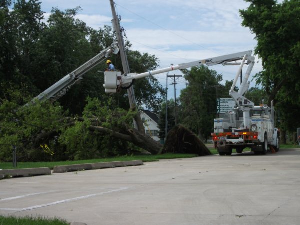
Thunderstorms developed along a cold frontal boundary late Saturday evening, June 26th, and the storms continued into the early morning hours of June 27th. A few thunderstorms became severe and produced damaging winds in excess of 60 mph, half dollar size hail, and locally heavy rainfall in excess of two inches. The city of Geneva, NE sustained the most damage from the storms, where winds exceeded 70 mph and caused considerable tree damage. The following storm damage photographs are courtesy of Terry Marshall, trained storm spotter. All photographs were taken in Geneva, NE.
 |
 |
 |
 |
 |
 |
 |
 |
 |
The radar loop below, courtesy of the Iowa Environmental Mesonet (Iowa State University), depicts early morning storms across southern Nebraska,Sunday, June 27, 2010. The wind damage in Geneva (pictured above) took place primarily between 2:45 am and 2:50 am.
 |
PRELIMINARY LOCAL STORM REPORT
NATIONAL WEATHER SERVICE HASTINGS NE
.TIME... ...EVENT... ...CITY LOCATION... ...LAT.LON
.DATE... ....MAG.... ..COUNTY LOCATION..ST.. ...SOURCE.
..REMARKS..
1135 PM HAIL 12 WNW PHILLIPSBURG 39.82N 99.53W
06/26/2010 E0.88 INCH PHILLIPS KS CO-OP OBSERVER
0218 AM HAIL 2 ESE GENEVA 40.53N 97.60W
06/27/2010 E1.00 INCH FILLMORE NE TRAINED SPOTTER
0232 AM HAIL 1 NNE GENEVA 40.54N 97.59W
06/27/2010 E1.00 INCH FILLMORE NE TRAINED SPOTTER
0235 AM HAIL 1 N GENEVA 40.54N 97.60W
06/27/2010 M1.25 INCH FILLMORE NE TRAINED SPOTTER
0243 AM HAIL 2 N GENEVA 40.56N 97.60W
06/27/2010 E0.75 INCH FILLMORE NE TRAINED SPOTTER
0247 AM TSTM WND DMG GENEVA 40.53N 97.60W
06/27/2010 FILLMORE NE EMERGENCY MNGR
6 TO 8 INCH DIAMETER TREES LIMBS AND BIGGER DOWN IN TOWN.
MINOR ROOF DAMAGE AT TWO LOCAL BUSINESSES. 3 LARGE TREES
SPLIT IN TOWN. TWO-THIRDS OF TOWN WITHOUT POWER. NICKEL
SIZE HAIL REPORTED. LOCAL FIRE CHIEF ESTIMATED WINDS IN
EXCESS OF 70 MPH. WIND GUSTS LASTED 5 TO 10 MINUTES.
0330 AM HEAVY RAIN GENEVA 40.53N 97.60W
06/27/2010 M2.40 INCH FILLMORE NE TRAINED SPOTTER
MOST OF THE RAIN CAME IN 30 MINUTES
0758 AM HEAVY RAIN 4 SW BLADEN 40.28N 98.65W
06/27/2010 M2.03 INCH WEBSTER NE PUBLIC
OVERNIGHT RAINFALL TOTAL. COURTESY NEBRASKA RAINFALL
ASSESSMENT AND INFORMATION NETWORK
0758 AM HEAVY RAIN 2 NE BLUE HILL 40.35N 98.42W
06/27/2010 M2.04 INCH ADAMS NE PUBLIC
OVERNIGHT RAINFALL TOTAL. COURTESY NEBRASKA RAINFALL
ASSESSMENT AND INFORMATION NETWORK

