A supercell thunderstorm spawned tornadoes in eastern Buffalo county during the evening on Wednesday, June 17. Tornadoes were reported in the area 9 miles north and 2 miles west of Gibbon. National Weather Service storm damage assessment teams surveyed the damage and rated the primary tornado EF1, with winds between 86 and 110 mph. A description of the EF scale can be found here. The main tornado had a path length of 1.5 miles and a maximum width of 200 yards. At least two farms were damaged. At the first farmstead along Pole Line Road and Maple Road, a quonset was leveled and garage doors to a second quonset were blown off. Grain bins sustained damage, and the east wall of the farm house was bowed. A second farm was damaged along Navaho Road and Pole Line Road. In this area, there are indications of a multiple vortex tornado. Two houses were located on the farmstead. A window was blown out of one of the houses, and shingle and outbuilding damage also occurred. Round hay bales were rolled approximately 50 yards.
Based upon storm spotter and storm chaser reports, the first tornado occurred from 6:54 pm to 6:57 pm, and caused the EF1 damage to the farmsteads. The second tornado was very brief and lasted about 1 minute around 7:05 pm CDT, with minor crop and tree damage noted.
Maps of the tornado touchdown locations are shown below. Green tornado icons depict EF0 damage and Blue tornado icons depict EF1 damage.
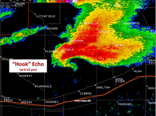
Below are a couple of radar images of the supercell thunderstorm and tornadic circulation.
Radar images of the supercell thunderstorm (click on images for larger view)
| Radar reflectivity image at 6:55 P.M. |
Storm relative motion image at 7:04 P.M. (tornadic circulation of the winds noted where the Red and GREEN are next to each other in the circle) |
 |
 |
Damage photographs taken by the NWS damage assessment team are shown below. Click on the thumbnails to enlarge the pictures.
 |
 |
 |
 |
 |
 |
 |
 |
 |
 |