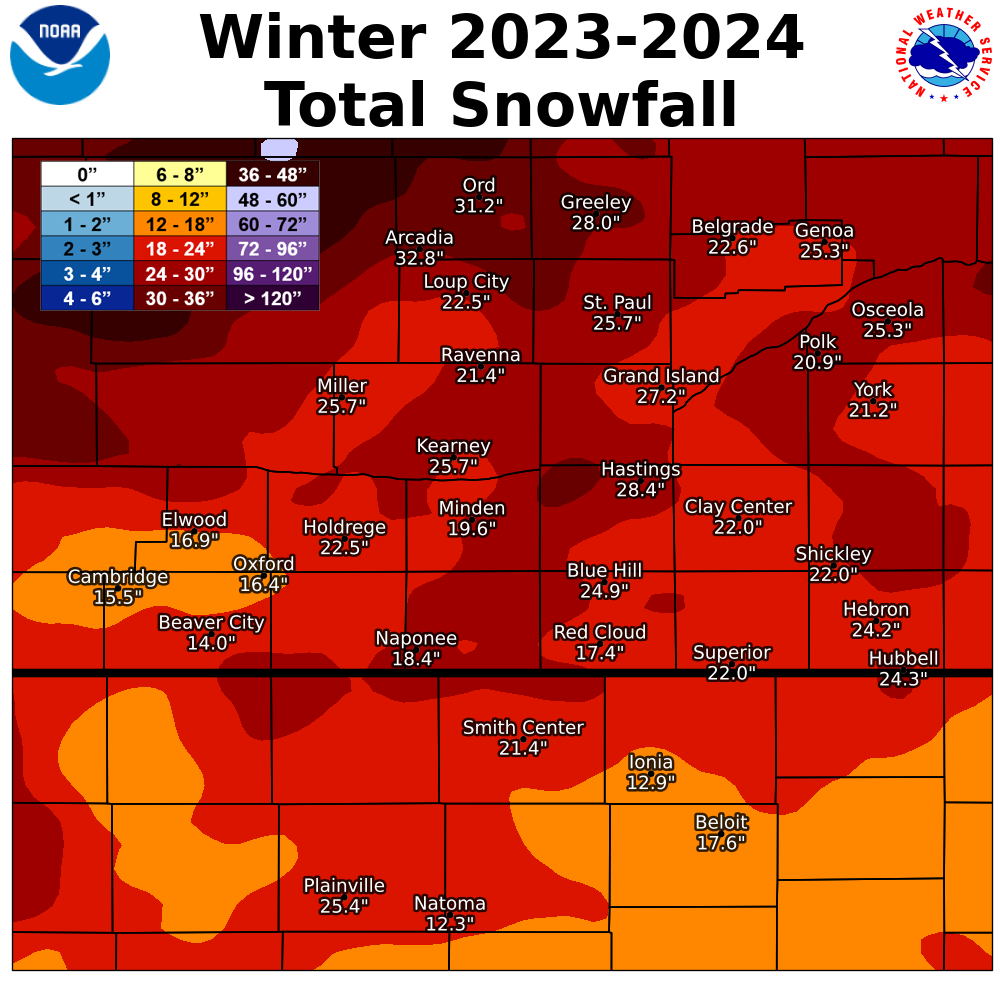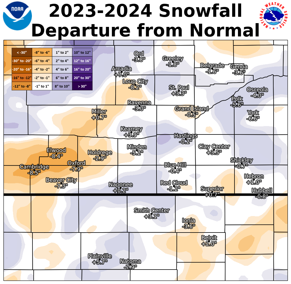
Although most of our 30-county coverage area has yet to see its first snowflakes THIS SEASON (the 2024-25 season), this story takes a look back at snowfall totals from LAST SNOWFALL SEASON (the 2023-24 season...meaning Fall 2023-Spring 2024).
As covered in more detail below, one of the most notable things about last winter was how incredibly "normal" seasonal snow totals were...for the second straight season! As was the case during the 2023-23 season, most of our area again ended up within 5" either side of their official 30-year normal. That being said, it's also worth noting that for many places (not all), a good 40-60% of total seasonal snowfall fell OVER THE COURSE OF JUST 6 DAYS...JANUARY 8-13, 2024!
Below (click on the tabs) are graphics and tables that outline seasonal totals, departures from normal/average etc. for the 2023-24 snowfall season. Before continuing though, and in order to better give last season's totals some perspective, official 30-year snowfall normals/averages within our coverage area are:
"Normal"/average seasonal snowfall within our coverage area (based on 1991-2020 NCEI data):
** Note: You can always access local daily/monthly/seasonal snowfall maps (updated DAILY) here: https://www.weather.gov/gid/Snow
NWS Hastings Coverage Area (24 Nebraska counties/6 Kansas counties)
2023-24 Seasonal Snow and Departure From Normal
(click images to enlarge)
 |
 |
| NWS HASTINGS AREA 2023-24 Snow Season Totals |
NWS HASTINGS AREA 2023-24 Snow Departure From Normal |
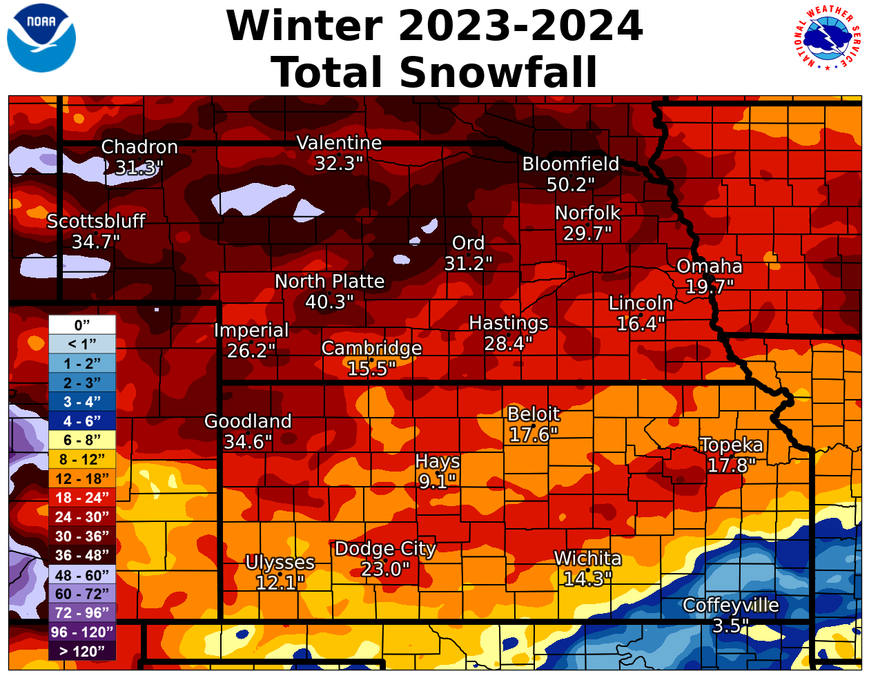
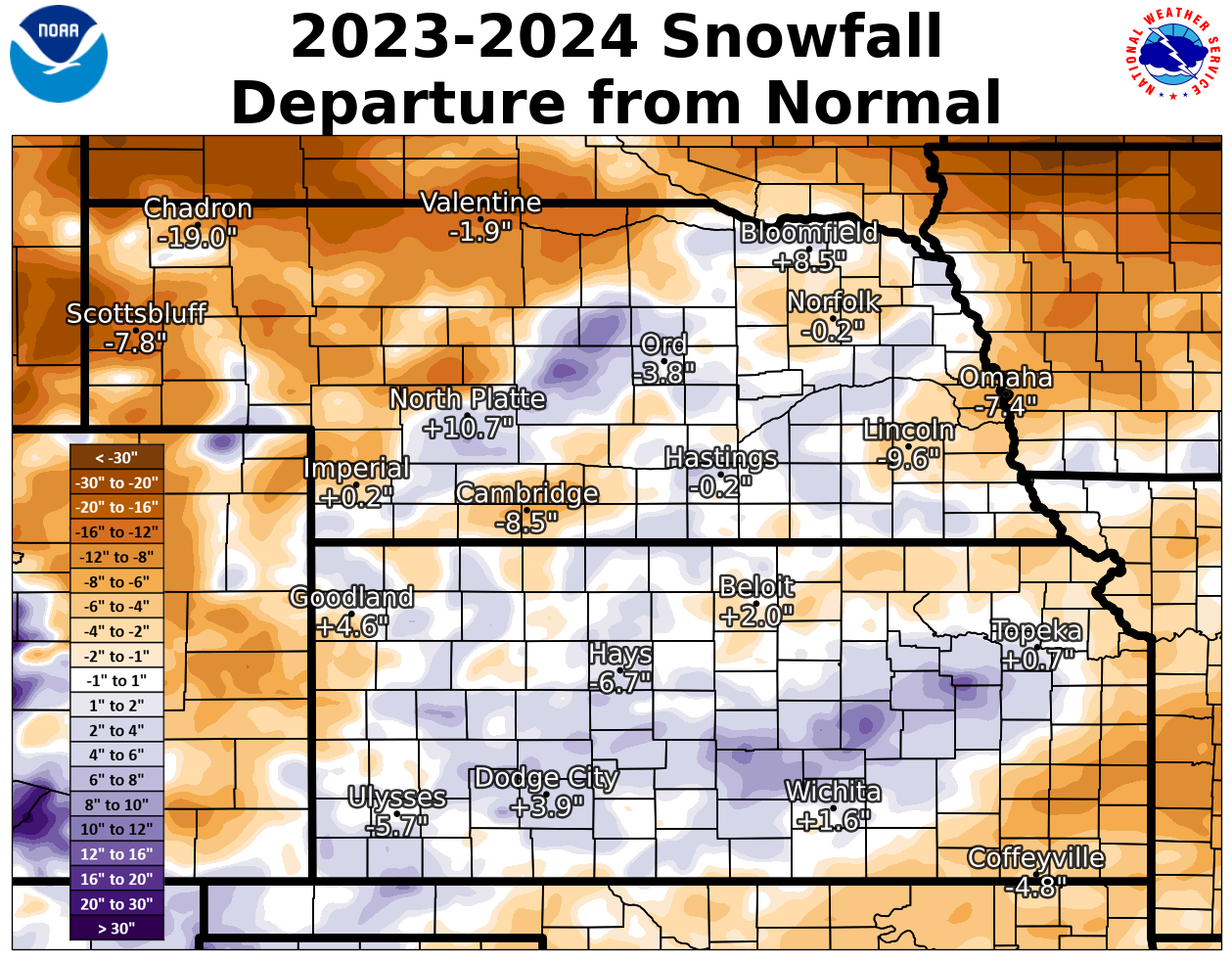
2023-24 Regional Seasonal Snow Totals + Departures From Normal
(click images to enlarge)
 |
 |
| REGIONAL 2023-24 Snow Season Totals | REGIONAL 2023-24 Snow Season Departures From Normal |
WINTER 2023-2024 SOUTH CENTRAL NEBRASKA
NWS COOPERATIVE OBSERVER SNOWFALL
The highest reported amount under each month indicated in BLUE, the lowest amount in RED.
M indicates incomplete/missing data. T* indicates hail was reported during the month.
| Station | Sep | Oct | Nov | Dec | Jan | Feb | Mar | Apr | May | Season |
| Arcadia 2W | T* | 3.5 | 0.8 | 6.5 | 10.8 | 0.2 | 11.0 | 0.0 | 0.0 | 32.8 |
| Beaver City | 0.0 | T | T | 4.0 | 5.9 | T | 4.1 | 0.0 | 0.0 | 14.0 |
| Belgrade | T* | 2.0 | 0.3 | 3.0 | 13.3 | 1.5 | 2.5 | 0.0 | 0.0 | 22.6 |
| Blue Hill 4SW | 0.0 | 0.1 | 0.7 | 6.4 | 13.2 | T | 4.5 | 0.0 | 0.0 | 24.9 |
| Bradshaw | 0.0 | 0.3 | 0.4 | 8.2 | 13.1 | 0.1 | 1.1 | 0.0 | 0.0 | 23.2 |
| Cambridge | 0.0 | 1.0 | 2.0 | 2.0 | 3.5 | T | 7.0 | 0.0 | 0.0 | 15.5 |
| Lexington 6SSE (Canaday) | 0.0 | 0.0 | 0.0 | M | 4.2 | 0.1 | 4.8 | 0.0 | 0.0 | M |
| Clay Center 6ESE | 0.0 | 0.0 | 0.5 | 3.0 | 14.6 | 0.2 | 2.8 | 0.0 | 0.0 | 21.1 |
| Clay Center | 0.0 | 0.1 | 0.5 | 3.0 | 15.6 | T | 2.8 | 0.0 | 0.0 | 22.0 |
| Edison | 0.0 | 1.0 | 2.0 | 2.0 | 3.8 | T | 3.0 | 0.0 | 0.0 | 11.8 |
| Elwood 8S | 0.0 | 1.0 | 2.0 | 4.5 | 4.8 | 0.3 | 4.3 | 0.0 | 0.0 | 16.9 |
| Genoa 2W | 0.0 | 2.0 | 0.5 | 4.0 | 17.5 | 1.3 | T | 0.0 | 0.0 | 25.3 |
| Grand Island Airport | 0.0 | 0.9 | 0.9 | 3.3 | 17.4 | 0.3 | 4.4 | 0.0 | 0.0 | 27.2 |
| Greeley | T* | 2.4 | 1.6 | 5.1 | 12.8 | 1.1 | 5.0 | 0.0 | 0.0 | 28.0 |
| Gresham 3W | 0.0 | T | T | 3.5 | 19.1 | T | T | 0.0 | 0.0 | 22.6 |
| Harlan County Lake | 0.0 | T | 1.0 | 10.5 | 5.8 | 0.1 | 4.9 | 0.0 | 0.0 | 22.3 |
| Hastings NWS | 0.0 | 0.7 | 0.6 | 6.1 | 15.6 | 0.1 | 5.3 | 0.0 | 0.0 | 28.4 |
| Hebron | 0.0 | T | 1.4 | 4.3 | 14.9 | 0.5 | 3.1 | 0.0 | 0.0 | 24.2 |
| Holdrege | 0.0 | 1.0 | 2.0 | 4.5 | 8.0 | T | 7.0 | 0.0 | 0.0 | 22.5 |
| Hubbell | 0.0 | 0.0 | 2.0 | 4.0 | 14.0 | 0.3 | 4.0 | 0.0 | 0.0 | 24.3 |
| Kearney Airport | 0.0 | 1.3 | 1.1 | 4.1 | 10.3 | T | 8.9 | 0.0 | 0.0 | 25.7 |
| Loup City | 0.0 | 1.0 | 0.2 | 4.5 | 11.2 | 0.4 | 5.2 | 0.0 | 0.0 | 22.5 |
| Miller | 0.0 | 1.2 | 1.8 | 2.9 | 10.8 | T | 9.0 | 0.0 | 0.0 | 25.7 |
| Minden | 0.0 | 0.2 | T | 5.0 | 9.2 | T | 5.2 | 0.0 | 0.0 | 19.6 |
| Naponee | 0.0 | T | 0.0 | 8.5 | 8.0 | 0.0 | 1.9 | 0.0 | 0.0 | 18.4 |
| North Loup | 0.0 | 2.0 | 0.5 | 7.0 | 13.5 | 0.5 | 7.5 | 0.0 | 0.0 | 31.0 |
| Orleans 1W | 0.0 | 1.1 | 1.0 | 7.6 | 8.7 | 0.5 | 6.4 | 0.0 | 0.0 | 25.3 |
| Ord | T* | 2.0 | 1.8 | 7.5 | 11.7 | 0.9 | 7.3 | 0.0 | 0.0 | 31.2 |
| Osceola | 0.0 | 0.4 | 0.4 | 4.6 | 18.5 | 1.0 | 0.4 | 0.0 | 0.0 | 25.3 |
| Oxford 6NNW | 0.0 | 0.6 | 1.3 | 3.8 | 6.5 | T | 4.2 | 0.0 | 0.0 | 16.4 |
| Polk | 0.0 | 0.2 | 0.2 | 5.3 | 14.0 | 0.4 | 0.8 | 0.0 | 0.0 | 20.9 |
| Ravenna | 0.0 | 1.5 | 0.8 | 2.2 | 10.0 | T | 6.9 | 0.0 | 0.0 | 21.4 |
| Red Cloud | 0.0 | T | 1.0 | 4.5 | 8.9 | 0.5 | 2.5 | 0.0 | 0.0 | 17.4 |
| St. Paul | 0.0 | 0.7 | 0.7 | 5.9 | 11.8 | 0.2 | 6.4 | 0.0 | 0.0 | 25.7 |
| Shelby 3NE | 0.0 | T | T | 4.9 | 21.5 | 1.5 | 0.9 | 0.0 | 0.0 | 28.8 |
| Shickley 4S | 0.0 | 0.0 | 1.0 | 4.0 | 14.5 | T | 2.5 | 0.0 | 0.0 | 22.0 |
| Superior | 0.0 | 0.0 | 2.0 | 5.0 | 11.0 | 1.0 | 3.0 | 0.0 | 0.0 | 22.0 |
| Wilsonville | 0.0 | 1.0 | 2.0 | 4.0 | 8.5 | T | 6.0 | 0.0 | 0.0 | 21.5 |
| York 3N | 0.0 | 0.6 | 0.2 | 5.4 | 13.6 | 0.2 | 1.2 | 0.0 | 0.0 | 21.2 |
WINTER 2023-2024 NORTH CENTRAL KANSAS
NWS COOPERATIVE OBSERVER SNOWFALL
The highest reported monthly/seasonal totals indicated in BLUE, the lowest in RED.
M indicates incomplete/missing data. T* indicates hail was reported during the month.
| Station | Sep | Oct | Nov | Dec | Jan | Feb | Mar | Apr | May | Season |
| Beloit | 0.0 | T | 0.8 | 6.0 | 8.3 | 0.5 | 2.0 | 0.0 | 0.0 | 17.6 |
| Cawker City | 0.0 | T | 1.0 | 2.0 | 6.5 | T | 1.0 | 0.0 | 0.0 | 10.5 |
| Ionia | 0.0 | T | 1.1 | 2.0 | 9.0 | 0.3 | 0.5 | 0.0 | 0.0 | 12.9 |
| Kirwin Dam | 0.0 | 0.0 | 1.0 | M | 7.0 | 1.0 | 2.0 | 0.0 | 0.0 | M |
| Lebanon | T* | T | 1.6 | 5.5 | 14.8 | 0.3 | 2.0 | 0.0 | 0.0 | 24.2 |
| Logan | T* | T | T | 3.0 | 8.0 | M | M | M | M | M |
| Lovewell Dam | 0.0 | 0.0 | M | 6.0 | M | M | M | 0.0 | 0.0 | M |
| Natoma | 0.0 | T | 1.0 | 0.3 | 7.5 | 0.5 | 3.0 | 0.0 | 0.0 | 12.3 |
| Phillipsburg | T* | T | 0.2 | M | M | 0.6 | M | 0.0 | 0.0 | M |
| Plainville 4WNW | 0.0 | T | 1.0 | 4.6 | 13.7 | 1.0 | 5.1 | T | 0.0 | 25.4 |
| Smith Center | 0.0 | 0.0 | 1.0 | 3.5 | 13.0 | T | 3.9 | 0.0 | 0.0 | 21.4 |
| Webster Dam | 0.0 | 0.0 | 1.0 | 1.3 | 9.8 | 0.0 | 4.1 | 0.0 | 0.0 | 16.2 |
Various notes/highlights from the 2023-24 snowfall season (Oct. 2023-March 2024):
Within our 24 South Central/Central NE counties (per official NWS observers):
- The highest 2023-24 seasonal snow totals featured 32.8" near Arcadia (Valley County) and 31.2" in Ord (Valley County).
- The lowest official seasonal totals were 11.8" in Edison (Furnas County) and 14.0" in Beaver City (Furnas County).
Within our six North Central KS counties (per official NWS observers):
- The highest 2023-24 seasonal totals featured 25.4" near Plainville (Rooks County) and 24.2" in Lebanon (Smith County).
- The lowest official seasonal totals were 10.5" in Cawker City (Mitchell County) and 12.3" in Natoma (Osborne County).
In the Nebraska Tri Cities (from NWS observers near Grand Island/Kearney airports...and at Hastings NWS office):
- Grand Island: 27.2" (0.5" BELOW normal). This was very similar to the previous season (26.6" in 2022-23), marking the second straight very-near-normal season.
- Hastings: 28.4" (0.2" BELOW normal). This was very similar to the previous season (27.9" in 2022-23), marking the second straight very-near-normal season.
- Kearney: 25.7" (3.9" ABOVE normal). Although this was several inches less than the previous season (32.7" in 2022-23), it was still a few inches above normal.
- The FIRST MEASURABLE SNOW OF THE SEASON fell Oct. 28-29, 2023, as roughly the northwest half of our area picked up mainly between 0.5-2.5" (isolated totals up to 3.5" reported near Arcadia and Lexington).
- The LAST MEASURABLE SNOW OF THE SEASON occurred March 25-26, 2024, as the majority of our area picked up between 1-5", but ranging from only 0.5" or less in some Nebraska counties east of Highway 281, to as much as 6-8" in portions of several far north-northwest local counties (mainly Valley, Greeley, Sherman, Howard, Dawson, Buffalo).
 |
Media use of NWS Web News Stories is encouraged! Please acknowledge the NWS as the source of any news information accessed from this site. |
 |