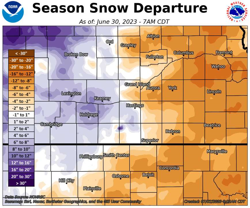
Although most of our 30-county coverage area has already had its first snow THIS SEASON (the 2023-24 season), this story takes a look back at snowfall totals from LAST SNOWFALL SEASON (the 2022-23 season...meaning Fall 2022-Spring 2023). As covered in more detail below, one of the most notable things about last winter was just how "normal" snow totals were across most of our coverage area, with most places totaling within 5" either side of their official 30-year normal amount. Of course, there were exceptions to this prevailing "normality", with some places (including Holdrege/Kearney) picking up at least 10" more than normal, and other places (such as York/Greeley/Beloit KS) falling at least 8-14" short of normal.
Below (click on the tabs) are graphics and tables that outline seasonal totals, departures from normal/average etc. for the 2022-23 snowfall season. Before continuing though, and in order to better give last season's totals some perspective, official 30-year snowfall normals/averages within our coverage area are:
"Normal"/average seasonal snowfall within our coverage area (based on 1991-2020 NCEI data):
** Note: You can always access local daily/monthly/seasonal snowfall maps (updated DAILY) here: https://www.weather.gov/gid/Snow
NWS Hastings Coverage Area (24 Nebraska counties/6 Kansas counties)
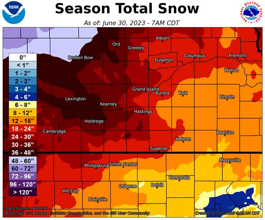
2022-23 Seasonal Snow and Departure From Normal
(click images to enlarge)
 |
 |
| LOCAL AREA 2022-23 Snow Season Totals |
LOCAL AREA 2022-23 Snowfall Departure From Normal |
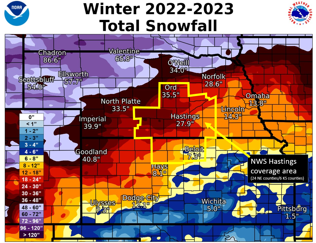
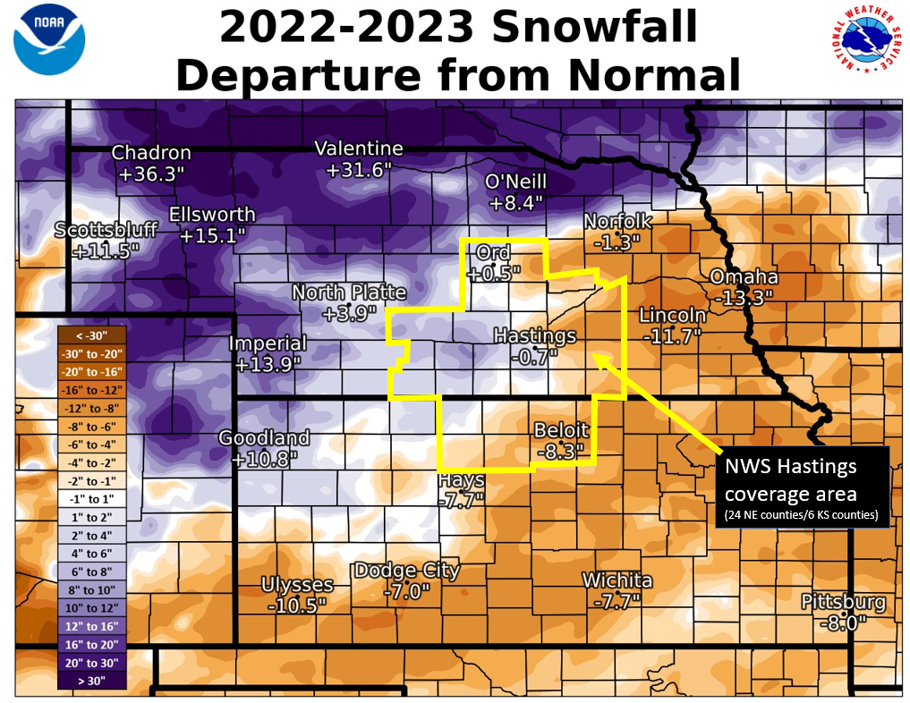
2022-23 Regional Seasonal Snow Totals + Departures From Normal
(NWS Hastings area in yellow outline)
(click images to enlarge)
 |
 |
| REGIONAL 2022-23 Snow Season Totals | REGIONAL 2022-23 Snow Season Departures From Normal |
WINTER 2022-2023 NEB. COVERAGE AREA
NWS COOPERATIVE OBSERVER SNOWFALL
The highest reported monthly/seasonal totals indicated in BLUE, the lowest totals in RED
T* indicates hail was reported during the month.
| Station | Oct | Nov | Dec | Jan | Feb | Mar | Apr | May | Season |
| Arcadia 2W | 0.0 | 0.7 | 5.5 | 21.7 | 1.8 | 2.4 | 0.3 | T* | 32.4 |
| Beaver City | 0.0 | 0.0 | 2.0 | 12.0 | 14.0 | 2.0 | 0.0 | 0.0 | 30.0 |
| Belgrade | 0.0 | 1.0 | 1.7 | 10.0 | 2.3 | 5.7 | 0.0 | 0.0 | 20.7 |
| Blue Hill 4SW | 0.0 | T | 2.2 | 11.7 | 10.2 | 2.6 | T | T* | 26.7 |
| Bradshaw | T* | 0.4 | 1.4 | 6.8 | 6.5 | 1.0 | T | 0.0 | 16.1 |
| Cambridge | 0.0 | 0.5 | 0.6 | 15.0 | 5.0 | 2.0 | 0.0 | 0.0 | 23.1 |
| Lexington 6SSE (Canaday) | 0.0 | T | 2.6 | 18.0 | 2.8 | 1.2 | 0.0 | 0.0 | 24.6 |
| Clay Center 6ESE | 0.0 | T | 2.0 | 5.0 | 7.1 | 2.0 | T | 0.0 | 16.1 |
| Clay Center | 0.0 | T | 1.9 | 6.2 | 8.2 | 1.7 | 0.0 | 0.0 | 18.0 |
| Edison | 0.0 | T | 1.0 | 12.0 | 7.0 | 1.0 | 0.0 | 0.0 | 21.0 |
| Elwood 8S | 0.0 | 0.1 | 3.7 | 17.8 | 6.5 | 6.0 | 0.0 | T* | 34.1 |
| Franklin | 0.0 | 0.0 | 2.0 | 8.5 | 8.0 | MSG | MSG | MSG | Incomplete |
| Geneva | 0.0 | MSG | MSG | 5.5 | 9.5 | 1.7 | T | 0.0 | Incomplete |
| Genoa 2W | 0.0 | T | 1.5 | 7.5 | 2.3 | 8.5 | 0.0 | 0.0 | 19.8 |
| Grand Island Airport | 0.0 | 0.4 | 1.8 | 12.3 | 5.0 | 7.1 | 0.0 | 0.0 | 26.6 |
| Greeley | 0.0 | 0.7 | 4.1 | 11.0 | 2.5 | 1.7 | T | 0.0 | 20.0 |
| Gresham 3W | 0.0 | T | 2.5 | 4.4 | 5.5 | 2.0 | T | 0.0 | 14.4 |
| Harlan County Lake | 0.0 | 0.0 | 0.5 | 10.3 | 11.0 | 0.3 | 0.0 | 0.0 | 22.1 |
| Hastings NWS | 0.0 | 0.5 | 2.5 | 11.5 | 9.8 | 3.6 | T | 0.0 | 27.9 |
| Hebron | 0.0 | 0.3 | 1.2 | 5.6 | 6.0 | 2.0 | 0.0 | T* | 15.1 |
| Holdrege | 0.0 | T | 3.0 | 13.0 | 10.0 | 10.0 | 0.0 | 0.0 | 36.0 |
| Hubbell | 0.0 | 0.2 | 1.0 | 5.5 | 5.0 | T | T | 0.0 | 11.7 |
| Kearney Airport | 0.0 | 0.3 | 2.5 | 13.1 | 6.2 | 10.6 | T | 0.0 | 32.7 |
| Loup City | T* | 0.5 | 5.0 | 16.8 | 1.7 | 2.8 | T | 0.0 | 26.8 |
| Miller | 0.0 | 0.6 | 3.5 | 19.9 | 2.6 | 4.0 | 0.0 | T* | 30.6 |
| Minden | 0.0 | 0.4 | 1.5 | 10.7 | 11.5 | 7.6 | 0.0 | T* | 31.7 |
| Naponee | 0.0 | 0.0 | 1.0 | 12.0 | 8.0 | 0.0 | 0.0 | T* | 21.0 |
| Nelson | 0.0 | MSG | MSG | MSG | MSG | MSG | MSG | MSG | Incomplete |
| North Loup | 0.0 | 0.6 | 2.0 | 16.0 | 1.5 | 0.5 | T | 0.0 | 20.6 |
| Orleans 1W | 0.0 | 0.2 | 2.0 | 11.3 | 8.5 | 0.5 | 0.0 | T* | 22.5 |
| Ord | 0.0 | 1.5 | 4.8 | 23.0 | 2.5 | 3.3 | 0.4 | T* | 35.5 |
| Osceola | 0.0 | 0.4 | 2.7 | 5.8 | 4.9 | 8.7 | T | T* | 22.5 |
| Oxford 6NNW | 0.0 | 0.3 | 2.8 | 11.6 | 8.3 | 3.6 | T | 0.0 | 26.6 |
| Polk | 0.0 | 0.5 | 2.5 | 7.0 | 4.3 | 5.0 | 0.0 | 0.0 | 19.3 |
| Ravenna | 0.0 | 1.0 | 1.0 | 16.5 | 5.0 | 5.0 | 0.0 | T* | 28.5 |
| Red Cloud | 0.0 | 0.0 | 2.0 | 11.0 | 6.5 | 0.5 | 0.0 | 0.0 | 20.0 |
| St. Paul | 0.0 | T | 2.1 | 13.8 | 2.9 | 7.0 | T | T* | 25.8 |
| Shelby 3NE | 0.0 | 0.5 | 2.2 | 6.7 | 4.7 | 7.8 | 0.0 | 0.0 | 21.9 |
| Shickley 4S | 0.0 | T | 1.5 | 6.0 | 9.0 | 1.0 | 0.0 | T* | 17.5 |
| Superior | 0.0 | 0.0 | 2.5 | 7.3 | 7.0 | 2.0 | T | 0.0 | 18.8 |
| Wilsonville | 0.0 | 2.0 | 3.0 | 12.6 | 10.0 | T | 0.0 | 0.0 | 27.6 |
| York 3N | 0.0 | 0.1 | 1.5 | 6.3 | 4.6 | 0.7 | T | 0.0 | 13.2 |
WINTER 2022-2023 KANSAS COVERAGE AREA
NWS COOPERATIVE OBSERVER SNOWFALL
The highest reported monthly/seasonal totals indicated in BLUE, the lowest totals in RED
T* indicated hail was reported during the month.
| Station | Oct | Nov | Dec | Jan | Feb | Mar | Apr | May | Season |
| Beloit | 0.0 | 0.5 | 1.0 | 5.5 | 0.3 | T | 0.0 | 0.0 | 7.3 |
| Cawker City | 0.0 | T | 0.1 | 1.0 | 0.7 | T | 0.0 | 0.0 | 1.8 |
| Ionia | 0.0 | 0.4 | 0.7 | 5.4 | 2.0 | 0.4 | T* | 0.0 | 8.9 |
| Kirwin Dam | 0.0 | 0.0 | 1.0 | 8.6 | 6.0 | 0.5 | 0.0 | 0.0 | 16.1 |
| Lebanon | 0.0 | T | 1.6 | 6.3 | 4.5 | 0.3 | 0.0 | T* | 12.7 |
| Logan | 0.0 | T | T | 16.0 | 6.0 | 2.0 | 0.0 | T* | 24.0 |
| Lovewell Dam | 0.0 | 0.0 | 1.0 | 4.0 | 3.5 | 0.0 | 0.0 | 0.0 | 8.5 |
| Natoma | 0.0 | 0.0 | 0.5 | 5.0 | 3.0 | 1.0 | 0.0 | T* | 9.5 |
| Phillipsburg | 0.0 | T | 0.3 | 9.5 | 4.0 | T | 0.0 | T* | 13.8 |
| Plainville 4WNW | 0.0 | T | 1.0 | 7.8 | 9.3 | 2.0 | 0.0 | 0.0 | 20.1 |
| Smith Center | 0.0 | 0.0 | 1.0 | 7.5 | 4.2 | T | 0.0 | 0.0 | 12.7 |
| Webster Dam | 0.0 | 0.0 | 1.0 | 4.0 | 4.0 | 0.0 | 0.0 | 0.0 | 9.0 |
The 2022-23 snowfall season (Oct. 2022-May 2023) was highlighted/defined by the following:
Within our 24 South Central/Central NE counties (per official NWS observers):
- The highest 2022-23 seasonal snow totals were 36.0" in Holdrege (Phelps County) and 35.5" in Ord (Valley County).
- The lowest official seasonal totals included only 11.7" in Hubbell (Thayer County) and 13.2" near York (York County).
Within our six North Central KS counties (per official NWS observers):
- The highest 2022-23 seasonal totals featured 24.0" in Logan (Phillips County) and 20.1" four miles west-northwest of Plainville (Rooks County).
- The lowest official seasonal totals included merely 1.8" in Cawker City (Mitchell County) and 7.3" in Beloit (Mitchell County).
At Cawker City, this was THE LEAST-SNOWY-SEASON ON RECORD out of the 82 seasons with the most complete records, and in Beloit it was the 13th least-snowy-season out of the 74 seasons with the most complete records.
In the Nebraska Tri Cities (from NWS observers near Grand Island/Kearney airports...Hastings snow measured at NWS):
- Grand Island: 26.6" (1.1" BELOW normal). This was the first very-near-normal seasonal snow total in Grand Island since the 2014-2015 season, and was a notable 14.5" more than the prior season (only 12.1" in 2021-22).
- Hastings: 27.9" (0.7" BELOW normal). This was the first very-near-normal seasonal snow total in Hastings since the 2019-2020 season, and was a notable 18.8" more than the prior season (only 9.1" in 2021-22).
- Kearney: 32.7" (10.9" ABOVE normal). This tied for the 31st-snowiest season on record, and was a notable 24.4" more than the prior season (only 8.3" in 2021-22).
- The FIRST MEASURABLE SNOW OF THE SEASON fell Nov. 14, 2022, as mainly the extreme southeast edges of our area (mainly Osborne/Mitchell/Jewell/Thayer counties) received anywhere from a dusting up to 2".
- The LAST MEASURABLE SNOW OF THE SEASON fell March 31, 2023, as mainly the extreme northwest fringes of our area (mainly Valley/Sherman counties) picked up a light dusting up to around one-half inch.
 |
Media use of NWS Web News Stories is encouraged! Please acknowledge the NWS as the source of any news information accessed from this site. |
 |