Excessive rainfall continues to produce life-threatening, locally catastrophic flash flooding along the central Gulf Coast. Isolated to scattered dry thunderstorms may cause lightning-ignited fires and erratic behavior due to gusty winds across parts Oregon, California, and the Great Basin into the weekend. Read More >
.jpg) |
Record Water and Flooding plus more 2019 events |
Each year has its share of extreme weather events and 2019 was no exception. The year will go down in the books as one of the worst on record for heavy rain and devastating flooding. The first of the catastrophic floods arrived in March and were followed by additional heavy rain events and significant flooding into the summer months. The severe weather season featured several tornadoes in the month of May, with the strongest rated an EF-2 in Osborne County, KS near Tipton just after Memorial Day. The latter months of the 2018-2019 winter season saw a prolonged period of cold temperatures, and blizzard conditions closed Interstate 80 on February 23rd. Later in the year, a couple of days before Thanksgiving, another winter storm system produced heavy snow and impacted travel as portions of the Interstate were shut down.
The Hastings National Weather Service (NWS) office also had its share of local events and our office hosted an open house in April, with attendees arriving from
all over the state of Nebraska, as well as Kansas. In October, NWS Hastings Doppler radar (KUEX) underwent a major upgrade to replace the antenna pedestal.
Our highlighted events and yearly climate extremes are detailed below.
Flooding
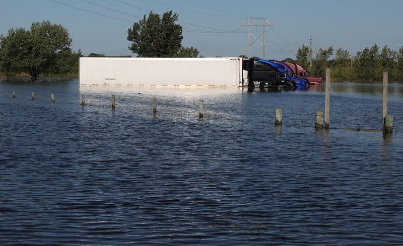
March 13-23: Catastrophic Flooding:
|
The worst flooding in decades, and in some locations the worst flooding on record occurred from the middle to latter part of March 2019. Many factors contributed to the disastrous flooding in the Spring. February through March saw bitterly cold temperatures and snowy conditions. The ground was frozen to a depth of 25 inches and the snow pack was widespread and deep, especially in the Loup River basin where the snow depth ranged from 10-17 inches. The prolonged cold weather led to excessive ice formation on rivers and creeks. Then, a potent storm system arrived, deepening across the Central Plains and producing widespread precipitation. The precipitation initially fell as rain for a couple of days, with some embedded thunderstorms. As the system progressed, a warm front lifted northward and allowed temperatures to surge into the 50s and 60s. Rain continued on the warm side of the system, but then changed to snow as Arctic air surged south on the cold side of the system. Intense winds accompanied the snow and combined to produce blizzard conditions before the system departed. The rain and warm, above freezing temperatures resulted in rapid snow melt, and due the frozen ground, the rain and snow melt was converted to runoff and created widespread flooding. The most significant and damaging flooding occurred north of the Platte River and included the Wood River, the entire Loup River system and the Cedar River. The rivers overflowed, lowland areas were inundated by floodwaters and looked like lakes. As increasing flows on area rivers broke up the ice in the rivers, ice jams occurred and large slabs of ice were deposited and piled up onto bridges and roadways. Widespread flash flooding occurred, requiring evacuations and water rescues. Water covered hundreds of gravel and paved roads, including state and federal highways, making them impassable. Dozens of bridges were washed out, primarily on county roads, but bridges on paved roads were also affected. Thousands of homes and businesses were damaged and flooding was extensive in Dannebrog, Pleasanton, Gibbon, Wood River and Alda. The flooding also impacted trains and the Union Pacific railroad tracks between Gibbon and Columbus were shut down for several days. Numerous rivers saw record crests and the impacts of the flooding was tremendous. As flood waters receded, pasture land and fields next to rivers were covered in inches of sand and silt. The flooding occurred in the middle of calving season and hundreds of calves perished, were stranded, or livestock carcasses floated away in the floodwaters. Disaster declarations were declared and preliminary estimates of damage were expected to exceed $1 billion. |
|
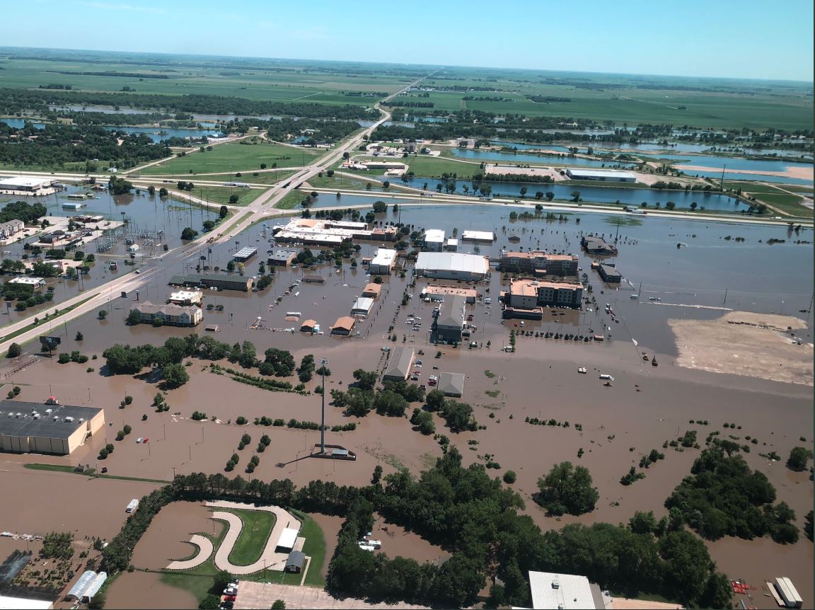
July 8-9th: Extreme Flooding (again)
|
Excessive rainfall due to training of thunderstorms (multiple rounds of storms) produced copious amounts of rainfall on July 8th and 9th, and was focused across Buffalo, Dawson, Gosper, Furnas, Harlan and Phelps counties. Some of the highest rainfall totals included: 10.65" southwest of Odessa, 8.88" in Loomis, 8.33" near Hildreth, 7.66" in Riverdale, 7.60" near Lexington, 7.41" north of Funk and 7.15" southwest of Ravenna. In addition, the city of Kearney measured 4-7" (highest on the west side of town). |
|
Tornadoes
May Tornadoes: May 17th and May 26-28
|
May 17th: A long-tracked supercell thunderstorm tracked northeast through portions of western Dawson County, producing three confirmed tornadoes and large hail of 2 inches in diameter. Two of the tornadoes were rated EF-1 and one tornado was rated EF-0. Two of the tornadoes narrowly missed the communities of Farnam and Cozad. |
|
Winter
February 23: Blizzard Conditions
|
A powerful low pressure system passed through the Central Plains on Saturday, Feb. 23, 2019, bringing several hours of blizzard conditions. Prior to the onset of blizzard conditions, most places saw a period of freezing drizzle that kicked in as early as the evening of the 22nd, resulting in some slick roads before snow ever started. Snow first developed over north central Kansas then quickly spread northeast during the early afternoon. North to northwest winds frequently gusted to 35 mph to over 40 mph and resulted in very poor visibility for several hours, along with considerable drifting of snow. Travel became treacherous on many local roadways, including Interstate 80, where several accidents occurred in Hamilton and York counties. At one point during the afternoon-evening, Interstate 80 was closed from Omaha to as far west as Lexington. Most areas southeast of roughly a York-Red Cloud-Stockton KS line saw the highest snowfall amounts of 6-10". |
|
November 26: Heavy Snow and Strong Winds just before Thanksgiving
|
A winter storm system brought significant snowfall and travel impacts to a large portion of Nebraska and portions of northern Kansas the Tuesday before Thanksgiving. Snow developed through the late morning from northwest Kansas up through central Nebraska. Throughout the winter weather event, a mix of sleet and freezing rain was observed at times on the southern edge of the main snow band. Warm ground temperatures caused some melting as snow fell, but most of central Nebraska still had slick and snow-covered roads by early afternoon. The heaviest band of snow developed and moved across the area roughly from mid afternoon through mid evening. Snow rates of 1" per hour were common, and rates were likely as high as 2" per hour at times. For example, the cooperative observer in Greeley, NE had around 5" of snow in roughly 4 hours between 3:30 and 7:30pm. Northwest winds also picked up quite a bit after 6 pm, and many locations saw 40-45 mph wind gusts, causing areas of blowing snow and low visibility. As a result, Interstate 80 was closed in both directions from Kearney to York for several hours Tuesday evening. By the time snow exited the area around midnight, many locations had seen 6-10 inches. The heaviest totals were centered near a line from Cambridge to Holdrege to Grand Island to Fullerton, NE. Amounts decreased significantly to the south and east, though. Areas southeast of a line from Phillipsburg, KS to Smith Center, KS to Hebron, NE generally saw less than 1" of snow. The snowfall broke the daily records for November 26th at both Grand Island and Hastings. These new record totals were 8.2" and 7.1" respectively. |
|
Office Events
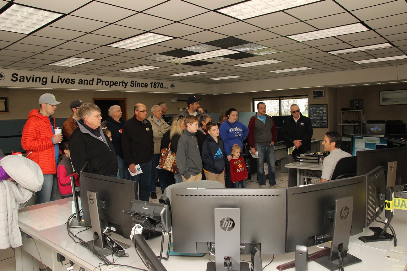
April 27: NWS Hastings Open House
|
For the first time in 25 years, NWS Hastings hosted an open house on April 27th. Despite cold and windy conditions, around 500 people braved the weather and visited our office. Open house activities included a summary of our office's mission and responsibilities, and a tour of the operations area. There, attendees learned about various tools we use to monitor and forecast the weather, including: Doppler radar, GOES East satellite, automated observations and weather forecast models. They were also shown various electronic equipment necessary to keep the office running and data flowing. Outside the office, other staff members presented on how to accurately measure and report rain, snow and hail. Other visual displayed included our "tornado in a box", along with a flood plain model used to show water absorption, runoff and the importance of flood plain management. |
|
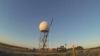
October 21-October 31: NWS Hastings Radar (KUEX) Upgraded
|
On October 21st, the NWS Hastings Doppler radar (KUEX) located at Blue Hill, NE was shut down for a major refurbishment project to replace the antenna pedestal. This was part of a multi stage project known as SLEP (service life extension program), that is modernizing and refurbishing the NEXRAD fleet of radars.
In order for the radome removal and pedestal replacement to occur safely, weather conditions had to cooperate. Any wind over 18 mph was potentially too high and dangerous for the operation to proceed, especially if gustiness was occurring. When it was initially time to replace the radome, gusts exceeded 27 mph, so the replacement was delayed until the following evening when winds decreased ahead of an approaching front. Even with the slight delay in replacing the radome, the project was finished and final testing completed on October 31st, well-ahead of the projected return date of November 11th. |
|
|
Climate - 2019 Weather Extremes
(Data from NWS Cooperative Observers and CoCoRaHS/NeRain observers)
Hottest Temperatures of 2019 (all occurred in July)
Coldest Temperatures of 2019 (most occurred in early-March)
Highest 2019 ANNUAL Precipitation ("normal" annual precip generally ranges from 23-30")
Highest Calendar-Month Precipitation
Highest 24-hour Rain Totals (for a 7am-7am period...all reported on JULY 9)
Highest Calendar-Month Snowfall
Highest Storm-Total Snowfall
Nebraska Tri-Cities Extremes and Totals (Grand Island, Hastings, and Kearney airports)
Please visit the following sites for a wealth of local climate information:
- NOWData....official temp/precip/snow data for any NWS observation site in our coverage area
- Daily/Monthly/Annual Precipitation Maps (maintained by NWS Hastings)
- 24 to 72 hour Observed Snowfall Maps (maintained by NWS Hastings)
- NWS Hastings Local Climate Page (various additional weather/climate info, including detailed monthly stories)
- High Plains Regional Climate Center (HPRCC)...information for the entire High Plains region (not just our coverage area)