
A widespread heat wave will peak over the South and East today, with several dozen temperature records expected along the East Coast. Heat should begin to ease this weekend in the Northeast, while hazardous heat continues over the South. Severe thunderstorms capable of damaging winds are possible across parts of the Appalachians, Mid Atlantic, and Northeast this afternoon and evening. Read More >
 |
Now that the 2020-21 snowfall season is well-underway (parts of our coverage area have already measured over 10"!), it's time to rewind and examine last snow season (2019-20) for our 30-county coverage area. As covered in more detail below, the "basic theme" of last winter was a disparity between our north-northwest counties (snowier-than-average) and our south-southeast counties (below-average snowfall).
Below are various graphics and tables that outline seasonal totals, departures from normal/average etc. for the 2019-2020 season. Before continuing though, and in order to give last season's totals some perspective, official 30-year normals/averages for our area are:
"Normal"/average seasonal snowfall within our coverage area (based on 1981-2010 NCEI data):
** Note: You can access daily and seasonal local snow total maps (updated DAILY) at this page: https://www.weather.gov/gid/Snow
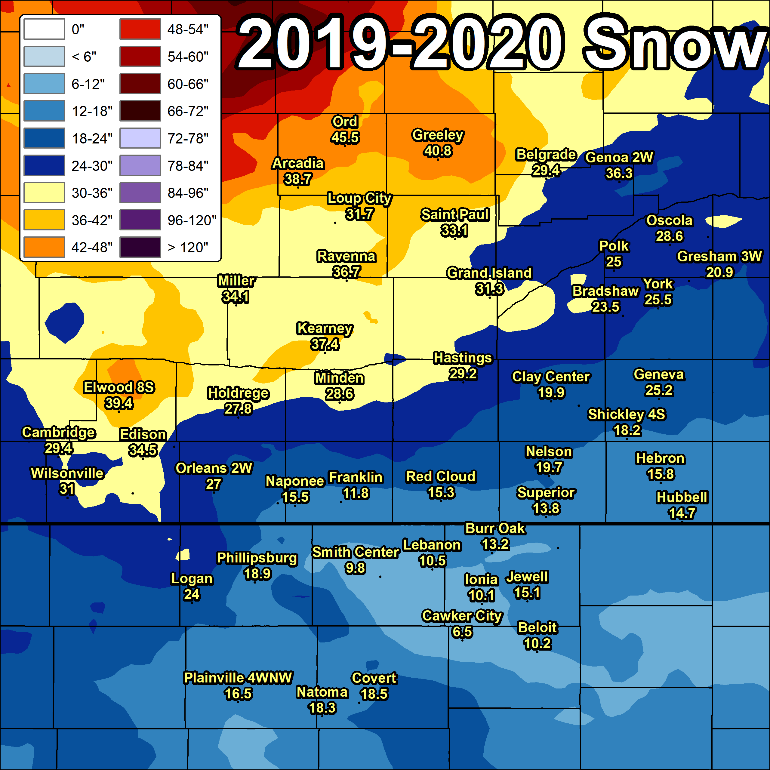
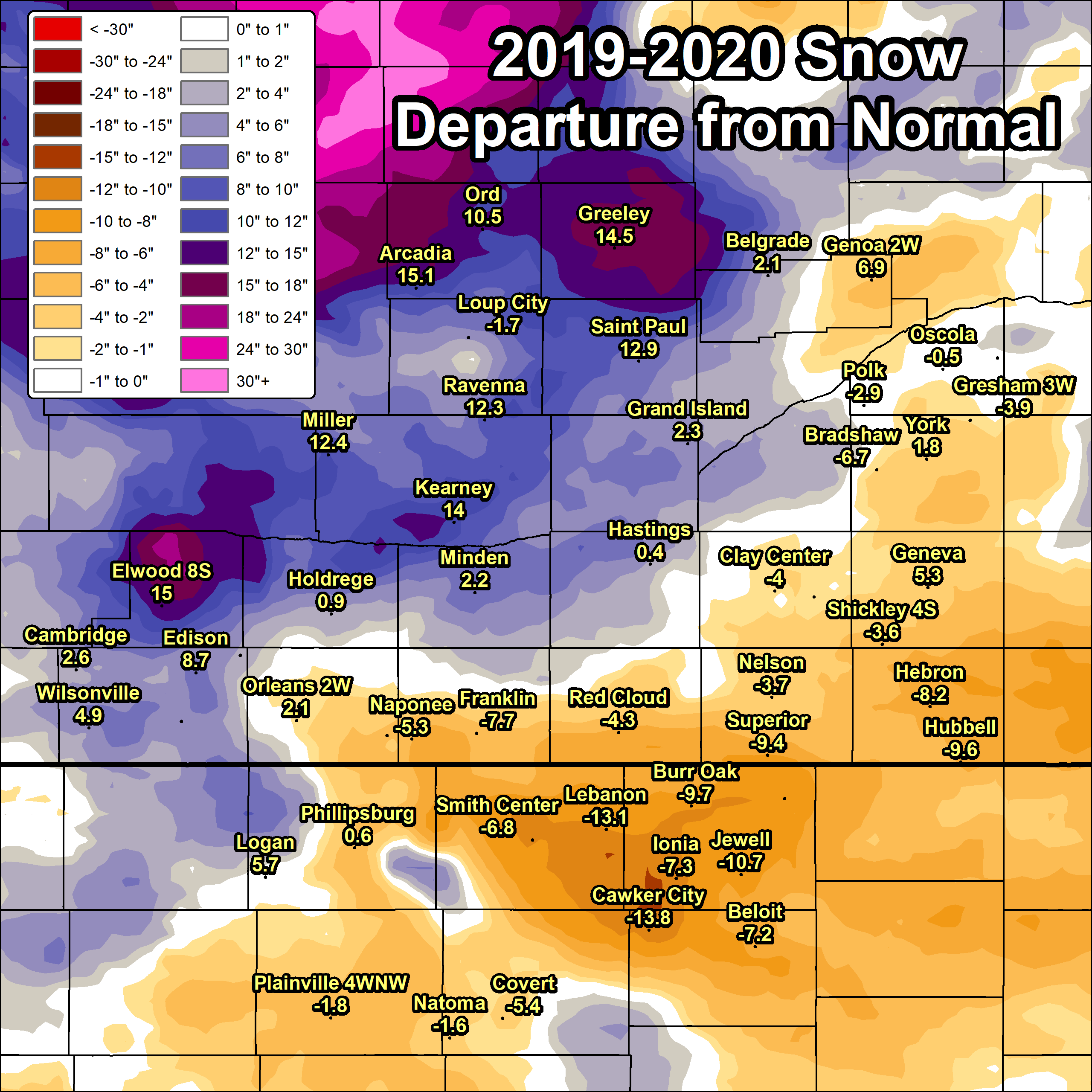
South Central Nebraska/North Central Kansas
2019-20 Seasonal Snow and Departure From Normal
(click image to enlarge)
 |
 |
| 2019-20 Snow Season Totals | 2019-20 Snow Departure From Normal |
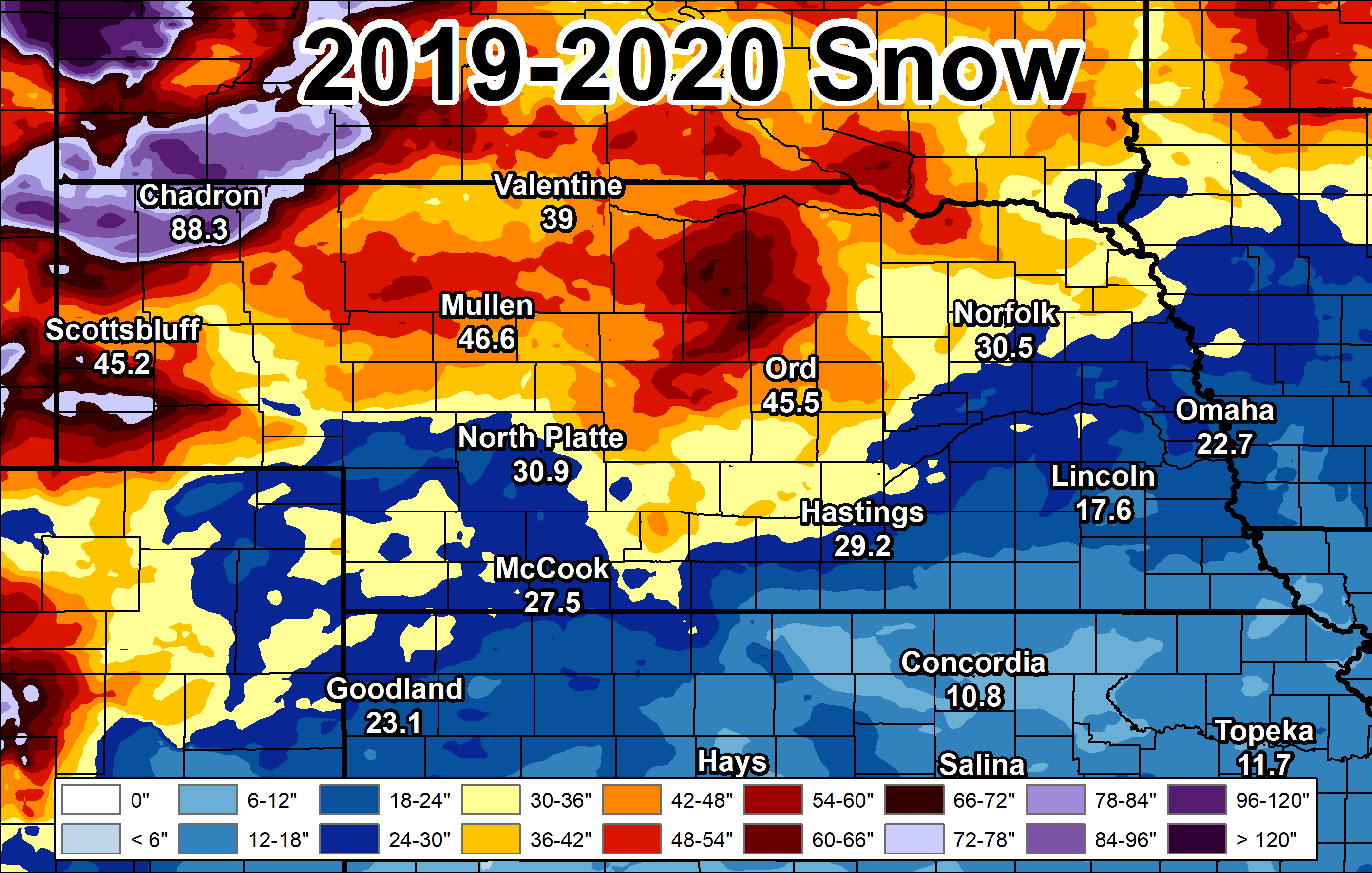
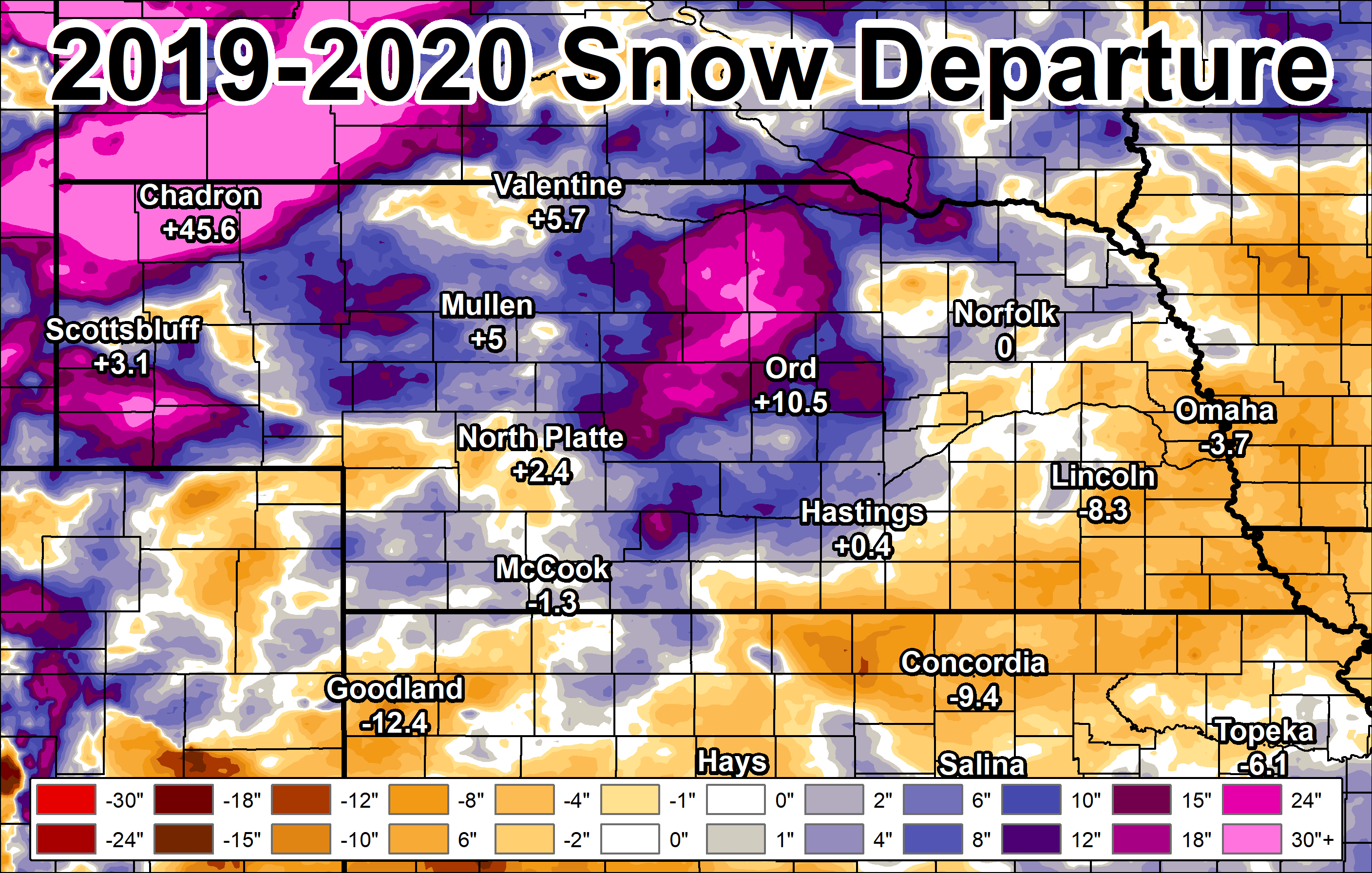
Regional (Central Plains)
2019-20 Seasonal Snow and Departure From Normal
(click image to enlarge)
 |
 |
| 2019-20 Snow Season Totals | 2019-20 Snow Departure From Normal |
WINTER 2019-2020 SOUTH CENTRAL NEBRASKA
COOPERATIVE OBSERVER SNOWFALL
The highest reported amount under each month indicated in BLUE, the lowest amount in RED.
T* indicates hail was reported during the month.
| Station | Sep | Oct | Nov | Dec | Jan | Feb | Mar | Apr | May | Season |
| Arcadia 2W | 0.0 | T | 8.8 | 16.1 | 2.5 | 3.0 | 5.0 | 3.3 | T* | 38.7 |
| Beaver City | 0.0 | T | 8.2 | 6.4 | 2.4 | 7.5 | 3.0 | T | 0.0 | 27.5 |
| Belgrade | 0.0 | 0.4 | 8.0 | 6.0 | 3.0 | 1.0 | 6.0 | 5.0 | 0.0 | 29.4 |
| Blue Hill 4SW | 0.0 | 1.6 | 6.5 | MSG | 3.4 | MSG | MSG | MSG | 0.0 | MSG |
| Bradshaw | T | 1.1 | 4.2 | 2.6 | 3.7 | 1.0 | 5.8 | 5.1 | 0.0 | 23.5 |
| Cambridge | T | 2.1 | 10.2 | 4.8 | 1.3 | 3.5 | 7.0 | 0.5 | 0.0 | 29.4 |
| Lexington 6SSE (Canaday) | 0.0 | 1.5 | 7.8 | 8.2 | 0.5 | 4.2 | 0.2 | 1.0 | 0.0 | 23.4 |
| Clay Center 6ESE | 0.0 | 1.1 | 3.7 | 1.7 | 5.4 | 1.0 | 4.0 | 2.4 | 0.0 | 19.3 |
| Clay Center | 0.0 | 1.0 | 7.0 | 1.7 | 3.7 | 0.5 | 3.5 | 2.5 | 0.0 | 19.9 |
| Edison | 0.0 | 1.0 | 9.0 | 6.0 | 0.5 | 10.0 | 7.0 | 1.0 | 0.0 | 34.5 |
| Elwood 8S | 0.0 | 1.3 | 9.0 | 8.5 | 1.5 | 8.6 | 9.0 | 1.5 | 0.0 | 39.4 |
| Franklin | 0.0 | 0.5 | 3.5 | 2.4 | T | 1.0 | 4.4 | T | 0.0 | 11.8 |
| Geneva | 0.0 | 1.5 | 3.5 | 4.0 | 7.2 | 1.5 | 5.5 | 2.0 | 0.0 | 25.2 |
| Genoa 2W | 0.0 | 0.3 | 9.0 | 5.8 | 7.5 | 0.7 | 7.0 | 6.0 | 0.0 | 36.3 |
| Grand Island Airport | 0.0 | 1.6 | 10.0 | 5.0 | 4.3 | 2.0 | 4.5 | 3.9 | 0.0 | 31.3 |
| Greeley | 0.0 | T | 9.8 | 12.8 | 4.5 | 1.8 | 6.4 | 5.5 | 0.0 | 40.8 |
| Gresham 3W | 0.0 | T | 3.1 | 1.4 | 7.4 | 1.0 | 3.0 | 5.0 | 0.0 | 20.9 |
| Harlan County Lake | 0.0 | 1.0 | 7.1 | 5.0 | 0.5 | 2.5 | 0.5 | T | 0.0 | 16.6 |
| Hastings NWS | 0.0 | 1.2 | 8.1 | 5.9 | 4.1 | 2.1 | 5.3 | 2.5 | 0.0 | 29.2 |
| Hebron | 0.0 | 1.3 | 1.0 | 1.8 | 6.4 | 0.4 | 3.8 | 1.1 | 0.0 | 15.8 |
| Holdrege | 0.0 | 1.0 | 7.7 | 7.0 | 1.1 | 3.0 | 6.0 | 2.0 | 0.0 | 27.8 |
| Hubbell | T | 1.6 | 1.1 | 2.7 | 6.9 | 0.4 | 3.0 | 2.0 | 0.0 | 14.7 |
| Kearney Airport | 0.0 | 1.7 | 9.0 | 12.8 | 1.8 | 2.9 | 6.2 | 3.0 | 0.0 | 37.4 |
| Loup City | 0.0 | 0.2 | 11.2 | 11.5 | 2.9 | 0.9 | 4.0 | 1.0 | 0.0 | 31.7 |
| McCool Junction | MSG | MSG | MSG | MSG | MSG | MSG | MSG | MSG | MSG | MSG |
| Miller | 0.0 | 1.6 | 9.7 | 11.5 | 1.3 | 2.6 | 4.0 | 3.4 | T* | 34.1 |
| Minden | 0.0 | 1.0 | 7.5 | 8.5 | 1.3 | 2.0 | 7.3 | 1.0 | 0.0 | 28.6 |
| Naponee | 0.0 | 1.4 | 4.7 | 5.4 | T | T | 4.0 | 0.0 | T* | 15.5 |
| Nelson | 0.0 | 2.0 | 3.5 | 1.8 | 6.5 | 0.7 | 4.0 | 1.2 | 0.0 | 19.7 |
| North Loup | 0.0 | 0.2 | 8.1 | 15.8 | 5.0 | 1.3 | MSG | MSG | MSG | MSG |
| Orleans 1W | 0.0 | 1.9 | 10.8 | 4.6 | 1.2 | 3.4 | 4.4 | 0.7 | T* | 27.0 |
| Ord | 0.0 | T | 8.6 | 16.3 | 4.8 | 3.8 | 7.0 | 5.0 | T* | 45.5 |
| Osceola | 0.0 | 1.4 | 6.6 | 2.8 | 5.7 | 0.8 | 5.4 | 5.9 | 0.0 | 28.6 |
| Oxford 6NNW | 0.0 | 1.2 | 8.5 | 6.7 | 0.4 | 5.8 | 5.8 | 0.9 | 0.0 | 29.3 |
| Polk | 0.0 | 0.5 | 5.9 | 4.0 | 6.1 | 1.0 | 3.5 | 4.0 | 0.0 | 25.0 |
| Ravenna | 0.0 | 1.5 | 9.0 | 12.5 | 4.0 | 1.2 | 5.6 | 2.9 | 0.0 | 36.7 |
| Red Cloud | 0.0 | T | 1.5 | 3.1 | 4.6 | 0.6 | 5.0 | 0.5 | 0.0 | 15.3 |
| St. Paul | 0.0 | 0.4 | 11.0 | 8.6 | 4.1 | 1.9 | 4.9 | 2.2 | 0.0 | 33.1 |
| Shelby 3NE | 0.0 | 1.6 | 7.5 | 2.6 | 5.7 | 0.7 | 7.2 | 4.8 | 0.0 | 30.1 |
| Shickley 4S | 0.0 | 1.0 | 2.0 | 1.3 | 6.5 | 0.4 | 4.0 | 3.0 | 0.0 | 18.2 |
| Superior | 0.0 | 1.0 | 2.5 | 1.9 | 4.5 | 0.8 | 2.4 | 0.7 | 0.0 | 13.8 |
| Wilsonville | 0.0 | 3.0 | 12.0 | 4.5 | 1.5 | 5.0 | 4.0 | 1.0 | 0.0 | 31.0 |
| York 3N | 0.0 | 1.0 | 4.5 | 2.6 | 5.1 | 1.8 | 4.6 | 5.9 | 0.0 | 25.5 |
WINTER 2019-2020 NORTH CENTRAL KANSAS
COOPERATIVE OBSERVER SNOWFALL
The highest reported amount under each month indicated in BLUE, the lowest amount in RED.
T* indicated hail was reported during the month.
| Station | Sep | Oct | Nov | Dec | Jan | Feb | Mar | Apr | May | Season |
| Beloit | 0.0 | T | 3.0 | 4.0 | 2.2 | 1.0 | T | 0.0 | 0.0 | 10.2 |
| Burr Oak 1N | T* | 2.1 | 2.4 | 3.0 | 2.9 | 0.6 | 1.5 | 0.7 | 0.0 | 13.2 |
| Cawker City | 0.0 | T | 2.5 | 3.0 | T | 0.5 | 0.5 | T | 0.0 | 6.5 |
| Covert Rural | 0.0 | 1.5 | 5.4 | 5.1 | 1.0 | 5.5 | 0.0 | 0.0 | 0.0 | 18.5 |
| Ionia | 0.0 | 1.0 | 2.3 | 1.9 | 3.0 | 0.3 | 1.5 | 0.1 | 0.0 | 10.1 |
| Jewell | 0.0 | 1.0 | 2.0 | 5.0 | 5.0 | 1.1 | T | 1.0 | 0.0 | 15.1 |
| Kirwin Dam | 0.0 | 0.5 | MSG | 2.3 | T | 9.0 | 0.0 | 0.0 | 0.0 | MSG |
| Lebanon | 0.0 | 1.5 | 1.4 | 2.7 | 3.4 | 0.3 | 1.0 | 0.2 | T* | 10.5 |
| Logan | 0.0 | 2.0 | 7.0 | 2.5 | 1.5 | 9.0 | 2.0 | T | T* | 24.0 |
| Lovewell Dam | 0.0 | 1.0 | T | 1.1 | 5.7 | 1.0 | 0.0 | 0.5 | 0.0 | 9.3 |
| Natoma | 0.0 | 0.5 | 6.5 | 4.8 | 2.5 | 3.5 | 0.5 | 0.0 | 0.0 | 18.3 |
| Phillipsburg | 0.0 | 1.5 | 4.2 | 2.9 | 0.3 | 8.5 | 1.5 | T | 0.0 | 18.9 |
| Plainville 4WNW | 0.0 | 1.0 | 5.7 | 3.2 | 1.0 | 4.6 | 1.0 | T | 0.0 | 16.5 |
| Smith Center | 0.0 | 0.5 | 2.4 | 2.9 | 1.9 | 0.8 | 1.3 | T | 0.0 | 9.8 |
| Webster Dam | 0.0 | 0.2 | MSG | 2.0 | 1.0 | 1.5 | 0.0 | 0.0 | 0.0 | MSG |
The 2019-2020 snowfall season was highlighted/defined by the following points:
Within our 24 South Central Nebraska counties (per NWS observers): the highest 2019-2020 seasonal snow totals were in our far northern coverage area, featuring 45.5" at Ord and 40.8" in Greeley, while the lowest totals (near the Kansas border) included 11.8" at Franklin and 13.8" in Superior.
Within our six North Central Kansas counties (per NWS observers): the highest 2019-2020 seasonal totals featured 24.0" at Logan and 18.5" near Covert (rural Osborne County), while the lowest amounts included merely 6.5" at Cawker City and 9.8" in Smith Center.
In the Nebraska Tri Cities: official seasonal totals included: Kearney 37.4" (14" above normal)...Grand Island 31.3" (2.3" above normal)...Hastings 29.2" (0.4" above normal). Purely coincidentally, the Hastings total happened to be the exact same as the previous season!
The EARLIEST MEASURABLE snow within our coverage area occurred between Oct. 28-30 (as much as 3" at Wilsonville) and the LATEST MEASURABLE snow occurred on April 16 (as much as 5.9" near York) .
These Were a Few of Our "Bigger" Snow Events From The 2019-20 Season (click red links for detailed stories)...
December 26-27, 2018: Winter Storm Brings Heavy Snow to Mainly Northern/Western Areas
January 11-12, 2019: 4-8" of Heavy, Wet Snow Targets Southeast Counties
February 23, 2019: Blizzard Impacts Much of the Southeast Half of the Area
 |
Media use of NWS Web News Stories is encouraged! Please acknowledge the NWS as the source of any news information accessed from this site. |
|

