
Wildfire smoke will push into the Midwest, worsening air quality. A frontal system brings severe storms from the Northern Plains to the Mid‑Atlantic the next few days. Heavy Gulf Coast rain is possible as Tropical Depression Two has formed, while monsoonal storms persist in the Southwest with heavy rainfall. Hazardous heat expands from the Plains into the Lower Mississippi Valley. Read More >
Top Weather Events of 2018
|
With 2018 in the books, it's time to take a look back and review some of the significant weather events which occurred across our 30-county coverage area of south central Nebraska and north central Kansas. The events that made our top picks include varying weather extremes, from winter weather to severe weather. Severe weather in 2018 was a bit of mixed bag across the area. Most people probably won't remember the 13 tornadoes which impacted the area, primarily because these tornadoes were generally weak in nature and caused limited damage. What may stand out more is the combination of damaging winds and hail. A staple of every season, this past season brought particularly damaging hail events to Phelps, Furnas, Hamilton, York and Howard counties. In those counties, large amounts of crops were literally "mowed down" by the wind and hail. Fortunately, no injuries were reported this severe weather season, and once the summer season passed, the year ended with little to no severe weather in the fall Later in the year, "winter" showed up early for many. October 14th featured one of the earlier snow events on record for parts of the area, which was then followed by a series of snow events in November and early December. The multiple rounds of snow totaled 4-10 inches across the area which were above-normal snow totals for November. Temperatures were overall colder-than-normal during the fall, running 2-4 degrees below normal in October and 3-5 degrees below normal in November. |
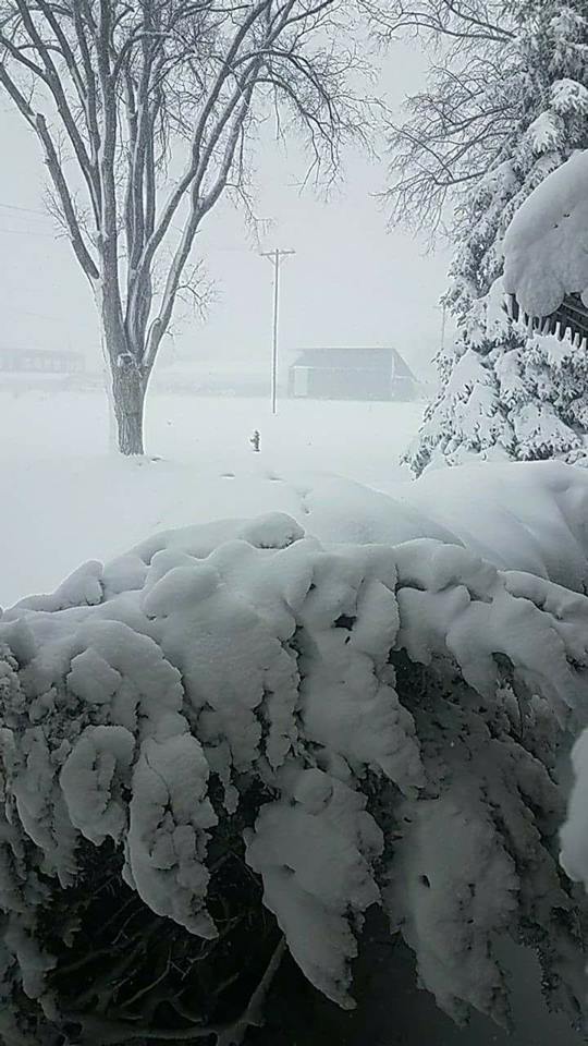
 January 21-22, 2018 Winter Storm. Photo by Jennifer Mohn Kenny (Northwest of Central City, NE)
|
Blizzard Arrives: January 21-22nd
A potent low pressure system crossing the Central Plains brought heavy snow and blizzard conditions January 21st-22nd. The heaviest snow fell north of Interstate 80 where amounts ranged from 6-14 inches, including 14" at Belgrade, 13.8" at St. Paul. 12.1" at Greeley, 10.5" in Osceola, 10.3" at Ord and 7.4" at the Grand Island airport. The snow was accompanied by strong northwest winds of 30-40 mph with gusts over 50 mph, which produced whiteout or blizzard conditions at times. Travel was treacherous due to the blowing and drifting snow and sporadic power outages and a few road closures also occurred.
Grand Island set new Jan. 22 records for both precipitation (0.86 inch) and snowfall (7.4 inches).
 |
 |
 |
 |
| Arcadia, NE Photo by Scott Philbrick |
St. Paul, NE Photo by Lori Patsios |
Central City, NE Photo by Jen Krupa |
Silver Creek, NE Photo by Megan Renee |
No Fooling - Heavy Snow on April 1st, Easter Sunday
An upper level disturbance sliding across the Central Plains produced a narrow band of heavy snow late Saturday night and into the first half of the day of Easter Sunday (April 1, 2018). The heaviest snowfall set up in a band approximately 20-30 miles wide and was generally oriented along and south of Highway 6 in Nebraska. Within the main snow band, totals of 6-11" were common, while outside of the snow band to the north and south, amounts were significantly lower.
 |
 |
 |
 |
| Pauline, NE Photo by Jesse Wirtes |
Johnson Lake, NE Photo by Kathy Larson |
Axtell, NE Photo by Shawn Thames |
Storm Total Snowfall Map |
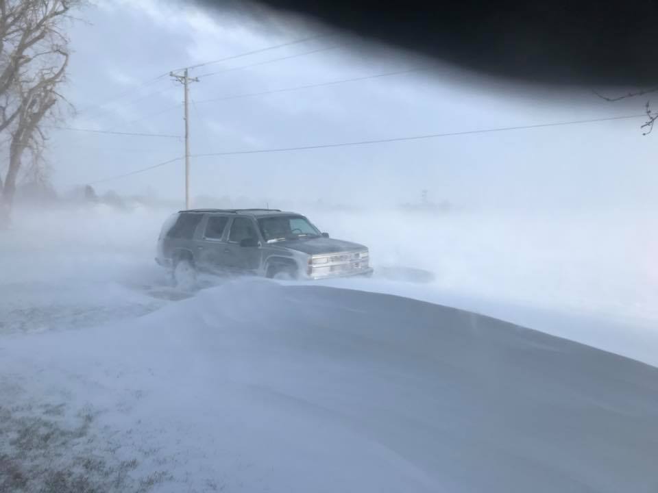
Another Blizzard! Snow and Ice April 13-14th
An intense spring storm system brought a return of impactful winter weather conditions the middle of April, with ice, snow, wind and blizzard conditions. Precipitation began as rain, but changed over ice and snow as cold air arrived. Snow amounts were not as high as expected, however a swath of heavier snowfall of 2.5 inches to 5.5 inches fell in a corridor from Holdrege to Kearney to Ord, NE, with even higher amounts falling across western Nebraska. Locations east of Highway 281 saw much lower snow totals closer to one inch. The snow combined with intense north winds of 30 to 40 mph with gusts over 50 mph to produce blizzard conditions. The highest wind gust of 64 mph was measured at the Ord Airport, with 63 mph recorded at Hastings and northwest of Oxford, 59 mph at Grand Island and 58 mph at Kearney. Travel was treacherous due to the white-out conditions and Interstate 80 was closed from Grand Island to locations to the west. Freezing rain caused significant ice accumulations of one quarter to one half of an inch north of the Tri-Cities, with the impacts of the ice and snow magnified by the intense winds. The Region 26 communications tower north of Ord (which also housed the NOAA Weather Radio transmitter) collapsed during the storm, and the weather radio broadcast remained off-air or on low power for several months. Numerous power poles were damaged during the storm, which caused widespread power outages. Monetary damages from the storm totaled well over a million dollars. While the storm arrived over a weekend, from a Friday afternoon through Saturday, the storm impacted several school events ranging from sporting activities to proms.
 |
 |
 |
 |
| Lexington, NE Photo by KRVN |
Damaged Power Poles in Greeley County, NE Photo by Mike Timmons |
Accidents near the Tri-Cities in NE Photo by Nebraska State Patrol |
North of Ord, NE photo by Scott Philbrick |
Tornadoes, Hail and Wind: May 1st
A stalled frontal boundary focused thunderstorms during the afternoon and evening on May 1st. Storms rapidly developed along the front and quickly became severe, producing large hail to the size of golf balls (1.75" in diameter) and hen eggs (2.00" in diameter) in the Shelby to Hastings and Clay Center, NE areas to Hunter, KS. Severe thunderstorm wind gusts of 60 mph were reported at Burr Oak and near Hunter, KS. The first tornadoes of the year touched down, including ones at Doniphan, northwest of Aurora, north of Chester, NE and south of Beloit, KS (all were rated EF-0). The Doniphan tornado set down south of town at 4:50 pm and tracked north nearly two miles before lifting. The tornado struck and destroyed an outbuilding on the south edge of Doniphan, scattering debris to nearby homes which subsequently damaged a roof, windows, garage doors and soffits. The tornado northwest of Aurora was a nearly stationary landspout tornado which overturned a center pivot. This tornado was visible from Interstate 80 and Highway 34 and was witnessed by many people. The tornado north of Chester, NE was captured on a GOPRO video camera by a local farmer. This tornado touched down in an open field and did not produce significant damage. In north central Kansas, the tornado south of Beloit set down briefly in an open field and did not produce any known damage. In addition, thunderstorms also produced a swath of heavy rainfall of three to five inches in the Hunter and Tipton areas of north central Kansas, causing flooded roads.
 |
 |
 |
 |
| Doniphan, NE Tornado photo by Terrell Bruce |
Tornado NW of Aurora, NE Photo by Holly Shada Johnson |
Hail in Hastings, NE photo by Jamy Schultz |
Wind damage 6NE Luray, KS photo by NWS staff |
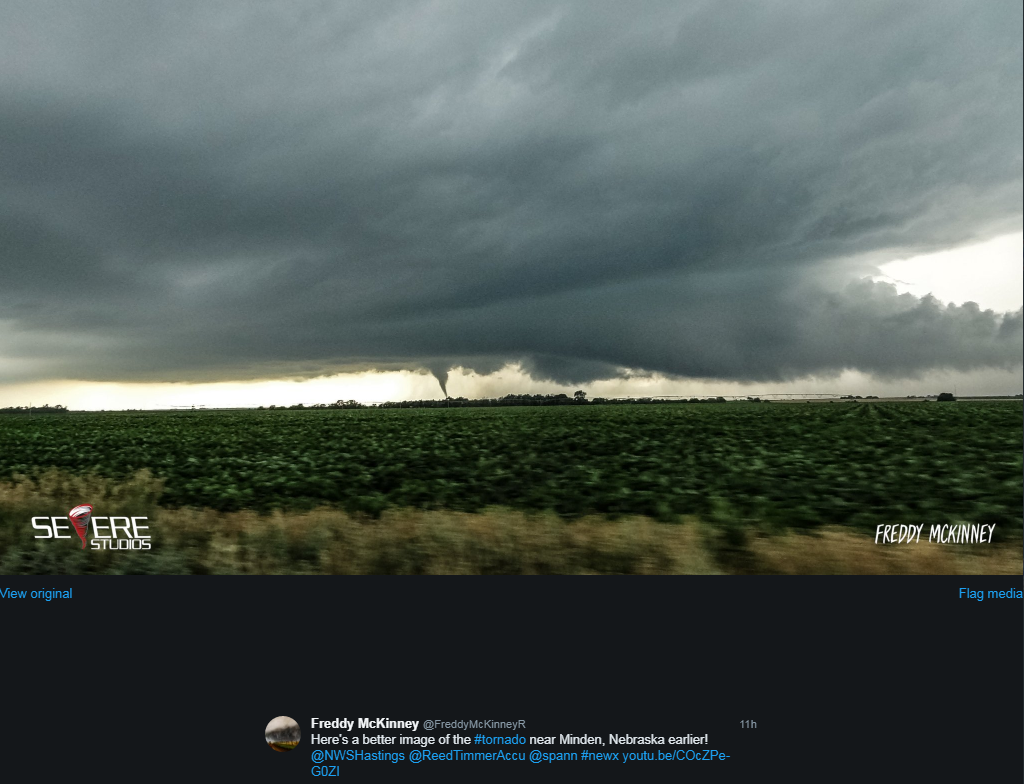
June 30 Severe Weather: Tornadoes, Hail, Wind
An upper level disturbance and surface frontal boundary set the stage for severe weather on June 30th. Two discrete supercell thunderstorms produced intense, crop-damaging hail and two EF-0 tornadoes in Phelps county (west and northwest of Wilcox, NE). The storms produced large hail of golf ball to baseball size and 60-80 mph wind gusts which caused extensive crop damage in the Arapahoe, Loomis, Axtell and Minden areas. Later in the evening and farther east, additional thunderstorms produced 60-80 mph wind gusts, with damage in primarily Clay, Fillmore and Thayer Counties including: downed trees and a destroyed carport and hog shed.
 |
 |
 |
 |
| Tornado near Wilcox, NE photo by Brent Artz via social media |
Hail in Axtell, NE Photo by Spencer Quigley |
Downed trees near Milligan, NE photo by Wade Sluka via social media |
Tornado southwest of Minden, NE photo by Freddy McKinney via social media |
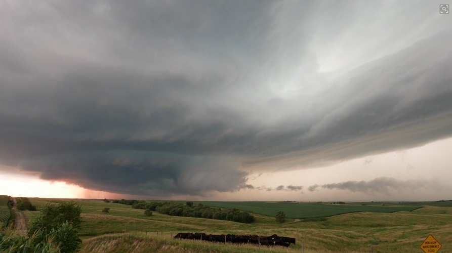
July 18th: More Large Hail
A supercell thunderstorm developed in the vicinity of a warm frontal boundary and produced very large hail to the size of baseballs as it moved southward across Hazard (Sherman County) and into Buffalo and Kearney Counties. Although this was a damaging storm, its structure was picturesque, with people taking pictures of the storm as far away as Harlan County Lake. In addition, this storm put on a spectacular lightning show visible for miles around. Fortunately, this storm did not produce any tornadoes, but crop damage from golf ball to baseball size hail was fairly extensive along a narrow swath from near Hazard, southward to between Kearney and Gibbon.
 |
 |
 |
 |
| Hail in Hazard, NE photo by Dan Patterson |
Hail in Hazard, NE Photo by Dawna Moore |
Crop damage 5NW of Pleasanton, NE photo by Heidi Erickson Riessland |
Thunderstorm near Hazard, NE photo by Matt Ziebell |
August 6th: Wind, Hail and a Tornado
A pair of supercell thunderstorms produced very large hail up to two inches in diameter, damaging wind gusts of 60 to 75 mph and an EF-1 tornado during the evening of August 6th. The tornado touched down in northwest York County around 7:45 pm and tracked east-southeast for less than two miles, causing minor damage to a home and also damaging several grain bins and snapping a few large trees. The largest hail reports (two inches in diameter) originated from the Bradshaw and Alda areas. In addition, golf ball size hail occurred near Benedict and Waco, and much of the city of York saw a few minutes of hail to at least half dollar size. A thunderstorm wind gust of 60 mph was measured at the York airport and stronger wind gusts were estimated at 75 mph at times. Crop damage was extensive along the storm's path from central Merrick County into northeast Hamilton County into York County.
 |
 |
 |
 |
| Thunderstorm near Waco, NE photo by Freddy McKinney |
Hail and Crop Damage near Archer, NE Photo by Todd Weller |
Large Hail in Archer, NE photo by Natalie Stander |
Large hail near Utica, NE photo by Drew Erks |
October, November, December: Early Season Snow & Weekend Winter Weather Systems
An unusually-early measurable snow event arrived with a strong cold front on Sunday, October 14th. The highest snow totals of 3-7 inches set up along a southwest to northeast band in the Red Cloud, Clay Center, Superior, Geneva, Hebron and York/Waco areas. Outside of the main snow band, snow amounts ranged from a dusting to around an inch and a half. Hastings received 1.1 inch of snow and this was the 4th-earliest snowfall of 1-inch or more on record; Grand Island received 1.5 inch of snow and it was the 5th-earliest on record.
In November, above normal snowfall was the big story, with multiple snow events and many areas (including the Nebraska Tri-Cities) receiving roughly double the amount of normal snowfall. Grand Island tallied 7.9 inches, notching its snowiest November since 1983. Hunter, KS saw 12.7 inches of snow, Plainville, KS picked up 12.1 inches and Holdrege received 10.5 inches. On November 8th, 1-3 inches of snow fell in a corridor between Interstate 80 and Highway 6 and also across north central Kansas, with locally higher amounts of at least 5-7" targeting mainly parts of Gosper/Phelps/Kearney counties. November 17th saw 1-2 inches of snowfall across the area, which combined with gusty north winds to produce some travel impacts. November 25th (the weekend after Thanksgiving) saw a high-impact wind and snow event. Blizzard or near-blizzard conditions slammed north central Kansas into portions of southern Nebraska. Snow totals of 4-7" were common, whipped by 40-50 mph winds. Sadly a 37-year old woman who apparently wandered from her car during the height of blizzard conditions in Mitchell County, KS was found dead two days later near Waconda Lake.
The weekend of December 1st saw the third consecutive weekend of wet, wintry weather conditions. Widespread rain developed ahead of the snow with many areas picking up 1 to 2 inches of rainfall. Grand Island measured 1.51" of precipitation on December 1st, which set a new daily record amount. Hastings received 1.29", also setting a new daily record. Snowfall was less than anticipated due to more precipitation falling as rain than snow. However, a swath of heavier snow of 2-6" fell from the Holdrege to Ord and Greeley areas, and to the south from Superior to Mankato, KS to southwest of Beloit, KS. Despite the overall-less-than-expected snowfall, Grand Island still set a new daily record snow total of 1.6 inches December 1st.
 |
 |
 |
 |
| October 14th Snow - Waco, NE photo by Bert Smith |
November 8th Snow - Holdrege, NE Photo by Steve Schadegg |
November 24-25th Snow - Superior, NE Photo by Donald Tyler |
December 1st Snow - Smith Center, KS photo by Kathy White |
After-Christmas Storm Produces Widespread Rain Followed by Snow & Strong Winds: December 26th and 27th
Just after the Christmas Holiday, a storm system crossed the Central Plains producing widespread rainfall of at least one inch, with several locations picking up over two inches of rain. The heavy rainfall of 1.42 inches at Grand Island on December 26th and 1.41 inches at Hastings, both set new daily rainfall records. A cold front arrived later that night, with temperatures dropping below freezing and causing a "flash freeze" as wet outdoor surfaces and roads quickly froze. Multiple bands of heavy snow also developed early Thursday morning (December 27th) and continued through the day. The heaviest band of snow set up roughly from Cambridge to Lexington to Greeley, NE. When coupled with northwest wind gusts of 40 to 50 MPH, many locations saw whiteout conditions for several hours. This combination of drifted roads and poor visibility led to closures along Interstate 80 from Grand Island west to North Platte, impacting post-holiday travel. The strong winds led to scattered power outages across the area as well. Even areas that received minimal snowfall (1-2") had issues with poor visibility thanks to the long-lived intense winds.
 |
 |
 |
 |
| 10 NW of Kearney, NE photo by Jake Petr |
Cozad, NE Photo by Mrs. Stortenbecker |
Holdrege, NE Photo by Todd Veal |
Cambridge, NE photo by James McGowen |
2018 Weather Extremes (from a combo of official NWS observations and CoCoRaHS/NeRAIN observers):
Hottest temperatures of 2018 (all occurred in mid-late June)
Coldest temperatures of 2018 (all occurred NEW YEAR's DAY)
Highest 24 hour rain totals (most sites report for a 7AM-7AM period)
Highest 48-hour snowfall totals - all occurred during the Jan. 22 storm (most sites report for a 7AM-7AM period)
Nebraska Tri-Cities Extremes and Totals (Grand Island, Hastings, and Kearney airports)
 |
| 2018 Total Precipitation (click to enlarge) |
Please see our Local Climate Page for additional weather and climate information, including detailed MONTHLY stories.
 |
Media use of NWS Web News Stories is encouraged! Please acknowledge the NWS as the source of any news information accessed from this site. |
|


