 A Review of the Top Weather Events in 2015
Here are our top picks for weather events in 2015 which impacted the NWS Hastings coverage area (encompassing 30 counties in south central Nebraska and north central Kansas). The events are listed in chronological order.
January 7th: Highest Sea Level Pressure Record Set at Grand Island
An arctic high pressure system settled onto the Central Plain on January 7th, and the strength of the high pressure system reached 1056.9 millibars around mid day at the Central Nebraska Regional Airport in Grand Island. This pressure reading set a new all time high at Grand Island, breaking the previous record of 1054.5 millibars set on December 24th, 1983.
 |
| Surface analysis at noon on January 7, 2015 |
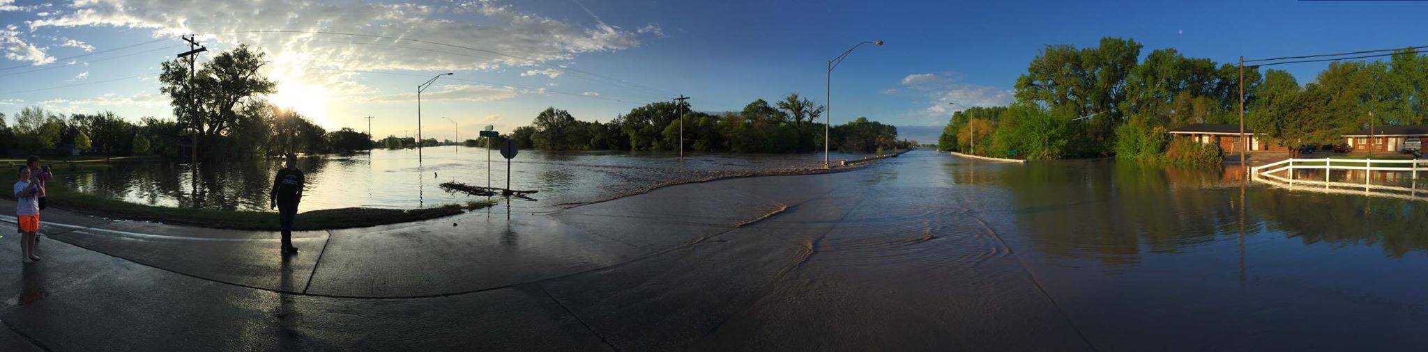
Floodin in Hebron. Photo by Shevin Solomon
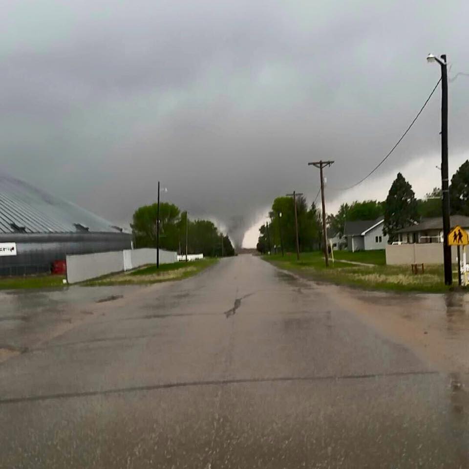
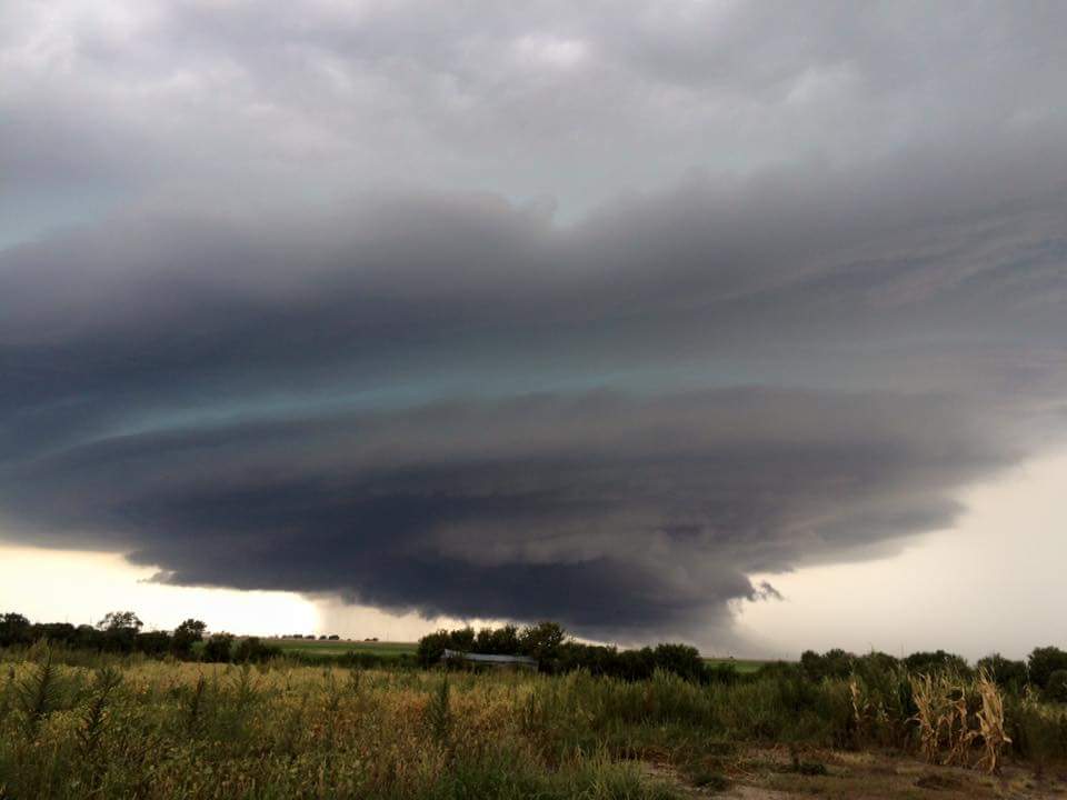
May 6th: Severe Weather with 11 Tornadoes & Record Rainfall
An outbreak of severe weather occurred on May 6th beginning early in the afternoon and continuing through the evening, as a strong upper low pressure system crossed the Central Plains. A total of eleven tornadoes were confirmed, with the strongest tornadoes (three of the tornadoes) rated EF2 on the Enhanced Fujita scale. In addition to the tornadoes, intense rainfall accompanied the thunderstorms and a corridor of heavy rainfall of 5 to over 10 inches of rain fell across much of Thayer and southeast Nuckolls Counties in Nebraska, and in northwest Jewewll County in Kansas. A Nebraska rainfall observer reported 10.91" of rain just west of Hebron, Byron received 8.78 inches, and Burr Oak, KS reported 6.43 inches of rainfall. The heavy rain produced flooding throughout the city of Hebon and across rural lowlands.
| Tornado Locations/Path | Rating | Path Length | Peak Wind Speed |
| 5.5 miles to 4.5 miles southwest of Ionia, KS | EF0 | 1 mile | 75 mph |
| 8 miles west Mankato, KS to 5.5 miles NNE of Burr Oak, KS | EF2 | 12.8 miles | 130 mph |
| 2.5 miles south to 1.5 miles NNE of Roseland, NE | EF1 | 3.85 miles | 110 mph |
| 5.5 miles west to 8 miles NNW of Superior, NE | EF1 | 9.7 miles | 100 mph |
| 3.5 miles ENE Webber, KS to 5 miles NW Deshler, NE | EF2 | 20.6 miles | 122 mph |
| 2.5 miles SE to 3.5 miles NE Formoso, KS | EF1 | 4.37 miles | 110 mph |
| 4.5 miles SE to 5.5 miles ESE Randall, KS | EF1 | 3.13 miles | 90 mph |
| 1 mile northwest to 1 mile north of Byron, NE | EF0 | 1.12 miles | 80 mph |
| 3 miles west of Grand Island, NE | EF0 | Brief touchdown | 75 mph |
| 2 miles WSW Chester to 3 miles SE Hebron, NE | EF2 | 37 miles | 120 mph |
| 4 miles SW to 3 miles west of Carleton, NE | EF0 | 1.8 miles | 80 mph |
 |
 |
 |
| Tornado near Roseland, NE (photo by Dalton Davis) |
Tornado damage between Webber and Deshler (photo by NWS Staff) | Tornado damage between Webber and Deshler (photo by NWS Staff) |

photo shared via social media with NWS Hastings
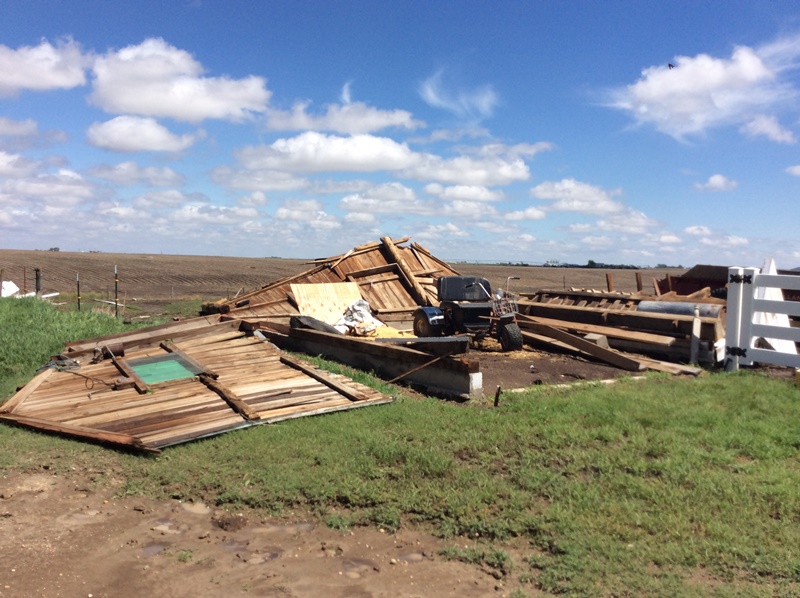
June 3rd-4th: Days with Tornadoes, Severe Thunderstorms & Intense Rains
In early June, a stationary frontal boundary resided near the Nebraska and Kansas border and moved very little for several days. The frontal boundary was the focus for thunderstorms, and severe storms developed during the evening hours on June 3rd and June 4th. The thunderstorms produced hail to the size of hen eggs (2 inches in diameter), strong wind gusts of 50 mph, and three tornadoes which touched down in the Tipton, KS area. Two of the tornadoes were rated EF1 and one tornado was rated EF0. Several rounds of heavy rainfall associated with the thunderstorms resulted in some hefty three day rainfall totals across the area with rainfall amounts averaging 3 to 6 inches, especially for locations south and east of Kearney and Grand Island, NE. From June 3rd through the 5th, a Nebraska rainfall observer locatd 5 miles northeast of Doniphan received 5.90 inches of rainfall, the Hastings National Weather Service office tallied 5.65 inches, Hebron reported 3.98 inches, and Grand Island received 2.75 inches of rain. The heavy rainfall caused areas of lowland flooding and washed out several county roads.
 |
 |
 |
| Tornado in the Tipton area photo by Nick Biermann |
Tornado Damage west of Tipton, KS photo by NWS staff |
Flooding south of McCool Junction, NE photo by NWS staff |
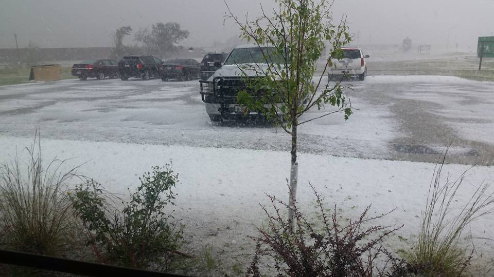
Hail covers the ground in Cambridge, NE September 9th. Photo by Cassie Jo
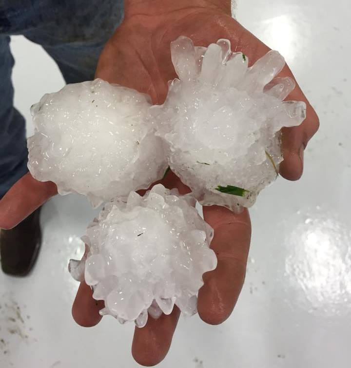
September 9-10th: Hailstorms
Both September 9th and 10th featured significant hail storms in terms of quantity of hail and in size. On September 9th, an unstable atmosphere combined with cold air aloft brought favorable conditions for severe thunderstorms. The storms produced a couple of swaths of hail, one from Arcadia to Grand Island to Shickley, and another from Eddyville to Miller to Kearney. Hail storms were more isolated in the Elwood and Cambridge areas. The storms produced copius amounts of hail, and hail covered the ground or piled up in Cambridge, Phillips and Kearney, Nebraska. Very large hail the size of golf balls were reported in Cambridge, Arcadia, Riverdale, Kearney, Loup City Dannebrog, and just north of Elyria. The following day (September 10th), saw a repeat of severe thunderstorms as an upper level disturbance and cold frontal boundary moved through. Hail the size of baseballs (or slightly larger) fell near Chester, Byron and Holbrook, NE while hail of ping pong ball size to golf ball size fell in the Carleton and Deshler areas in Nebraska, and in the Prairie View and Burr Oak areas in Kansas. The combination of the large hail combined with damaging thunderstorm wind gusts of 65 to 80 mph caused damage to vehickles, homes and crops.
 |
 |
 |
| Hail in the Kearney area 9/9/15 (photo by Richard Thomas) |
Thunderstorm near Chester, NE 9/10/15 (photo by Sarah Drake) |
Hail near Byron, NE 9/10/15 (photo by Corey Heitmann) |
October 11th : Record High Temperatures for the Day and Month
Temperatures on October 11th were hot! Grand Island topped out at 97 degrees for the day which was 30 degrees warmer than the normal high of 67 degrees. The 97 degree temperature set a new high temperature record, breaking the previous record of 93 degrees which was set in 1928. In addition, the 97 degree temperature was the warmest temperature ever recorded in October, breaking the previous record of 96 degrees which was set on October 5th, 1947.
Hastings also shattered its high temperature record on October 11th, reaching 97 degrees in the afternoon. The previous record was 89 degrees set in 1940 and in 1975. For the month of October, this 97 degree temperature tied the previous monthly record of 97 degrees which was set on October 5th, 1947.

'Moon Halo' November 21st. Photo by Bart Bennetzen via social media
November: A Month of Noteworthy Weather
The month of November featured several noteworthy weather events from record setting temperatures and precipitation, to the timing of winter storms arriving for Veteran's Day and Thanksgiving. Here's a look back at November 2015...
 |
 |
 |
| Nebraska Dept. of Roads webcam in Lexington on Veteran's Day, November 11th | Tornado damage on November 16th. (photo by NWS staff) |
Snow in Osceola on Thanksgivng Day. (photo by NWS Staff) |

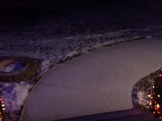
Snow Christmas Eve at the NWS office before sunrise. Photo by NWS Staff
December 24th-25th: Christmas Wintry Weather
Mother Nature came through again for the Christmas holiday, and both Christmas Eve and Christmas Day had their fair share of winter weather. Snow developed during the pre dawn hours on Christmas Eve and spread east overnight and in the morning. Snowfall amounts varied by location but a fairly widespread swath of one to three and a half inches were common across much of south central Nebraska and portions of north central Kansas. The timing of the snow on Christmas Eve gave the area a white Christmas for 2015 which is not very common (there is only a 25 to 40 percent chance for a white Christmas based on climatology). At Grand Island, the last time a white Christmas occurred was three years ago in 2012. There have only been eight white Christmas Days there in the last 30 years.
Christmas Day was crazy weatherwise with a full gamut of winter precipitation falling primarily across south central Nebraska. Sleet was intermittent during the day on Christmas, however by evening and into the overnight hours the brunt of the winter arrived and many locations experienced periods of sleet, graupel (snow pellets), freezing drizzle and freezing rain, as well as snow. The mixed wintry precpitation was accompanied by several hours of thunder, which is a rarity in December. Accumulations of snow, sleet and ice created slick outdoor surfaces and hazardous driving conditions. Winter Weather Advisories were in effect Christmas Day evening through mid-day on Saturday the 26th for much of south central Nebraska. When all was said and done, snow and sleet accumulations totaled 4.5 inches in Ord, 3.5 inches in Loup City, 3 inches in Greeley, and 1.1 inches at the Hastings National Weather Service.
|
| Christmas Day Snow Pellets Twitter Video from @NTVsSteveWhite |
 |
 |
| Christmas Eve Snow in Deweese, NE photo by Brenda Hansen |
Christmas Day Snow Pellets photo by NWS Employee |

