|
Event Summary:
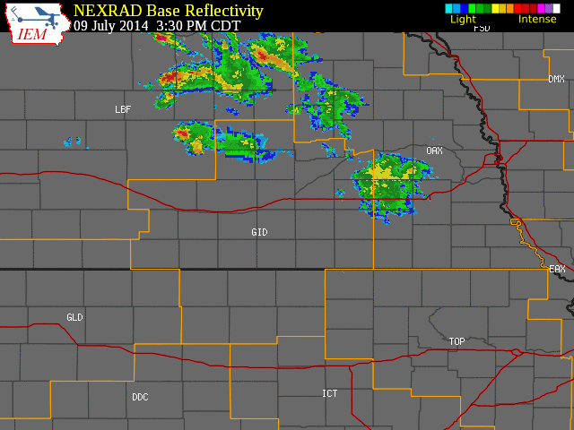
Starting during the late afternoon hours of Wednesday, July 9, 2014, and lasting into the early morning hours of Thursday the 10th, primarily the western half of the NWS Hastings coverage area (mainly west of the Highway 281 corridor) was raked with numerous severe thunderstorms that generally tracked from northwest-to-southeast. The first severe storms entered the local area into Valley County around 5 PM, and the final severe storm of the event affected mainly southern Gosper County around 2 AM. As a result, despite some "lull in the action" mainly late in the evening, this was a fairly long-duration event with severe storms affecting the local area over a span of nearly nine hours.
Although one Tornado Warning was issued for the Gibbon area around 7 PM based on radar-indicated rotation, there have been no verified observed/confirmed reports of a tornado as of July 10th. However, many of these storms produced considerable damage (primarily to crops but also to some structures) due to a nasty combination of hail and strong winds. Although many of the most significant reports of large hail and damaging winds are summarized in the bulleted section below, one can generally say that several storms contained copious amounts of mainly small hail up to quarter size, along with isolated larger hail up to around golf ball size, accompanied by straight-line winds of 50-70 MPH. An unofficial home weather station two miles northeast of Norman in Kearney County reported a gust as high as 85 MPH. Needless to say, these severe storms resulted in several generally northwest-to-southeast swaths of significant crop damage, some of which extended for dozens of miles.
As for heavy rainfall, although no widespread, significant flooding was reported or detected during this event, there were several instances of mainly short-term, minor flooding as a good chunk of the NWS Hastings coverage area received 1-2" of rain in a fairly short time, along with limited coverage of amounts in excess of 2". Per NWS cooperative observers and NeRAIN observers, a few of the highest storm-total rainfall amounts included 3.34" four miles southwest of Blue Hill and 2.70" four miles north of Gibbon.
In forecast hindsight, even though there were expectations for at least a few severe storms to develop during the late afternoon and evening of the 9th, this event ended up being more widespread/longer-lasting than originally anticipated. Although atmospheric instability was not unusually high for this time of year, deep-layer wind shear was fairly impressive by July standards at 40-50+ knots, which allowed some storms to become supercells and stay severe for a longer time (the mid-summer months usually have weaker wind shear compared to the peak severe weather months of April-June).
Several severe weather "highlights" from the event (additional reports will be added as they are received):
(PLEASE NOTE: Storm reports in the bullets and map link below do not represent ALL severe weather that occurred, only those reports received/processed by NWS Hastings. All storm reports are considered preliminary and subject to change pending final review and publication in NCDC StormData.
- Significant damage occurred in and near the communities of Gibbon and Ravenna. In and near Gibbon, a home lost part of its roof and a wrought-iron archway at the Gibbon Riverside cemetery was bent over. In Ravenna, several homes especially on the north side of town suffered broken windows and vinyl siding damage. Windows were also broken at the local library and a bank building.
- Golf ball size (1.75") hail was reported at the following locations: 6 NW Loup City, Ravenna, Gibbon, 4 SSW Shelton, 4 W Cowles, and 6 N Ord.
- Ping pong ball size (1.5") hail was reported at the following locations: Gothenburg, Arcadia and North Loup.
- Half dollar size (1.25") hail was reported 6 ESE Lexington.
- Quarter size (1.00") hail was reported at the following locations: 2 E Lexington, Heartwell, 1 W Kenesaw, Litchfield, Boelus and 5 NNE Arapahoe.
- Measured 85 MPH wind gust by a mesonet site 2 NE Norman.
- Estimated 70 MPH wind gust reported 1 SW Lexington and 4 W Cowles.
- Measured 68 MPH wind gust 3 S Gibbon.
- Esimated 60 MPH wind gust reported 4 NW Holstein, 1 SW Guide Rock, Gothenburg, 5 N Lexington and 4 SSE Kenesaw.
- Extensive crop damage reported in the Ravenna, Gibbon, Heartwell and North Loup areas.
- Tree damage reported 3 to 7 E of Kearney, 3 W Roseland and in Randall, KS.
- Grain bin damage 6 E Kearney.
- Semis were blown over 2 W Gibbon on Highway 30 and near the Minden interchange of Interstate 80.
 |
Preliminary storm reports
(click image for interactive map) |
 |
Satellite imagery showing the crop
damage caused by the wind & hail. |
Here are a few photos from across the area:
 |
 |
 |
 |
Crop damage between Kenesaw and Holstein. Photo courtesy of
Roger Peters. |
Crop damage between Kenesaw and Holstein.
Photo courtesy of
Roger Peters. |
Crop damage near Gibbon.
Photo courtesy of
Emily Hahn. |
Crop damage south of Loup City.
Photo courtesy of
Diane Axmann. |
 |
 |
 |
In Ravenna.
Photo courtesy of
Kris Oberg-Simon. |
In Ravenna.
Photo courtesy of
Mandy Grant. |
In Ravenna.
Photo courtesy of
Mandy Grant. |
 |
 |
In Ravenna.
Photo courtesy of
Manolito Solis. |
Home damage in Ravenna.
Photo courtesy of
Kaylene Finke. |
 |
 |
 |
In Loup City.
Photo courtesy of Jared Jaixen. |
Hail drifts along Highway 6 near Adams/Kearney line. Photo courtesy
of Angela Oder. |
In Heartwell.
Photo courtesy of Brynn Gustafson. |
 |
 |
 |
 |
East of Norman near Highway 74.
Photo courtesy of
Valerie Werth. |
In Ord.
Photo courtesy
of Becca Nance. |
Near the Minden I-80 interchange.
Photo courtesy
of Colby Lange. |
Near the Minden
I-80 interchange.
Photo courtesy of
Colby Lange. |
|