National Weather Service United States Department of Commerce

Severe Thunderstorms in the East Sunday; Excessive Heat Lingers in the Southern U.S. and Returning to California

Scattered damaging winds from severe thunderstorms will be possible across parts of the Northeast and Mid-Atlantic States Sunday. Excessive heat will continue over the southern U.S. Sunday before another round of heat arrives Monday through the central and southern U.S. spreading into the East by Independence Day. California will see excessive heat starting Tuesday. Read More >

Changed addresses or phone numbers recently? Email tony.merriman@noaa.gov with your updated information!


2024 SKYWARN Storm Spotter Training

SKYWARN is a program that trains volunteers to help keep their local communities safe by providing timely and accurate reports of monsoon season weather to the National Weather Service. In the program you’ll learn about:

  • The basics of thunderstorm development
  • The fundamentals of storm structure
  • Identifying potential severe weather features
  • How to report severe weather
  • Basic severe weather safety

In-person training sessions are listed below. They are free and there is no need to RSVP!

Date Start Time Location Building Address Google Map Link
Monday, May 6 6:00pm Arizona Time Embry-Riddle Aeronautical University
Davis Learning Center Auditorium
3700 Willow Creek Rd.
Prescott, AZ 86301
Directions
Wednesday, May 8 6:00pm Arizona Time Coconino County Public Health 2625 N King St.
Flagstaff, AZ 86004
Directions
Tuesday, May 14 5:00pm Arizona Time Camp Verde Community Library 130 Black Bridge Rd.
Camp Verde, AZ 86322
Directions
Tuesday, May 21 5:30pm Arizona Time Payson Public Library 328 N. McLane Rd.
Payson, AZ 85541
Directions
Tuesday, June 4 6:00pm Arizona Time Show Low Police Department 411 E. Deuce of Clubs
Show Low, AZ 85901
Directions
Two Options to Submit Reports: Phone or Online (click image below)

If submitting a report by phone (888-745-1637), it is very important to tell us WHEN and WHERE the significant weather event occurred. For geographic reference, an intersection and town are very useful so we can pinpoint the report. If it's a second or third hand report, please give us the source of the original report, along with all the applicable information about what was reported.

Hail Size Reporting Reference

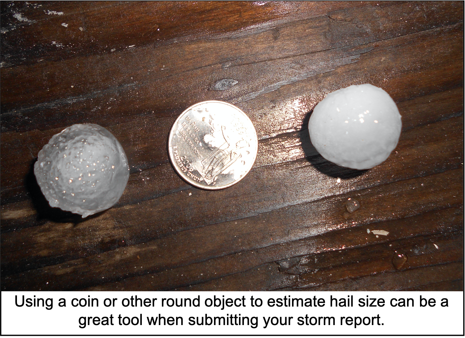
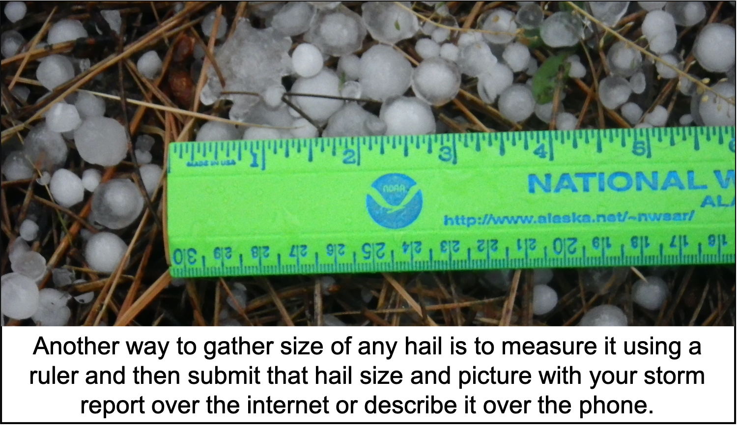
Please report the size of the largest hailstones as they cause the most damage. Also, please do not use the term "marble size" or "ice cube" since these items come in many different sizes.

  • 0.25 inch - Pea
  • 0.50 inch - Dime
  • 0.75 inch - Penny
  • 0.88 inch - Nickel
  • 1.00 inch - Quarter (Severe)
  • 1.25 inch - Half Dollar (Severe)
  • 1.50 inch - Ping-Pong (Severe)
  • 1.75 inch - Golf Ball (Severe)
  • 2.00 inch - Hen Egg (Severe)
  • 2.50 inch - Tennis Ball (Severe)
  • 2.75 inch - Baseball (Severe)
  • 3.00 inch - Tea Cup (Severe)
  • 4.00 inch - Grapefruit (Severe)
  • 4.50 inch - Softball (Severe)

Wind Speed Reporting Reference

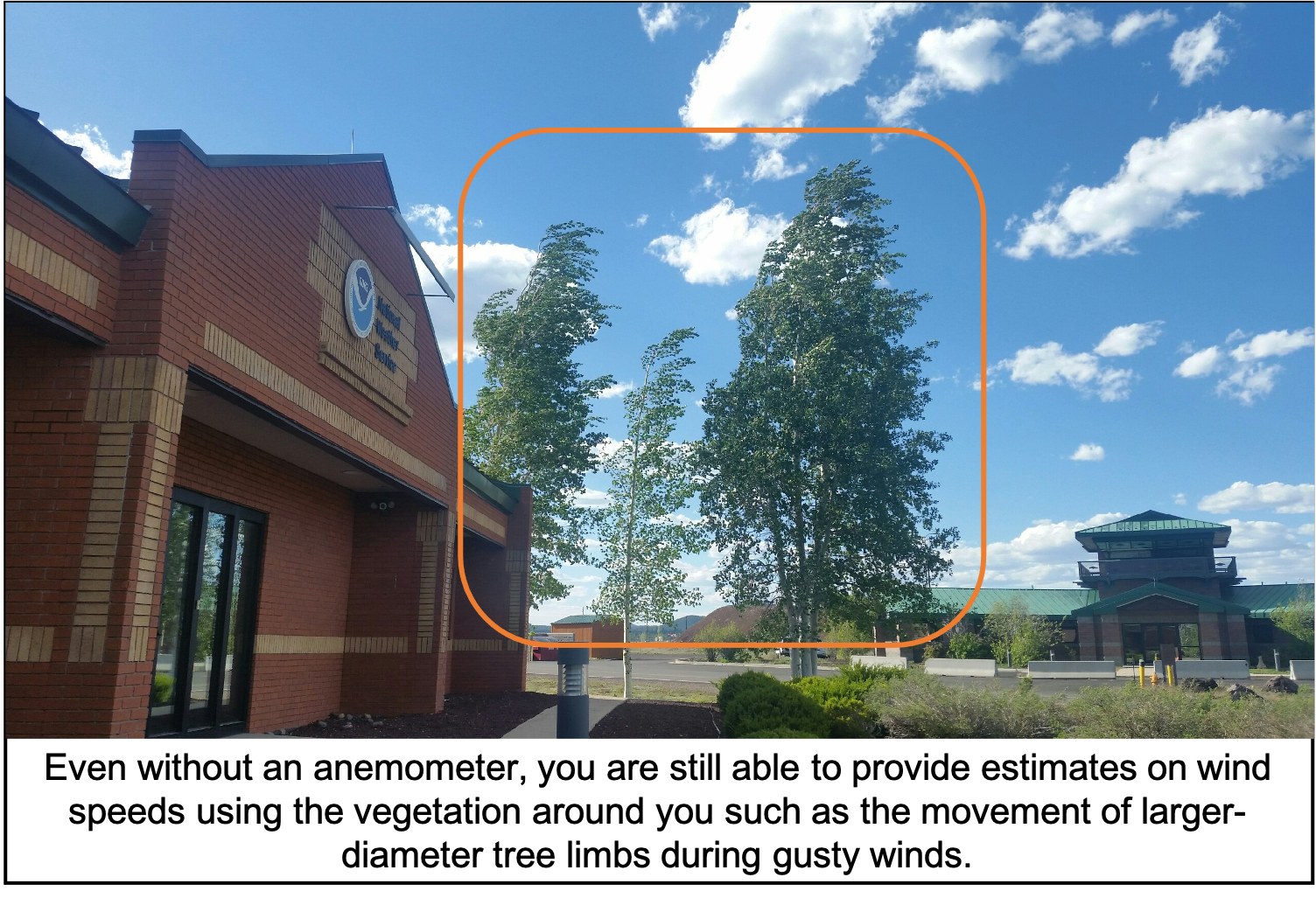
Please report both the estimated wind speed based on the vegetation (see descriptions below) and also any damage or impacts to life and property caused by strong to severe winds.

  • 25-31 mph: Large branches in motion; whistling heard in power lines.

  • 32-38 mph: Whole trees in motion; inconvenience felt walking into the wind.

  • 39-57 mph: Twigs break off trees; wind generally impedes progress; garbage cans blow over.

  • 58-72 mph (Severe): Shallow-rooted trees blown over; trampolines can flip over; sheds and pole barns can sustain damage; downed power lines are possible.

  • 73-112 mph: Surface of roofs peeled away; windows broken; mobile homes pushed or overturned; moving cars pushed off roads.
Remember, you are a storm spotter, not a storm chaser! Only submit a storm report if you are in a safe location and situation to do so, never put yourself in harms way to submit a storm report.
  • Dust Devil versus Funnel Cloud versus Tornado
    • Dust Devil - Generally form on a hot and clear day, typically in the afternoon to early evening time period. Dust Devils are in contact with the ground, but never a cloud and can last on the scale of seconds to tens of minutes.

    • Funnel Cloud - Rotating column of air that extends from the base of cloud, but does not make contact with the ground. These are commonly spotted during the northern Arizona monsoon season or during the early fall season when strong cold fronts can push across the Southwest.

    • Tornado - Rotating column of air that extends from a cloud to the ground. Tornadoes have been known to form in both the monsoon season and be associated with strong cold fronts that cross over the Southwest during the early to late fall time period.
  • Dust Storm - While more rare in northern Arizona compared to the lower elevation deserts of central and southern Arizona, these events are most likely in the Chinle Valley, along Hwy 160 across Navajo Nation and within the Little Colorado River valley. If you encounter a dust storm, pull aside on the roadway and turn off your lights. When you report a dust storm, include an estimate of how much the visibility has been reduced to at your specific location (1 mile visibility or less than 1 mile or less than 1/4 mile etc.).

  • Flash Flood - Never enter flood waters to try and take a measurement for a spotter report. Instead, estimate the water depth based on visible landmarks or prior background of channel depth when providing your report.

  • Severe Hail - Hail that is at least the size of a quarter or larger. We always want to receive reports of all sizes of hail though! Hail size can either be measured by a ruler or estimated based off a fixed round object. See the Submit Report tab for a list of coins and other items to base your hail size estimation off.

  • Snowfall versus Snow Depth - Snowfall refers to the amount of new snowfall over a given time period while snow depth refers to the amount of snowfall that has accumulated on the ground.
    • Snowfall measurements (measured to nearest tenth of an inch) - Place a flat board away from any structure or large vegetation in an area secluded from the wind. Take snowfall measurements using a ruler all the way down to the bottom of the board. Record the observation and time period over which the the snowfall occurred. Clear off the board and be ready for your next snowfall measurement.

    • Snow depth measurements (measured to nearest inch) - Take a ruler out into an area away from snow drifts and that generally represents the surrounding snow pack. Stick the ruler all the way down till you reach the ground and record the snow depth measurement. A few different measurements might be needed to then take an average snow depth.

  • Strong to Severe Winds - We understand it can be difficult to estimate wind speeds without an anemometer. If you can, provide the estimated speed based off a tree. See the Submit Report tab for specific reference points.