
Super Typhoon Sinlaku will bring destructive winds, widespread heavy rain/flooding, and thunderstorms to the Marianas Islands into Wednesday. Tropical Storm conditions are likely over Guam. Severe thunderstorms and heavy rain are likely across the Upper Mississippi Valley and Great Lakes region with potential for large to very large hail, damaging wind, and tornadoes through Tuesday. Read More >


Media is free to use the NWS Flagstaff Event Summary information. Please acknowledge the NWS as the source of any information accessed from the site unless otherwise noted.
A low pressure system over Texas pushed west and interacted with deep monsoonal moisture already over the Southwest from July 22-25, 2021. This led to a few days of widespread thunderstorms with very heavy rainfall rates. By the weekend, soils were saturated across the area enhancing the already high flash flood threat. Some rivers in central and northern Arizona crested near known record values. Numerous roads were washed out or impassable due to flooding. The Millet Swale Levee experienced a slow break and resulted in minor flooding in Taylor, Arizona. Structural flooding was reported near Show Low, in St. Johns and the village of Moenkopi. This was one of the most widespread impactful flooding events during a monsoon season in recent memory.
 Radar loop showing continuous bands of strong thunderstorms.
 Radar loop showing more continuous bands of strong thunderstorms.
 Radar estimated one hourly precipitation showing continuous bands of moderate to heavy rainfall.
 Radar estimated one hourly precipitation showing more continuous bands of moderate to heavy rainfall.
Flooding on a road in Cowsprings, Arizona on the Navajo Nation. Similar scenes were very common across the Navajo Nation and northern Arizona for any unpaved roads. Image courtesy of Sheena Lee from Facebook

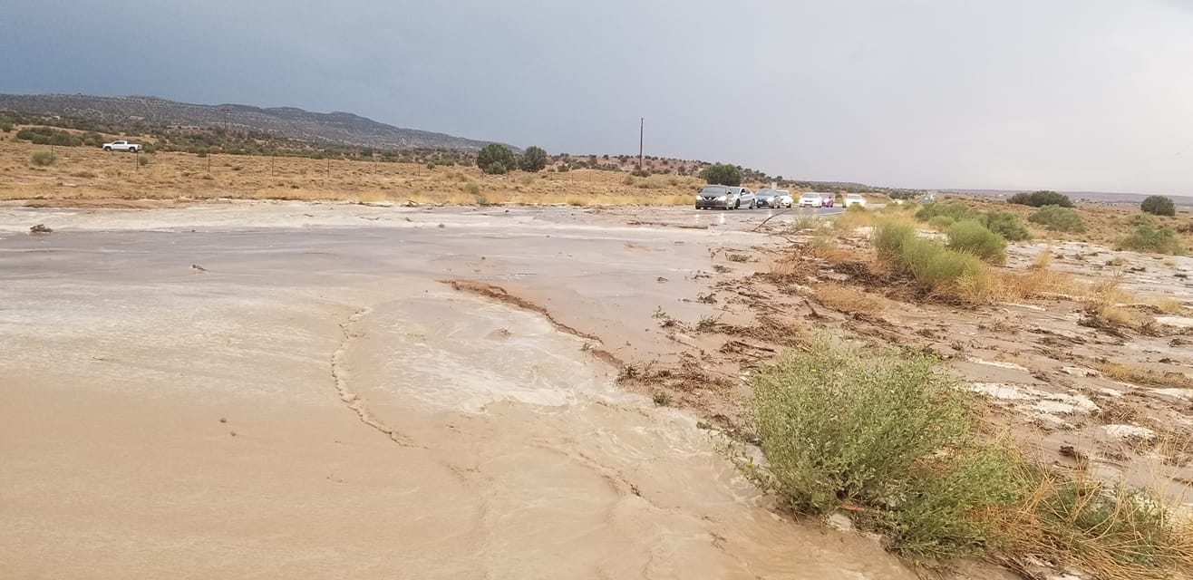
Flooding occurred in Moenkopi Wash and into the village. The photo was taken around 11 AM MST on Sunday, July 25, 2021 overlooking the village by Travis Honanie.

Little Colorado River in Joseph City in the morning of July 24, 2021. Image courtesy of Vicki Miller Sutton from Facebook

Rio De Flag crossing on Herold Ranch Road on Sunday, July 25th, 2021. Image courtesy of Betsey McKellar from Facebook

Water levels on the Agua Fria River experienced multiple peak flows on July 23rd and 24th, 2021 due to very heavy rainfall upstream near Dewey-Humboldt and Prescott, Arizona. Shown is a hydrograph for the Agua Fria River at Humboldt with river stage (in feet) on the left and river flow (cubic feet per second) on the right.
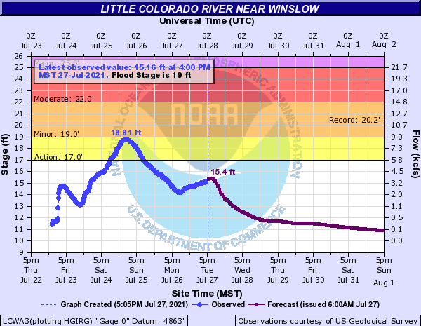
Water levels on the Little Colorado River near Winslow began to rise around 5 AM MST on Saturday July 24 and peaked just under Minor Flood Stage about twenty four hours later. Flood waters dropped below Action stage (when roads can become washed out) by Sunday evening. Shown is a hydrograph for the LCR at Winslow with river stage (in feet) on the left and river flow (cubic feet per second) on the right.

Water levels on Oak Creek experienced multiple peak flows on July 23rd, 24th and 25th, 2021 due to very heavy rainfall north of Sedona. Minor flooding occurred twice. Shown is a hydrograph for Oak Creek at Cornville with river stage (in feet) on the left and river flow (cubic feet per second) on the right.
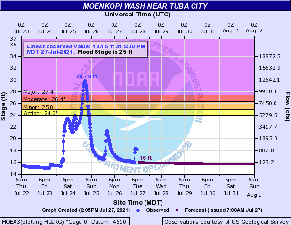
Water levels in Moenkopi Wash rose nearly thirteen feet to peak at 29.8' (from a base flow just under 16') as very heavy and persistent rainfall on Black Mesa flowed downstream. Homes and low water crossings in the village of Moenkopi and some near Tuba City were inundated from the flooding. Shown is a hydrograph for Moenkopi Wash just south of Tuba City with river stage (in feet) on the left and river flow (cubic feet per second) on the right.

Twenty-four hourly rainfall across northern Arizona from July 21-25, 2021. The most widespread heaviest precipitation occurred on July 23 and 24, 2021.

Month of July 2021 percent of normal precipitation for northern Arizona. The very high values, especially over the Navajo Nation, mostly fell between July 22-25, 2021.
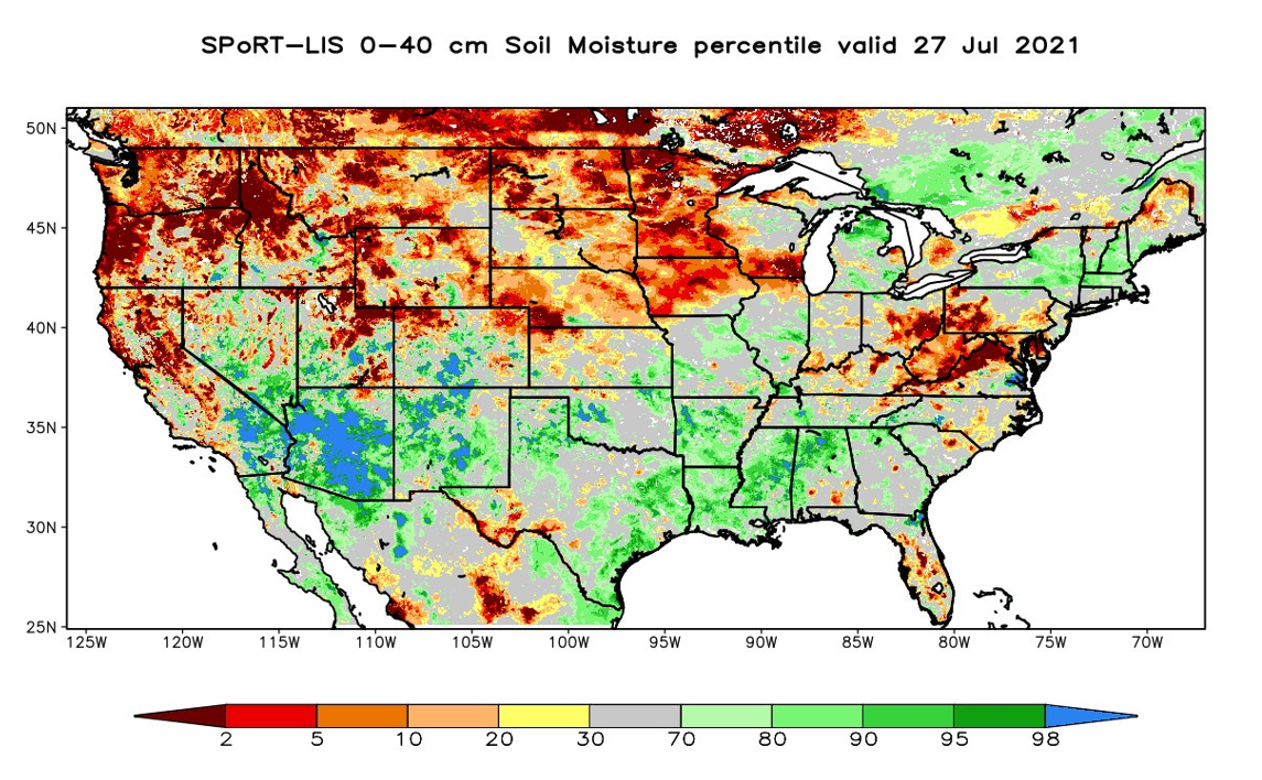
The wet month of July (see Percent of Normal map) left soils in central and northern Arizona very saturated. The saturated soils (upward of the 98th percentile in much of the region) created significant concerns for flash flooding anywhere even after the event ended.

The widespread heavy rainfall over northern Arizona helped to decrease the severity of drought conditions over the state. The drought monitor for Arizona issued on July 27, 2021 is shown left, while greater coverage of Extreme to Exceptional drought conditions can be seen right on the map issued July 20, 2021.
Deep monsoon moisture had been in place across northern Arizona for several days leading to afternoon thunderstorm activity. An easterly wave over Texas pushed west and interacted with the deep monsoonal moisture providing an unusual amount of dynamics for this time of year. This led to a few days of widespread thunderstorms with very heavy rainfall rates. Convection persisted into the overnight hours on most days leading to an almost around the clock flood threat for much of northern Arizona. By the weekend, soils were saturated across the area enhancing the already high flash flood threat.
 A very anomalous easterly wave undercut high pressure over the northern CONUS region to bring a dynamic setup for three days over northern Arizona. The mid-level easterly flow created a west-southwestward storm motion. Shown are GEFS mean 500 mb heights from 5 AM July 21 - 11 PM July 25, 2021 with wind vectors highlighting that easterly flow.
 NAM12 Analysis precipitable water from 5 AM July 21 - 11 PM July 25, 2021 is shown for Arizona. Precipitable water values in this period were much higher than what is typical during any normal monsoon day, especially in northern Arizona. This created the very moist atmosphere needed for three days of daytime and nighttime riverine, areal and flash flooding across the state.
For more information on impacts and general inquiries about this event, contact by sending an email to or by calling .

