
SKYWARN is a program that trains volunteers to help keep their local communities safe by providing timely and accurate reports of monsoon season weather to the National Weather Service Read More >


Media is free to use the NWS Flagstaff Event Summary information. Please acknowledge the NWS as the source of any information accessed from the site unless otherwise noted.
A major winter storm impacted northern Arizona over the Thanksgiving holiday, bringing very heavy wet snow, and causing significant travel disruptions, road closures and power outages. The system initially had high snow levels above 8,000 feet, with rain falling in most areas. Colder air along and behind a very strong cold front brought widespread moderate to heavy snowfall (3-4"/hr snowfall rates) above 5,000 feet beginning early Friday morning and continuing into early Saturday. The combination of heavy, wet snow and strong winds caused multiple power outages, most notably in Tusayan and the Grand Canyon. Over 30 inches of snow was reported near Hwy 180 at Hart Prairie (at the base of the San Francisco Peaks). Travel conditions improved over the weekend as roads reopened and temperatures gradually warmed.

Radar images show the main frontal bands of rain and snow began to impact central and northern Arizona during the night of the 28th into the morning of the 29th.

Radar images during the daytime on Friday the 29th showing the shift from widespread bands of frontal precipitation to snow showers.
×

GOES-17 Visible Satellite Imagery. Image was captured around noon MST on Saturday, November 30, 2019 and shows the expansive snowpack across northern Arizona.

Observed Storm Total Snow from Thursday night to Saturday morning. Access all local storm reports throughout Arizona for this storm.
×

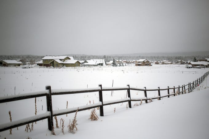
16-19 inches of snow fell across the Flagstaff area early Friday morning through early Saturday. Photo Credit: The Republic

Prescott saw several inches of snow leading to hazardous travel conditions. Photo Credit: The Republic

Heavy snowfall and low visibility on Interstate 40 between Kingman and Seligman Friday morning. Photo Credit: ADOT

Whiteout conditions were seen Friday on SR-264 near Window Rock. Photo Credit: ADOT

Gusty winds accompanied this storm leading to wind blown snow sticking on the trees around the higher elevations of northern Arizona. Photo Credit: The Republic
Flagstaff residents woke up to a winter wonderland on Friday November 29th, 2019. Snow showers continued through the day leading to several inches of additional accumulation. Photo Credit: The Republic

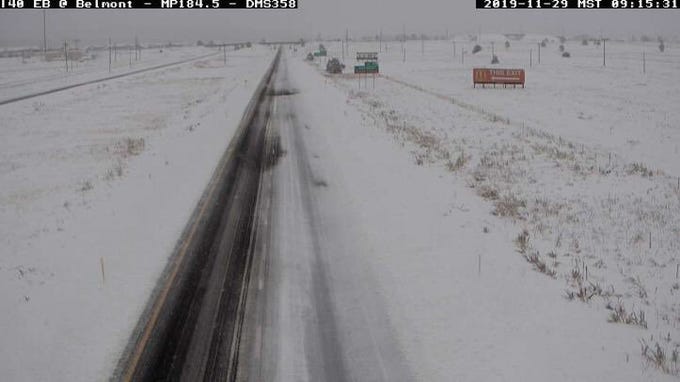
Heavy snow falling early Friday morning on Milton Rd in Flagstaff. Photo Credit: ADOT

Snow covered Milton Rd in Flagstaff mid-morning Friday. Photo Credit: ADOT
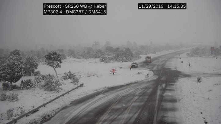
SR-260 was closed between Camp Verde and Heber during the storm due to very hazardous travel conditions. Photo Credit: ADOT

Snow-packed roadways were seen across much of the higher terrain of northern Arizona. Here is a look at conditions on SR-64 in Williams on Friday afternoon

Heavy snow fell across the south rim of the Grand Canyon and brought up to two feet in some areas. Photo Credt: GCNP
Interstate 40 was closed through a large portion of northern Arizona during the storm. Photo Credit: ADOT
Three primary ingredients are needed for heavy snow: cold air, moisture, and lift. A plume of subtropical moisture moved northeastward into Arizona from the night of November 27th, 2019 into the afternoon of November 28th, 2019. This warm and very moist airmass led to widespread precipitation across northern Arizona. The source region of the moisture initially resulted in high snow levels above 7,500 feet through Thanksgiving night. Snow levels dropped rapidly early Friday morning along and behind a very strong cold front and upper level low pressure system, which generally moved to the east. This system provided additional strong lift and moisture into the region, resulting in widespread moderate to heavy snowfall through much of Friday. The system exited the region early Saturday, with temperatures struggling to reach freezing Saturday afternoon along the Mogollon Rim.

Progression of the air masses that created the heavy rain and snowfall from Thursday during the day into Friday night.
For more information on impacts and general inquiries about this event, please reference the contacts below:

