Dangerous heat will expand from the Gulf Coast into the Southern Plains and Desert Southwest through week's end. Additional extreme heat impacting the Pacific Northwest will shift to the northern Plains by the weekend. Tropical Storm Bertha is expected to continue to impact portions of the northern Gulf Coast from the western Florida Panhandle to southeastern Louisiana through tonight. Read More >
Severe Thunderstorms and Tornadoes
![]()
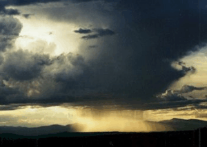 |
| Photo: NWS Flagstaff |
A thunderstorm is a local storm that produces lightning and thunder. It can consist of a single cumulonimbus cloud, a cluster of clouds, or a line of clouds. Thunderstorms form when moist, unstable air near the surface is lifted. This lifting can be caused by thermals generated from a strongly heated surface, the forcing of air upward along a frontal surface or terrain surfaces, or by the upward motion produced by winds converging near the surface. Thunderstorms are generally transient phenomena that last anywhere from 10 minutes to several hours. Thunderstorms are often accompanied by showery rain and gusty winds, and may also bring hail or snow. Thunderstorms occur most frequently during summer, but they are not unknown in the winter when thunder can sometimes be heard during intense snowstorms.
Thunderstorms are categorized as ordinary and severe. Severe thunderstorms generally last longer than ordinary thunderstorms and can produce very strong winds, flooding, hail, and/or tornadoes. Ordinary thunderstorms are generally short lived and generally do not produce very strong winds or large hail.
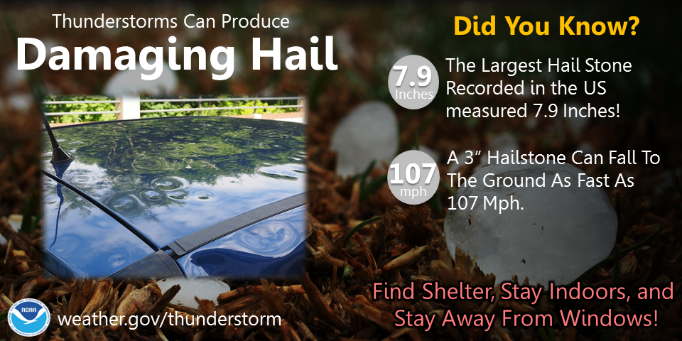
Many thunderstorms typically undergo a three-stage life cycle. In the cumulus stage (a), warm, moist air rises in a buoyant plume or in a series of convective updrafts. When the air becomes saturated, a convective cloud begins to grow. As the warm air plume continues to rise, more water vapor condenses, releasing the latent heat of vaporization. This heat enhances the convection and makes the buoyant plume grow faster. The cloud edges during this stage are sharp and distinct, indicating that the cloud is composed primarily of water droplets. The convective cloud continues to grow upward, eventually growing above the freezing level where supercooled water droplets and ice crystals coexist.
The mature stage (b) of a thunderstorm is characterized by the presence of both updrafts and downdrafts within the cloud. The downdrafts are initiated by the downward drag of falling precipitation. The downdraft is strengthened by evaporative cooling, as the rain falling with the downdraft enters drier air below the cloud base and evaporates. This cold descending air in the downdraft will often reach the ground before the precipitation. Cloud to ground lightning usually begins when the precipitation first falls from the cloud base. During this phase of the life cycle, the top of the cloud will start to flatten out, forming an anvil shape.
The decaying stage (c) of a thunderstorm is characterized by downdrafts throughout the entire cloud. Decay often begins when the supercooled cloud droplets freeze and the cloud becomes glaciated, which means that it contains ice crystals. Glaciation typically first appears in the anvil, which becomes more pronounced in this stage. The glaciated cloud appears filmy, or diffuse, with indistinct cloud edges. The cloud begins to collapse because no additional latent heat is released after the cloud droplets freeze, and because the shadow of the cloud and rain cooled downdrafts reduce the temperature below the cloud. The decay of a thunderstorm can also be initiated when the precipitation within the storm becomes too heavy for the updrafts to support, when the source of moisture is cut off, or when lifting ceases.
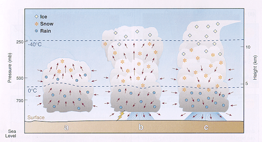 |
| The three stages of the life cycle of air mass thunderstorms: (a) cumulus stage, (b) mature stage, and (c) decaying stage. Arrows indicate wind directions. (Adapted from Byers and Braham, 1949) |
The structure and life cycle of severe thunderstorms are fundamentally different from general thunderstorms. As mentione d above, general thunderstorms are composed of updrafts which become downdrafts as the precipitation begins to fall and the updraft can no longer support the weight of the precipitation. The updrafts in severe thunderstorms, in contrast, tend to be tilted by strong vertical wind shear. Wind shear simply means that the wind changes direction or increases significantly in speed with height. Since the updrafts tilt over the downdrafts, this allows heavy precipitation to fall out of the updrafts and into the downdrafts. The updrafts can thus continue without having to support heavy suspended precipitation.
Although rain, hail, lightning, and winds can be associated with any thunderstorm, severe thunderstorms tend to produce more precipitation, larger hail, more lightning, and stronger winds. Severe thunderstorms can occasionally spawn tornadoes and funnel clouds.
In Arizona, our most significant danger from severe thunderstorms is in the form of strong damaging winds. Strong, localized downdrafts, called downbursts, often occur along the leading edge of a severe thunderstorm and its associated rainfall. These cool, gusty winds result when downdrafts within the storm are strengthened by evaporative cooling as precipitation falls into the drier air below the cloud base and evaporates. When the downburst hits the ground, it fans out radially in all directions. Winds associated with downbursts can easily exceed 58 mph, which would categorize it as a severe thunderstorm, according to National Weather Service standards.
 |
| Photo: NOAA |
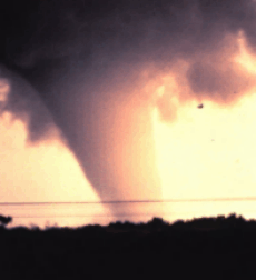
A tornado is a vortex of air rising into a cloud. As mentioned, in their early and mature stages, all thunderstorms are characterized by the updraft, which supply the storm with warm, humid air for continued growth. But, in some cases, the column of rising air can give rise to a rapidly spinning vortex, which can become a funnel cloud, or a tornado. Winds in most tornadoes blow at 100 mph or less, but in a few cases, the vortex can become a strong tornado with winds of up to 300 mph.
Often, a tornado forms along the edge of the updraft, next to the downdraft that is formed from falling precipitation and rain cooled air. As mentioned above, in severe thunderstorms the updraft and downdraft remain separate allowing for more optimal tornado generation. To keep the updraft and downdraft separate, wind shear is required. Strong tornadoes tend to form in environments where winds at all levels are not only strong, but also t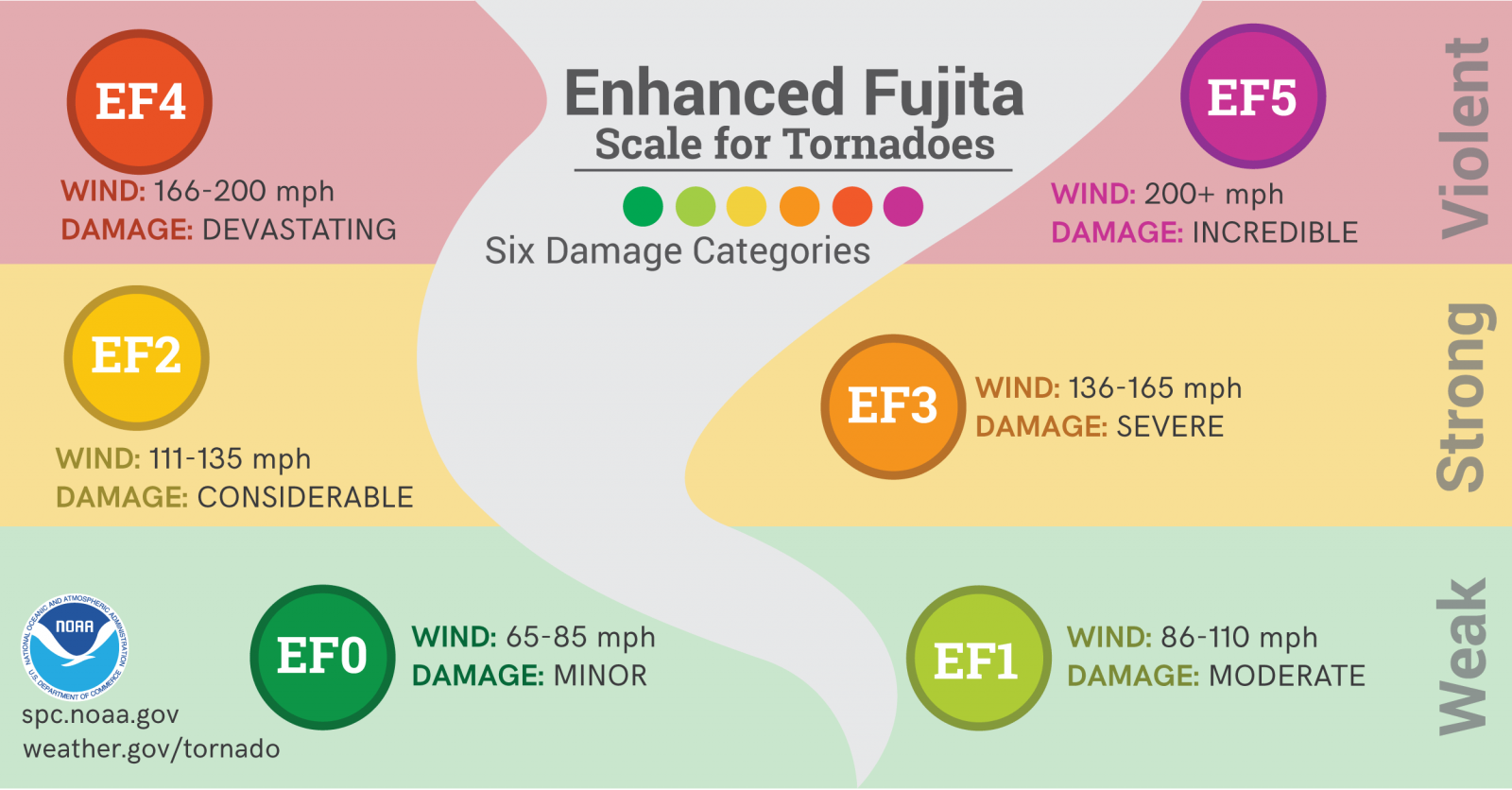 urn in height in a clockwise, or veering, direction. As the downdraft hits the ground, the air is forced to spread outward away from the downdraft. This air acquires spin, which under optimal conditions, can be acted on by the updraft and stretched into the cloud, developing into a funnel cloud. If this funnel cloud reaches the ground, it becomes a tornado. This is one mechanism through which tornadoes can form.
Tornadoes can form in other ways as well. One of the key questions that scientists are trying to answer about tornadoes is why updrafts in some thunderstorms become these twisting whirlwinds, while those in apparently similar thunderstorms do not. Many field studies have occurred which try to increase our knowledge of how tornadoes form.
While Arizona does not see tornadoes of the magnitude and frequency of the Midwest, there are typically a few tornadoes in Northern Arizona every summer. Most of the tornadoes in Northern Arizona are very weak producing winds less than 70 mph and lasting 5 minutes or less. An average of 4 tornadoes touch down in Arizona each year. Two tornadoes struck Yavapai County near Prescott in September 1999 which caused several thousands of dollars in damage to personal property.