
Thunderstorms and periods of heavy to excessive rainfall will continue over Florida through Thursday. Gusty winds and low humidity will promote elevated to critical fire weather conditions from central Georgia into north-central North Carolina Wednesday. A Kona Low is expected to bring strong winds, widespread heavy rainfall, and flooding concerns to the island chain through the weekend. Read More >


Media is free to use the NWS Flagstaff Event Summary information. Please acknowledge the NWS as the source of any information accessed from the site unless otherwise noted.
Thunderstorms built over the greater Flagstaff area on Tuesday, July 13, 2021 and produced heavy rainfall over the Museum Fire scar by mid-afternoon. Runoff and debris from the scar travelled downstream and resulted in flash flooding in much of northeastern Flagstaff late that afternoon. Roads were closed, homes were inundated and hazardous travel conditions were observed. Another active day setup on Wednesday, July 14 as anomalously high rain rates were again observed in the Upper and Lower Greenlaw neighborhoods in northeastern Flagstaff. Considerable flash flooding was captured on video with many inches of water clogging roads and inundating even more homes in local communities. Moderate rainfall was also observed on the 14th over the Museum Fire scar area, but most runoff came from the urban Flagstaff area that day.
 Flooding due to heavy rainfall over the Museum Fire scar - Radar loop from 11 AM - 5 PM July 13, 2021 showing very strong thunderstorms directly over the Museum Fire scar area immediately north of the city.
 Flooding mainly due to heavy rainfall in northeast Flagstaff - Radar loop from 11 AM - 5 PM July 14, 2021 showing a second day in a row of very strong thunderstorms directly over Flagstaff, AZ and the Museum Fire scar area immediately north of the city.
 Flooding due to heavy rainfall over the Museum Fire scar - High rain rates were observed on the Museum Fire scar around 2 PM MST on July 13, 2021. Between 1-2" of rain was estimated by radar from 2-3 PM MST. Shown are 1-hourly precipitation estimates from the KFSX WSR-88D radar from that day.
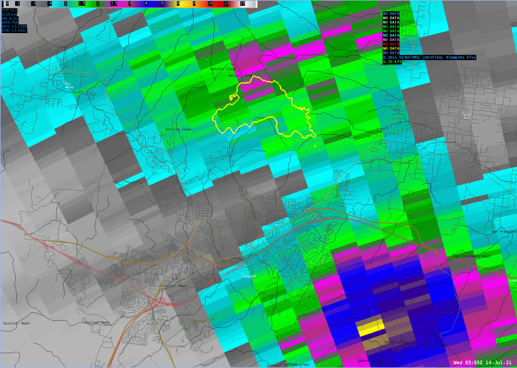
 Flooding mainly due to heavy rainfall in northeast Flagstaff - Another day of heavy rainfall were observed in northeastern Flagstaff around 2-3 PM MST on July 14, 2021.Shown are 1-hourly precipitation estimates from the KFSX WSR-88D radar from that day.
July 13 - Flash flooding was observed in the National Forest north of Flagstaff, AZ after heavy rainfall on the Museum Fire scar. Flood waters eventually flowed downstream and impacted parts of the Grand View, Mount Elden Estates and Sunnyside neighborhoods in town.
July 13 - Flash flooding was observed in the National Forest north of Flagstaff, AZ after heavy rainfall on the Museum Fire scar. Flood waters eventually flowed downstream and impacted parts of the Grand View, Mount Elden Estates and Sunnyside neighborhoods in town.
July 14 - Flash flooding within Flagstaff, Arizona after heavy rainfall over northeastern parts of the city and moderate rainfall on the Museum Fire scar.
July 14 - Flash flooding within Flagstaff, Arizona after heavy rainfall over northeastern parts of the city and moderate rainfall on the Museum Fire scar.
The spruce wash and culvert post flood. Taken at about 4 p.m., an hour after the first video. @azds #Flagstaff pic.twitter.com/mP8wi94iIw
— Adrian Skabelund (@AdrianSkabelund) July 14, 2021
Second day of flooding in east side neighborhoods of #flagstaff due to the Museum Fire burn scar.
— Robert Gooch (@ravenrider4k) July 14, 2021
Video is taken at the bottom of Paradise Road and Linda Vista Dr.@FOX10Phoenix @azfamily @abc15naz @ABC7 @12NEWSWEATHER pic.twitter.com/hvmKf1g714
Deep monsoonal moisture was entrenched over north-central Arizona by mid-July 2021. Diurnally-driven thunderstorms formed over the San Francisco Peaks area by late morning to Noon on July 13 and 14, 2021. The Museum Fire scar (formed in July 2019 after the fire was extinguished) had not yet had a moderate to high intensity rainfall over it, therefore July 13, 2021 was a "first flush" of debris from the scar. Nearly-stationary thunderstorms produced an estimated 1 - 2" of rainfall in 30 to 45 minutes across much of the scar. Flood waters flowed downstream within the Spruce Creek watershed and created flash flooding that was two to four feet deep. Debris was also carried downstream and embedded within the flood waters. Another active day occurred on July 14, 2021 as a continued moist atmosphere allowed for very high rainfall rates in area thunderstorms. Peak radar estimated rainfall rates were 4-8" per hour over the urban northeastern Flagstaff area by mid-afternoon. That extremely heavy rainfall over a short-period caused considerable sheet flooding on area roads and resulting damage. Observed rainfall totals on July 14 were 2.5 - 3.5".
 Flooding due to heavy rainfall over the Museum Fire scar - High rain rates were observed on the Museum Fire scar on July 13, 2021. Shown is the storm total estimated rainfall from around 5:40 AM to 6 PM MST from the KFSX WSR-88D radar.
 Flooding mainly due to heavy rainfall in northeast Flagstaff - Another day of heavy rainfall were observed in northeastern Flagstaff on July 14, 2021. Shown is the storm total estimated rainfall from around 8:30 AM to 9 PM MST from the KFSX WSR-88D radar.
For more information on impacts and general inquiries about this event, contact by sending an email to or by calling .
Media is free to use this event summary information. Please acknowledge the National Weather Service as the source of any information accessed from the site unless otherwise noted.

