
Dangerous and extreme heat will remain across portions of the Central U.S. this week, persisting across the Mid to Lower Mississippi Valleys, Gulf Coast, Southern Plains and portions of Texas. A heat wave over the Southwest will intensify late this week. Severe thunderstorms and flash flooding will spread from the Great Lakes/Ohio Valley to the Mid-Atlantic and Northeast the next few days. Read More >
What is La Niña?![]()
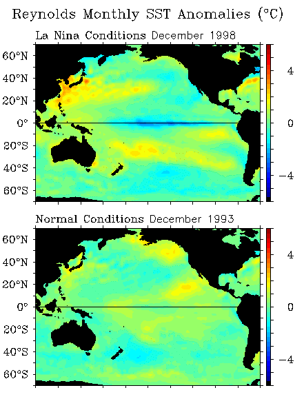
La Niña is defined as cooler than normal sea-surface temperatures (SSTs) in the tropical Pacific ocean that impact global weather patterns. This deviation from normal SSTs can have large scale impacts, not only on ocean processes, but also on the atmosphere. The graphic shown at the lower-left shows a normal SST pattern from December 1993, indicating no large scale deviations in the SST pattern.
The upper graphic shows the SST pattern from December 1998 which happened to be during our last La Niña event. It is easy to see the large broad area of blue, centered on the equator over the eastern Pacific Ocean. This area of blue denotes SSTs which are 2-5 degrees cooler than normal values at that time of year. This is the signal that scientists look for when diagnosing La Niña events. As can be seen, the size of this cool pool of ocean water is quite larg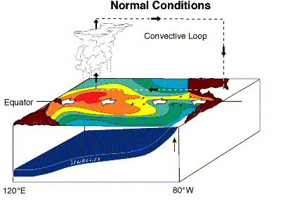 e, occasionally as long as the entire United States!
In normal, non-La Niña conditions (shown in the diagram to the left), the trade winds blow toward the west across the tropical Pacific Ocean. These winds pile up warm surface water in the west Pacific, so that the sea surface is about 1/2 meter higher at Indonesia than at Ecuador.
The sea surface temperature is about 8 degrees C higher in the west, with cool temperatures off South America, due to an upwelling of cold water from deeper layers. This cold water is nutrient-rich, supporting a diverse marine ecosystem and major fisheries. Rainfall is found in rising air over the warmest water in the western Pacific, and the east Pacific is relatively dry. In a normal year, the atmosphere typically responds with rising air over the western Pacific and sinking air over the eastern Pacific, as can be seen in this diagram.
During La Niña, the trade winds strengthen in the central and eastern Pacific leading to increased upwelling along the South American coast. This cooler pool of water then spreads westward, due to the increased trade winds until it spreads across much of the eastern Pacific Ocean near the equator. The normally cool water located off the South American coast becomes increasingly cooler as the upwelling strengthens, and more sub-surface ocean water is brought to the surface. This leads to the cool SSTs that were shown at the figure at the top of this webpage, with the strongest deviations from normal just off the South American coastline and along the equator. The atmospheric response to this pattern, with much higher SSTs in the west, and much cooler ones over the eastern Pacific, is a strengthening of the normal pattern previously discussed. Rainfall and rising motion are enhanced over the warm water over the western Pacific, with associated flooding in Indonesia and Australia. The sinking motion over the eastern Pacific is strengthened further, leading to a suppression of rainfall and dry conditions over portions of South America. This large change in the circulation pattern forces changes in weather across regions far removed from the tropical Pacific, such as Arizona.
La Niña means The Little Girl in Spanish. This name was chosen as the opposite of El Niño, the much more famous event. Both La Niña and El Niño are extreme phases of a naturally occurring climate cycle referred to as El Niño/ Southern Oscillation.
As mentioned, La Niña has impacts that are felt not only near the equator, but far removed from the equator as can be seen in the figure to the left. A large area of wetter than normal conditions are found in some of the normally wet regions of the world such as Indonesia and Australia. Places that are normally dry, like western South America and the southwest United States tend to be even more dry. For the United States, this band of drier than normal conditions extends across the entire southern portion of the country. Western Canada and Alaska tend to experience a cooler than normal winter as well. The northwest United States tends to experience wet and cool conditions throughout much of a La Niña winter. This figure is almost the exact opposite of the one shown for El Niño, showing how these 'sibling' events are related.
Global climate La Niña impacts tend to be opposite those of El Niño impacts. The general effects of La Niña on northern Arizona tend to be felt most during the winter months. This is due to the stronger jet stream that typically occurs during the winter, when the effects of the cooler pool of water on the atmosphere are strongest, with a diminished southern jet stream across the state. Across northern Arizona, La Niña winters tend to have more prolonged dry periods with fewer and shorter stormy breaks than normal. The storm track tends to have more storm systems originating from colder regions, and less originating from warmer regions with more moisture associated with them. Because of this, La Niña winters tend to be cooler and drier than a normal winter across northern Arizona.
La Niña events tend to occur on average about every 4 to 7 years and typically last for a year. However, La Niña events can last for two or even three years on occasion. For a list of La Niña (cold) events, please go to the Climate Prediction Center List of Cold and Warm Episodes by Season.
What is El Niño?![]()
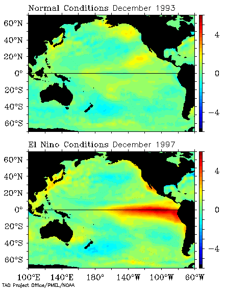
El Niño is defined as warmer than normal sea-surface temperatures (SSTs) in the tropical Pacific ocean that impact global weather patterns. This deviation from normal SSTs can have large scale impacts, not only on ocean processes, but also on the atmosphere. The graphic shown at the upper-left shows a normal SST pattern from December 1993, indicating no large scale deviations in the SST pattern.
The bottom graphic shows the SST pattern from December 1997 which happened to be during one of the largest El Niño events recorded during the 20th century. It is easy to see a large broad area of red, centered on the equator over the eastern Pacific Ocean. This area of red denotes SSTs which are 2-6 degrees warmer than normal values at that time of year. This is the signal that scientists look for when diagnosing El Niño events. As can be seen, the size of this warm pool of ocean water can be larger than the entire United States!
In normal, non-El Niño conditions (top panel of diagram to the left, land masses represented in brown), the trade winds blow toward the west across the tropical Pacific 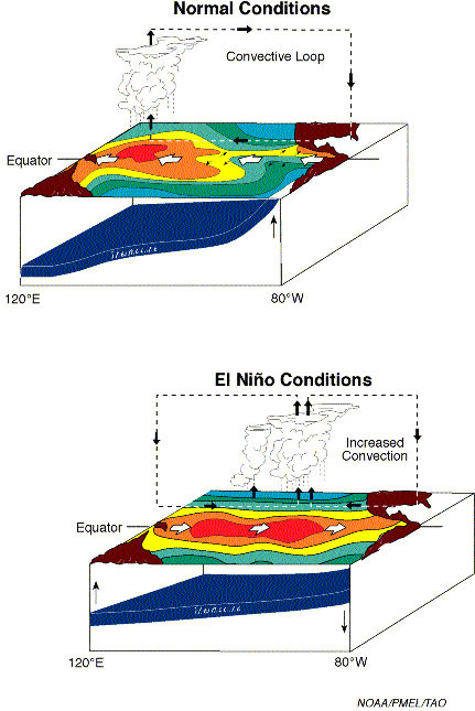 Ocean. These winds pile up warm surface water in the west Pacific, so that the sea surface is about 1/2 meter higher at Indonesia than at Ecuador.
The sea surface temperature is about 8 degrees C higher in the west, with cool temperatures off South America, due to an upwelling of cold water from deeper layers. This cold water is nutrient-rich, supporting a diverse marine ecosystem and major fisheries. Rainfall is found in rising air over the warmest water in the western Pacific, and the east Pacific is relatively dry. The diagram shows the typical convective loop with rising air over the western Pacific and sinking air over the eastern Pacific.
During El Niño (bottom panel of diagram to the left), the trade winds relax in the central and western Pacific leading to a movement to the east of the warm pool of water. This warm pool of water moves eastward until it spreads across the entire Pacific Ocean. The normally cool water located off the South American coast is replaced by much warmer waters, and without the trade winds, the upwelling which supplies the cooler sub-surface ocean water is weakened. This leads to the warm SSTs that were shown at the figure at the top of this webpage, with the strongest deviations from normal just off the South American coastline. Rainfall follows the warm water eastward, with associated flooding in Peru and drought in the normally wet regions of Indonesia and Australia. This eastward displacement of the atmospheric heat source overlaying the warmest water results in large changes in the global atmospheric circulation pattern as can be seen in the diagram. This large change in the circulation pattern in turn forces changes in weather in regions far removed from the tropical Pacific, such as Arizona.
El Niño means The Little Boy, or Christ Child in Spanish. This name was chosen based on the time of year in which the warm waters developed off the South American coast. El Niño was originally recognized by fishermen off the coast of South America in the 1600s, with the appearance of unusually warm water in the Pacific Ocean. This phenomenon typically occurred near the beginning of the year and meant that fishing would be more difficult due to the lack of nutrients brought up to the ocean surface by upwelling. Since fishing villages depended on the fish that were caught by the fishermen, these episodes were documented as harsh times for the villages due to lack of food and the prevalence of flooding rains.
As mentioned, El Niño has impacts that are felt not only near the equator, but far removed from the equator as can be seen in the figure to the left. A large area of dry and warm conditions are found in normally wet regions of the world such as Indonesia and Australia. Places that are normally dry, like western South America and the southwest United States tend to be much wetter than normal. Western Canada and Alaska along with portions of the Midwestern United States tend to enjoy a much warmer than normal winter as well. The southeast United States tends to experience wet and cool conditions throughout much of an El Niño winter.
The general effects of El Niño on northern Arizona tend to be felt most during the winter months. This is due to the stronger jet stream that typically occurs during the winter, when the effects of the warmer pool of water on the atmosphere are strongest. Across northern Arizona, El Niño winters tend to have more prolonged story periods with fewer and shorter dry breaks than normal. The storm track tends to have fewer storm systems originating from colder regions, and more originating from warmer regions with more moisture associated with them. Because of this, El Niño winters tend to be warmer and wetter than a normal winter across northern Arizona.
El Niño events tend to occur on average about every 3 to 5 years and typically last for a year. However, El Niño events can last for two years on occasion.
Impacts of El Niño and La Niña Events on Northern Arizona Weather![]()
Due to unequal heating of the equatorial regions versus the polar regions, temperature differences occur between the equatorial regions (receiving more heat energy) and the poles (receiving far less heat energy). This imbalance requires circulation patterns to develop which move heat from the tropics toward the poles, and move cool air from the poles toward the equator. Primary atmospheric mechanisms to reduce these temperature differences between the equator and poles include areas of low and high pressure systems and the development of clouds and winds to transport heat around the hemispheres. Persistent winds blowing on the ocean can cause upwelling and downwelling along coast lines, along with developing circulations throughout the oceans themselves. These circulation patterns, both in the atmosphere and the oceans, allow for heat energy to be transported throughout the Earth system. The ocean plays a large role in the atmospheric circulation pattern which determines our weather and our climate.
The jetstream is a fast flowing ribbon of air in the atmosphere that tends to be the primary mechanism which determines the weather pattern in a particular location. In the Northern Hemisphere, cold air tends to be located to the north of the jetstream with relatively warmer air located to the south of the jetstream. Thus, the jetstream tends to be located over areas where there is a strong contrast in temperature, which in weather jargon is called a front. When the right conditions exist, an area of low pressure can develop along the front, and act to relieve the temperature contrast by moving warm air from the south ahead of the low pressure system and moving colder air from the north behind the low pressure system. Low pressure systems are also the primary mechanism for the development of large areas of clouds and precipitation. Because the jet stream is the "steering current" for areas of low pressure, and also the primary location for the development of low pressure systems, in order to have stormy weather, you usually need to be near the jetstream.
Well, these temperature contrasts don't only exist over the land, but also exist in the oceans. As mentioned above, temperature contrasts occur in the tropical Pacific Ocean and differ during each phase of ENSO. It has been found that persistent thunderstorms primarily develop over warm waters, especially with temperatures greater than about 80 degrees F. This is the primary reason why hurricanes only develop in certain regions of the ocean at certain times of the year. In ENSO neutral years, as shown in the figure above, warm water is located primarily over western and central portions of the tropical Pacific Ocean, which keeps the persistent thunderstorm activity over this region. Anyone who has traveled to Indonesia and the islands of the western Pacific has experienced the typical daily thunderstorm activity that occurs there due to these warm waters. The persistent nature of these thunderstorms affects the atmospheric circulation by enhancing and anchoring the jetstream in a particular location, just like a rock in a creek creates patterns in the water downstream from it. The jetstream will then affect locations further downstream, such as the United States, with rain and snow storms during the winter season.
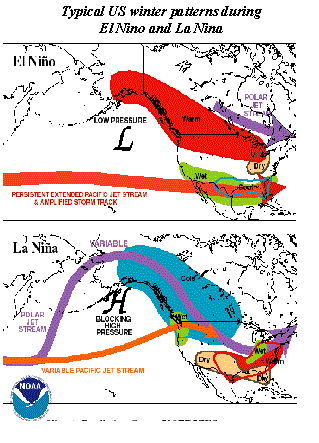
During El Niño events, the warm pool of water, which typically is located over only the western portions of the Pacific Ocean, spreads eastward toward South America. Eventually it covers the entire Pacific Ocean along the equator. This results in an eastward movement of persistent thunderstorm activity, which in turn leads to the energy from these thunderstorms shifting the jetstream pattern across the Pacific Ocean. As discussed above, the jetstream tends to be closely tied to locations where there is a temperature contrast. In El Niño events, this temperature contrast tends to be strongest near the central and eastern portions of the Pacific ocean, which tends to keep the jetstream stronger across the eastern Pacific Ocean and also displaced further south. As can be seen in the diagram to the left, this persistent jetstream tends to then affect the southern United States, including Arizona. A large area of low pressure tends to develop in the Gulf of Alaska which acts to supply the jetstream with additional energy to develop strong storms. Since storms tend to develop with and follow the jetstream, Arizona tends to get more storms, and thus, more precipitation opportunities under this particular pattern.
During La Niña events, colder than normal water exists over the central and eastern portions of the Pacific Ocean. This reduces the temperature difference of the ocean in this region which makes the likelihood of a persistent jetstream over the eastern portion of the Pacific Ocean less likely. As can be seen in the diagram, typically high pressure builds over the Gulf of Alaska, which sends the jetstream well north into Alaska and then southward into the Midwest of the United States. Occasionally, a portion of the jetstream will push through the ridge of high pressure to impact the western United States, especially the northwest coast. This leaves Arizona well removed from the jetstream, and thus leads to fewer storms, and less precipitation opportunities under this pattern.
There is year-to-year variability that occurs with precipitation and snowfall accumulation in the winter season for Flagstaff. There is also a relationship between sea surface temperatures in the Pacific Ocean and winter season precipitation in Flagstaff. During El Niño, the average precipitation recorded between 1971 and 2000 was 15.88" with 107.3" of snowfall during those years. During La Niña, there has been less precipitation and snowfall with 5.94" of precipitation and 58.1" of snowfall recorded during those years. During "normal" states of sea surface temperature, it can be seen that a wide range of precipitation and snowfall occur, which represents normal climate variability. El Niño and La Niña don't make it a 100% guarantee that it will be wetter or drier than normal, but they tend to tip the scales in that direction.

