
Thunderstorms and periods of heavy to excessive rainfall will continue over Florida through Thursday. Gusty winds and low humidity will promote elevated to critical fire weather conditions from central Georgia into north-central North Carolina Wednesday. A Kona Low is expected to bring strong winds, widespread heavy rainfall, and flooding concerns to the island chain through the weekend. Read More >


Media is free to use the NWS Flagstaff Event Summary information. Please acknowledge the NWS as the source of any information accessed from the site unless otherwise noted.
Mid-level moisture pushed into northern Arizona over the course of a couple days in mid-June 2021. Scattered thunderstorms developed in response to the moisture. These thunderstorms produced numerous lightning strikes, but very little rainfall in Yavapai County and along the Mogollon Rim into the White Mountains. The lightning from these storms ignited several wildfires throughout the region. These fires burned over 100,000 acres, mainly on state and federal public lands, into early July 2021. The largest two fires were the Rafael (around 78,065 acres) and the Backbone (around 40,855 acres). Numerous local, state and federal roads were closed as communities near Flagstaff, in the Verde Valley and throughout the Quad Cities experienced degraded air quality from smoke.
 Radar loop from 11 AM - 5 PM June 16, 2021 showing lightning strikes and high based thunderstorms moving across northern Arizona.
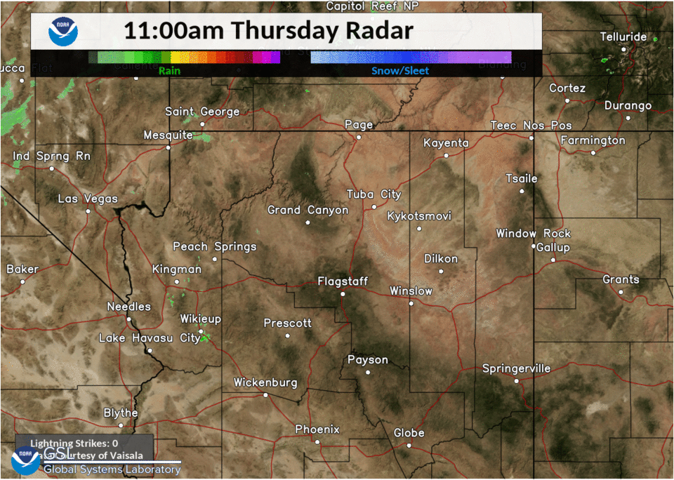 Radar loop from 11 AM - 5 PM June 17, 2021 showing lightning strikes and high based thunderstorms moving across northern Arizona.
The Rafael Fire was discovered on June 18, 2021 on the Prescott National Forest. The fire was located in a remote area approximately 4 miles north of Perkinsville and had grown to 1,000 acres by the morning of June 20. Strong winds on June 20, combined with dry fuels and favorable uphill topography in front of the fire, added nearly 18,000 acres for a total of 18,671 acres. The fire moved 9 ½ miles on June 20 and moved from the origin to above the Mogollon Rim onto the Kaibab National Forest and into the Sycamore Canyon Wilderness Area. On June 21, the fire added another approximately 5,500 acres to 24,191 acres, and burned actively in Tule Canyon within the Sycamore Canyon Wilderness on the Kaibab National Forest. The fire continued to grow in Sycamore Canyon and on Tuesday, June 22 the fire continued to move east and crossed into the Coconino National Forest. Again, topography and dry fuels drove the fire approximately 7 ½ miles on the 22nd and by Wednesday morning, and by the morning of June 23rd the fire had grown to 34,949 acres. The fire was at 78,065 acres in size by July 4, 2021.
The Backbone Fire started by lightning and was first reported at 11:30 PM MST on June 16, 2021. It started approximately 12 miles west of Pine and Strawberry, Arizona. Rough and rocky terrain coupled with limited area access along with excessive temperatures and single digit humidity created challenges for the approximately 100 personnel initially assigned to the fire. In addition, the Fossil Creek recreation area was closed due to wildfire danger, including Waterfall Trail, Irving/Flume, Tonto Bench, Fossil Creek Bridge, Homestead, Sally May, Purple Mountain, and Mazatzal. As of July 4, 2021, the fire was at 40,855 acres and 76% contained with 319 people assigned to the fire.
Red Hat Fire - Discovered 6/17: 49 acres
Limestone Fire - Discovered 6/17: 33 acres
Spring Fire - Discovered 6/19: 567 acres
Rock Butte Fire - Discovered 6/17: 127 acres
Silent Fire - Discovered 6/18: 27 acres
The Wyrick Fire was located 2 miles north, and the West Chev fire 12.25 miles northwest of Heber, AZ on the Apache-Sitgreaves National Forest. The fires were first reported on Saturday, June 19, 2021 around 12:30 PM MST. Ground crews, air tankers and helicopters worked to suppress the fires and protect the communities near Heber-Overgaard. The Wyrick Fire was around 7,592 acres, with the West Chev around 1,170 acres, in size by July 4, 2021.

The Backbone Fire on 6/21/2021 as seen from the Rim Country in Gila County. Image courtesy of Arizona Trail on Twitter

An aerial view of the Backbone Fire soon after ignition. Image courtesy of USFS on Inciweb
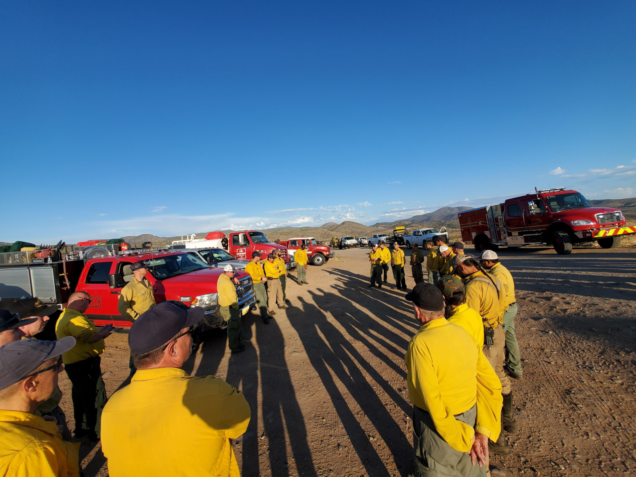
A division of the Type 1 Incident Management Team meeting for the Backbone Fire. Image courtesy of USFS on Inciweb

A crew of Hotshots working the Backbone Fire. Image courtesy of USFS on Inciweb

Overnight back burning on Backbone Fire on June 30, 2021. Image from Inciweb

Backbone Fire flames and smoke column on June 24, 2021. Image courtesy from Inciweb
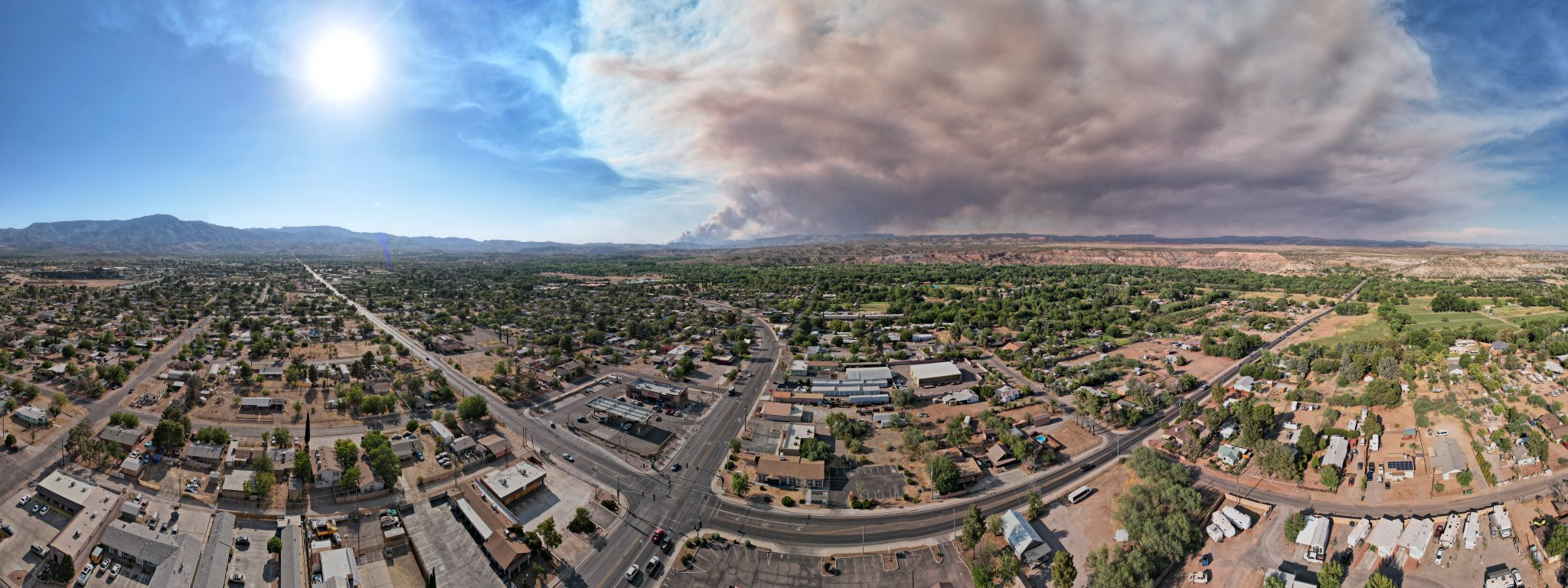
View of Rafael Fire as seen from Cottonwood looking northeastward towards the Mogollon Rim on 6/21/2021. Image courtesy of Verde Valley Video on Twitter

Rafael Fire in the afternoon hours on 6/21/21 looking over Sedona and the Red Rocks. Image courtesy of Danny Bavaro on Twitter

Smoke column billowing out of the Rafael Fire area. Image courtesy of Jessica Richardson on Inciweb

Heavy smoke impacted the greater Flagstaff, Verde Valley and Quad Cities areas. Image courtesy of Sean McLaughlin 3TV CBS on Twitter

Thick near-surface smoke from the Rafael Fire. Image courtesy of Ashleigh D'Antonio on Inciweb

Rafael Fire in the afternoon hours on 6/21/21 looking northward towards the Mogollon Rim. Image courtesy of Luke Vold on Twitter

The Fossil Creek Waterfall popular recreation area was spared for the Backbone Fire. Image courtesy of CNF on Flickr and taken on July 28, 2021

Very little regrowth in larger vegetation (trees and shrubs) had occurred in most areas of the Backbone Fire scar as of July 28, 2021. Image courtesy of CNF on Flickr

Some grasses had begun to regrow in the Backbone Fire scar area at the end of July 2021. Image courtesy of CNF on Flickr and taken on July 28, 2021

Limited grass regrowth in the Backbone Fire scar area at end of July 2021. Image courtesy of CNF on Flickr and taken on July 28, 2021
A very dry monsoon season in 2019 and 2020, along with extremely dry conditions in the fall of 2020 was only helped slightly by near-normal snowfall and cool-season precipitation in the winter of 2020-2021. This persistent and long-term lack of moisture across north-central and northeastern Arizona left much of the region in Extreme to Exceptional drought conditions by the spring of 2021. Those conditions were especially noted in very dry fuels (grasses, shrubs, small trees, etc.) in June 2021. By mid-June 2021 a weak push of moisture into northern Arizona helped to trigger scattered high-based thunderstorms (where most rainfall evaporates before it hits the ground). At least twelve fires were ignited by these storms, several of which spread through the very dry fuels, and grew quickly in favorable fire conditions (hot temperatures, gusty winds, and low humidity).
 Extreme to Exceptional drought across central and northern Arizona throughout 2020 and 2021 helped to create very dry fuel conditions for grasses, shrubs and other small trees or vegetation in June 2021.
 This Upper Air sounding at Bellemont, Arizona from 5 PM MST on June 16, 2021 shows mid-level moisture across northern Arizona creating elevated and dry thunderstorms. Lightning strikes from thunderstorms with elevated bases can be especially hazardous as very little, if any, rainfall reaches the ground after evaporation is accounted for under any storms.
For more information on impacts and general inquiries about this event, contact by sending an email to or by calling .

