
A widespread heat wave will peak over the South and East today, with several dozen temperature records expected along the East Coast. Heat should begin to ease this weekend in the Northeast, while hazardous heat continues over the South. Severe thunderstorms capable of damaging winds are possible across parts of the Appalachians, Mid Atlantic, and Northeast this afternoon and evening. Read More >


Media is free to use the NWS Flagstaff Event Summary information. Please acknowledge the NWS as the source of any information accessed from the site unless otherwise noted.
A series of three low pressure systems tracked across Arizona during a six day period from January 18th-23rd, 2010. These systems brought heavy snowfall to the higher elevations of northern Arizona, record flooding to our lower elevation locations, and strong winds area-wide. The third system in the series was (by far) the most intense, with record low pressure readings as it crossed the state on January 21st. Several snow and rainfall records were set throughout this week, with estimates of over 90 inches on the highest peaks of northern Arizona. Liquid precipitation amounts exceeded ten inches in some areas. It was truly a remarkable week of Winter weather.

Snowfall reports from around northern Arizona from January 18th - 23rd, 2010.
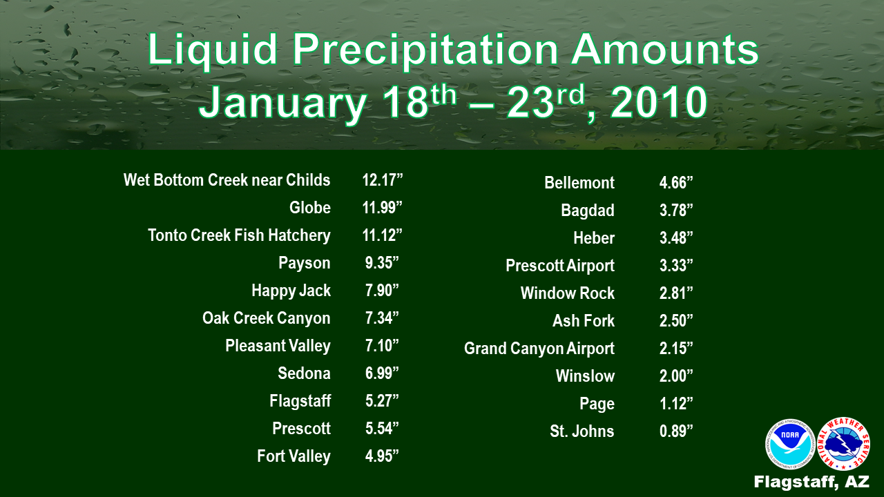
Liquid precipitation amounts from central and northern Arizona from January 18th - 23rd, 2010.
×
×

The roof at Jay Lively Ice rink collapsed due to the weight of the heavy snowfall. Photo Credit: Josh Biggs

The facades of both Bookmans and Joann Fabrics hang off the front of the building after the roof collapsed late in the day on Thursday January 21st, 2010. This was due to the weight of snowfall that had fallen. Photo Credit: Josh Biggs

Heavy snowfall led to deserted streets and closed businesses in downtown Flagstaff. Photo Credit: Deborah Lee Soltesz

Commercial flights out of Flagstaff Pulliam Airport were stopped at 8am Thursday January 21st due to deteriorating weather conditions. Photo Credit: Deborah Olin

The back deck of a Flagstaff resident buried under the storm's snowfall. Photo Credit: Bill Ferris

The aftermath of the storm as seen in Wildwood Hills Mobile Home Park in Flagstaff. Photo Credit: Coral Schooley

Many northern Arizona residents were forced to dig their cars out after the 5-day snowstorm. This photo is from the Heckethorn neighborhood off Lake Mary Road. Photo Credit: Mark Decker

Livestock around northern Arizona had to endure brutal winter weather conditions. Photo Credit: Fireground/Flickr

The Mogollon Rim Visitor Center in Payson received a substantial amount of snow throughout the storm. Photo Credit: Eric S. Neitzel

The National Guard delivered goods to rural areas across northern Arizona in the days following the storm. Photo Credit: Fireground/Flickr

Several feet of snow fell at the Arizona Nordic Village in Flagstaff. Photo Credit: Arizona Nordic Village

Rural areas saw some of the most significant impacts with residents stranded for days in their homes. Photo Credt: Fireground/Flickr
The first storm in the series of three occurred as a shortwave trough moved west to east across the state of Arizona. The Mogollon Rim provided the major lifting mechanism with this system as strong southwest flow lifted over the terrain. The precipitation was enhanced as the cold front associated with the trough became nearly stationary across the region. Mild southwesterly flow out ahead of a second, stronger trough led to snow levels rising to above 7,000 feet. As this second system and its associated cold front passed, snow levels then lowered again to around 5,000-5,500 feet. The third, and most significant, storm established some all-time record low pressure readings across sites in the Southwest United States, including at Phoenix Sky Harbor International Airport. This system brought with it very heavy precipitation and unusually high winds. The heavy precipitation posed a threat for the lower elevation areas as runoff from the previous two storms led to swollen rivers, creeks, and streams. Air travel was significantly hampered across the region due to a low level jet in excess of 80 knots around 4,500 feet above sea level. These strong winds combined with heavy snowfall brought blizzard conditions to the higher terrain of northern Arizona. A very strong cold front accompanied this system and led to the development of a line of thunderstorms which prompted the issuance of a Tornado Watch for most of southern Arizona. That was the first Tornado Watch issued in Arizona since 1993. Only one tornado was confirmed from the line of storms. Very cold air advected into the state behind the cold front with snow levels falling as low as 3,500 feet by the end of the system.

A very deep cold, low pressure system was centered off the northern California coast during this period with strong southwest flow pulling moisture into northern Arizona from the Pacific Ocean

A very strong jet stream associated with these three storm systems extended from the Central Pacific into the Desert Southwest
For more information on impacts and general inquiries about this event, contact by sending an email to or by calling .
Media is free to use this event summary information. Please acknowledge the National Weather Service as the source of any information accessed from the site unless otherwise noted.

