
Unseasonably warm temperatures continue through the weekend across the Southwest and southern U.S., with more than 100 record or near record maximum temperatures forecast through the rest of the week and over the weekend. Elevated to critical fire weather conditions will persist across the Plains and Southeast U.S. this weekend. Read More >


Media is free to use the NWS Flagstaff Event Summary information. Please acknowledge the NWS as the source of any information accessed from the site unless otherwise noted.
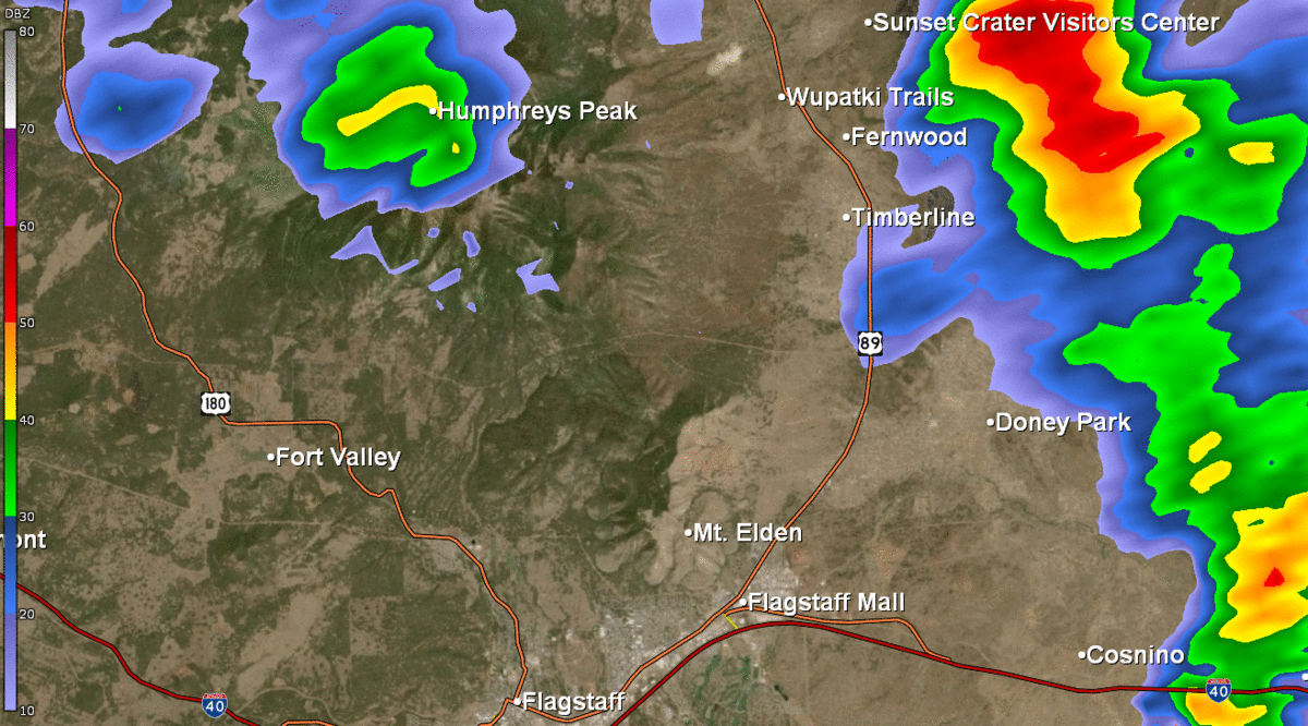
The Schultz Fire was started on June 20th, 2010 and burned over 15,000 acres of mountainous terrain northeast of Flagstaff in the San Francisco Peaks. The Burn Area Emergency Response team assessed that the 55% of the Schultz Fire Scar was severely burned. Significant monsoonal rainfall fell over the Schultz Fire scar on July 20th, 2010 and led to excessive runoff over the severely burned landscape. The runoff produced debris flows and flash flooding in communities downslope from the fire scar. The communities most affected were Wupatki Trails, Doney Park, Timberline, Hutchison Acres and Sunset Crater Estates. Trained spotters reported sheet flow depths between one and two feet, with areas near washes deeper. U.S. Highway 89 was closed for almost three hours to help with response to the flooding. One death was reported from this flooding event.

Map of the Schultz Fire burn scar area where heavy rainfall occurred on July 20th, 2010. Figure credit: USDA Forest Service, Schultz Fire BAER Report
Loop of half degree reflectivity from the KFSX radar (12:33 PM to 2:01 PM MST) showing Monsoon thunderstorms that produced the heavy rainfall over the Schultz Fire burn scar area on July 20th, 2010.
×
×

Clearing mud and debris leftover by flooding. Photo Credit: Arizona Daily Sun, Josh Biggs

Flood mitigation work for areas downslope of the Schultz Fire burn area was completed in the summer of 2015 after the flooding in 2010 occurred. Photo Credit: Arizona Daily Sun, Josh Biggs

Flooding impacted many of the yards of neighborhood houses. Photo Credit: Arizona Daily Sun, Josh Biggs

Clearing debris out of a drainage that was clogged during the flooding. Photo Credit: Arizona Daily Sun, Josh Biggs

A wall of flood water and debris hit this home. Photo Credit: Arizona Daily Sun, Josh Biggs

Debris and mud was forced into a house from the flooding. Photo Credit: Arizona Daily Sun, Josh Biggs

Debris and mud was forced into a house from the flooding. Photo Credit: Arizona Daily Sun, Josh Biggs
Flood waters and debris flows transported mud to the Chevron located at the intersection of U.S. Hwy 89 and Campbell Ave. Photo Credit: Arizona Daily Sun, Josh Biggs

Flood waters inundating the intersection of Campbell Ave and U.S. Hwy 89. Photo Credit: Eric S. Neitzel

Rocks were left on area roads after flood waters receded. Photo Credit: Arizona Daily Sun, Josh Biggs

A resident is trying to keep debris away from their home as flood waters rush through their backyard. Photo Credit: Arizona Daily Sun, Josh Biggs

Sheet flows flooded Landfill Road and adjoining areas on the south side of U.S. Hwy 89. Photo Credit: USFS, K. Koestner
The Schultz Fire burned along the eastern slopes on the San Francisco Peaks in June 2010. A hydrophobic soil layer was created on the Schultz Fire burn scar as a result of the fire. By late July, the Southwest monsoon season was in full effect with thunderstorms producing heavy amounts of rainfall. Eventually, a radar and gauge estimated one to three inches of rain fell across the Schultz Fire burn scar in the early afternoon of July 20th, 2010. The hydrophobic layer leftover by the fire aided in funneling the rainfall into drainages that flow eastward out of the fire scar. The flowing drainages and washes eventually produced flash floods and debris sheet flows as banks were overtopped. The flash floods and debris sheet flows swept through the communities of Wupatki Trails, Doney Park, Timberline, Hutchison Acres and Sunset Crater Estates located on either side of highway 89 northeast of Flagstaff.
For more information on impacts and general inquiries about this event, contact by sending an email to or by calling .
Media is free to use this event summary information. Please acknowledge the National Weather Service as the source of any information accessed from the site unless otherwise noted.

