Let's take a look back at the 2014-2015 Winter season.
Quick Seasonal Summary
December 2014
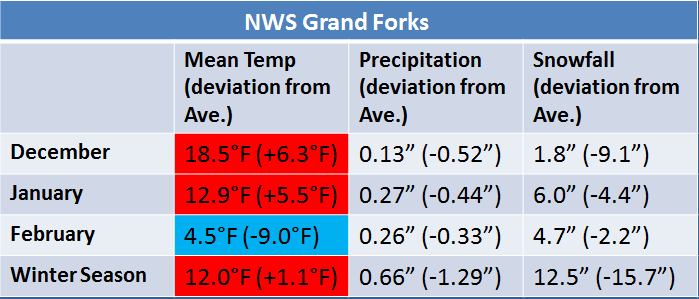
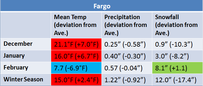
In terms of temperature, December 2014 was 6.3 degrees above average in NWS Grand Forks and 7.0 degrees above average in Fargo. This past December was almost 18 degrees warmer than last December in Grand Forks, and 17 degrees warmer in Fargo. Several records for warmest daily minimum temperatures were set at both Grand Forks and Fargo during the month.
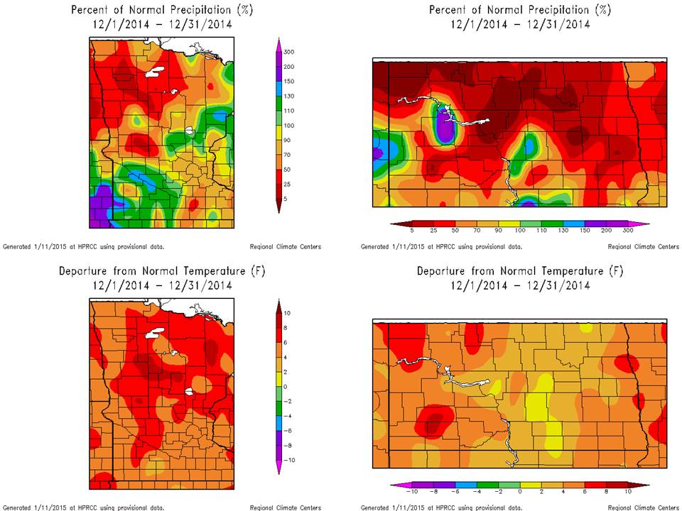
Most of the region saw below average precipitation during December, with some areas less than 50% of normal precipitation during this time. Only 0.13 inches of precipitation fell at the NWS in Grand Forks in December with just 1.8 inches of snowfall. It was around the 10th least snowy December for the site. Fargo received 0.25 inches of precipitation and only 0.9 inches of snowfall in December, tying for the third least snowy December on record. Below are images indicating the percent of normal precipitation and departure from normal temperature for December 2014 in North Dakota and Minnesota from the High Plains Regional Climate Center.
January 2015
The trend of predominantly above average temperatures continued in January, with the month winding up 5.5 degrees above average in Grand Forks and 6.7 degrees above average in Fargo (11 to 12 degrees warmer than last January). This was after a relatively cold start to the New Year in early January.
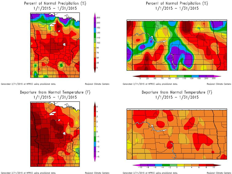
A bit more precipitation occcurred closer to the international border over northwestern Minnesota during January, as seen in the top left of the image below. In January, 0.27 inches of precipitation fell in Grand Forks, including 6.0 inches of snowfall. In Fargo, 0.40 inches of precipitation occurred, with only 3.0 inches of snowfall. Once again, below are images indicating the percent of normal precipitation and departure from normal temperature for January 2015 in North Dakota and Minnesota.
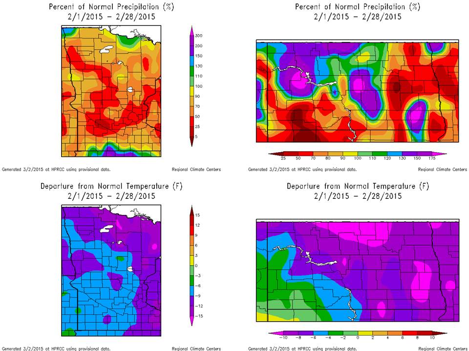
February 2015
A dramatic change occurred in February as compared with December and January, in terms of temperature. However, significant variability in temperature or precipitation patterns is common in our region, even within a season. Several persistent cold snaps resulted in monthly deviations well below average, with the NWS in Grand Forks finishing the month 9.0 degrees below average. Grand Forks failed to rise above the freezing mark on any day during the month. Fargo ended up 6.9 degrees below average for the month. As cold as the month may have seemed, especially after the milder start to Winter, this February averaged about 2 to 3 degrees warmer at Grand Forks and at Fargo compared with last February.
Precipitation varied across the region in February, with the main precipitation system for the month occurring on February 10. Fargo recorded nearly 0.40 inches of precipitation for the date, including 3.5 inches of snow, which was the latest date during the Winter season for the first one inch or greater snowfall in a calendar day on record for the site. As a result of this system, Fargo ended the month near average for precipitation and snowfall. Grand Forks was drier, with just over one quarter inch of precipitation. This was 0.33 inches below average. Around 5 inches of snow fell during the month at Grand Forks, which is about 2 inches below average. The images below are similar to those above, except for February 2015.
* The information described here is all considered preliminary. Final, official quality-controlled data is available through NCDC/NCEI.

