Grand Forks, ND
Weather Forecast Office
An anomalous weather system for the middle of summer tracked across southern Canada leading to very strong winds across North Dakota on Monday. The strongest winds occurred across western and central North Dakota where wind gusts in excess of 70 mph were reported. Into eastern North Dakota, wind gusts up to 59 mph occurred within the Devils Lake basin, with most areas observing wind gusts of 40 to 50 mph. Several reports of damage due to the strong winds were received, including downed trees.
Water Vapor Imagery
The animation below shows the strong circulation in the upper levels of the atmosphere as it crossed from southern Manitoba into Ontario.
Surface Observations/Sea Level Pressure
Highest Wind Speeds

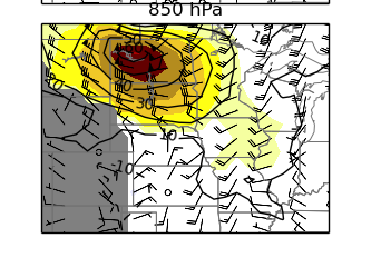
How unusual is this type of event for late July?
Although it is typical to get strong winds gusts in July associated with thunderstorms, it is quite unusual to see such strong winds associated with a synoptic (large scale) weather system. Such a weather system would more typically occur later in the Fall through the Winter and into the Spring. To put this in perspective, looking at the 1979-2009 climatology, and using wind speeds around 850mb (3000-3500 feet above the surface) as a proxy for the strength of this system, these wind speeds have never happened within this 30-year period during this time of year. Looking at this from another angle, the 850mb wind speeds were roughtly 6 standard deviations from the mean, which related to a probability of occurrence near 0.001% for this time of year!
00Z (7pm) 850mb wind speed and Standard Anomaly
US Dept of Commerce
National Oceanic and Atmospheric Administration
National Weather Service
Grand Forks, ND
4797 Technology Circle
Grand Forks, ND 58203-0600
701-772-0720
Comments? Questions? Please Contact Us.

