Overview
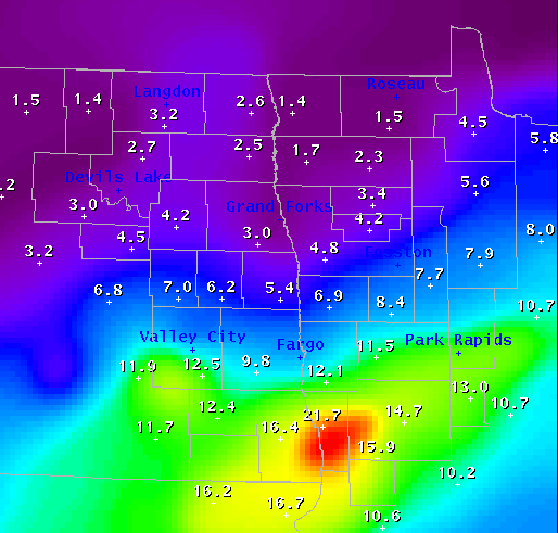
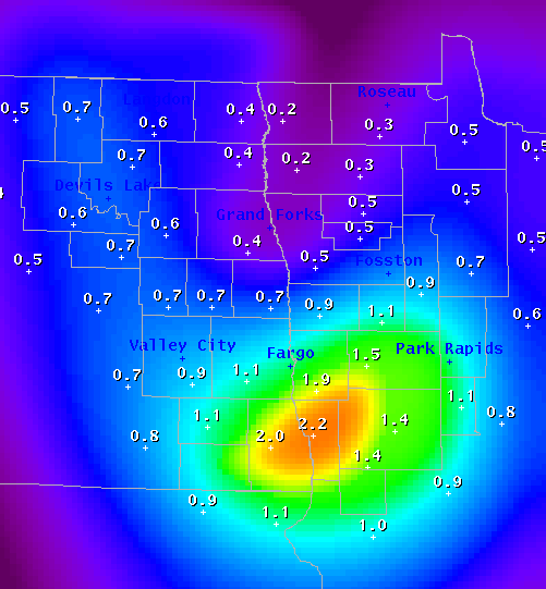
A large storm system affected the northern plains Monday and Tuesday, producing significant snowfall of over 1 foot from southeast North Dakota into west central Minnesota. There was significant snow banding that occurred during this winter storm, producing local variations in snow amounts. The highest snow total was 27 inches in Campbell, MN in Wilkin County. The heaviest snow fell along and south of the Interstate 94 corridor, with lighter amounts further north. In addition, significant liquid equivalent precipitation was contained in the heavy/wet snow, and some areas received more than 2 inches of liquid in the snowpack in the southern Red River Valley. Below are the preliminary estimates of the total snowfall and liquid precipitation equivalent maps.
Snow Totals
Header
 |
 |
| Two-Day Snow Totals (in.) March 30-31 |
Equivalent Liquid Precipitation (in.) March 30-31 |
Storm Reports
HEAVY SNOW REPORTS
LOCATION SNOW FALL TIME/DATE
(INCHES) OF OBSERVATION LAT LON
MINNESOTA
...BECKER COUNTY...
DETROIT LAKES 11.0 E 638 PM 03/31 46.81N 95.84W
FRAZEE 18.0 E 432 PM 04/01 46.73N 95.70W
...CLAY COUNTY...
SABIN 10.3 M 600 AM 04/01 46.78N 96.65W
...OTTER TAIL COUNTY...
4 N NEW YORK MILLS 12.0 E 700 PM 03/31 46.58N 95.37W
NEW YORK MILLS 12.0 M 700 AM 04/01 46.52N 95.37W
PELICAN RAPIDS 15.0 E 938 PM 03/31 46.57N 96.09W
PELICAN RAPIDS 16.0 M 700 AM 04/01 46.57N 96.09W
PHELPS 16.0 M 1100 AM 04/01 46.38N 95.82W
...WADENA COUNTY...
WADENA 14.0 E 726 PM 03/31 46.44N 95.13W
...WILKIN COUNTY...
ROTHSAY 19.0 M 700 AM 04/01 46.47N 96.29W
CAMPBELL 27.0 M 700 AM 04/01 46.10N 96.41W
LOCATION SNOW FALL TIME/DATE
(INCHES) OF OBSERVATION LAT LON
NORTH DAKOTA
...SARGENT COUNTY...
HAVANA 14.0 M 700 AM 04/01 45.95N 97.62W
MINNESOTA
...HUBBARD COUNTY...
12 N PARK RAPIDS 12.0 E 445 PM 03/31 47.09N 95.06W
...ROSEAU COUNTY...
WARROAD 2.7 M 1200 AM 04/01 48.91N 95.32W
NORTH DAKOTA
...CASS COUNTY...
FARGO 10.3 M 700 PM 03/31 46.88N 96.82W
...RAMSEY COUNTY...
STARKWEATHER 2.0 E 700 PM 03/31 48.45N 98.88W
...WALSH COUNTY...
LANKIN 5.0 M 700 AM 04/01 48.31N 97.92W
 |
Media use of NWS Web News Stories is encouraged! Please acknowledge the NWS as the source of any news information accessed from this site. |
|

