Overview
Another clipper system caused blowing snow and wind gusts up to 55MPH, reducing visibilities and shutting down roads.Wind:
Public Information Statement
National Weather Service Grand Forks ND
638 AM CST Sun Feb 20 2022

...PRELIMINARY STRONGEST WIND GUSTS AS OF 630AM...

Location                     Speed     Time/Date       Provider
Grand Forks AP ND            53 MPH    0511 AM 02/20   ASOS
E Grand Forks MN 6 SE        51 MPH    0535 AM 02/20   MNDOT
Cooperstown AP ND            49 MPH    0555 AM 02/20   AWOS
Grand Forks ND AFB           48 MPH    0510 AM 02/20   ASOS
Hendrum MN 4 ENE             48 MPH    0548 AM 02/20   MNDOT
Cando AP ND                  47 MPH    0535 AM 02/20   AWOS
Eldred MN 2 W                45 MPH    0625 AM 02/20   NDAWN
Warren MN 6 SW               45 MPH    0605 AM 02/20   NDAWN
Hampden ND 3 SE              45 MPH    0458 AM 02/20   RAWS
Grafton AP ND                45 MPH    0255 AM 02/20   AWOS
Emerado US 2 MP 340.4        45 MPH    0557 AM 02/20   NDDOT
Grand Forks I-29 MP 145      45 MPH    0512 AM 02/20   NDDOT
Leeds ESS,US-2               45 MPH    0246 AM 02/20   NDDOT
Edmore ND 3 NW               44 MPH    0435 AM 02/20   NDAWN
Logan Center ND 2 E          44 MPH    0425 AM 02/20   NDAWN
Donaldson MN 1 W             44 MPH    0620 AM 02/20   MNDOT
Bowesmont I-29 MP 196        44 MPH    0316 AM 02/20   NDDOT
Mayville ND 2 E              43 MPH    0610 AM 02/20   NDAWN
Prosper ND 5 NW              43 MPH    0625 AM 02/20   NDAWN
Langdon AP ND                43 MPH    0455 AM 02/20   AWOS
Fargo AP ND                  43 MPH    0629 AM 02/20   ASOS
Galesburg ND 4 SSW           42 MPH    0605 AM 02/20   NDAWN
Finley ND 1 NNW              42 MPH    0540 AM 02/20   NDAWN
Buffalo ND 38 MP 10          42 MPH    0542 AM 02/20   NDDOT
Ada MN 1 N                   41 MPH    0600 AM 02/20   NDAWN
Kennedy MN 6 W               41 MPH    0450 AM 02/20   NDAWN
Cando ND 2 SE                41 MPH    0545 AM 02/20   NDAWN
St Thomas ND 2 WSW           41 MPH    0625 AM 02/20   NDAWN
Crookston AP MN              41 MPH    0615 AM 02/20   AWOS
Devils Lake AP ND            41 MPH    0514 AM 02/20   AWOS
Baker ND 1 N                 40 MPH    0325 AM 02/20   NDAWN
Crary ND 1 E                 40 MPH    0505 AM 02/20   NDAWN
Inkster ND 3 W               40 MPH    0500 AM 02/20   NDAWN
Kempton ND 6 SE              40 MPH    0415 AM 02/20   NDAWN
Pekin ND 2 NE                40 MPH    0420 AM 02/20   NDAWN
Walhalla AP ND               40 MPH    0355 AM 02/20   AWOS


Observations are collected from a variety of sources with varying
equipment and exposures. We thank all volunteer weather observers
for their dedication. Not all data listed are considered official.

$$
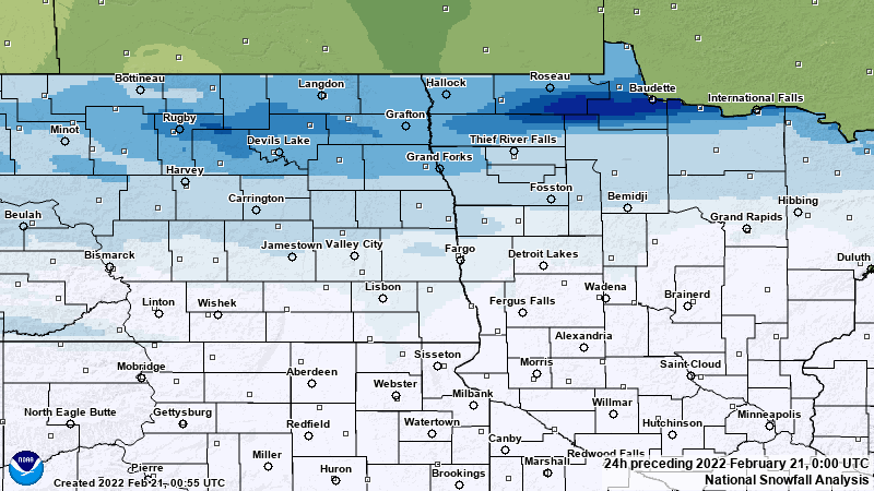
Snow/Ice
NOHRSC Snowfall Analysis from the 24 hours preceding 6 PM February 20th, 2022. The northern valley were the winners in this event once again, with anywhere from 1 to 4 inches.
 |
Photos & Video
Above: Video from UND Skycam (East) on February 20th, 2022
A look at the noontime NDAWN webcams in the RRV... Scattered Blowing Snow / Freezing Fog continues. Visibilities about 1/2 mi in plumes and 1-5 miles outside of them. #ndwx pic.twitter.com/TAOniZrWj3
— NDAWN (@NDAWNmesonet) February 20, 2022
Winds have started to show signs of weakening across the northern Red River valley, but reduced visibilities down to 1/4 of a mile in open country continue to be an issue. Look for improved conditions by the late afternoon. #mnwx #ndwx pic.twitter.com/iIyIVIkcF4
— NWS Grand Forks (@NWSGrandForks) February 20, 2022
(Feb. 20 at 8:00 a.m.) âš ï¸UPDATEâš ï¸ A Travel Alert has been extended to Devils Lake area. A Travel Alert is also in place for Griggs, Steele, Cass and Traill Counties.
— NDDOT (@NorthDakotaDOT) February 20, 2022
No Travel Advisory in place for Grand Forks and surrounding areas.
Drive carefully and #KnowBeforeYouGo. pic.twitter.com/ORRh2kqGJE
2/20_ 7am- Hwy 2 from Crookston to ND is closed. Many NW MN hwy's -no travel advised due to whiteout conditions. Check https://t.co/tRGmxvnkZA for latest road conditions. Travel may still be difficult on county, township and municipal roads. Check your local road conditions. pic.twitter.com/7piqbu9G1W
— MnDOT District 2 (@MnDOTnorthwest) February 20, 2022
Beautiful drive on the I-29 south this morning from north Dakota, hopefully it lets up. pic.twitter.com/J8iDsGGjhR
— Captain_Cracked (@Captain_cracked) February 20, 2022
Radar
Radar Imagery from 9PM on the 19th to 9AM on the 20th
 |
Media use of NWS Web News Stories is encouraged! Please acknowledge the NWS as the source of any news information accessed from this site. |
|

