Overview
|
In early Fall 2008, several large storm systems moved across the region, producing showers and thunderstorms, some with excessive rain amounts. As a result, the top soil was quite saturated in many locales. Fall harvest was slowed or stopped, and some rivers were seeing rare late season flooding. Based on preliminary data, this was the 2nd wettest fall so far on record at the University of North Dakota/NWS Climate Station, and the 2nd wettest in Fargo. It is because of the record precipitation and above normal snowfall that NOAA's NWS was alerting the residents of the Red River Valley of the North of the potential of major flooding this 2009 spring. |
 Caption |
Flooding
The fall months of September through November 2008 were the wettest of record in both Fargo and Grand Forks. After the wet fall season, moderate to heavy snowfall occurred, with the higher amounts in the southern Red River Valley, Upper Sheyenne River and Devils Lake Basins. While the wet fall, on its own, is not an indicator to significant spring flooding, the additional of heavy winter snowfall is a second important factor.
As a result, the North Central River Forecast Center (NCRFC) in Chanhassen indicated the likelihood of significant river flooding this spring season. Residents were advised to consult "Anatomy of a Red River Spring Flood" by Senior Meteorologist Al Voelker. Although it was written quite a few years ago, the article is still very relevant. One other factor that is also critical, and not covered by the current article, is Land Use Modifications.
In the past 40 years through 2008, there were 4 major flood events in the Red River Valley of the North. The spring floods of 1969, 1979, 1989 and 1997 were devastating, each one having a greater impact than the previous one. Research by the U.S. Army Corps of Engineers has identified one of the more significant contributors to flooding on the Red River. Land Use Modifications including the enlarging of ditches, development of diking, and extra drainage allows water to reach the main-stem Red River more quickly than before. As a result, residents of the Red River Valley proper have seen higher flood levels with lower amounts of precipitation. The basic premise of Mr. Voelker's remains valid; a wet fall, heavy winter snows, late and/or rapid melt along with rainfall near the melt are significant factors contributing to major flooding. The four years mentioned above had some or all those factors come into play.
The development of the Advanced Hydrologic Prediction Services (AHPS) incorporates all these factors and more into the prediction of river levels. This has allowed the NWS and our partners in the Emergency Management community, flood fighters and those whose jobs are to protect life and property, a tool to better assess the probability for flooding weeks and months in advance.
Wet 6 Months
Below are tables that rank the 10 highest snowfall and liquid precipitation periods in Fargo and Grand Forks, between September 1st through February 28th, as of 2008. These are preliminary data from the National Climatic Data Center and subject to modifications at a later date. However, they did indicate the Fargo and Grand Forks area are experiencing the wettest six month fall and winter period on record. It is critical to note that this is in large part due to the record wet fall months of September - November 2008. It is also important to note that the seasonal snowfall to date is in 10th place for Fargo, but not in the top 10 for Grand Forks.
| Fargo Area | |||||||
| Total precipitation Sep-Feb | Total snowfall Sep-Feb | ||||||
| Years 1885 - 2009 | Years 1885 - 2009 | ||||||
| Rank | Value | Year | Missing | Rank | Value | Year | Missing |
| 1 | 14.31 | 2009 | 1 | 83.4 | 1997 | ||
| 2 | 12.15 | 1897 | 2 | 71.5 | 1897 | ||
| 3 | 12.00 | 1904 | 3 | 66.1 | 1994 | ||
| 4 | 11.61 | 1972 | 4 | 63.4 | 1937 | ||
| 5 | 11.36 | 2001 | 5 | 60.3 | 1989 | (1) | |
| 6 | 11.34 | 1978 | 6 | 59.4 | 1996 | ||
| 7 | 11.25 | 1882 | 7 | 55.3 | 1982 | ||
| 8 | 11.11 | 1883 | 8 | 53.8 | 1907 | ||
| 9 | 11.02 | 2005 | 9 | 52.6 | 1986 | ||
| 10 | 10.58 | 1999 | 10 | 51.2 | 2009 | ||
| Grand Forks Area | |||||||
| Total precipitation Sep-Feb | Total snowfall Sep-Feb | ||||||
| Years 1893 - 2009 | Years 1893 - 2009 | ||||||
| Rank | Value | Year | Missing | Rank | Value | Year | Missing |
| 1 | 13.12 | 2009 | 1 | 76.8 | 1996 | ||
| 2 | 10.26 | 1982 | 2 | 69.9 | 1997 | (6) | |
| 3 | 10.11 | 1974 | 3 | 64.0 | 1989 | ||
| 4 | 9.37 | 1966 | 4 | 62.6 | 1986 | ||
| 5 | 9.24 | 1999 | 5 | 59.0 | 1999 | ||
| 6 | 9.15 | 1978 | 6 | 50.5 | 1994 | ||
| 7 | 9.05 | 2001 | 7 | 50.3 | 1956 | ||
| 8 | 9.02 | 1932 | (5) | 8 | 48.5 | 2004 | |
| 9 | 9.01 | 1901 | 9 | 44.7 | 1948 | (1) | |
| 10 | 8.52 | 1996 | 10 | 44.5 | 1936 | (2) | |
The numbers in parenthesis indicate the number of missing days during the period indicated.
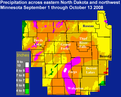
Early Fall Rainfall
Below is a table of the top 10 wettest September 1 through October 15 for Fargo and Grand Forks.
Fargo Hector Field
Rain totals September 1 through October 15, 2008
Based on Preliminary data
Rank Value Ending Date
1 9.24 10/15/1903
2 8.63 10/15/2008
3 8.09 10/15/1982
4 7.52 10/15/1957
5 7.25 10/15/1999
6 6.44 10/15/1973
7 6.27 10/15/1889
8 6.26 10/15/1904
9 6.08 10/15/1881
10 5.99 10/15/1984
University of North Dakota/NWS
Climate station
Rain totals September 1 through October 15, 2008
Based on Preliminary data
Rank Value Ending Date
1 9.22 10/15/1957
2 9.20 10/15/2008
3 7.19 10/15/1973
4 7.03 10/15/1912 – some missing data
5 6.57 10/15/1950
6 6.55 10/15/1961
7 6.46 10/15/1981
8 6.25 10/15/1982
9 5.78 10/15/1900
10 5.67 10/15/1941 – some missing data
Below are totals for the same period based on local rain reports.
...FROM NDAWN (NORTH DAKOTA AGRICULTURE WEATHER NETWORK) SITES...
OCT 9-13 SEPT 1-13
ADA 1N (NORMAN CO. MN)...................1.84 9.52
BAKER 1N (BENSON CO. ND).................1.64 4.45
CANDO 2SE (TOWNER CO ND).................1.48 5.68
CAVALIER 5W (PEMBINA CO ND)..............1.72 8.98
CRARY 1E (RAMSEY CO ND)..................1.27 6.11
DAZEY 2E (BARNES CO ND)..................1.61 4.93
EKRE (RICHLAND CO ND)....................3.17 8.06
ELDRED 2W (POLK CO MN)...................3.46 7.50
FARGO - NDSU (CASS CO ND)................2.57 8.51
FINGAL 4W (BARNES CO ND).................2.29 7.45
FOREST RIVER 7WNW (WALSH CO ND)..........1.37 5.67
GALESBURG 4SSW (CASS CO ND)..............1.55 4.48
GRAFTON 12E (WALSH CO ND)................1.16 4.65
GRAND FORKS 3S (GRAND FORKS CO ND).......1.76 7.42
GREENBUSH 7W (ROSEAU CO MN)..............1.25 5.69
HILLSBORO 7SE (TRAILL CO ND).............1.93 8.24
HUMBOLDT 4S (KITTSON CO MN)..............1.04 5.31
LANDGON 1E (CAVALIER CO ND)..............1.34 5.79
LEONARD 5N (CASS CO ND)..................2.99 8.92
LIBSON 2W (RANSOM CO ND).................3.02 7.30
MAVIE 3WSW (PENNINGTON CO MN)............2.00 7.66
MAYVILLE 2E (TRAILL CO ND)...............1.72 6.12
MCHENRY 8N (EDDY CO ND)..................1.59 7.08
MICHIGAN 2W (NELSON CO ND)...............1.38 6.55
PERLEY 6E (NORMAN CO MN).................1.94 9.01
PILLSBURY 1N (BARNES CO ND)..............1.85 6.69
PROSPER 5NW (CASS CO ND).................2.44 10.50
ROSEAU 11S (ROSEAU CO MN)................1.44 4.91
SABIN 2 NE (CLAY CO MN)..................2.78 8.64
ST THOMAS 2WSW (PEMBINA CO ND)...........1.21 6.42
STEPHEN 8ENE (MARSHALL CO MN)............1.25 5.69
WAPHETON 6N (RICHLAND CO ND).............3.42 9.11
WARREN 6SW (POLK CO MN)..................2.01 7.54
WYNDMERE 2E (RICHLAND CO ND).............3.55 9.98
...AREA AIRPORT ASOS/AWOS RAINFALL TOTALS FOR SEPT 1 TO OCT 13...
BAUDETTE ASOS............6.60
FARGO ASOS...............8.63
GRAND FORKS ASOS.........8.35
PARK RAPIDS ASOS.........7.46
BEMIDJI AWOS.............NOT AVAILABLE
DETROIT LAKES AWOS.......6.86
DEVILS LAKE AWOS.........6.64
ELBOW LAKE AWOS..........4.67
FERGUS FALLS AWOS........5.80
FOSSTON AWOS.............8.54
GFK AIR FORCE BASE ASOS..7.19
HALLOCK AWOS.............4.75
JAMESTOWN ASOS...........4.87
ROSEAU AWOS..............4.90
STAPLES AWOS.............6.36
THIEF RIVER FALLS AWOS...6.74
WADENA AWOS..............4.40
WAHPETON AWOS............NOT AVAILABLE
WASKISH AWOS.............4.62
NWS GRAND FORKS OFFICE...9.20
 |
Media use of NWS Web News Stories is encouraged! Please acknowledge the NWS as the source of any news information accessed from this site. |
|

