Overview
Comparing the number of blizzards over the years within the Red River Valley of the North (eastern North Dakota, northwest and west-central Minnesota) can be tricky. However, this webpage will attempt to compare winter seasons with the most blizzards in our period of record, as well as other notable aspects when comparing seasons. Refer to the tabs below to explore!
*The content of this webpage is valid as of December 31, 2022.
Blizzard Climatology:
The National Weather Service defines a blizzard as a hazardous weather condition that is comprised of winds of at least 35 mph and considerable falling and/or blowing snow leading to visibility reductions of a quarter mile or less, both lasting together for 3 or more hours.
Research has been conducted to compile the number and characteristics of blizzards within the Red River Valley of the North between the 1979-1980 and 2017-2018 seasons, a total of 39 winter seasons. This research concluded that the Red River Valley of the North averages 2.6 blizzards per year. As of December 2022, the season with the most blizzards is the 2021-2022 season at 12, outpacing 2013-2014 and 1996-1997 seasons with 10 blizzard episodes.

"Alberta Clippers" and the 2021-2022 Winter Season
An "Alberta Clipper" as defined by the National Weather Service is a fast moving low pressure system that moves southeast out of Canadian Province of Alberta (southwest Canada) through the Plains, Midwest, and Great Lakes region usually during the winter. This low pressure area is usually accompanied by light snow, strong winds, and colder temperatures.
It is difficult to know how many Alberta Clippers have impacted the Red River Valley of the North as the National Weather Service does not keep a climatological record of these phenomena. However, one study suggests that for a typical winter season (October-March) this region averages around 12 impactful clippers, with January-February period averaging around 5 impactful clipper events. Comparing this study to subjective analysis by meteorologists at the National Weather Service Grand Forks office on the 2021-2022 winter season, some conclusions can be made:
In summation, we have had 11 impactful clipper systems this season, of which 6 have been blizzard episodes. In other words, 6 of our 12 blizzards this season have come from Alberta Clippers. Considering we typically average around 12 impactful clipper events per season, we are on track to be near average (if the pattern ceases to bring additional impactful clipper systems over the region). However, we typically average around 5 impactful clipper events during the months of January and February, so the persistence of this pattern during January-February months is very unusual.

1996-1997 vs 2021-2022 Blizzards
Since the 2021-2022 winter season is outpacing the infamous 1996-1997 winter season in terms of number of blizzards, it is understandable to compare the two seasons and its implications on potential spring snowmelt flood. However there are key differences between the two seasons: types of blizzards and snow amount.
Using this research to define "types" of systems that usually produce blizzards for our region, we can break down blizzards into four categories: Colorado Lows, Hybrids, Alberta Clippers, and Arctic Cold Fronts. Each type typically carry with them different levels of impacts, durations, and snow amounts.
Here is a breakdown of each season and their associated blizzard types:
1996-1997 had 5 Colorado Low/Hybrid blizzards, 4 Clipper/arctic blizzards, 1 south wind blizzard.
Nov. 16 Colorado
Dec. 17 Clipper
Dec. 20 Clipper/Arctic
Dec. 31 South Wind
Jan. 4 Colorado
Jan. 9 Clipper
Jan 15 Clipper/Arctic
Jan 21 Hybrid/Colorado
March 4 Colorado
April 5 Colorado
2021-2022 has seen 5 Hybrid/Colorado Low blizzards and 6 Clipper/arctic blizzards (thus far)
Dec 4-5 Hybrid
Dec. 26-27 Hybrid
Jan 4-5 Hybrid
Jan 7-9 Clipper
Jan 18 Clipper
Jan 30-Feb 1 Clipper
Feb 11 Clipper/Arctic
Feb 18 Clipper
Feb 20 Clipper/Arctic
Feb 21 Hybrid/Colorado low
Feb 22 Hybrid/Colorado low
Apr 12-13 Colorado low
Essentially, the 1996-1997 winter season blizzards were comprised of mostly Colorado Low systems, whereas the 2021-2022 winter season blizzards have mostly been Alberta Clipper systems. Colorado Lows will usually produce more snow and have longer duration blizzard conditions over our region when compared to Alberta Clippers which produce less snow with shorter duration blizzard conditions.
 |
 |
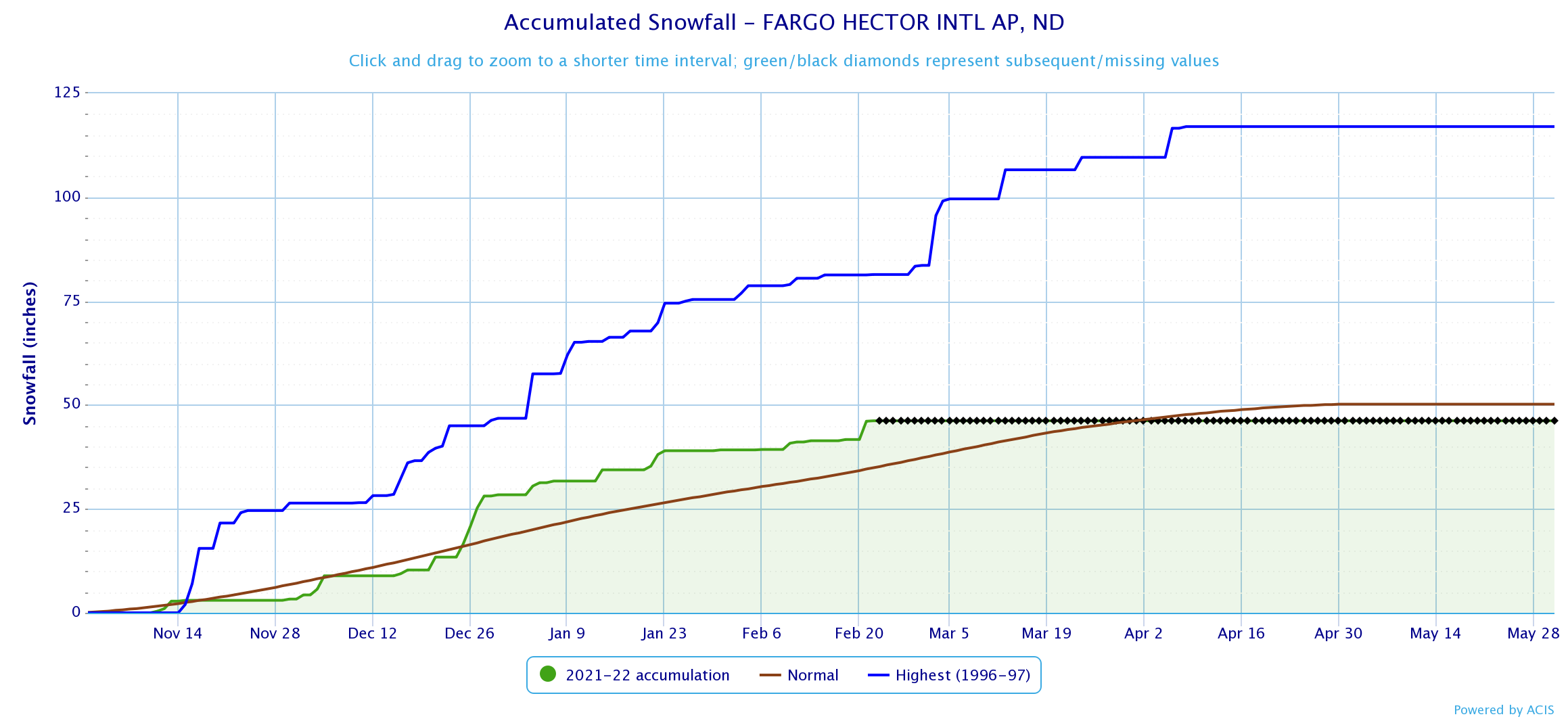
| Snowfall accumulation graphic for NWS office in Grand Forks,ND. Blue line = 1996-1997 snow accumulation. Green line = 2021-2022 snow accumulation (thus far). Brown line = average snow accumulation. | Snowfall accumulation graphic for Hector International Airport in Fargo, ND. Blue line = 1996-1997 snow accumulation. Green line = 2021-2022 snow accumulation (thus far). Brown line = average snow accumulation. |
As the graphs above show, the 1996-1997 season exceeds the 2021-2022 season snow amount by around 30 inches (as of February 23, 2022). While the 2021-2022 snow accumulation lags the infamous 1996-1997 season, it is still already above normal. If you are curious on how this season's snow accumulation across the region relates to spring snowmelt flood potential, please visit the latest flood outlook for the Red River Valley of the North basin as well as the Devils Lake basin.
 |
Media use of NWS Web News Stories is encouraged! Please acknowledge the NWS as the source of any news information accessed from this site. |
 |