Overview
Blizzard conditions developed within portions of the Red River Valley and Devils Lake Basin as a strong low pressure system moved into the Upper Midwest February 14-15, 2023.Impacts
 |
 |
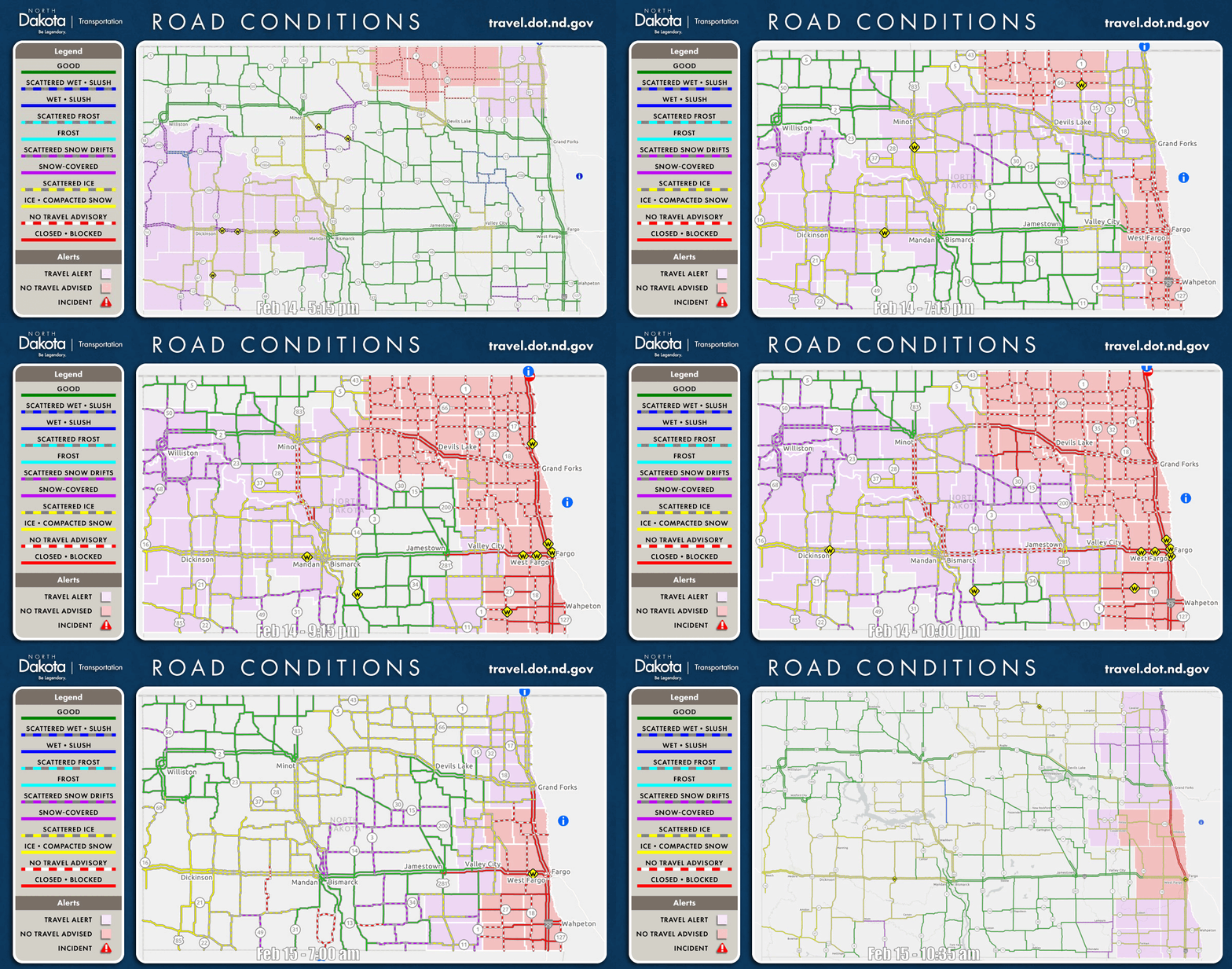
| North Dakota Road Conditions and Closures. Courtesy: North Dakota Department of Transportation. | Blizzard Storm Reports. |
Severe blizzard conditions led to impossible travel conditions for portions of the Devils Lake basin and southern Red River Valley starting the evening of February 14 lasting into the morning of February 15. This is in spite of the general lack of new snow (less than 6 inches) received from this event, as well as the overall lack of blowable snow around the region. Rather, the very strong winds exceeding 60 mph combined with just heavy enough snowfall to drive these severe blizzard conditions.
This event resulted in:
Wind
Public Information Statement
National Weather Service Grand Forks ND
521 AM CST Wed Feb 15 2023

...HIGHEST WIND REPORTS...

Listed are reports for 40 mph and higher wind gusts

Location                     Speed     Time/Date       Provider
Fargo AP ND                  66 MPH    1222 AM 02/15   ASOS
Grand Forks AP ND            66 MPH    0724 PM 02/14   ASOS
Halstad MN DOT               64 MPH    0915 PM 02/14   MESOWEST
Herman MN DOT                63 MPH    0350 AM 02/15   MESOWEST
East Grand Forks MN DOT      59 MPH    0320 AM 02/15   MESOWEST
Wahpeton AP ND               58 MPH    0415 AM 02/15   AWOS
Grafton AP ND                56 MPH    0935 PM 02/14   AWOS
Cooperstown AP ND            56 MPH    0115 AM 02/15   AWOS
Dilworth MN DOT              56 MPH    1210 AM 02/15   MESOWEST
Donaldson MN DOT             56 MPH    0805 PM 02/14   MESOWEST
Beltrami MN DOT              56 MPH    0230 AM 02/15   MESOWEST
Kent MN DOT                  56 MPH    1245 AM 02/15   MESOWEST
Eldred MN NDAWN              55 MPH    0935 PM 02/14   NDAWN
Prosper ND NDAWN             55 MPH    1120 PM 02/14   NDAWN
Valley City AP ND            55 MPH    0955 PM 02/14   AWOS
Crookston AP MN              55 MPH    1135 PM 02/14   AWOS
Grand Forks ND AFB           55 MPH    0526 PM 02/14   ASOS
Warren MN NDAWN              54 MPH    1145 PM 02/14   NDAWN
Fergus Falls AP  MN          54 MPH    1135 PM 02/14   AWOS
Sabin MN NDAWN               53 MPH    0945 PM 02/14   NDAWN
Hampden ND 3 SE              53 MPH    0858 PM 02/14   RAWS
Cando AP ND                  53 MPH    0955 PM 02/14   AWOS
Moorhead AP MN               53 MPH    1055 PM 02/14   AWOS
Mooreton ND NDAWN            52 MPH    0945 PM 02/14   NDAWN
Gwinner AP ND                52 MPH    0115 AM 02/15   AWOS
McHenry ND NDAWN             51 MPH    0845 PM 02/14   NDAWN
Langdon AP ND                51 MPH    0955 PM 02/14   AWOS
Fergus Falls MN DOT          51 MPH    0505 AM 02/15   MESOWEST
Ada MN NDAWN                 50 MPH    0945 PM 02/14   NDAWN
Dazey ND NDAWN               50 MPH    1220 AM 02/15   NDAWN
Galesburg ND NDAWN           50 MPH    0755 PM 02/14   NDAWN
Campbell MN NDAWN            49 MPH    1145 PM 02/14   NDAWN
Inkster ND NDAWN             49 MPH    0655 PM 02/14   NDAWN
Wahpeton ND NDAWN            49 MPH    0210 AM 02/15   NDAWN
East Grand Forks MN 4 N      49 MPH    0900 PM 02/14   DAVIS
Cavalier AP ND               49 MPH    0815 PM 02/14   AWOS
Devils Lake AP ND            49 MPH    0908 PM 02/14   AWOS
Moorhead MN DOT              49 MPH    0130 AM 02/15   MESOWEST
Hillsboro ND NDAWN           48 MPH    1120 PM 02/14   NDAWN
Kempton ND NDAWN             48 MPH    0755 PM 02/14   NDAWN
St Thomas ND NDAWN           48 MPH    1000 PM 02/14   NDAWN
East Grand Forks MN 5 ENE    48 MPH    1055 PM 02/14   DAVIS
Rothsay MN DOT               48 MPH    0200 AM 02/15   MESOWEST
Mahnomen MN DOT              48 MPH    1100 PM 02/14   MESOWEST
St Vincent MN DOT            48 MPH    0650 PM 02/14   MESOWEST
Kennedy MN NDAWN             47 MPH    1040 PM 02/14   NDAWN
Hope ND NDAWN                47 MPH    0935 PM 02/14   NDAWN
Cooperstown ND NDAWN         47 MPH    0210 AM 02/15   NDAWN
Edmore ND NDAWN              47 MPH    0830 PM 02/14   NDAWN
Grand Forks ND NDAWN         47 MPH    0210 AM 02/15   NDAWN
Logan Center ND NDAWN        47 MPH    0845 PM 02/14   NDAWN
Mayville ND NDAWN            47 MPH    1120 PM 02/14   NDAWN
Walhalla AP ND               47 MPH    0755 PM 02/14   AWOS
Hallock AP MN                47 MPH    0915 PM 02/14   AWOS
Adams ND NDAWN               46 MPH    1040 PM 02/14   NDAWN
Pekin ND NDAWN               46 MPH    0530 PM 02/14   NDAWN
Webster ND NDAWN             46 MPH    0750 PM 02/14   NDAWN
Tenney MN DOT                46 MPH    0925 PM 02/14   MESOWEST
Perley MN NDAWN              45 MPH    1120 PM 02/14   NDAWN
Stephen MN NDAWN             45 MPH    1040 PM 02/14   NDAWN
Crary ND NDAWN               45 MPH    1000 PM 02/14   NDAWN
Fargo ND NDAWN               45 MPH    1055 PM 02/14   NDAWN
Brampton ND NDAWN            45 MPH    1040 PM 02/14   NDAWN
Lisbon ND NDAWN              45 MPH    1000 PM 02/14   NDAWN
Park Rapids AP MN            45 MPH    0239 AM 02/15   ASOS
Cando ND NDAWN               44 MPH    1055 PM 02/14   NDAWN
Leonard ND NDAWN             44 MPH    0745 PM 02/14   NDAWN
Pillsbury ND NDAWN           44 MPH    0310 AM 02/15   NDAWN
Fosston AP MN                44 MPH    1255 AM 02/15   AWOS
Elbow Lake AP MN             44 MPH    0455 AM 02/15   AWOS
Michigan ND  NDAWN           43 MPH    0945 PM 02/14   NDAWN
Niles ND NDAWN               43 MPH    0620 PM 02/14   NDAWN
Finley ND NDAWN              43 MPH    1000 PM 02/14   NDAWN
Crary ND 15 N                43 MPH    0755 PM 02/14   DAVIS
Brooks MN DOT                43 MPH    1210 AM 02/15   MESOWEST
Frazee MN DOT                43 MPH    0125 AM 02/15   MESOWEST
Osage MN DOT                 43 MPH    0410 AM 02/15   MESOWEST
Baker ND NDAWN               42 MPH    0845 PM 02/14   NDAWN
Cavalier ND NDAWN            42 MPH    0845 PM 02/14   NDAWN
Fingal ND NDAWN              42 MPH    0210 AM 02/15   NDAWN
Lake Park MN DOT             42 MPH    0455 AM 02/15   MESOWEST
Forest River ND NDAWN        41 MPH    0745 PM 02/14   NDAWN
Maddock ND NDAWN             41 MPH    0830 PM 02/14   NDAWN
Grand Forks ND 7 SW          41 MPH    1015 PM 02/14   CWOP
Karlstad MN 1 NE             41 MPH    1206 AM 02/15   RAWS
Thief River Falls AP MN      41 MPH    0338 AM 02/15   AWOS
Mahnomen AP MN               40 MPH    1055 PM 02/14   AWOS
Gatzke MN DOT                40 MPH    1145 PM 02/14   MESOWEST
Thief River Falls MN DOT     40 MPH    0420 AM 02/15   MESOWEST
Goodridge MN DOT             40 MPH    0100 AM 02/15   MESOWEST

Observations are collected from a variety of sources with varying
equipment and exposures. We thank all volunteer weather observers
for their dedication. Not all data listed are considered official.

$$
Photos & Video
WC MN - I94 (W/B)5 miles east of Moorhead. Working with MNDOT & tow trucks to remove vehicles and clear the roads. Some of these vehicles have been here since after 8pm last night. Now 2/15/23 8am roads are still closed. https://t.co/UtVIO3l2qZ (many more than what is in video) pic.twitter.com/O1XLX1ewty
— Sgt. Jesse Grabow (@MSPPIO_NW) February 15, 2023
Environment
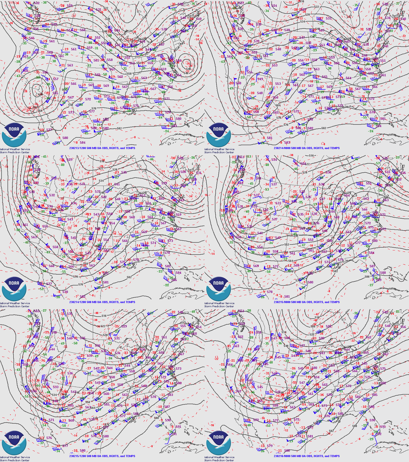
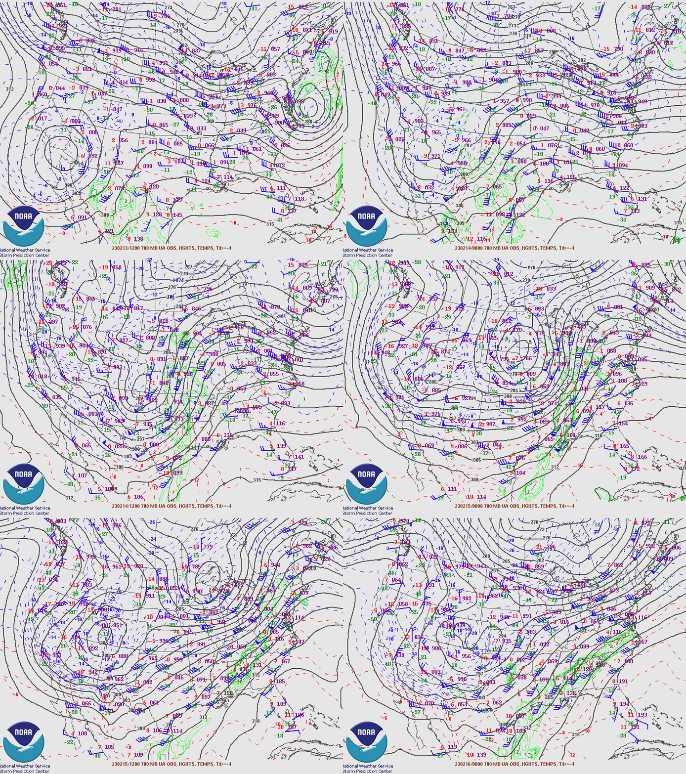
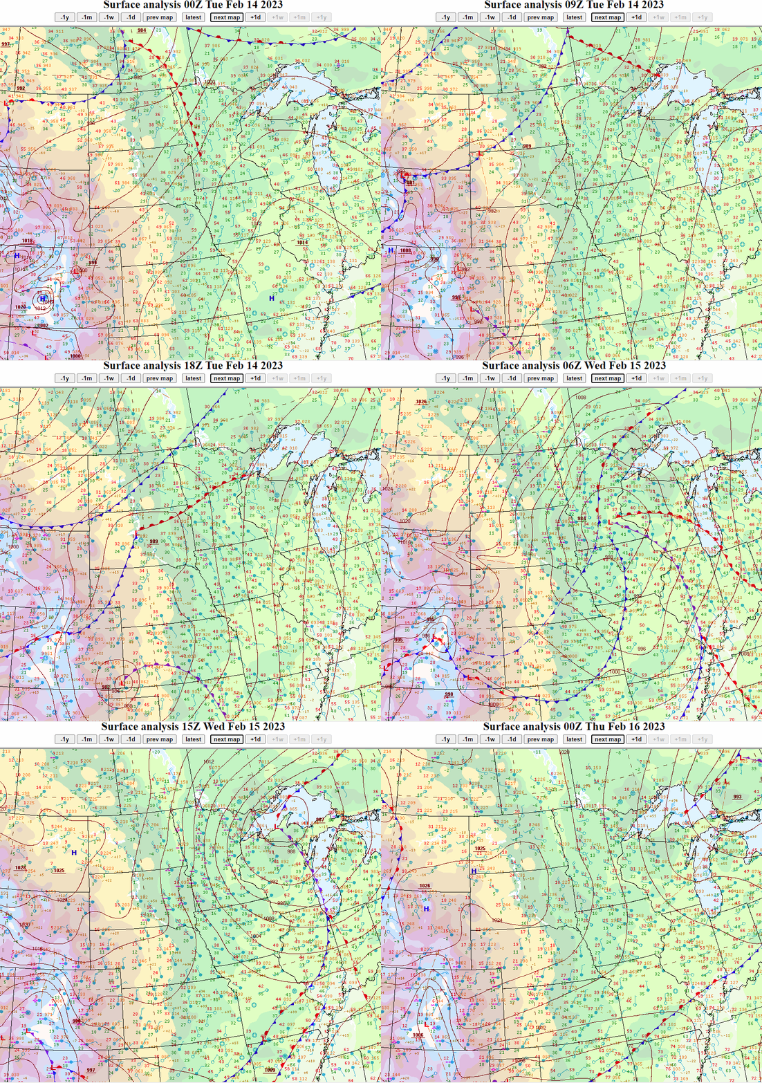
An upper low moving out of the southwest CONUS merged with an upper trough over the Northern Plains and Upper Midwest. As these upper systems interacted and merged, a surface low rapidly deepened to an unseasonably strong magnitude as it entered Minnesota. The strong pressure gradient combined with strong cold air advection rush down the back side of the low from Canada resulted in over 60 mph wind gusts within the Red River Valley, with widespread sustained winds over 35 mph across the region, as well as rapidly falling temperatures from the 20s and 30s to single digits either side of zero in less than 12 hours. As this system developed and winds increased, small snow bands developed on the northern and western flanks of the surface low. The combination of very strong winds and sufficiently heavy snow rates produced blizzard conditions within portions of the Red River Valley and Devils Lake Basin during the afternoon and overnight hours of February 14. As snow pulled away to the east the morning of February 15, blizzard conditions ceased despite gusty winds lingering.
 |
 |
 |
| Upper Air Analysis - 500 mb | Upper Air Analysis - 700 mb | Surface Analysis - WPC |
 |
Media use of NWS Web News Stories is encouraged! Please acknowledge the NWS as the source of any news information accessed from this site. |
 |