Overview
Blowing snow plumes stretched down from Canada into portions of the Red River Valley, causing blizzard conditions underneath these plumes. Outside of the plumes, blowing snow still reduced visibility. In addition, dangerous wind chills coincided with the blowing snow, making travel hazardous.Wind
Public Information Statement
National Weather Service Grand Forks ND
813 PM CST Fri Dec 23 2022

...HIGHEST WIND REPORTS TODAY ACROSS EASTERN ND AND NORTHWEST MN...

Location                     Speed     Time/Date       Provider
Herman MN DOT                52 MPH    0105 PM 12/23   MESOWEST
Fergus Falls MN DOT          49 MPH    1100 AM 12/23   MESOWEST
East Grand Forks MN DOT      48 MPH    1215 PM 12/23   MESOWEST
Wahpeton AP ND               46 MPH    1215 PM 12/23   AWOS
Frazee MN DOT                46 MPH    0220 PM 12/23   MESOWEST
Lake Park MN DOT             46 MPH    1040 AM 12/23   MESOWEST
Cando AP ND                  45 MPH    0955 AM 12/23   AWOS
Donaldson MN DOT             45 MPH    0935 AM 12/23   MESOWEST
Elbow Lake AP MN             45 MPH    1155 AM 12/23   AWOS
Grafton AP ND                44 MPH    1215 PM 12/23   AWOS
St Vincent MN DOT            44 MPH    0725 AM 12/23   MESOWEST
Beltrami MN DOT              43 MPH    1115 AM 12/23   MESOWEST
Crookston AP MN              43 MPH    0115 PM 12/23   AWOS
Fergus Falls AP  MN          43 MPH    1035 AM 12/23   AWOS
Lancaster MN DOT             43 MPH    0240 AM 12/23   MESOWEST
Grand Forks I-29 MP 145      42 MPH    0943 AM 12/23   NDDOT
Tenney MN DOT                42 MPH    0105 PM 12/23   MESOWEST
Humboldt MN NDAWN            42 MPH    0645 AM 12/23   NDAWN
Osage MN DOT                 42 MPH    1225 PM 12/23   MESOWEST
Cavalier AP ND               41 MPH    0535 AM 12/23   AWOS
Rothsay MN DOT               41 MPH    0230 PM 12/23   MESOWEST
Warren MN NDAWN              41 MPH    1245 PM 12/23   NDAWN
Thief River Falls AP MN      41 MPH    0702 AM 12/23   AWOS
Halstad MN DOT               41 MPH    1140 AM 12/23   MESOWEST
Park Rapids AP MN            41 MPH    1132 AM 12/23   ASOS
Kent MN DOT                  40 MPH    0115 PM 12/23   MESOWEST
Parkers Prairie MN NDAWN     40 MPH    1235 PM 12/23   NDAWN
Gatzke MN DOT                40 MPH    1100 AM 12/23   MESOWEST
Kennedy MN NDAWN             40 MPH    0545 AM 12/23   NDAWN
Cooperstown AP ND            39 MPH    1215 PM 12/23   AWOS
Grand Forks AP ND            39 MPH    0256 PM 12/23   ASOS
Fargo AP ND                  39 MPH    1119 AM 12/23   ASOS
Fingal ND NDAWN              39 MPH    0210 PM 12/23   NDAWN
Pillsbury ND NDAWN           39 MPH    0230 PM 12/23   NDAWN
Verndale MN DOT              39 MPH    1220 PM 12/23   MESOWEST
Flag Island MN               39 MPH    1235 PM 12/23   AWOS
Gwinner AP ND                38 MPH    0135 PM 12/23   AWOS
Wahpeton ND NDAWN            38 MPH    1035 AM 12/23   NDAWN
Campbell MN NDAWN            38 MPH    1055 AM 12/23   NDAWN
Eldred MN NDAWN              38 MPH    1240 PM 12/23   NDAWN
Ada MN NDAWN                 38 MPH    1245 PM 12/23   NDAWN
Mahnomen MN DOT              38 MPH    1230 PM 12/23   MESOWEST
Hallock AP MN                38 MPH    1235 PM 12/23   AWOS
Dilworth MN DOT              38 MPH    0125 PM 12/23   MESOWEST
Frazee MN 3 E                38 MPH    0105 PM 12/23   CWOP
Ulen MN NDAWN                38 MPH    0205 PM 12/23   NDAWN
Walhalla AP ND               37 MPH    1235 PM 12/23   AWOS
Grand Forks ND AFB           37 MPH    1100 AM 12/23   ASOS
Dazey ND NDAWN               37 MPH    1235 PM 12/23   NDAWN
East Grand Forks MN 5 ENE    37 MPH    1100 AM 12/23   DAVIS
Goodridge MN DOT             37 MPH    0930 AM 12/23   MESOWEST
Moorhead AP MN               37 MPH    1235 PM 12/23   AWOS
Moorhead MN DOT              37 MPH    0130 PM 12/23   MESOWEST
Hillsboro ND NDAWN           36 MPH    1230 PM 12/23   NDAWN
Finley ND NDAWN              36 MPH    0355 AM 12/23   NDAWN
Hampden ND 3 SE              36 MPH    0758 AM 12/23   RAWS
Cavalier ND NDAWN            36 MPH    1010 AM 12/23   NDAWN
Galesburg ND NDAWN           36 MPH    1035 AM 12/23   NDAWN
Leonard ND NDAWN             36 MPH    1240 PM 12/23   NDAWN
Crookston                    36 MPH    0900 AM 12/23   DAVIS
Waukon MN NDAWN              36 MPH    1245 PM 12/23   NDAWN
Thief River Falls MN DOT     36 MPH    0600 AM 12/23   MESOWEST
Holt MN 15 E                 36 MPH    0120 PM 12/23   RAWS
Mahnomen AP MN               36 MPH    1215 PM 12/23   AWOS
Williams MN NDAWN            36 MPH    0950 AM 12/23   NDAWN
Sabin MN NDAWN               36 MPH    1245 PM 12/23   NDAWN
Hope ND NDAWN                35 MPH    0205 PM 12/23   NDAWN
Bowesmont I-29 MP 196        35 MPH    0943 AM 12/23   NDDOT
St Thomas ND NDAWN           35 MPH    1235 PM 12/23   NDAWN
Langdon AP ND                35 MPH    0315 PM 12/23   AWOS
Brooks MN DOT                35 MPH    0715 AM 12/23   MESOWEST
Fosston AP MN                35 MPH    1055 AM 12/23   AWOS
East Grand Forks MN 4 N      35 MPH    1235 PM 12/23   DAVIS
Ottertail MN DOT             35 MPH    1100 AM 12/23   MESOWEST
Karlstad MN 1 NE             35 MPH    0706 AM 12/23   RAWS
Bemidji AP MN                35 MPH    1255 PM 12/23   AWOS

Observations are collected from a variety of sources with varying
equipment and exposures. We thank all volunteer weather observers
for their dedication. Not all data listed are considered official.

$$
Photos & Video
 |
 |
 |
 |
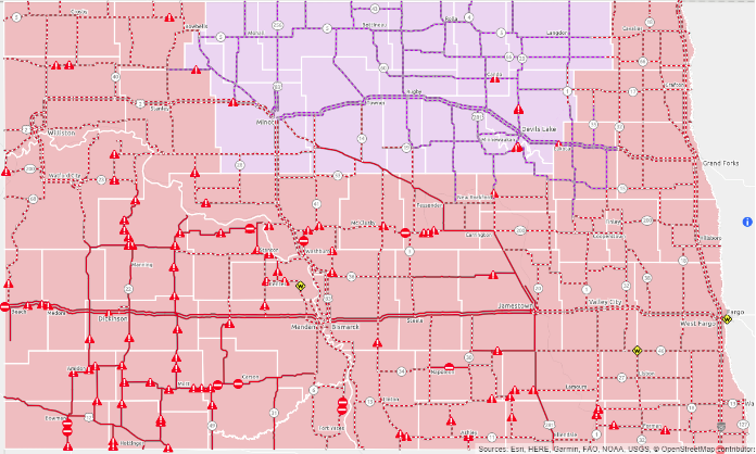
| Road Closures as of 8AM on the 23rd (NDDOT) |
Blizzard conditions outside of St. Hilaire (Grant Nelson via Facebook) |
Blizzard conditions outside of St. Hilaire (Grant Nelson via Facebook) |
Donaldson RWIS showing Blizzard Conditions (MNDOT) |
Storm Reports
Day Snow-Fog RGB images from @NOAASatellites #GOES16/#GOESeast revealed an impressive plume of horizontal convective rolls (accompanied by blowing snow) originating over southern Lake Manitoba & streaming SE across parts of #NDwx and #MNwx: https://t.co/fT4QK6vyLR pic.twitter.com/OiR6nZZs8n
— UW-Madison CIMSS (@UWCIMSS) December 23, 2022
Beautiful and painful views on the way home from work this morning. Surprisingly even in town had very poor vsby (~1/8-1/4 mi) at times. This along with icy roads and drifts truly made it difficult to get around. #ndwx #mnwx pic.twitter.com/CfBPb6avp7
— Carl Jones (@Wx_Jones) December 23, 2022
Blowing snow with 1 mile visibility at the Grand Forks International Airport #ndwx #nwsGrandForks #undaerospace pic.twitter.com/ttAqb7lRlg
— Fred Remer (@TopSeeder) December 23, 2022
The air hurts my face today.
— Cori (@coribregier) December 23, 2022
But the sky is pretty, so there’s that.@NWSGrandForks @LydiaBlumeWX #mnwx #WinterStorm #sota #winter #brrr pic.twitter.com/cYOnjH3G9b
âš ï¸BLIZZARD UPDATEâš ï¸Here's the latest in the 6 a.m. hour on this Friday morning. Wind gusts are increasing, and visibility is dropping. This is a ground blizzard event, meaning conditions may seem okay in town, but will worsen out in open country. #VNLFirstAlert #ndwx #mnwx #sdwx pic.twitter.com/2WaTPJhrdM
— Lisa Green (@LisaGreenVNL) December 23, 2022
Environment
 |
 |
 |
| Figure 1: Blowing Snow RGB for 14Z - 16Z | Figure 2: Blowing Snow RGB for 16Z - 19Z | Figure 3: Blowing Snow RGB for 19Z - 21Z |
 |
 |
 |
| Figure 4: 300mb | Figure 5: 500mb | Figure 6: 925mb |
 |
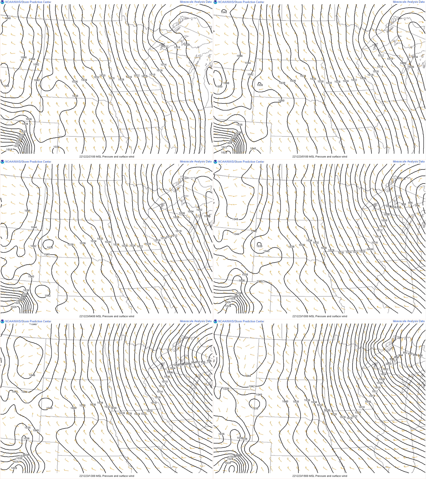
| Figure 7: MSLP and wind fields |
 |
Media use of NWS Web News Stories is encouraged! Please acknowledge the NWS as the source of any news information accessed from this site. |
 |