Overview
A large winter system stalled over the Northern Plains and Upper Midwest between December 13 - 17, 2022 creating a lengthy period of significant impacts from heavy snow between one to two feet, ice accumulation up to half an inch, as well as blowing and drifting snow.Snow/Ice
 |
| Snowfall between December 13 - 17, 2022. Courtesy NOHRSC. |
Public Information Statement
National Weather Service Grand Forks ND
118 PM CST Fri Dec 16 2022

...3-DAY SNOWFALL REPORTS...

Most reports include snowfall from early Tuesday (Dec 13) morning through
early Friday (Dec 16) morning.

The exceptions are
3 S Fargo                    11.6 in   1200 PM 12/16   CO-OP Observer
Grand Forks                  17.3 in   1200 PM 12/16   Official NWS Obs
which are from 6 am Tuesday through 12 pm Friday.


Location                     Amount    Time/Date       Provider

...Minnesota...

...Becker County...
5 NNW Cormorant              15.9 in   0700 AM 12/16   Cocorahs
3 WNW Two Inlets             15.7 in   0700 AM 12/16   Cocorahs
1 NNE Detroit Lakes          14.0 in   1100 AM 12/16   CO-OP Observer
3 ESE Westbury               11.5 in   0700 AM 12/16   Cocorahs

...Beltrami County...
4 E Lavinia                  11.8 in   0700 AM 12/16   Cocorahs

...Clay County...
3 N Muskoda                  17.1 in   0700 AM 12/16   Cocorahs
Moorhead                     15.3 in   0400 AM 12/16   Broadcast Media
Sabin                        12.2 in   0700 AM 12/16   CO-OP Observer
2 N Moorhead                 11.4 in   0700 AM 12/16   Cocorahs

...Kittson County...
Lancaster                    7.2 in    0700 AM 12/16   CO-OP Observer

...Norman County...
Twin Valley                  11.4 in   0700 AM 12/16   Cocorahs

...Otter Tail County...
Deer Creek                   15.2 in   0700 AM 12/16   Cocorahs
New York Mills               14.0 in   0730 AM 12/16   CO-OP Observer
5 ESE Elizabeth              12.1 in   0700 AM 12/16   Cocorahs
2 SE Ottertail               11.0 in   0700 AM 12/16   CO-OP Observer
3 SSE Battle Lake            9.0 in    0700 AM 12/16   Cocorahs

...Polk County...
5 N East Grand Forks         18.0 in   0700 AM 12/16   Cocorahs
3 ENE Maple Bay              15.0 in   0700 AM 12/16   Cocorahs
1 ENE Crookston              14.5 in   0700 AM 12/16   Cocorahs

...Roseau County...
Greenbush                    8.0 in    0700 AM 12/16   CO-OP Observer

...Wadena County...
1 NE Wadena                  13.2 in   0700 AM 12/16   Cocorahs
4 SE Blue Grass              13.0 in   0751 AM 12/16   Public
Sebeka                       8.6 in    0700 AM 12/16   CO-OP Observer

...Wilkin County...
3 SE Breckenridge            11.2 in   0700 AM 12/16   CO-OP Observer

...North Dakota...

...Barnes County...
Kathryn                      26.0 in   1200 AM 12/16   Public

...Cass County...
3 S Fargo                    11.6 in   1200 PM 12/16   CO-OP Observer
1 W Prairie Rose             11.3 in   0700 AM 12/16   Cocorahs

...Cavalier County...
1 ESE Langdon                10.1 in   0700 AM 12/16   Cocorahs

...Grand Forks County...
Larimore                     18.0 in   0700 AM 12/16   Cocorahs
Grand Forks                  17.3 in   1200 PM 12/16   Official NWS Obs

...Griggs County...
Cooperstown                  10.9 in   0700 AM 12/16   Cocorahs

...Nelson County...
Michigan                     18.5 in   0700 AM 12/16   CO-OP Observer

...Pembina County...
Pembina                      10.3 in   0700 AM 12/16   CO-OP Observer
2 NNW Backoo                 9.0 in    0700 AM 12/16   CO-OP Observer

...Ramsey County...
6 NW Devils Lake             22.0 in   0900 AM 12/16   Public

...Ransom County...
Lisbon                       28.4 in   0700 AM 12/16   CO-OP Observer
Enderlin                     26.0 in   0100 PM 12/16   Public

...Richland County...
3 E Mcleod                   20.7 in   0700 AM 12/16   CO-OP Observer

...Traill County...
7 ENE Grandin                14.8 in   0700 AM 12/16   Cocorahs
Mayville                     13.1 in   0700 AM 12/16   CO-OP Observer

...Walsh County...
4 W Pisek                    19.0 in   0700 AM 12/16   CO-OP Observer

Observations are collected from a variety of sources with varying
equipment and exposures. We thank all volunteer weather observers
for their dedication. Not all data listed are considered official.

$$
Impacts
Heavy snow, ice, as well as blowing and drifting snow between December 13 - 16 contributed to significant impacts across the region. This included several days of very hazardous travel conditions leading to numerous vehicle incidents with motorists injuries and rescues, lengthy road closures (including large portions of I-29 and I-94), "no travel advised" statements from the North Dakota Department of Transportation, as well as flight and train delays and cancellations. This caused numerous schools and businesses to close for multiple days. Ice and wind resulted in power outages and some tree damage. Lastly, heavy snow accumulation and large drifts impacted agriculture, namely to livestock.
 |
 |
 |
 |
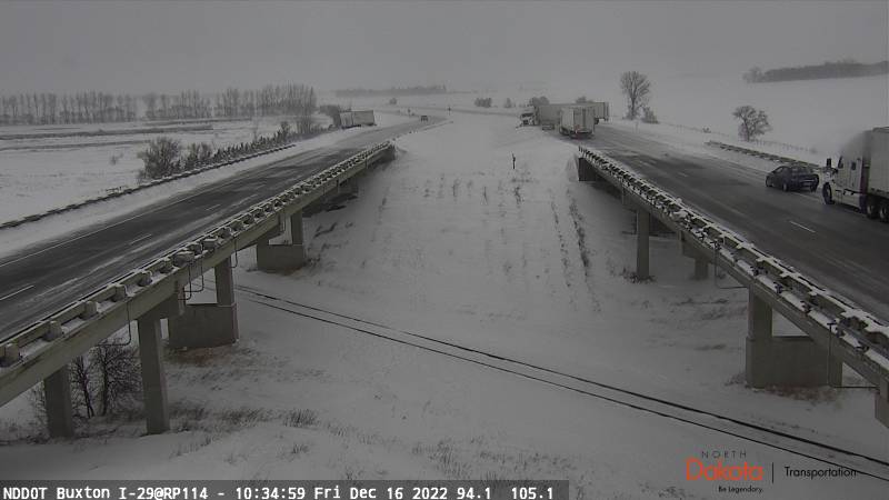
| North Dakota road conditions between December 12 - 17, 2022. Courtesy of NDDOT. | NWS Watch/Warning map throughout the event. For color legend, see here. Loop courtesy of ISU IEM. | This NDDOT webcam on I-29 near Buxton, ND, illustrated the very hazardous travel conditions on Dec 16, 2022, including a jackknifed semi, another semi in the ditch, icy roads, and reduced visibility. | In Calvin, ND, cattle caked with snow during this event gives a glimpse into the impact to livestock caught in the elements. Courtesy Greta Samuelson. |
Waking up to ICE this morning! Jen Ingraham says it was everywhere at the I-94 Oriska rest stop near Valley City, ND overnight! "Everything is coated in ice: parking lots, the road, the tree branches, and our radio antenna." #VNLFirstAlert #ndwx #sdwx #mnwx pic.twitter.com/2b2yaGGeqc
— Lisa Green (@LisaGreenVNL) December 13, 2022
WC MN - Troopers currently out w/12 crashes, spin outs & jackknifed semis in the region. (12/13/22 5:15pm) this vehicle ran off road in need of a tow truck I-94 about 5 miles east of Moorhead. Rain/snow mix becoming more snow now - roads obviously slush covered and slippery pic.twitter.com/j81ABEUtsV
— Sgt. Jesse Grabow (@MSPPIO_NW) December 13, 2022
NEAR-ZERO VISIBILITY taken around 4 PM on HWY 52 near Fessenden. Courtesy of Alex Larson. #ndwx pic.twitter.com/db6dulDsZX
— Amber Wheeler (@AmberWheelerWX) December 14, 2022
Crews have been out since the early hours clearing snow and assisting NDHP with stranded vehicles.
— NDDOT (@NorthDakotaDOT) December 15, 2022
High winds, additional snow accumulation and icy conditions will make it challenging. Always check the travel map before you head out. https://t.co/EXHjjzmsoB #ndwx #NDRoads pic.twitter.com/1LJoA0xidv
The troopers dash cam captured this semi crashing into the closure gate. The interstate from Jamestown to Fargo was closed at 2:00 pm. I-94 from Dickinson to Fargo and I-29 from Fargo to the SD border remain closed. The entire state of North Dakota is under a no travel advisory. pic.twitter.com/buauK4Jpsv
— North Dakota Highway Patrol (@NDHighwayPatrol) December 16, 2022
I went outside a bit ago to help my kid with her cats and calves. This weather is unreal. Stay safe everyone out working in this! #ndwx #blizzard pic.twitter.com/CK3wVB4UBf
— Jenny Schlecht (@jmreport) December 15, 2022
Parking in Dickinson is limited. Parking available at Biesiot Activities Center at DSU: 398 State Ave N, Dickinson, ND. #NDRoads #ndwx #I94 pic.twitter.com/xwPAZUOjPy
— NDDOT (@NorthDakotaDOT) December 15, 2022
Snow blowing the front walk to try and keep up with the heavy snowfall and drifting. As of 6pm CST, we measured 15.0" storm total thus far. A few more inches are likely before the night is over. Blizzard conditions will also continue through the night. #NDwx pic.twitter.com/KSYWQh2uIm
— NWS Bismarck (@NWSBismarck) December 16, 2022
I-29 between Fargo and Forks this morning, solid ice, do not recommend. #NDwx pic.twitter.com/lvYi89997T
— Jason Bednar (@JasonBednar1) December 16, 2022
Here is another way to show just how expansive impacts are from this system.
— NWS Grand Forks (@NWSGrandForks) December 16, 2022
Road conditions at 1:30 PM (where data is available) show numerous interstates and thoroughfares closed, along with a vast area of "no travel advised" within the Northern Plains. #ndwx #sdwx #newx https://t.co/6DxP3XcE3D pic.twitter.com/UUn93UCYq3
😧GOOD GOLLY!!! 7 Foot Drifts!! â—ï¸Blizzard Impacts!
— Hutch Johnson (@HutchVNL) December 16, 2022
Washington Elementary Valley City ND
By Aaron Heck#VNLFirstAlert #ndwx #mnwx #sdwx pic.twitter.com/7c2QinKlvR
Can confirm blizzard-like just outside of town near the Amtrak at 4pm. Roads are icy and VERY slick. @NWSGrandForks #ndwx #mnwx pic.twitter.com/IjjGrG9SdP
— Carl Jones (@Wx_Jones) December 16, 2022
There's a lot of snow to move and the wind is not cooperating. #NDHP #TrooperView near the Oriska underpass on I-94 taken this morning. pic.twitter.com/ueSMBXQcfG
— North Dakota Highway Patrol (@NDHighwayPatrol) December 16, 2022
#NDHP #TrooperView This crash on I-29 northbound near Hillsboro was just cleared, roads are still very icy. pic.twitter.com/Uzec6jytg2
— North Dakota Highway Patrol (@NDHighwayPatrol) December 16, 2022
Photos & Video
Numerous photos were submitted to NWS Grand Forks for this event. You can much more here.
 |
 |
 |
 |
| Significant drifting in Roseville, ND. Courtesy Rhonda Nelson. | Significant drifting in Devils Lake, ND. Courtesy Steve Hanlan. | Car buried in snow in Grand Forks, ND. Courtesy Shawn Greer. | Ruler in deep snow in south Fargo, ND. Courtesy Eugene Caldona. |
 |
 |
 |
 |
| Snow covered Christmas lights in Thief River Falls, MN. Courtesy Danica Robson. | Deep snow with Christmas lights in Grand Forks, ND. Courtesy Megan McIntyre. | Deep snow cover at Black Tiger Campground near Devils Lake, ND. Courtesy Black Tiger Campround. |
Deep snow cover west of Alexandria, MN. Courtesy Tamara Lund.
|
 |
 |
 |
 |
| Deep snow cover in Alvarado, MN. Courtesy Yuri Aza. | Deep snow cover in Ottertail, MN. Courtesy Brenda Johnson Strohschein. | Snow and horses in Fertile, MN. Courtesy Megan Marie. | Clearing snow off of a rooftop in Grand Forks, ND. Courtesy Heather Dove Mathre. |
 |
 |
 |
 |
| Heavy snow on Dec 15 2022 in Grand Forks, ND. Credit: Carl Jones | Heavy snow on Dec 15 2022 in Grand Forks, ND. Credit: Carl Jones | Icy roads on Dec 15 2022 in Grand Forks, ND. Credit: Carl Jones | Significant blowing snow in Grand Forks, ND, on Dec 15 2022. Credit: Carl Jones |
Radar / Satellite
Radar
 |
| The regional radar loop between December 13 - 17, 2022, shows several waves of precipitation moving over the Dakotas and Minnesota, most of which included heavy snow. |
Satellite
| Satellite loop between December 10 - 17, 2022, showing a large upper low stalling over the Northern Plains and Upper Midwest creating a long duration (3+ days) blizzard over portions of the Northern Plains. Also notice a second large, slow moving upper low downstream near New England, with an upper ridge in between the two lows. This type of pattern is conducive for slowing the forward propagation of weather systems, and is also known as as an omega block. This omega block was responsible for lingering blizzard conditions and heavy snow over portions of the Northern Plains and Upper Midwest for several days, creating long duration impacts lasting several days for some locations. This loop shows the Airmass RGB, useful for showing larger scale systems, clouds, and atmospheric moisture. Imagery courtesy of CSU CIRA (https://www.cira.colostate.edu/). |
Environment
 |
.gif) |
.com-gif-maker.gif) |
| Figure 1: 300mb | Figure 2: 500mb | Figure 3: 700mb |
.com-gif-maker%20(1).gif) |
.com-gif-maker.gif) |
 |
| Figure 4: 850mb Temp Advection | Figure 5: 925mb | Figure 6: Dendritic Layer Depth |
 |
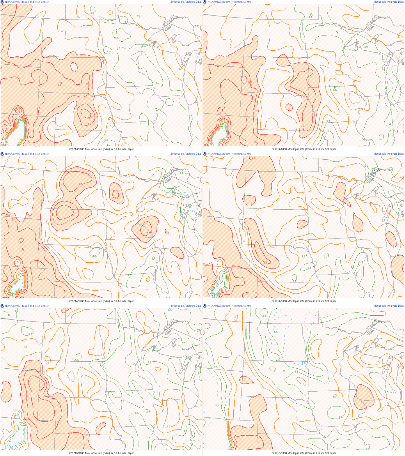
| Figure 7: Max Lapse Rates |
 |
Media use of NWS Web News Stories is encouraged! Please acknowledge the NWS as the source of any news information accessed from this site. |
 |