Overview
One supercell thunderstorm cluster tracked across much of the Devils Lake basin in
northeastern ND and produced at least one distinct tornado along its path, in addition
to areas of very heavy rain, large hail, and damaging downburst winds. Another
supercell thunderstorm cluster tracked across east central ND and into northwest MN
producing a persistent wall cloud feature, numerous funnel cloud and/or brief tornado
events, and areas of downburst wind, large hail, and very heavy rain all along its path.
Tornadoes:
|
Tornado #1 - near Starkweather, ND
Tornado #2 - east of Binford ND
Tornado #3 - north of Sharon, ND
Tornado #4 - west of Northwood, ND
Tornado #5 - near Davidson, MN
Tornado #6 - near Key West, MN
|
||||||||||||||||||||||||||||||||||||||||||||||||||||||||||||||||||||||||||||||||||||||||||||||||
The Enhanced Fujita (EF) Scale classifies tornadoes into the following categories:
| EF0 Weak 65-85 mph |
EF1 Moderate 86-110 mph |
EF2 Significant 111-135 mph |
EF3 Severe 136-165 mph |
EF4 Extreme 166-200 mph |
EF5 Catastrophic 200+ mph |
 |
|||||
Wind & Hail:
Wind
Although widespread wind damage did not occur across the region isolated locations did receive non-tornado wind damage.
Hail
The largest hail reported was 2.75 inches, or roughly the size of a baseball. The report of this large hail said the 'hail was larger than the diameter of a soda can'.
Here is the video of this large hail near Binford, ND - courtesy of Ken Carbary
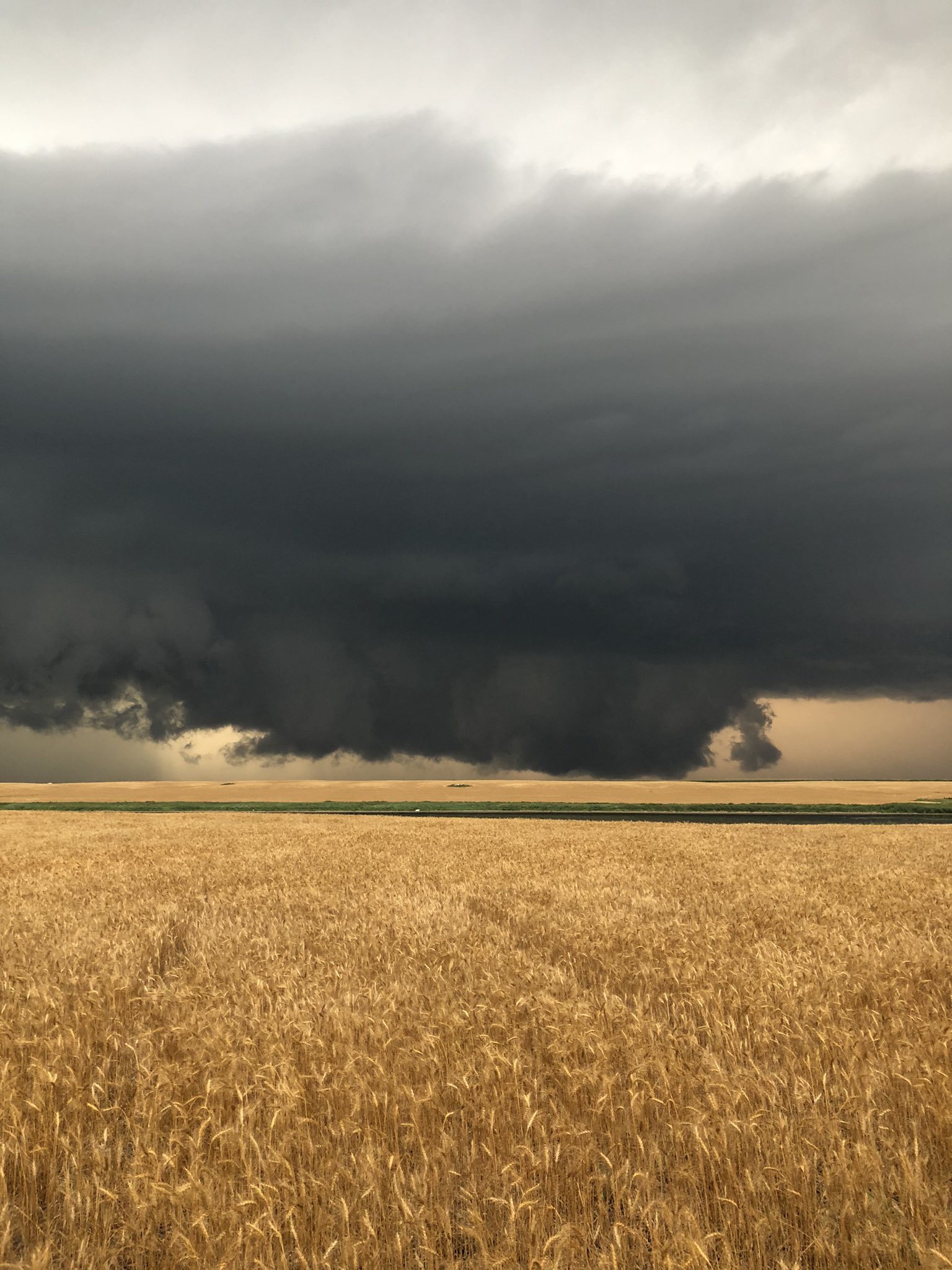
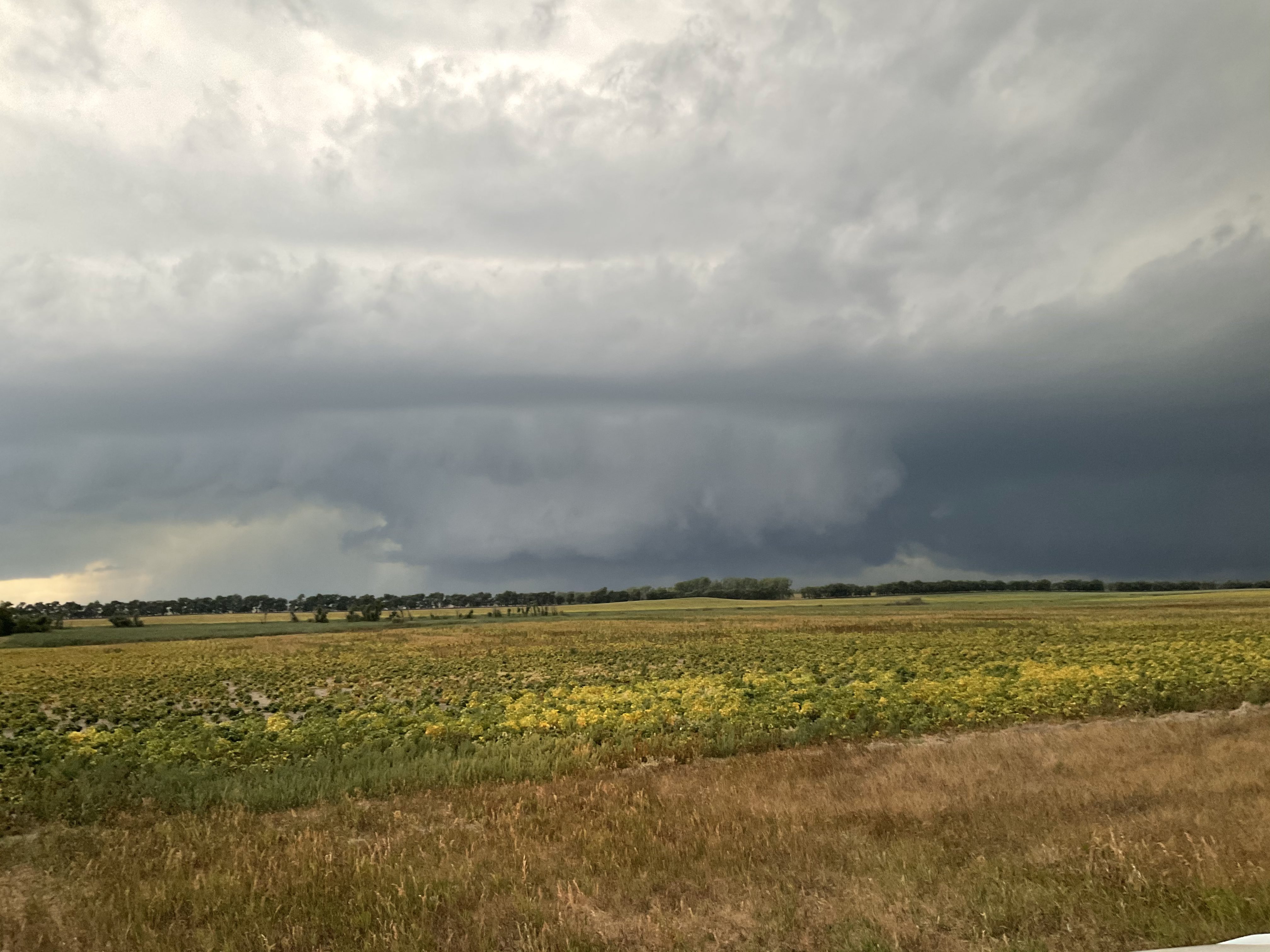
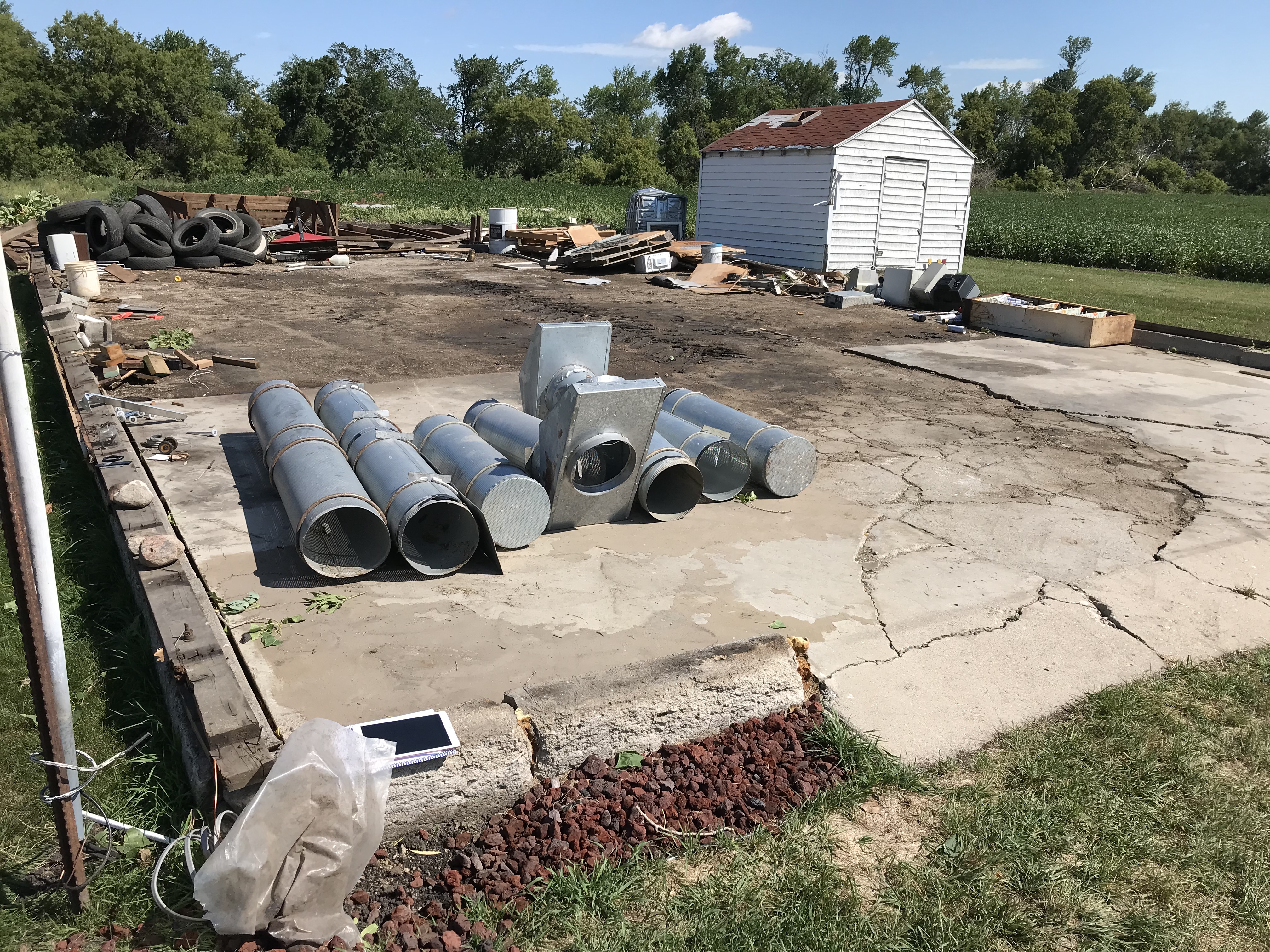
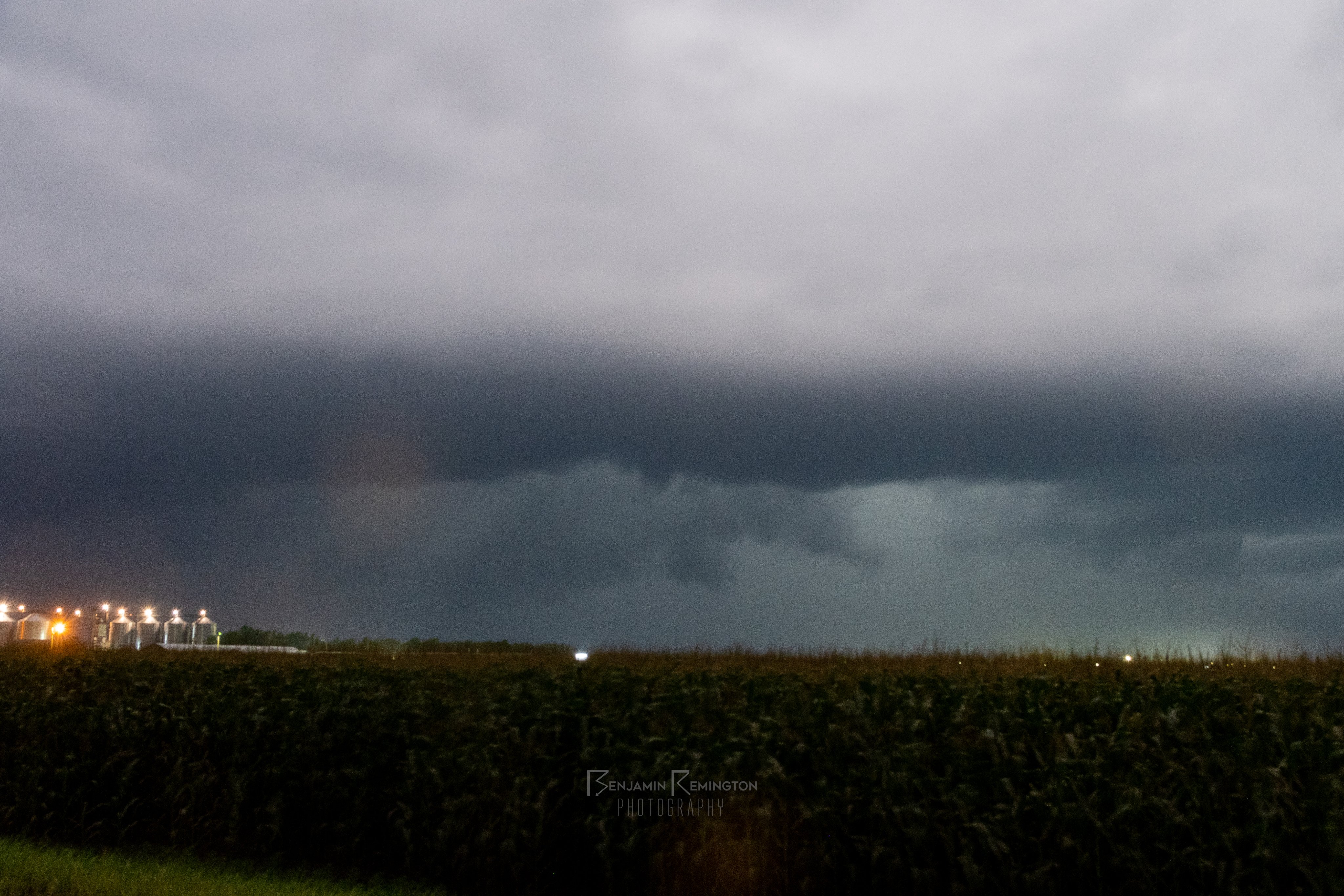
Photos & Video
 |
 |
 |
.jpg) |
| Wall cloud near McHenry, ND (Source: Justin Snead) |
Wall cloud 1 S Binford, ND (Source: Eric Whitehill) |
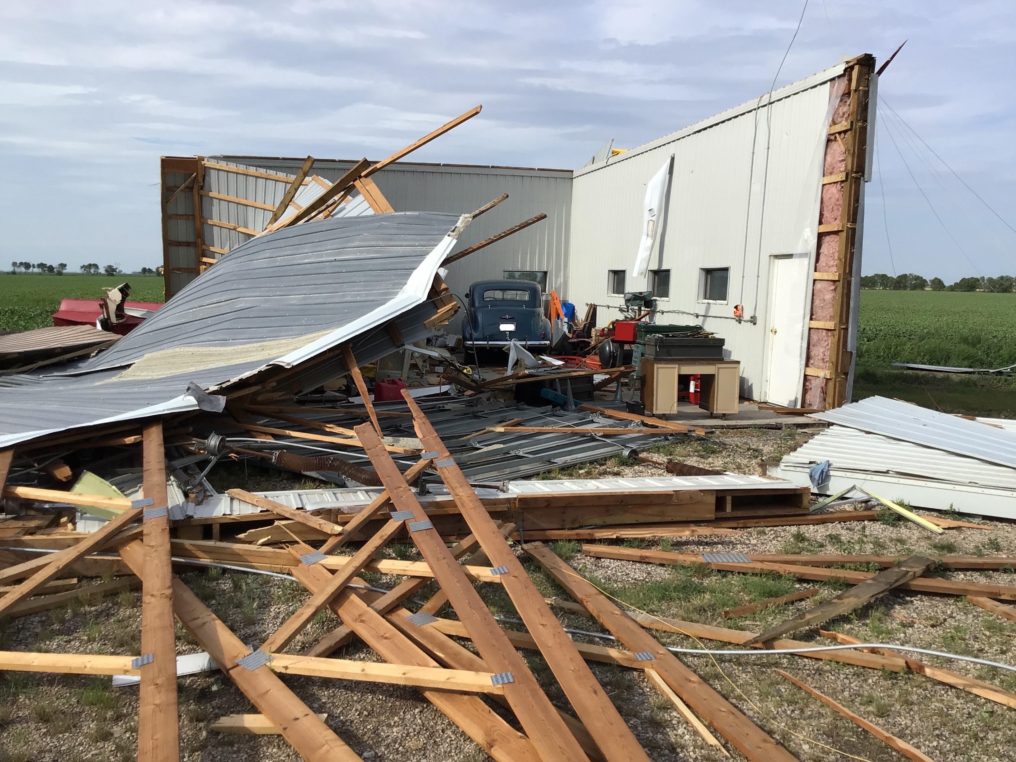
Destroyed barn 5 NNE Sharon, ND (Source: NWS) |
Hail near Langdon, ND (Source: Jason Hammer) |
 |
 |
 |
 |
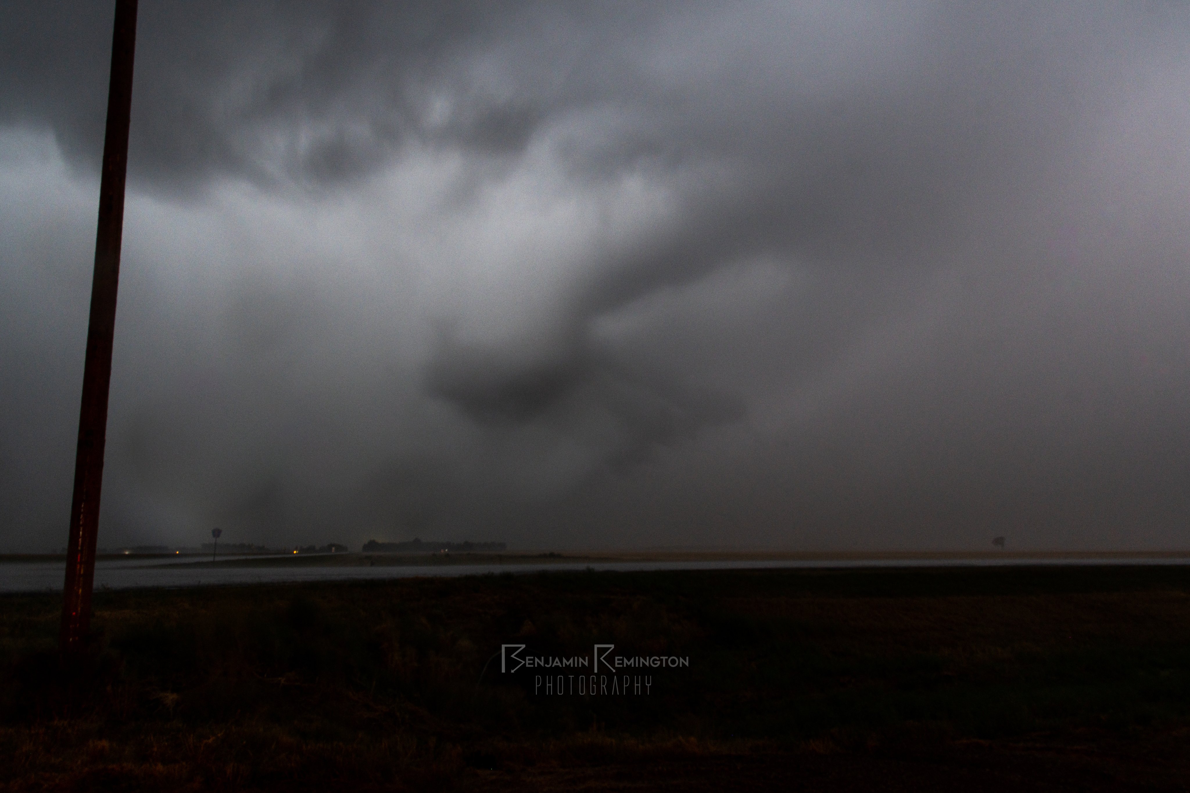
| Wall cloud near Northwood, ND (Source: Ben Remington) |
Funnel cloud southwest of Grand Forks, ND (Source: Ben Remington) |
Destroyed pole shed north of Fisher, MN (Source: NWS) |
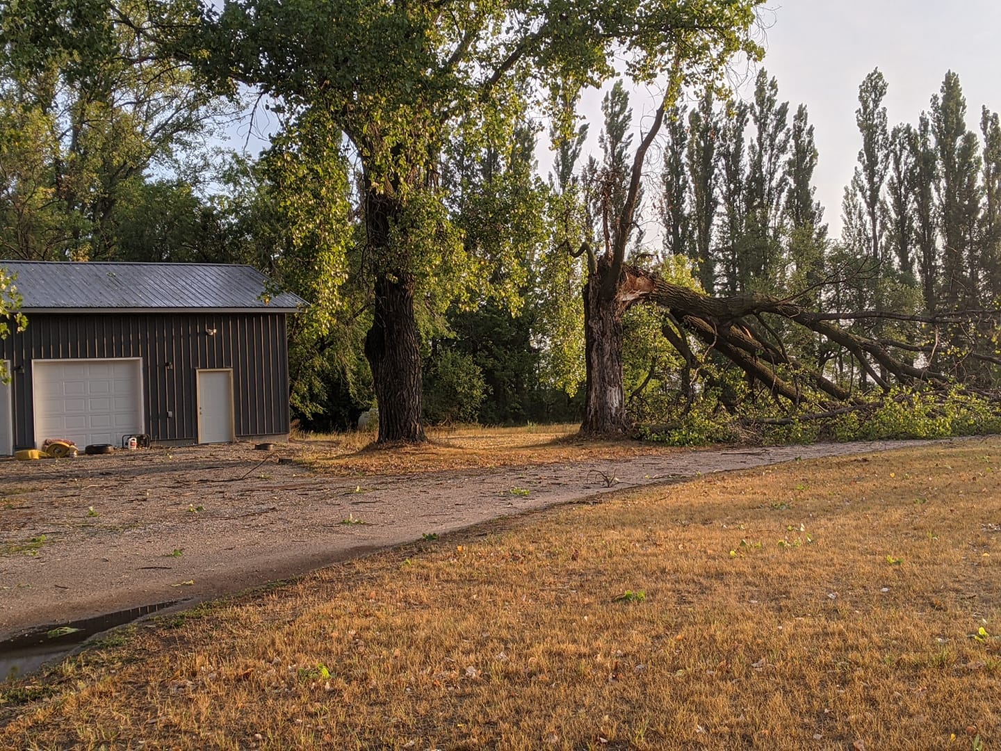
Downed tree 10 E Euclid, MN (Source: Jessica Brownsell) |
Radar
Loop of KMVX Radar Reflectivity and MRMS MESH tracks (August 9, 2021 4:56 pm CDT - August 10, 2021 3:46 am CDT)
Loop of GOES-West Visible Infrared Sandwich product (August 9, 2021 6:29 pm CDT - August 9, 2021 8:20 pm CDT)
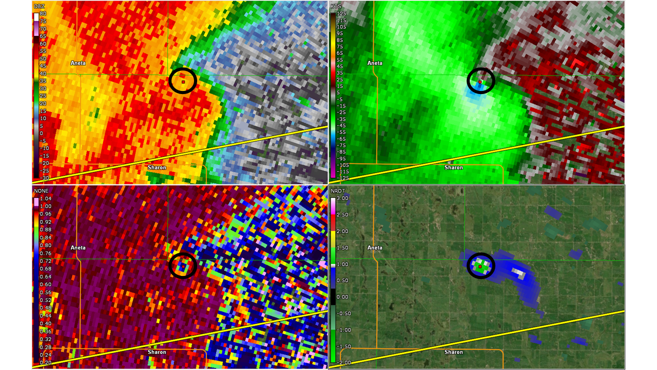
Clockwise from top left: KMVX 0.5 degree reflectivity, velocity, normalized rotation, and correlation coefficient denoting tornadic debris signature (TDS) ~6 NNE Sharon, ND.
Storm Reports

..TIME...   ...EVENT...      ...CITY LOCATION...     ...LAT.LON...
..DATE...   ....MAG....      ..COUNTY LOCATION..ST.. ...SOURCE....
            ..REMARKS..

0555 PM     HAIL             6 ESE ESMOND            48.00N 99.64W
08/09/2021  M1.00 INCH       Benson             ND   PUBLIC

            DIME TO QUARTER SIZED HAIL ACROSS NORTHERN HESPER
            TOWNSHIP. HAILED OFF AN ON FOR ABOUT 5 MINUTES.

0600 PM     HAIL             6 E ESMOND              48.03N 99.63W
08/09/2021  E0.50 INCH       Benson             ND   PUBLIC

            PEA TO MARBLE SIZED HAIL FOR 5 TO 10 MINUTES.

0621 PM     HAIL             4 SSW NEW ROCKFORD      47.63N 99.17W
08/09/2021  E1.50 INCH       Eddy               ND   PUBLIC

0625 PM     HAIL             8 W CANDO               48.49N 99.38W
08/09/2021  M1.00 INCH       Towner             ND   PUBLIC

            DIME TO QUARTER SIZED HAIL REPORTED ACROSS SOUTHEASTERN
            ZION TOWNSHIP. NEARLY COVERED THE GROUND.

0646 PM     TSTM WND DMG     3 WNW BRANTFORD         47.61N 98.98W
08/09/2021                   Eddy               ND   PUBLIC

            BROKEN WINDOWS FROM VERY STORNG WINDS AND HAIL AT LEAST
            QUARTER SIZED. TIME ESTIMATED FROM RADAR.

0650 PM     HAIL             BINFORD                 47.56N 98.35W
08/09/2021  M1.25 INCH       GRIGGS             ND   PUBLIC

            PHOTO AND REPORT POSTED VIA SOCIAL MEDIA.

0701 PM     HAIL             3 ENE BRANTFORD         47.61N 98.86W
08/09/2021  E1.75 INCH       Eddy               ND   TRAINED SPOTTER

0716 PM     TORNADO          5 W STARKWEATHER        48.45N 98.99W
08/09/2021  F1               Towner             ND   TRAINED SPOTTER

            A TORNADO TOUCHED DOWN IN NORTHEAST COOLIN TOWNSHIP AND
            TRACKED INTERMITTENTLY TO THE NORTHEAST FOR ROUGHLY 4
            MILES TO AROUND 4 NW STARKWEATHER IN WESTCENTRAL
            KLINGSTRUP TOWNSHIP /RAMSEY COUNTY/ BY 723 PM CDT. THE
            TORNADO SNAPPED OR UPROOTED SEVERAL LARGE COTTONWOOD
            TREES AT FARMSTEADS AND SHELTERBELTS ALONG ITS PATH. PEAK
            WINDS ESTIMATED FROM 80 TO 90 MPH. MAXIMUM WIDTH TO 200
            YARDS.

0727 PM     HAIL             2 S STARKWEATHER        48.42N 98.88W
08/09/2021  E1.25 INCH       Ramsey             ND   PUBLIC

            QUARTER TO HALF DOLLAR SIZED HAIL FOR A FEW MINUTES.

0730 PM     HAIL             6 S HAMAR               47.76N 98.57W
08/09/2021  E1.25 INCH       Eddy               ND   TRAINED SPOTTER

            VERY HEAVY RAINS ANDA FEW QUARTER TO HALF DOLLAR SIZED
            HAIL.

0745 PM     TSTM WND GST     1 SE HAMPDEN            48.53N 98.64W
08/09/2021  M50.00 MPH       Ramsey             ND   MESONET

            PEAK WIND MEASURED AT A RAWS STATION. TIME ESTIMATED
            BASED ON RADAR.

0800 PM     HAIL             2 E PEKIN               47.79N 98.28W
08/09/2021  E1.25 INCH       Nelson             ND   PUBLIC

            HAIL FROM SOUTH OF TOLNA THROUGH EAST OF PEKIN, RANGING
            FROM NICKLE TO HALF DOLLAR SIZED.

0810 PM     HAIL             4 NNE MCHENRY           47.63N 98.56W
08/09/2021  E1.50 INCH       Eddy               ND   PUBLIC

            VERY HEAVY RAIN AND A FEW LARGE HAIL.

0818 PM     HAIL             6 S LANGDON             48.68N 98.37W
08/09/2021  E1.00 INCH       Cavalier           ND   PUBLIC

            A FEW DIME TO QUARTER SIZED HAIL.

0822 PM     HAIL             3 SE LANGDON            48.73N 98.33W
08/09/2021  E1.50 INCH       Cavalier           ND   PUBLIC

            A FEW QUARTER TO PING PONG BALL SIZED HAIL IN VERY HEAVY
            RAIN AND STRONG WINDS.

0824 PM     TSTM WND DMG     4 N MCVILLE             47.82N 98.18W
08/09/2021                   Nelson             ND   PUBLIC

            SEVERAL LARGE 4-6 INCH TREE BRANCHES BROKEN DOWN AROUND A
            FARMSTEAD.

0826 PM     HAIL             RED WILLOW LAKE         47.65N 98.37W
08/09/2021  M1.75 INCH       GRIGGS             ND   PUBLIC

            GOLF BALL OR LARGER SIZED HAIL. PHOTOS AND REPORTS POSTED
            VIA SOCIAL MEDIA.

0827 PM     TSTM WND DMG     6 NNW BINFORD           47.64N 98.39W
08/09/2021                   Griggs             ND   PUBLIC

            A FEW LARGE TREE LIMB BROKEN DOWN NEAR RED WILLOW LAKE.

0828 PM     FUNNEL CLOUD     3 WSW BINFORD           47.54N 98.40W
08/09/2021                   Griggs             ND   LAW ENFORCEMENT

            LARGE WALL CLOUD MOVING TOWARD BINFORD WITH A POSSIBLE
            FUNNEL CLOUD.

0834 PM     TORNADO          3 E BINFORD             47.56N 98.28W
08/09/2021  F0               Griggs             ND   STORM CHASER

            A BRIEF TOUCHDOWN WAS NOTED AND RECORDED ON VIDEO BETWEEN
            834 AND 835 PM CDT. THE TOUCHDOWN OCCURRED OVER AN OPEN
            FIELD AS THE STORM BECAME QUICKLY RAIN WRAPPED AND
            ADDITIONAL BRIEF TOUCHDOWNS MAY HAVE OCCURRED LATER IN
            THE EAST-NORTHEASTWARD PATH. PEAK WINDS ESTIMATED TO 75
            MPH. MAXIMUM WIDTH TO 50 YARDS.

0835 PM     HAIL             7 N BINFORD             47.66N 98.35W
08/09/2021  M2.75 INCH       Griggs             ND   PUBLIC

            PHOTO AND REPORT POSTED VIA SOCIAL MEDIA. HAIL WAS LARGER
            THAN THE DIAMETER OF A SODA CAN. TIME ESTIMATED BASED ON
            RADAR.

0903 PM     HAIL             2 SSE WALHALLA          48.89N 97.90W
08/09/2021  E1.00 INCH       Pembina            ND   PUBLIC

0909 PM     FUNNEL CLOUD     4 WNW SHARON            47.62N 97.98W
08/09/2021                   Steele             ND   LAW ENFORCEMENT

            A WELL DEVELOPED WALL CLOUD AND FUNNEL WERE VIEWED
            PASSING OVER A FARMSTEAD, AND REPORTED TO THE STEELE
            COUNTY SHERIFFS OFFICE.

0920 PM     TORNADO          5 NNE SHARON            47.66N 97.86W
08/09/2021  F2               Steele             ND   NWS STORM SURVEY

            A TORNADO TRACKED EASTWARD FOR ROUGHLY 3 MILES FROM FAR
            NORTHEAST SHARON TOWNSHIP ACROSS FAR NORTHWESTERN
            WESTFIELD TOWNSHIP TO AROUND 7 NE SHARON BY 928 PM CDT. A
            TORNADO DEBRIS SIGNATURE WAS EVIDENT ON KMVX RADAR. THE
            TORNADO COMPLETELY DISMANTLED AND DESTROYED A BARN AT ONE
            FARMSTEAD. IT ALSO SNAPPED OR UPROOTED NUMEROUS SPRUCE,
            ASH, COTTONWOOD, AND WILLOW TREES AT VARIOUS LOCATIONS
            ALONG ITS PATH. PEAK WINDS ESTIMATED TO 115 MILES AN
            HOUR. MAXIMUM WIDTH ESTIMATED TO 300 YARDS.

0923 PM     TSTM WND DMG     7 NE ANETA              47.75N 97.88W
08/09/2021                   Nelson             ND   NWS STORM SURVEY

            SPRUCE TREES PARTIALLY UPROOTED IN A SHELTERBELT. TIME
            ESTIMATED BASED ON RADAR.

0928 PM     FUNNEL CLOUD     8 NE SHARON             47.68N 97.78W
08/09/2021                   Grand Forks        ND   TRAINED SPOTTER

            A WELL DEVELOPED WALL CLOUD WITH POSSIBLE FUNNEL WAS
            REPORTED BY A STORM CHASER/STORM SPOTTER.

0931 PM     TSTM WND GST     2 E LOGAN CENTER        47.80N 97.78W
08/09/2021  M67.00 MPH       Grand Forks        ND   MESONET

            PEAK WIND MEASURED AT AN NDAWN STATION AT 10 METERS.

0936 PM     TSTM WND DMG     4 NE LOGAN CENTER       47.84N 97.76W
08/09/2021                   Grand Forks        ND   PUBLIC

            12 INCH DIAMETER CORRONWOOD LIMB DOWN. PEAS SIZED HAIL
            ALSO REPORTED. RELAY VIA SOCIAL MEDIA. TIME ESTIMATED
            FROM RADAR.

0942 PM     TORNADO          5 WNW NORTHWOOD         47.76N 97.67W
08/09/2021  F1               Grand Forks        ND   NWS STORM SURVEY

            A FEW COTTONWOOD TREES WERE SNAPPED OR UPROOTED IN A
            SHELTERBELT BETWEEN ABOUT 942 AND 943 PM CDT. LIKELY A
            BRIEF TORNADO TOUCHDOWN BASED ON RADAR SIGNATURE. PEAK
            WINDS ESTIMATED TO 90 MPH. MAXIMUM WIDTH TO 150 YARDS.
            TIME ESTIMATED BASED ON RADAR.

0945 PM     TSTM WND DMG     2 WSW NORTHWOOD         47.72N 97.61W
08/09/2021                   Grand Forks        ND   NWS STORM SURVEY

            A POPLAR TREE WAS BLOWN DOWN ALONG WITH SEVERAL LARGE
            TREE BRANCHES AND LIMBS AT THE NORTHWOOD GOLF COURSE.
            LIKELY CAUSED BY REAR FLANK DOWNDRAFT FROM A SUPERCELL
            THUNDERSTORM. TIME ESTIMATED BASED ON RADAR.

0954 PM     TSTM WND GST     GOLDEN LAKE             47.58N 97.64W
08/09/2021  M54.00 MPH       STEELE             ND   MESONET

            PEAK WIND MEASURED ON A PERSONAL WEATHER STATION.

1009 PM     TSTM WND DMG     5 SSW EMERADO           47.85N 97.41W
08/09/2021                   Grand Forks        ND   NWS STORM SURVEY

            A COUPLE OF COTTONWOOD TREES BLOWN OVER. TIME ESTIMATED
            BASED ON RADAR.

1030 PM     HAIL             WNW GRAND FORKS         47.92N 97.07W
08/09/2021  E1.00 INCH       Grand Forks        ND   PUBLIC

            REPORT RELAYED VIA SOCIAL MEDIA.

1035 PM     FUNNEL CLOUD     5 N THOMPSON            47.85N 97.11W
08/09/2021                   Grand Forks        ND   TRAINED SPOTTER

            A WELL DEVELOPED WALL CLOUD WITH BRIEF FUNNEL EVIDENT.
            WALL CLOUD WAS RAIN WRAPPED.

1037 PM     TSTM WND GST     5 WNW GRAND FORKS       47.94N 97.17W
08/09/2021  M69.00 MPH       Grand Forks        ND   ASOS

            PEAK WIND MEASURED AT THE GRAND FORKS INTERNATIONAL
            AIRPORT /KGFK/.

1038 PM     TSTM WND GST     GRAND FORKS             47.92N 97.07W
08/09/2021  M60.00 MPH       Grand Forks        ND   PUBLIC

            PEAK WIND MEASURED BY UND CLIFFORD HALL ANEMOMETER.

1042 PM     TSTM WND DMG     1 S GRAND FORKS         47.90N 97.07W
08/09/2021                   Grand Forks        ND   TRAINED SPOTTER

            NUMEROUS LARGE BRANCHES AND LIMBS DOWN ALONG BELMONT,
            SOUTH OF 27TH.

1044 PM     TSTM WND GST     2 N EAST GRAND FORKS    47.96N 97.02W
08/09/2021  M60.00 MPH       Polk               MN   MESONET

            PEAK WIND MEASURED AT A PERSONAL WEATHER STATION.

1045 PM     TSTM WND DMG     2 WNW GRAND FORKS       47.93N 97.11W
08/09/2021                   Grand Forks        ND   NWS STORM SURVEY

            METAL ROOF TORN OFF OF A BUSINESS ALONG U.S. HIGHWAY 2.
            TIME ESTIMATED BASED ON RADAR AND NEARBY SENSOR
            OBSERVATIONS.

1048 PM     TSTM WND GST     4 NNW GRAND FORKS       47.97N 97.11W
08/09/2021  M62.00 MPH       Grand Forks        ND   MESONET

            PEAK WIND MEASURED AT AN NDDOT RWIS STATION.

1049 PM     TSTM WND DMG     4 N EAST GRAND FORKS    47.99N 97.02W
08/09/2021                   Polk               MN   PUBLIC

            STEEL PANELS TORN OFF A POLESHED. LARGE TREE BRANCHES
            DOWN AROUND THE ARAE. PHOTO AND REPORT POSTED VIA SOCIAL
            MEDIA. TIME ESTIMATED BASED ON RADAR AND NEARBY WIND
            SENSOR REPORTS.

1055 PM     TORNADO          1 S DAVIDSON            47.86N 96.85W
08/09/2021  F1               Polk               MN   NWS STORM SURVEY

            A TORNADO TRACKED FOR ABOUT 3 MILES TO AROUND 5 NNE OF
            FISHER BY 1101 PM CDT. THE TORNADO BLEW OUT TWO WALLS OF
            A POLESHED, BROKE DOWN SEVERAL ASH AND COTTONWOOD TREES,
            AND PEELED UP TIN SIDING ON OTHER FARM BUILDING IN A
            YARD. IT CARRIED DEBRIS TO THE EAST AND SOUTHEAST FOR UP
            TO 500 YARDS WHIL IT MAINLY TRACKED TO THE EAST. PEAK
            WINDS ESTIMATED TO 105 MPH. MAXIMUM WIDTH TO 200 YARDS.

1055 PM     TSTM WND GST     5 ENE EAST GRAND FORKS  47.96N 96.92W
08/09/2021  M56.00 MPH       Polk               MN   MESONET

            PEAK WIND MEASURED AT A PERSONAL WEATHER STATION.

1105 PM     TORNADO          4 SE KEY WEST           47.89N 96.73W
08/09/2021  F0               Polk               MN   NWS STORM SURVEY

            A TORNADO TRACKED INTERMITTENTLY TO THE EAST-NORTHEAST
            FOR ROUGHLY 2 MILES TO AROUND 5SE KEY WEST BY 1109 PM
            CDT. THE TORNADO SNAPPED THE TOPS OFF OF SEVERAL ASH AND
            COTTONWOOD TREES AT TWO FARMSTEADS ALONG ITS PATH AND
            CRACKED A POWER POLE. PEAK WINDS ESTIMATED TO 80 MPH.
            MAXIMUM WIDTH TO 150 YARDS.

1131 PM     TSTM WND DMG     3 NNE DOROTHY           47.97N 96.42W
08/09/2021                   Pennington         MN   PUBLIC

            SEVERAL LARGE TREES BLOWN DOWN, ALONG WITH NUMEROUS LARGE
            TREE BRANCHES AND LIMBS. REPORT AND PHOTOS POSTED VUA
            SOCIAL MEDIA. TIME ESTIMATED BASED ON RADAR.
Rain Reports
000
NOUS43 KFGF 101640
PNSFGF
MNZ001>009-013>017-022>024-027>032-040-NDZ006>008-014>016-024-026>030-038-
039-049-052>054-110440-

Public Information Statement
National Weather Service Grand Forks ND
1140 AM CDT Tue Aug 10 2021

...PRECIPITATION REPORTS...

Location                     Amount    Time/Date       Provider
Langdon                      3.50 in   1159 PM 08/09   Public
2 N Wales                    3.35 in   1130 PM 08/09   Public
Langdon ND 1 E               3.27 in   0800 AM 08/10   COOP
Euclid 6.2 NNE               2.95 in   0700 AM 08/10   COCORAHS
Thief River Falls MN 0.6 NW  2.50 in   0600 AM 08/10   COCORAHS
4 NE Logan Center            2.40 in   1100 PM 08/09   Public
5 ENE Dakota Junction        2.20 in   0602 AM 08/10   Public
Hampden ND 3 SE              2.15 in   1058 AM 08/10   RAWS
Thief River Falls            2.00 in   0554 AM 08/10   Public
5 SW Baudette                2.00 in   0604 AM 08/10   Public
Espelie                      2.00 in   0630 AM 08/10   Public
Baudette AP MN               1.93 in   1053 AM 08/10   ASOS
Aneta                        1.80 in   1100 PM 08/09   Public
Grand Forks AP ND            1.73 in   1053 AM 08/10   ASOS
Thief River Falls MN 2 W     1.72 in   1120 AM 08/10   AWS
4 N East Grand Forks         1.69 in   0700 AM 08/10   COCORAHS
Baudette MN 3 S              1.67 in   1106 AM 08/10   RAWS
Sharon ND 7.9 ENE            1.65 in   0700 AM 08/10   COCORAHS
Holt MN 15 E                 1.58 in   1020 AM 08/10   RAWS
Holt MN 6 E                  1.58 in   1030 AM 08/10   HADS
Walhalla ND 3.6 SSE          1.58 in   0600 AM 08/10   COCORAHS
AGASSIZ NRW GOODRIDGE 12 NNW 1.55 in   1100 AM 08/10   HADS
Cavalier ND 7.9 WNW          1.55 in   0745 AM 08/10   COCORAHS
Thief River Falls AP MN      1.51 in   1056 AM 08/10   AWOS
4 S Warren                   1.51 in   0637 AM 08/10   Public
Grand Forks ND AFB           1.50 in   0956 AM 08/10   ASOS
Cavalier ND 7 NW             1.48 in   0700 AM 08/10   COOP
Warren MN                    1.45 in   0800 AM 08/10   COOP
2 S Viking                   1.45 in   0543 AM 08/10   Public
3 NNE Hazel                  1.38 in   0551 AM 08/10   Public
Sheyenne ND 2.7 WSW          1.37 in   0800 AM 08/10   COCORAHS
Larimore ND 0.4 SE           1.36 in   0700 AM 08/10   COCORAHS
Thief River Falls MN         1.32 in   1030 AM 08/10   HADS
Rosewood                     1.20 in   0615 AM 08/10   Public
Webster ND                   1.13 in   1120 AM 08/10   AWS
Goodridge MN 7.4 SW          1.11 in   0620 AM 08/10   COCORAHS
Dakota Junction MN 1 WSW     1.09 in   1120 AM 08/10   AWS
2 N Holt                     1.05 in   0620 AM 08/10   Public
3 NW High Landing            1.00 in   0617 AM 08/10   Public
Grand Forks ND 3.4 SSE       0.96 in   0700 AM 08/10   COCORAHS
Grand Forks ND 2.5 SE        0.92 in   0600 AM 08/10   COCORAHS
Pembina ND                   0.90 in   0700 AM 08/10   COOP
Grand Forks 2.6 SE           0.87 in   0800 AM 08/10   COCORAHS
Clemenston MN                0.77 in   1100 AM 08/10   HADS
Oslo MN 2.7 WNW              0.75 in   0700 AM 08/10   COCORAHS
Warren MN 6.6 NW             0.72 in   0700 AM 08/10   COCORAHS
Red Lake Falls MN            0.70 in   1030 AM 08/10   HADS
Petersburg ND 2 N            0.62 in   0800 AM 08/10   COOP
Fort Totten ND 5 ENE         0.61 in   1051 AM 08/10   RAWS
Leeds ND 4 SE                0.52 in   1015 AM 08/10   HADS
Larimore ND 4.9 SSE          0.51 in   0700 AM 08/10   COCORAHS
Tolna ND 3 NW                0.50 in   1100 AM 08/10   HADS


Observations are collected from a variety of sources with varying
equipment and exposures. We thank all volunteer weather observers
for their dedication. Not all data listed are considered official.

$$
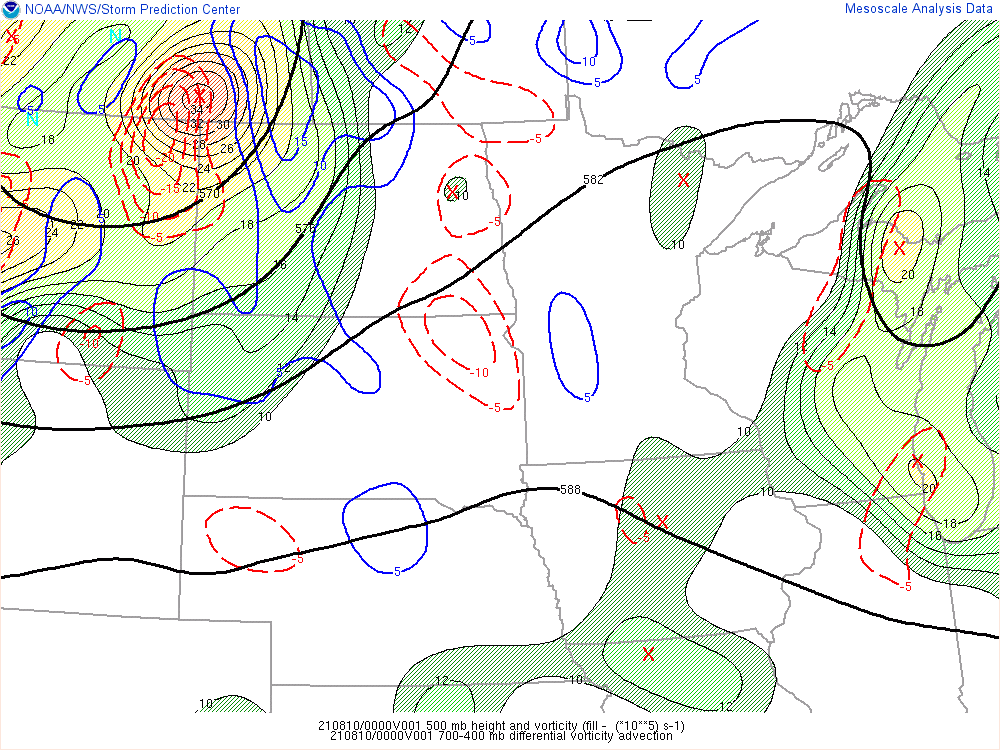
Environment
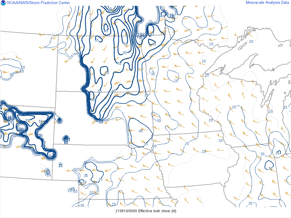
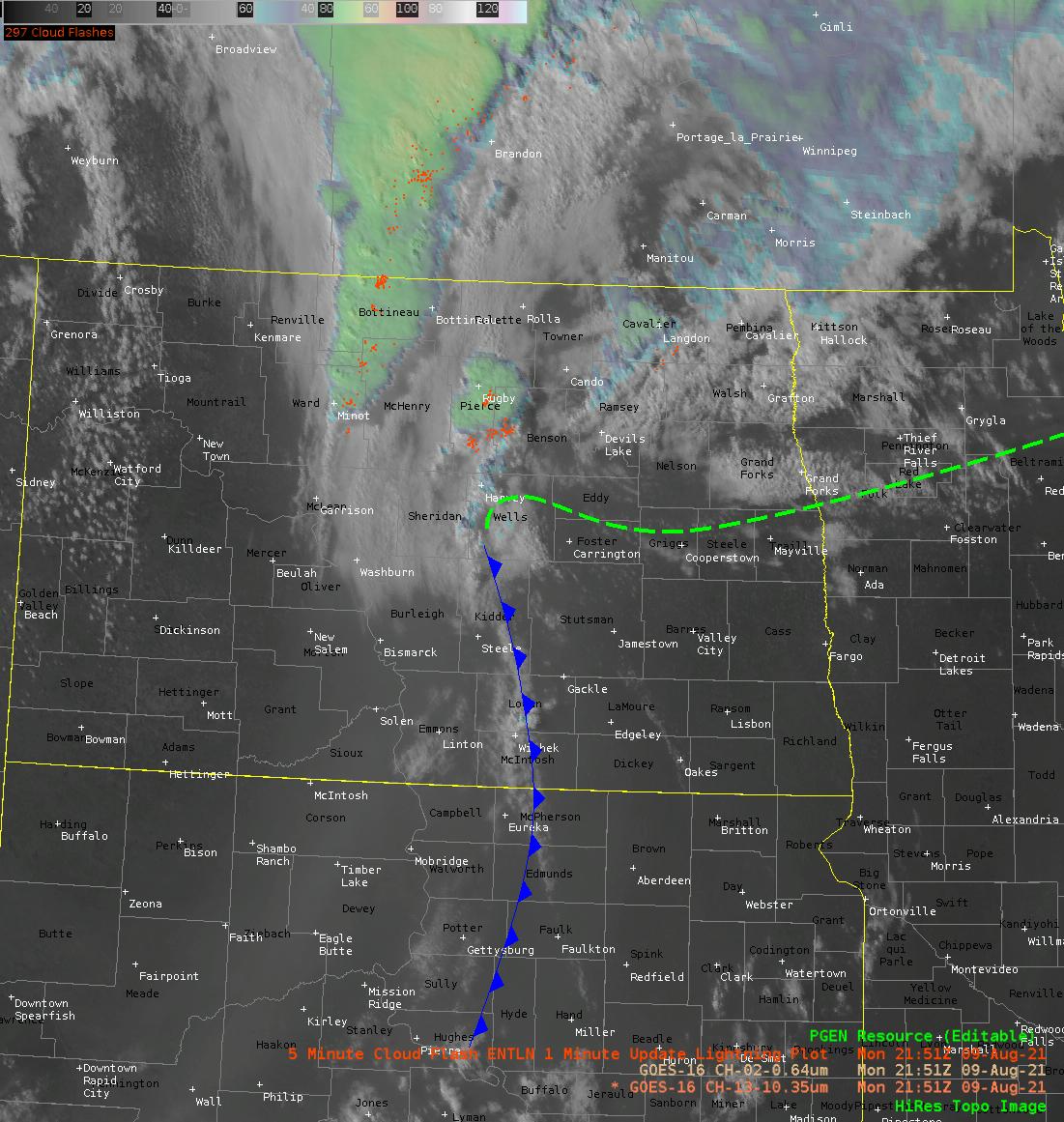 |
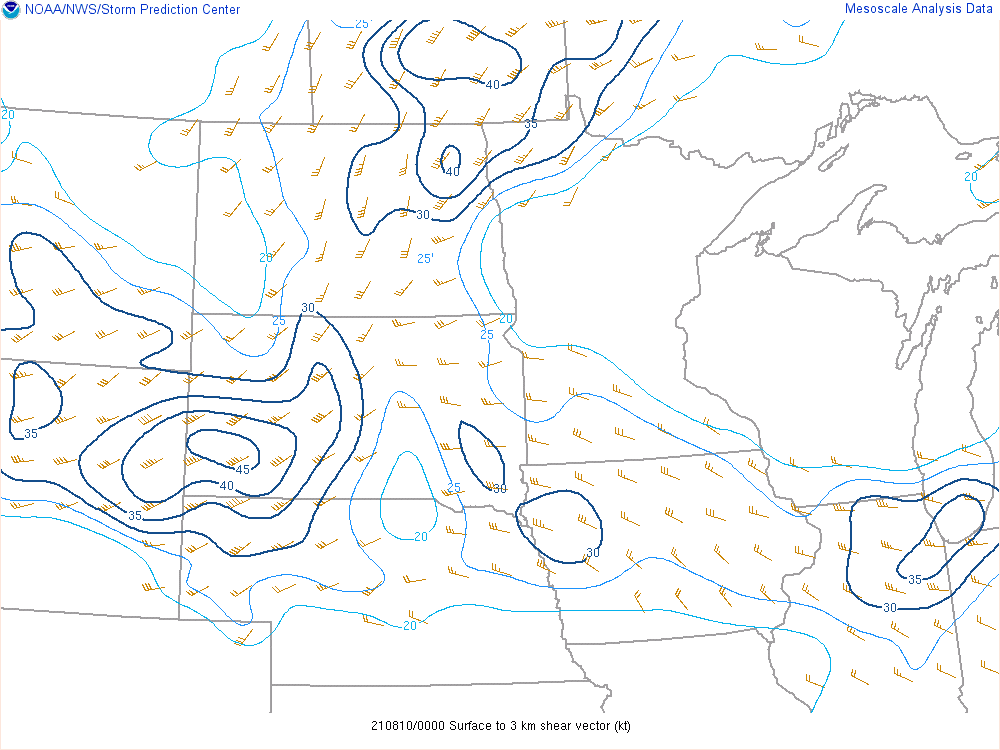 |
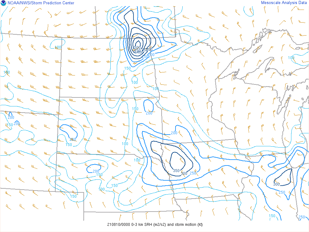 |
| Surface analysis with radar and satellite (2151z) |
0-3 km shear (00z) |
0-3 SRH (00z) |
 |
 |
 |
| Effective shear (00z) |
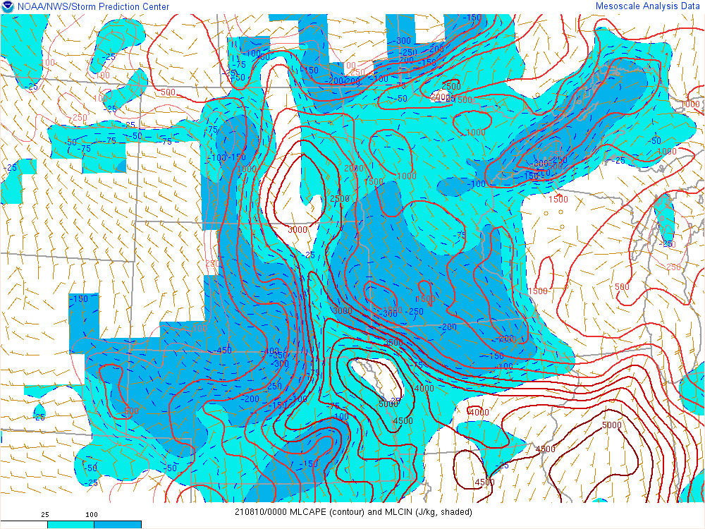
MLCAPE (00z) |
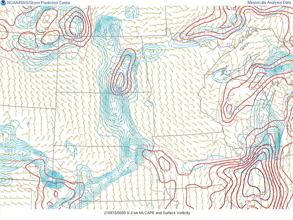
0-3 km MLCAPE and surface vorticity |
 |
 |
 |
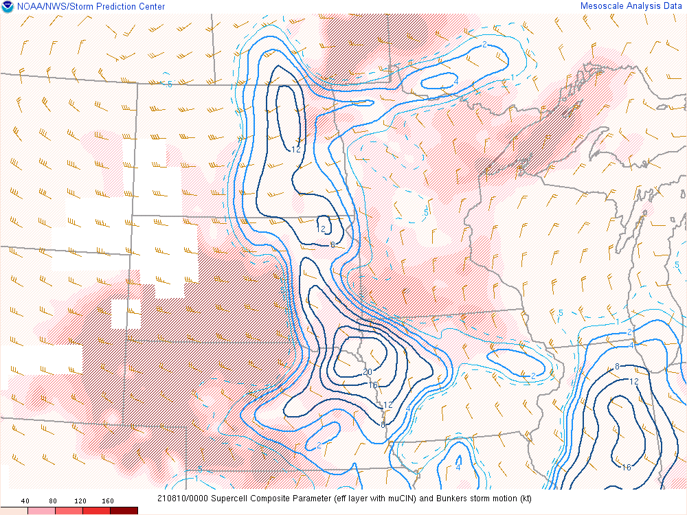
| Supercell Composite Parameter (00z) |
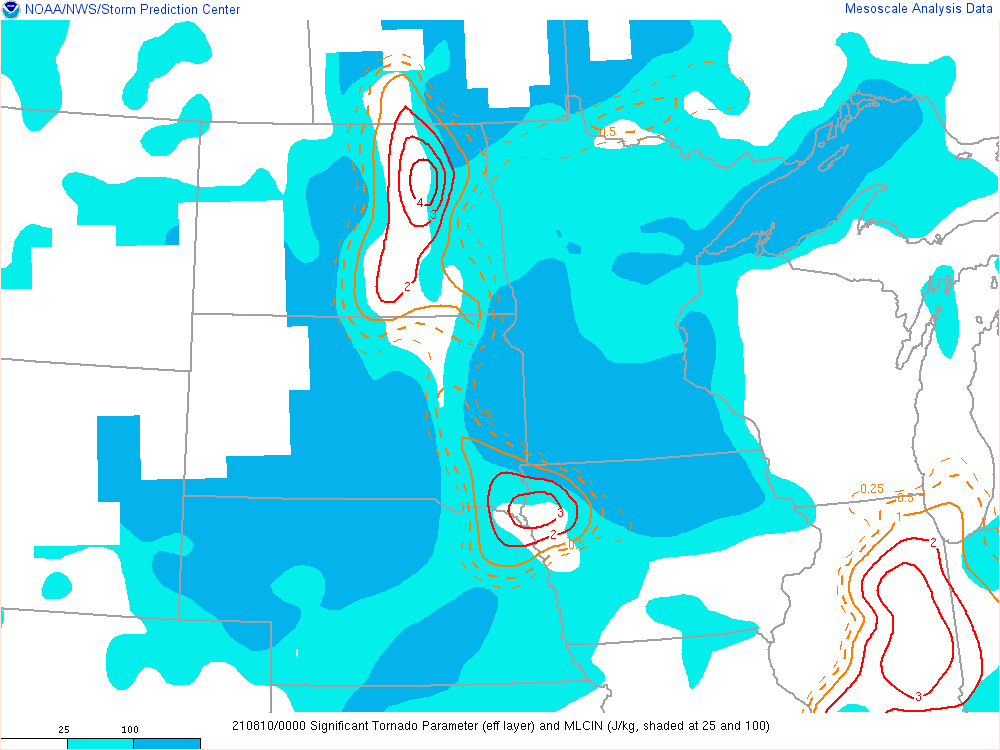
Effective Significant Tornado Parameter (00z) |
Differential Vorticity Advection (00z) |
 |
Media use of NWS Web News Stories is encouraged! Please acknowledge the NWS as the source of any news information accessed from this site. |
|

