Overview
A strong winter storm developed as a upper level trough moved across the Northern Plains. Initially light freezing rain and snow caused dangerous travel conditions as this system was approaching Friday January 17. Strong southeast winds gusting as high as 60 mph resulted in blowing snow and even whiteout conditions across southeast North Dakota and the Red River Valley in Minnesota through the day on the 17th. Eventually heavy snow spread across the region from the south to the north late afternoon through the night, with several bands resulting in higher totals in excess of 8 inches. While there was a lull in winds as they shifted, strong northwest winds arrived during the nighttime period and blizzard conditions developed across the entire Red River Valley into the Devils Lake Basin. These blizzard conditions continued through the afternoon Saturday January 18th mainly in the open country.

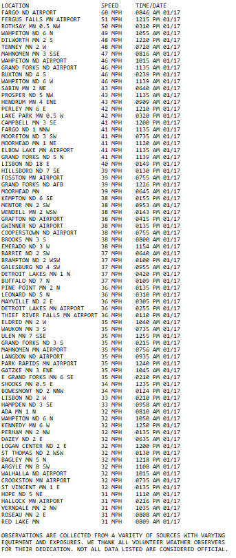
Friday Peak Winds (From the Southeast)
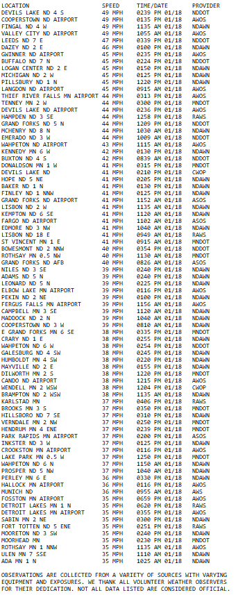
Saturday Peak Winds (From the Northwest)
Snow Reports

Photos & Video
|
|
 |
 |
 |
 |
|
Highway 10 Clay County, MN Courtesy Sgt. Jesse Grabow MNHP |
Near Fargo, ND Courtesy NDHP |
Cass County ND Courtesy Cass County Sheriff |
Icy roads in Fargo, ND before Blizzard started. Courtesy NDHP |
Radar
Environment
The upper level synoptic wave that was responsible for bringing the January 17-18th blizzard to the northern Plains came onshore across the Pacific northwest on January 16th and brought widespread snowfall to Oregon and Washington (Figure 1). As the wave translated eastward into the 17th a strong region of low pressure developed ahead of the wave on the lee side of the Rockies across Montana and Wyoming. At the same time, a departing upper level ridge with a strong upper level jet streak was supporting a strong region of high pressure at the surface. With two strengthening but opposing surface pressure features in close proximity to each other, winds at the low to mid levels began to increase in response to the tightening pressure gradient. Strong winds on the morning of January 17th began to loft snow that was already in place from snow events days prior. This cause areas of blowing snow and blizzard conditions across the southern Red River Valley.
As these winds increased, so did the mid level warm air advection (Figures 3, 8, and 9). An ejecting mid level shortwave embedded within the large wave helped increase lift over the eastern Dakotas and western Minnesota. This began to produce widespread snowfall that worsened conditions across the region, particularly in the southern Red River Valley where blowing snow was already impacting travel. Snowfall continued well into the overnight hours due to continued strong warm air advection and strong frontogenetical and deformation banding.
There was a brief lull in the surface winds during the overnight hours as the low pressure moved from the lee of the Rockies into the eastern Dakotas. A cold front following closely behind the low brought a second round of strong wind and cold, arctic air. As light snow lingered across the region into Saturday, strong winds blew the fresh snow pack leading to a second onslaught of blizzard conditions across the eastern Dakotas and portions of western Minnesota. As the low pressure system and snowfall continued east into Saturday night winds calmed and the snow came to an end, leaving frigid temperatures and nearly a half foot of snow for most of the region.
 |
 |
 |
| Figure 1: 300 mb Analysis | Figure 2: 500 mb Analysis | Figure 3: 700 mb Analysis |
 |
 |
 |
| Figure 4: 850 mb Analysis | Figure 5: 925 mb Analysis | Figure 6: Surface Analysis |
 |
 |
 |
| Figure 7: Precipitable Water Analysis | Figure 8: Aberdeen, SD Soundings | Figure 9: Bismarck, ND Soundings |
 |
Media use of NWS Web News Stories is encouraged! Please acknowledge the NWS as the source of any news information accessed from this site. |
|

