
Heavy snow will impact the region this evening into Saturday. Read More >
Overview
After the January 27th, 2019 Blizzard, a blast of frigid Arctic air pushed into the Plains and Great Lakes regions. Near record cold air inundated much of the central U.S. from Tuesday, January 29th through Thursday, January 31st, 2019. Cold air plunged in with northerly winds of 20 to 35 mph with gusts to 45 mph on Tuesday, January 29th. Observed temperatures were so far below average that they were near the record lows, particularly on Wednesday January 30th and Thursday January 31st. High temperatures on Wednesday January 30th were within a few degrees of the coldest high temperatures for this date in recorded history.
Wind chill temperatures in the 50s to 60s below zero were reported across the region on Tuesday, January 29th, in addition to limited visibility due to blowing snow. For the Grand Forks Airport (KGFK) the coldest wind chill for this event was -61 F recorded at 1153 AM CST on 1/29/2019. For a historical comparison, the coldest wind chill temperatures (WCT) on record for the period from 1948 to present at KGFK were on February 1st and 2nd, 1996. The coldest WCT in this period was -65 F at 9 am CST on 2/1/1996. For Fargo Airport (KFAR), the coldest wind chill for this event was -56 F at 521 PM CST on 1/29/2019. The coldest WCT on record for the period of 1948 to present at KFAR was on January 19th, 1985, at 8am CST when -61 F was recorded.
Low Temperatures:
Observed temperatures were so far below average that they were near the record lows, particularly on Wednesday January 30th and Thursday January 31st. Record and observed low temperatures for the coldest dates, January 30th and 31st, are listed and shown on maps below for various sites.
Here are the record and observed minimum temperatures at the Grand Forks and Fargo climate sites on the coldest dates.
| City | 01/30/2019 Observed Min | 01/30 Record Min | 01/31/2019 Observed Min | 01/31 Record Min |
| Grand Forks Airport (GFK) | -35 F | -43 F (2004) |
-32 F, new record |
Old record of -29 F (1996) |
| Grand Forks NWS (FGF) | -34 F | -39 F (2004) | -27 F | -32 F (1916) |
| Fargo Airport (FAR) | -33 F | -36F (2004) | -26 F | -29 F (1996) |
Record Low
No records were broken on January 30th, but one record low was broken on January 31st.
RECORD EVENT REPORT
NATIONAL WEATHER SERVICE EASTERN NORTH DAKOTA/GRAND FORKS
1000 AM CST THU JAN 31 2019

...RECORD LOW TEMPERATURE SET AT GRAND FORKS INTL AP ND...

 A RECORD LOW TEMPERATURE OF -32 DEGREES WAS SET AT GRAND FORKS INTL
AP ND TODAY. THIS BREAKS THE OLD RECORD OF -29 SET IN 1996.
Low Temperatures - Wednesday, January 30th
Below is a list and map depicting observed low temperatures for Wednesday, January 30th, 2019.
Public Information Statement
National Weather Service Grand Forks ND
1155 AM CST Wed Jan 30 2019

...LOW TEMPERATURE REPORTS...

Airports and Cooperative Observer Locations Only

Location                     Temp      Time/Date
Norris Camp (COOP)           -48 F     0700 AM 01/30
Lisbon ND (COOP)             -46 F     0700 AM 01/30
Park Rapids MN (Airport)     -42 F     0753 AM 01/30
Cavalier ND (Airport)        -38 F     0735 AM 01/30
Mahnomen MN (Airport)        -38 F     0755 AM 01/30
Walhalla ND (Airport)        -38 F     0855 AM 01/30
Cando ND (Airport)           -38 F     0735 AM 01/30
Bemidji MN (Airport)         -38 F     0756 AM 01/30
Langdon ND (Airport)         -38 F     0855 AM 01/30
Fosston MN (Airport)         -38 F     0916 AM 01/30
Red Lake Falls MN (COOP)     -38 F     0700 AM 01/30
Warroad MN (Airport)         -38 F     0836 AM 01/30
Staples MN (Airport)         -38 F     0816 AM 01/30
Thief River Falls MN (Arpt)  -38 F     0756 AM 01/30
Baudette MN (Airport)        -37 F     0753 AM 01/30
Esmond ND 9 NNW (COOP)       -37 F     0800 AM 01/30
Pembina ND (COOP)            -37 F     0700 AM 01/30
Sabin MN (UCOOP)             -37 F     0700 AM 01/30
Crookston MN (Airport)       -36 F     0836 AM 01/30
Devils Lake ND (Airport)     -36 F     0856 AM 01/30
Flag Island MN (AWOS)        -36 F     0915 AM 01/30
Hallock MN (Airport)         -36 F     0856 AM 01/30
New York Mills MN (COOP)     -36 F     0730 AM 01/30
Grand Forks AFB ND (ASOS)    -36 F     0656 AM 01/30
Roseau MN (Airport)          -36 F     0659 AM 01/30
Waskish MN (Airport)         -36 F     0835 AM 01/30
Wadena MN (Airport)          -35 F     0835 AM 01/30
Cavalier ND 7 NW (COOP)      -35 F     0700 AM 01/30
Fergus Falls MN (Airport)    -35 F     0835 AM 01/30
Grand Forks ND (Airport)     -35 F     0753 AM 01/30
Mcleod ND 3 E (COOP)         -35 F     0840 AM 01/30
Mayville ND (COOP)           -35 F     0700 AM 01/30
Ottertail MN (COOP)          -35 F     0511 AM 01/30
Cooperstown ND (Airport)     -35 F     0815 AM 01/30
Elbow Lake MN (Airport)      -35 F     0759 AM 01/30
Casselton ND (COOP)          -34 F     0800 AM 01/30
Grand Forks NWS ND (COOP)    -34 F     0655 AM 01/30
Sebeka MN (UCOOP)            -34 F     0700 AM 01/30
Breckenridge MN 3 SE (COOP)  -33 F     0700 AM 01/30
Wahpeton ND (Airport)        -33 F     0750 AM 01/30
Detroit Lakes MN (Airport)   -33 F     0755 AM 01/30
Fargo ND (Airport)           -33 F     0653 AM 01/30
Gwinner ND (Airport)         -33 F     0815 AM 01/30
Lidgerwood ND (COOP)         -33 F     0700 AM 01/30
Grafton ND (Airport)         -31 F     0855 AM 01/30

Observations are collected from a variety of sources with varying
equipment and exposures. We thank all volunteer weather observers
for their dedication. Not all data listed are considered official.
Observed Low temperatures valid the morning of January 30th, 2019

Low Temperatures - Thursday, January 31st
Below is a list and map depicting observed low temperatures for Wednesday, January 31st, 2019.
Public Information Statement
National Weather Service Grand Forks ND
826 AM CST Thu Jan 31 2019

...LOW TEMPERATURE REPORTS OVER THE PAST 12 HOURS...

Location                     Temp      Time/Date       Provider
Shooks MN (DOT)              -48 F     0615 AM 01/31   MNDOT
Chamberlain MN (DOT)         -48 F     0345 AM 01/31   MNDOT
Badoura MN (MN DNR)          -47 F     0706 AM 01/31   RAWS
Park Rapids MN (Airport)     -45 F     0335 AM 01/31   ASOS
Goodridge MN 12 NNW (USCRN)  -44 F     0235 AM 01/31   NOAA
Bemidji MN (MN DNR)          -43 F     0406 AM 01/31   RAWS
Kelliher MN (MN DNR)         -42 F     0607 AM 01/31   RAWS
Gatzke MN 9 SW (MN DNR)      -41 F     0320 AM 01/31   RAWS
Baudette MN (MN DNR)         -41 F     0606 AM 01/31   RAWS
Waskish MN 3 NW (DOT)        -41 F     0345 AM 01/31   MNDOT
Frazee MN 3 E (CWOP)         -40 F     0735 AM 01/31   CWOP
Mentor MN 2 SW (CWOP)        -40 F     0848 PM 01/30   CWOP
Verndale MN (DOT)            -40 F     0530 AM 01/31   MNDOT
Roosevelt MN (DOT)           -40 F     0400 AM 01/31   MNDOT
Ross MN (HADS)               -40 F     0600 AM 01/31   HADS
Waskish MN (Airport)         -40 F     0615 AM 01/31   ASOS
Ponsford MN 10 N (CWOP)      -39 F     0448 AM 01/31   CWOP
Baudette MN (Airport)        -39 F     0653 AM 01/31   ASOS
Detroit Lakes MN (MN DNR)    -39 F     0320 AM 01/31   RAWS
Gatzke MN (DOT)              -39 F     0410 AM 01/31   MNDOT
Wadena MN (Airport)          -38 F     0656 AM 01/31   ASOS
Bemidji MN (Airport)         -38 F     0116 AM 01/31   ASOS
Ottertail MN (DOT)           -38 F     0500 AM 01/31   MNDOT
Wilton MN 2 E (GPSMET)       -38 F     0700 AM 01/31   GPSMET
Roosevelt MN 2 ESE (GPSMET)  -38 F     0300 AM 01/31   GPSMET
Roseau MN (MN DNR)           -38 F     0408 AM 01/31   RAWS
Warroad MN (Airport)         -38 F     0336 AM 01/31   ASOS
Staples MN (Airport)         -38 F     0735 AM 01/31   ASOS
Detroit Lakes MN 2 SE (CWOP) -37 F     0303 AM 01/31   CWOP
Cavalier ND (Airport)        -36 F     1035 PM 01/30   ASOS
Walhalla ND (Airport)        -36 F     0255 AM 01/31   ASOS
Fosston MN (Airport)         -36 F     0636 AM 01/31   ASOS
Mahnomen MN (DOT)            -36 F     0205 AM 01/31   MNDOT
Ottertail MN (COOP)          -36 F     0705 AM 01/31   COOP
Roseau MN (Airport)          -36 F     0314 AM 01/31   ASOS
Bemidji MN (AWS)             -35 F     0805 AM 01/31   AWS
Flag Island MN (AWOS)        -35 F     0756 AM 01/31   ASOS
Red Lake HS (MN) (AWS)       -35 F     0549 AM 01/31   AWS
Itasca MN (MN DNR)           -34 F     0600 AM 01/31   RAWS
Brooks MN (DOT)              -34 F     0400 AM 01/31   MNDOT
Thief River Falls MN (Airpor -34 F     0556 AM 01/31   ASOS
Warroad MN 4W                -34 F     1000 PM 01/30   UCOOP
Mahnomen MN (Airport)        -33 F     0455 AM 01/31   ASOS
Crookston MN (Airport)       -33 F     1256 AM 01/31   ASOS
Langdon ND (Airport)         -33 F     1235 AM 01/31   ASOS
Detroit Lakes MN (Airport)   -33 F     0415 AM 01/31   ASOS
Badger MN (DOT)              -33 F     0500 AM 01/31   MNDOT
New York Mills MN (COOP)     -33 F     0730 AM 01/31   COOP
Grand Forks AFB ND (ASOS)    -33 F     0556 AM 01/31   ASOS
Sabin MN (HADS)              -33 F     0130 AM 01/31   HADS
Fergus Falls MN (AWS)        -32 F     0129 AM 01/31   AWS
Grand Forks ND (Airport)     -32 F     0553 AM 01/31   ASOS
St Vincent MN (DOT)          -32 F     0305 AM 01/31   MNDOT
Cando ND (Airport)           -31 F     0115 AM 01/31   ASOS
Grafton ND (Airport)         -31 F     1235 AM 01/31   ASOS
Hallock MN (Airport)         -31 F     1156 PM 01/30   ASOS
Donaldson MN (DOT)           -31 F     0120 AM 01/31   MNDOT
Bowesmont ND (DOT)           -31 F     1239 AM 01/31   NDDOT
Devils Lake ND (Airport)     -30 F     0956 PM 01/30   ASOS
Munich ND (AWS)              -30 F     0245 AM 01/31   AWS
Hampden ND (USFW)            -30 F     0158 AM 01/31   RAWS
Karlstad MN (MN DNR)         -30 F     0306 AM 01/31   RAWS
Lisbon ND (COOP)             -30 F     0700 AM 01/31   COOP
Tenney MN (DOT)              -30 F     0235 AM 01/31   MNDOT
Fergus Falls MN 6 SW (HADS)  -30 F     0130 AM 01/31   HADS
Red Lake Falls MN (AWS)      -30 F     0524 AM 01/31   AWS
Fergus Falls MN (Airport)    -29 F     1236 AM 01/31   ASOS
Gwinner ND (Airport)         -29 F     0315 AM 01/31   ASOS
Hendrum MN (DOT)             -29 F     1011 PM 01/30   MNDOT
Lake Park MN (DOT)           -29 F     0530 AM 01/31   MNDOT
Leeds ND (DOT)               -29 F     1239 AM 01/31   NDDOT
Cooperstown ND (Airport)     -29 F     1255 AM 01/31   ASOS
Elbow Lake MN (Airport)      -29 F     0559 AM 01/31   ASOS
Rothsay MN (DOT)             -28 F     0245 AM 01/31   MNDOT
Moorhead MN (DOT)            -28 F     0310 AM 01/31   MNDOT
Pembina ND (COOP)            -28 F     0700 AM 01/31   COOP
Wahpeton ND (Airport)        -27 F     0150 AM 01/31   ASOS
Grand Forks ND 5 WSW (CWOP)  -27 F     0346 AM 01/31   CWOP
Harwood ND (CWOP)            -27 F     0316 AM 01/31   CWOP
Fargo ND (CWOP)              -27 F     0418 AM 01/31   CWOP
Grand Forks ND (NWS)         -27 F     0425 AM 01/31   COOP
E Grand Forks MN (DOT)       -27 F     0515 AM 01/31   MNDOT
Devils Lake ND (DOT)         -27 F     0139 AM 01/31   NDDOT
Moorhead MN (CWOP)           -26 F     0110 AM 01/31   CWOP
Fargo ND (Airport)           -26 F     1253 AM 01/31   ASOS
Mayville ND (COOP)           -25 F     0700 AM 01/31   COOP
Fort Totten ND (USFW)        -24 F     0151 AM 01/31   RAWS
Sabin MN (UCOOP)             -24 F     0755 AM 01/31   UCOOP
Breckenridge MN 3 SE (COOP)  -23 F     0700 AM 01/31   COOP
Lidgerwood ND (COOP)         -21 F     0700 AM 01/31   COOP

Observations are collected from a variety of sources with varying
equipment and exposures. We thank all volunteer weather observers
for their dedication. Not all data listed are considered official.
Observed Low temperatures valid the morning of January 30th, 2019

High Temperatures
High temperatures on Wednesday January 30th were within a few degrees of the coldest high temperatures for this date in recorded history. A list and map depicting these values are listed below.
...HIGH TEMPERATURE REPORTS...

Location                     Temp      Time/Date       Provider
Fort Totten ND (USFW)        -13 F     1200 AM 01/31   RAWS
Grand Forks AFB ND (ASOS)    -14 F     1156 PM 01/30   ASOS
Badoura MN (MN DNR)          -15 F     0206 PM 01/30   RAWS
Grand Forks ND 5 WSW (CWOP)  -15 F     0447 PM 01/30   CWOP
Chamberlain MN (DOT)         -15 F     0305 PM 01/30   MNDOT
Moorhead MN (DOT)            -15 F     0335 PM 01/30   MNDOT
Baudette MN (MN DNR)         -16 F     0306 PM 01/30   RAWS
Cavalier ND (Airport)        -17 F     0315 PM 01/30   ASOS
Cando ND (Airport)           -17 F     1155 PM 01/30   ASOS
Langdon ND (Airport)         -17 F     0315 PM 01/30   ASOS
Harwood ND (CWOP)            -17 F     0400 PM 01/30   CWOP
Grand Forks ND (NWS)         -17 F     0410 PM 01/30   COOP
Hampden ND (USFW)            -17 F     1200 AM 01/31   RAWS
Itasca MN (MN DNR)           -17 F     1200 AM 01/31   RAWS
E Grand Forks MN (DOT)       -17 F     0111 PM 01/30   MNDOT
Devils Lake ND (DOT)         -17 F     0509 PM 01/30   NDDOT
Fergus Falls MN 6 SW (HADS)  -17 F     0415 PM 01/30   HADS
Cooperstown ND (Airport)     -17 F     1155 PM 01/30   ASOS
Thief River Falls MN (Airpor -17 F     1156 PM 01/30   ASOS
Walhalla ND (Airport)        -18 F     0435 PM 01/30   ASOS
Wahpeton ND (Airport)        -18 F     0510 PM 01/30   ASOS
Moorhead MN (CWOP)           -18 F     0335 PM 01/30   CWOP
Fargo ND (Airport)           -18 F     1153 PM 01/30   ASOS
Fosston MN (Airport)         -18 F     0316 PM 01/30   ASOS
Grafton ND (Airport)         -18 F     0435 PM 01/30   ASOS
Grand Forks ND (Airport)     -18 F     1153 PM 01/30   ASOS
Gwinner ND (Airport)         -18 F     1155 PM 01/30   ASOS
Tenney MN (DOT)              -18 F     0420 PM 01/30   MNDOT
Red Lake Falls MN (AWS)      -18 F     0339 PM 01/30   AWS
Bemidji MN (MN DNR)          -19 F     0306 PM 01/30   RAWS
Devils Lake ND (Airport)     -19 F     1156 PM 01/30   ASOS
Fargo ND (CWOP)              -19 F     0442 PM 01/30   CWOP
Munich ND (AWS)              -19 F     0110 PM 01/30   AWS
Hendrum MN (DOT)             -19 F     0216 PM 01/30   MNDOT
Bowesmont ND (DOT)           -19 F     0124 PM 01/30   NDDOT
Leeds ND (DOT)               -19 F     0439 PM 01/30   NDDOT
Park Rapids MN (Airport)     -19 F     1153 PM 01/30   ASOS
Thorhult MN                  -19 F     0500 PM 01/30   COOP
Warroad MN 4W                -19 F     1000 PM 01/30   UCOOP
Wadena MN (Airport)          -20 F     0435 PM 01/30   ASOS
Detroit Lakes MN 2 SE (CWOP) -20 F     0338 PM 01/30   CWOP
Crookston MN (Airport)       -20 F     0435 PM 01/30   ASOS
Detroit Lakes MN (Airport)   -20 F     0436 PM 01/30   ASOS
Fergus Falls MN (Airport)    -20 F     0435 PM 01/30   ASOS
Flag Island MN (AWOS)        -20 F     0536 PM 01/30   ASOS
Hallock MN (Airport)         -20 F     0455 PM 01/30   ASOS
Karlstad MN (MN DNR)         -20 F     0206 PM 01/30   RAWS
Rothsay MN (DOT)             -20 F     0340 PM 01/30   MNDOT
Waskish MN 3 NW (DOT)        -20 F     0115 PM 01/30   MNDOT
St Vincent MN (DOT)          -20 F     0305 PM 01/30   MNDOT
Verndale MN (DOT)            -20 F     0410 PM 01/30   MNDOT
Roseau MN (Airport)          -20 F     0456 PM 01/30   ASOS
Ross MN (HADS)               -20 F     0330 PM 01/30   HADS
Gatzke MN 9 SW (MN DNR)      -21 F     0320 PM 01/30   RAWS
Ponsford MN 10 N (CWOP)      -21 F     0233 PM 01/30   CWOP
Baudette MN (Airport)        -21 F     1153 PM 01/30   ASOS
Bemidji MN (AWS)             -21 F     0420 PM 01/30   AWS
Detroit Lakes MN (MN DNR)    -21 F     0320 PM 01/30   RAWS
Kelliher MN (MN DNR)         -21 F     0307 PM 01/30   RAWS
Donaldson MN (DOT)           -21 F     0500 PM 01/30   MNDOT
Ottertail MN (DOT)           -21 F     0410 PM 01/30   MNDOT
Roosevelt MN (DOT)           -21 F     0340 PM 01/30   MNDOT
Roseau MN (MN DNR)           -21 F     0408 PM 01/30   RAWS
Bemidji MN (Airport)         -22 F     0335 PM 01/30   ASOS
Frazee MN 3 E (CWOP)         -22 F     0334 PM 01/30   CWOP
Mentor MN 2 SW (CWOP)        -22 F     0338 PM 01/30   CWOP
Fergus Falls MN (AWS)        -22 F     0424 PM 01/30   AWS
Gatzke MN (DOT)              -22 F     0420 PM 01/30   MNDOT
Wilton MN 2 E (GPSMET)       -22 F     0400 PM 01/30   GPSMET
Roosevelt MN 2 ESE (GPSMET)  -22 F     0500 PM 01/30   GPSMET
Warroad MN (Airport)         -22 F     0435 PM 01/30   ASOS
Sabin MN (HADS)              -22 F     0230 PM 01/30   HADS
Staples MN (Airport)         -22 F     0416 PM 01/30   ASOS
Waskish MN (Airport)         -22 F     0435 PM 01/30   ASOS
Elbow Lake MN (Airport)      -22 F     1159 PM 01/30   ASOS
Mahnomen MN (Airport)        -23 F     0435 PM 01/30   ASOS
Shooks MN (DOT)              -23 F     0420 PM 01/30   MNDOT
Badger MN (DOT)              -23 F     0420 PM 01/30   MNDOT
Mahnomen MN (DOT)            -23 F     0320 PM 01/30   MNDOT
Lake Park MN (DOT)           -23 F     0510 PM 01/30   MNDOT
Goodridge MN 12 NNW (USCRN)  -24 F     0435 PM 01/30   NOAA
Brooks MN (DOT)              -24 F     0340 PM 01/30   MNDOT
Red Lake HS (MN) (AWS)       -25 F     0344 PM 01/30   AWS

Observations are collected from a variety of sources with varying
equipment and exposures. We thank all volunteer weather observers
for their dedication. Not all data listed are considered official.

$$
Observed Low temperatures valid the morning of January 30th, 2019

Wind Chill Temperatures
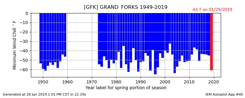
For the Grand Forks International Airport (KGFK) the coldest wind chill temperature (WCT) on record for the period from 1948 to present were on February 1st and 2nd, 1996. The coldest WCT was -65 F at 9 am CST on 2/1/1996. The coldest wind chill at GFK for this event was -61 F recorded at 1153 AM CST on 1/29/2019. Below is a climate graph from the Midwest Regional Climate Center. This graph shows the coldest wind chills each year (blue bars) on record at KGFK. You can see that a wind chill below -60 F only occurs about once every 10 to 15 years and the last time this cold of a wind chill occurred was in January 2004.
For Fargo Hector International Airport (KFAR), the coldest WCT on record for the period of 1948 to present was on January 19th, 1985, at 8am CST when -61 F was recorded. The coldest wind chill at FAR for this event was -56 F at 521 PM CST on 1/29/2019. Below is a climate graph from the Midwest Regional Climate Center. This graph shows the coldest wind chills each year (blue bars) on record at KFAR. You can see that a wind chill below -56 F only occurs about once every 10 to 15 years and the last time this cold of a wind chill occurred was in January 2004.

These values have been recalculated based on the updated wind chill formula, which was implemented in 2001. Below is a list and a map depicting the coldest wind chill reports for the past 48 hours ending at noon on Wednesday, January 30th.
Public Information Statement
National Weather Service Grand Forks ND
1226 PM CST Wed Jan 30 2019

...COLDEST WIND CHILL REPORTS OVER THE PAST 48 HOURS...

Location                     Temp      Time/Date       Provider
Ponsford MN 10 N (CWOP)      -66 F     0618 PM 01/29   CWOP
Flag Island MN (AWOS)        -65 F     0735 AM 01/30   ASOS
Lake Park MN (DOT)           -64 F     0545 PM 01/29   MNDOT
Brooks MN (DOT)              -64 F     0545 PM 01/29   MNDOT
Park Rapids MN (Airport)     -64 F     0753 AM 01/30   ASOS
Staples MN (Airport)         -64 F     0816 PM 01/29   ASOS
Thief River Falls MN (Airpor -64 F     0506 PM 01/29   ASOS
Mahnomen MN (Airport)        -63 F     0630 PM 01/29   ASOS
Bemidji MN (Airport)         -63 F     0815 PM 01/29   ASOS
Fosston MN (Airport)         -63 F     0535 PM 01/29   ASOS
Donaldson MN (DOT)           -63 F     0515 PM 01/29   MNDOT
Mahnomen MN (DOT)            -63 F     0605 PM 01/29   MNDOT
Gatzke MN (DOT)              -63 F     0435 AM 01/30   MNDOT
Wadena MN (Airport)          -62 F     0955 PM 01/29   ASOS
Crookston MN (Airport)       -62 F     0536 PM 01/29   ASOS
Fergus Falls MN (AWS)        -62 F     0749 PM 01/29   AWS
Fergus Falls MN (Airport)    -62 F     0756 PM 01/29   ASOS
Grafton ND (Airport)         -62 F     1055 AM 01/29   ASOS
Munich ND (AWS)              -62 F     1220 PM 01/29   AWS
Rothsay MN (DOT)             -62 F     0605 PM 01/29   MNDOT
Badger MN (DOT)              -62 F     0545 PM 01/29   MNDOT
Verndale MN (DOT)            -62 F     0545 AM 01/30   MNDOT
Cavalier ND (Airport)        -61 F     1155 AM 01/29   ASOS
Walhalla ND (Airport)        -61 F     1115 AM 01/29   ASOS
Detroit Lakes MN (DNR)       -61 F     0820 PM 01/29   RAWS
Frazee MN 3 E (CWOP)         -61 F     0704 PM 01/29   CWOP
Grand Forks ND (Airport)     -61 F     1153 AM 01/29   ASOS
Chamberlain MN (DOT)         -61 F     0805 AM 01/30   MNDOT
Hendrum MN (DOT)             -61 F     0401 PM 01/29   MNDOT
E Grand Forks MN (DOT)       -61 F     0505 PM 01/29   MNDOT
Red Lake HS (MN) (AWS)       -61 F     0734 AM 01/30   AWS
Cooperstown ND (Airport)     -61 F     0415 PM 01/29   ASOS
Langdon ND (Airport)         -60 F     0655 AM 01/30   ASOS
Detroit Lakes MN (Airport)   -60 F     0635 PM 01/29   ASOS
Shooks MN (DOT)              -60 F     0745 AM 01/30   MNDOT
Tenney MN (DOT)              -60 F     0645 PM 01/29   MNDOT
Baudette MN (Airport)        -59 F     0753 AM 01/30   ASOS
Badoura MN (MN DNR)          -59 F     0806 AM 01/30   RAWS
Bemidji MN (MN DNR)          -59 F     0806 PM 01/29   RAWS
Devils Lake ND (Airport)     -59 F     0951 AM 01/29   ASOS
Hallock MN (Airport)         -59 F     0255 PM 01/29   ASOS
Ottertail MN (DOT)           -59 F     0735 PM 01/29   MNDOT
Devils Lake ND (DOT)         -59 F     1224 AM 01/30   NDDOT
Roseau MN (MN DNR)           -59 F     0608 AM 01/30   RAWS
Warroad MN (Airport)         -59 F     0615 AM 01/30   ASOS
Elbow Lake MN (Airport)      -59 F     0559 AM 01/30   ASOS
Roseau MN (Airport)          -58 F     0620 AM 01/30   ASOS
Waskish MN (Airport)         -58 F     0616 AM 01/30   ASOS
Cando ND (Airport)           -57 F     0635 AM 01/30   ASOS
Gatzke MN 9 SW (DNR)         -57 F     0620 AM 01/30   RAWS
Wahpeton ND (Airport)        -57 F     0730 PM 01/29   ASOS
Karlstad MN (MN DNR)         -57 F     0506 PM 01/29   RAWS
Leeds ND (DOT)               -57 F     0639 AM 01/30   NDDOT
Grand Forks AFB ND (ASOS)    -57 F     0343 PM 01/29   ASOS
Red Lake Falls MN (AWS)      -57 F     0209 PM 01/29   AWS
Fargo ND (Airport)           -56 F     0521 PM 01/29   ASOS
Itasca MN (MN DNR)           -56 F     0807 PM 01/29   RAWS
Fergus Falls MN 6 SW (HADS)  -56 F     0730 PM 01/29   HADS
Gwinner ND (Airport)         -55 F     0455 PM 01/29   ASOS
Bemidji MN (AWS)             -54 F     0305 AM 01/30   AWS
Kelliher MN (MN DNR)         -54 F     0807 AM 01/30   RAWS
Baudette MN (MN DNR)         -52 F     0806 AM 01/30   RAWS
Fargo ND (CWOP)              -51 F     0550 PM 01/29   CWOP
Moorhead MN (DOT)            -51 F     0435 PM 01/29   MNDOT
Grand Forks ND 5 WSW (CWOP)  -49 F     1215 PM 01/29   CWOP
Mentor MN 2 SW (CWOP)        -48 F     0648 PM 01/29   CWOP
Moorhead MN (CWOP)           -46 F     0535 PM 01/29   CWOP
Detroit Lakes MN 2 SE (CWOP) -45 F     0643 PM 01/29   CWOP
Harwood ND (CWOP)            -43 F     0415 PM 01/29   CWOP
Fort Totten ND (USFW)        -43 F     0751 PM 01/29   RAWS

Many sites have varying times when coldest wind chills were reached.
Most sites that had coldest wind chills reached on 01/29 were mainly
due to the added influence of gusty winds during the daytime. Whereas
lowest wind chills acquired on 01/30 were mostly due to the extremely
cold combined with lighter winds.

Observations are collected from a variety of sources with varying
equipment and exposures. We thank all volunteer weather observers
for their dedication. Not all data listed are considered official.
Observed Minimum Wind Chill Temperatures valid noon 1/28 to noon 1/30

Storm Impacts
On Tuesday January 29th, gusty winds brought both limited visibility due to blowing snow as well as dangerously cold wind chills. On Wednesday through Thursday morning (January 30th-31st), the winds had subsided, but dangerously cold temperatures remained in place. Below is a list of impacts that the storm/extreme cold has brought to the region.
News articles cited:
https://kstp.com/news/bursting-water-pipes-reported-across-minnesota-deep-freeze/5228611/
Environment
Here's a loop of the GFS analyses and 3 hr forecasts showing the movement of the cold air. Notice the area of black, or air colder than -40 C at 850 mb (or approximately 3500 ft MSL).
Satellite loop 1: GOES-East Longwave Infrared Imagery
Since the atmosphere was so cold and dry, GOES-East was able to sample very cold temperatures on the surface over portions of the Upper Midwest and Canada, especially over the eastern Dakotas and Minnesota. Coldest temperatures are in pink whereas warmer temperatures are colder blue. The loop is valid from 2 PM CST on 1/29 to 230 PM CST on 1/30.
Satellite loop 2: GOES-East Airmass RGB Imagery
Forecasters were able to monitor the large upper level low pressure system and associated polar air mass underneath by using the GOES-East Airmass RGB. The large area colored in a yellow-orange over the Upper Midwest into Canada showed where this air mass resided. The loop is valid from 6 PM CST on 1/29 to 1030 AM CST on 1/30.
Satellite loop 3: GOES-East Day Snow/Fog Imagery
This loop shows the GOES-East Day Snow/Fog RGB over the Upper Midwest during the afternoon of January 29, 2019. Areas in red are snow pack on the ground, green is snowless ground, the whitish-blue color shows low clouds, the magenta-purple color high level clouds, and the orange-rust and grey colored streaks are blowing snow. Notice the vast area of blowing snow wrapping around the backside of a strong, large low pressure system from the Dakotas and Minnesota to Iowa and Illinois. Also of note in the loop are the lake effect snow bands particularly over Lake Michigan into the lower peninsula of Michigan as well as the counter-clockwise motion of clouds and blowing snow over the Upper Midwest. The loop is valid from noon CST to 530 PM CST on 1/29.
Additional Information
Below is a chart for determining the wind chill.

The NWS Wind Chill Temperature (WCT) index uses advances in science, technology, and computer modeling to provide an accurate, understandable, and useful formula for calculating the dangers from winter winds and freezing temperatures. The index does the following:
For wind chill safety information, click here.
 |
Media use of NWS Web News Stories is encouraged! Please acknowledge the NWS as the source of any news information accessed from this site. |
|

