Overview
Several supercell thunderstorms spawned tornadoes on this day across northeast ND and portions of northwest MN. These supercell storms produced at least 11 distinct tornadoes, along with numerous large hail and damaging downburst wind events. The largest and strongest of these supercells tracked southeastward for over 110 miles from its origin just west of Larimore ND, past Hillsboro ND and Halstad MN, and continued well east of Detroit Lakes MN, producing 4 of the 11 identified tornadoes, three of which were also the strongest and longest tracking (see descriptions below).
Both a ground survey and an aerial survey were conducted over this long storm track. These surveys showed evidence of the tornadoes forming and generally tracking southeastward, but occasionally exhibiting a slight curl to the ESE which was followed by a sharp plunge towards the SSE, usually accompanied at this point by an extreme Rear-Flank Downdraft (RFD) wind area, wrapping around to the west and south of the main tornado track. A good example of this would be Tornado Number 8, which radar imagery and corresponding ground swirl tracks showed as passing well to the northeast of Hillsboro ND, with EF2 tornadic scale winds of from 115-135 mph, while extreme downburst winds of from 80-100 mph raked across the community of Hillsboro itself.
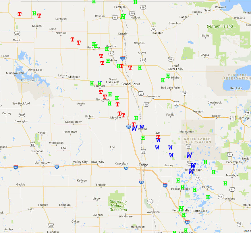
Tornadoes:
|
Tornado #1 - 4 E Rocklake, ND
Track Map   |
||||||||||||||||
|
Tornado #2 - 2 SSW Veseleyville, ND
Track Map  |
||||||||||||||||
|
Tornado #3 - 5 E Clyde, ND
Track Map  |
||||||||||||||||
|
Tornado #4 - 3 ENE Inkster, ND
Track Map  |
||||||||||||||||
|
Tornado #5 - 5 NNW Northwood, ND
Track Map  |
||||||||||||||||
|
Tornado #6 - 5 NW Adams, ND
Track Map  |
||||||||||||||||
|
Tornado #7 - 4 NNW Manvel, ND
Track Map  |
||||||||||||||||
|
Tornado #8 - 7 E Hatton/Hillsboro, ND
Track Map  |
||||||||||||||||
|
Tornado #9 - 6 SSW Alvarado-Tabor, MN
Track Map  |
||||||||||||||||
|
Tornado #10 - 4 ESE Hillsboro, ND to Halstad, MN
Track Map 
|
||||||||||||||||
|
Tornado #11 - 3N Borup to Ulen, MN
Track Map 
|
||||||||||||||||
The Enhanced Fujita (EF) Scale classifies tornadoes into the following categories:
| EF0 Weak 65-85 mph |
EF1 Moderate 86-110 mph |
EF2 Significant 111-135 mph |
EF3 Severe 136-165 mph |
EF4 Extreme 166-200 mph |
EF5 Catastrophic 200+ mph |
 |
|||||
Radar:
 |
 |
||
| Radar Loop 4pm-10pm | Radar Loop 7pm-1am | Base Reflectivity Tornadic Storm near Hillsboro ND | Storm Relative Velocity Tornadic Storm near Hillsboro ND |
Storm Reports
Link to Summary of Storm Reports
..TIME... ...EVENT... ...CITY LOCATION... ...LAT.LON... ..DATE... ....MAG.... ..COUNTY LOCATION..ST.. ...SOURCE.... ..REMARKS.. 0455 PM FUNNEL CLOUD AMOURDALE 48.87N 99.37W 07/11/2017 TOWNER ND PUBLIC FACEBOOK PHOTO OF POSSIBLE TORNADO SOUTH OF HANSBORO ND 0510 PM FUNNEL CLOUD 1 NE ROCKLAKE 48.80N 99.23W 07/11/2017 TOWNER ND LAW ENFORCEMENT FUNNEL CLOUD BEING MONITORED BY DEPUTY RELAYED VIA 911 CALL CENTER THROUGH NAWAS 0512 PM FUNNEL CLOUD 2 E ROCKLAKE 48.79N 99.20W 07/11/2017 TOWNER ND TRAINED SPOTTER POSSIBLE TORNADO VIEWED FROM NEAR CALVIN. 0516 PM TORNADO 4 E ROCKLAKE 48.79N 99.16W 07/11/2017 F0 TOWNER ND PUBLIC THE FUNNEL WHICH PRECEDED THIS TORNADO WAS VIEWED BY MULTIPLE STORM SPOTTERS. PHOTOGRAPHS AND REPORTS SHOW THAT THIS TORNADO TRACKED ESE FOR ABOUT 2 MILES OVER MAINLY OPENED RANGELAND AND LIFTED BY 520 PM CDT AROUN 6 ESE ROCKLAKE. PEAK WINDS ESTIMATED TO 70 MPH. MAXIMUM WIDTH ESTIMATED TO 150 YARDS. 0535 PM HAIL 4 NNW VOSS 48.35N 97.49W 07/11/2017 E1.50 INCH WALSH ND PUBLIC LARGE HAIL FELL FOR A GOOD 10 MINUTES ACROSS NORTHWEST WALSH CENTER TOWNSHIP. BEAN FIELDS STRIPPED. 0536 PM HAIL 2 NNE CLYDE 48.80N 98.88W 07/11/2017 E1.75 INCH CAVALIER ND PUBLIC 0539 PM TORNADO 2 SSW VESELEYVILLE 48.30N 97.57W 07/11/2017 F1 WALSH ND STORM CHASER PARTIALLY RAIN WRAPPED TORNADO BETWEEN PISEK AND VOSS. DAMAGE SURVEY FOUND LARGE BRANCHES DOWN AND A FEW FRESHLY SNAPPED POPLAR TREES IN SHELTER BELTS ALONG A NEARLY 2 MILE TRACK TO AROUND 4W VOSS BY 543. TRIM WAS DAMAGED ON A HOUSE AT ONE FARMSTEAD. PEAK WINDS ESTIMATED TO 95 MPH. MAXIMUM WIDTH TO 150 YARDS. 0544 PM FUNNEL CLOUD 3 NNW INKSTER 48.19N 97.60W 07/11/2017 GRAND FORKS ND TRAINED SPOTTER RAPIDLY PRODUCED WALL CLOUD, THEN FUNNEL DEVELOPED. COULD NOT DETERMINE WHETHER FUNNEL WAS REACHING THE GROUND 0548 PM TORNADO 5 E CLYDE 48.77N 98.79W 07/11/2017 F0 CAVALIER ND PUBLIC BRIEF TOUCHDOWN NOTED BY OBSERVER NEAR THE CORNER OF CR5 AND CR20. TORNADO LIKELY TRACKED OVER OPENED COUNTRY FOR LESS THAN A HALF MILE AND LIFTED BY 550 PM CDT. MAXIMUM WINDS ESTIMATED TO 70 MPH. MAXIMUM WIDTH TO 100 YARDS. TIME ESTIMATED BASED ON RADAR. 0550 PM HAIL 10 E CLYDE 48.77N 98.68W 07/11/2017 E1.75 INCH CAVALIER ND PUBLIC LARGE HAIL FELL FOR NEARLY 10 MINUTES. LARGE BRANCHES WERE BROKEN DOWN IN SHELTER BELTS AROUND WESTERN MOSCOW TOWNSHIP. 0551 PM TORNADO 3 ENE INKSTER 48.17N 97.58W 07/11/2017 F0 GRAND FORKS ND NWS STORM SURVEY A PERSISTENT FUNNEL CLOUD WITH INTERMITTENT TOUCHDOWNS WAS OBSERVED PASSING NORTHEAST OF INKSTER. DAMAGE SURVEY FOUND LARGE, FRESHLY BROKEN TREE BRANCHES AND LIMBS AT ONE FARMSTEAD AND IN SHELTER BELTS ALONG A ROUGHLY MILE LONG PATH. THE PATH ENDING AROUND 4ENE INSKSTER BY 553 PM CDT. PEAK WINDS ESTIMATED TO 75 MPH. MAXIMUM WIDTH TO 100 YARDS. 0600 PM HAIL 1 S FOREST RIVER 48.20N 97.47W 07/11/2017 E1.00 INCH WALSH ND TRAINED SPOTTER QUARTER SIZED HAIL VIA HAM RADIO 0603 PM HAIL 7 W LARIMORE 47.91N 97.78W 07/11/2017 E1.75 INCH GRAND FORKS ND PUBLIC 0608 PM FUNNEL CLOUD 3 SW LARIMORE 47.88N 97.67W 07/11/2017 GRAND FORKS ND STORM CHASER WALL CLOUD REPORTED AROUND 558 PM CDT ABOUT 6W OF LARIMORE. SUBSEQUENT FUNNEL WAS REPORTED AND PHOTO POSTED TO SOCIAL MEDIA. 0612 PM TSTM WND DMG N LARIMORE 47.91N 97.63W 07/11/2017 GRAND FORKS ND NWS STORM SURVEY NUMEROUS LARGE TREE BRANCHES AND LIMBS BROKEN DOWN IN SHELTER BELTS ACROSS NORTHEAST ELM GROVE TOWNSHIP. 0615 PM HAIL LARIMORE 47.91N 97.63W 07/11/2017 E1.00 INCH GRAND FORKS ND STORM CHASER 0618 PM HAIL 5 N BOWESMONT 48.76N 97.18W 07/11/2017 E2.50 INCH PEMBINA ND STORM CHASER LARGE HAIL COVERED THE INTERSTATE NEAR MP200. 0625 PM TORNADO 5 NNW NORTHWOOD 47.80N 97.61W 07/11/2017 F1 GRAND FORKS ND NWS STORM SURVEY THIS PARTIALLY RAIN WRAPPED TORNADO TRACKED INTERMITTENTLY TO THE SOUTHEAST FOR NEARLY 5 MILES TO AROUND 3 ENE OF NORTHWOOD BY 642 PM CDT. THE TORNADO BROKE DOWN LARGE BRANCHES AND SNAPPED A FEW TREE TRUNKS IN SHELTER BELTS ALONG IT PATH. MAXIMUM WIDTH ESTIMATED TO 150 YARDS. PEAK WINDS ESTIMATED TO 90 MPH. 0629 PM FUNNEL CLOUD 2 ENE FAIRDALE 48.50N 98.19W 07/11/2017 WALSH ND TRAINED SPOTTER LARGE CONE SHAPED FUNNEL WAS REPORTED NEAR FAIRDALE. 0630 PM TORNADO 5 NW ADAMS 48.47N 98.15W 07/11/2017 F1 WALSH ND STORM CHASER THIS ROPE TORNADO TRACKED FOR ROUGHLY 7 MILES TO THE EAST SOUTHEAST AND EVENTUALLY PRODUCED A SUBSTANTIAL DUST SWIRL BEFORE IT ENDED ABOUT 2 ENE OF ADAMS BY 646 PM CDT. IT WAS VIEWED AND PHOTOGRAPHED FROM MULTIPLE LOCATIONS. THOUGH IT REMAINED OVER LARGELY OPENED COUNTRY IT DID SNAPPED A FEW HARDWOOD TREE TRUNKS AT A COUPLE OF LOCATIONS. MAXIMUM WIDTH TO 150 YARDS. PEAK WINDS ESTIMATED TO 105 MPH. 0632 PM HAIL 1 W NORTHCOTE 48.85N 97.02W 07/11/2017 E1.00 INCH KITTSON MN LAW ENFORCEMENT DIME TO QUARTER SIZED HAIL FELL WEST OF NORTHCOTE 0640 PM HAIL 1 NW ORLEANS 48.94N 96.95W 07/11/2017 E1.75 INCH KITTSON MN PUBLIC HAIL SHREDDED CORN AND BEAN FIELDS 0641 PM HAIL 6 NW MANVEL 48.13N 97.27W 07/11/2017 E1.25 INCH GRAND FORKS ND TRAINED SPOTTER 0642 PM HAIL 7 ENE NORTHWOOD 47.77N 97.43W 07/11/2017 E1.75 INCH GRAND FORKS ND NWS STORM SURVEY LARGE HAIL AND STRONG WINDS DAMAGED CROPS ACROSS SOUTHERN PLEASANT VIEW TOWNSHIP. 0645 PM HAIL 2 NE ORLEANS 48.95N 96.91W 07/11/2017 E1.50 INCH KITTSON MN PUBLIC HAIL FOR 10 MINUTES WITH VARYING SIZES UP TO THE SIZE OF PING PONG BALLS 0650 PM TORNADO 4 NNW MANVEL 48.13N 97.21W 07/11/2017 F0 GRAND FORKS ND TRAINED SPOTTER THIS TORNADO WAS OBSERVED AND REPORTED BY SPOTTERS LOCATED NEAR MANVEL AND ALONG HWY 81 AND CR1 ABOUT 6 MILES NORTHWEST OF MANVEL. THE TORNADO TRACKED TO THE EAST FOR NEARLY 2 MILES AND CROSSED INTERSTATE 29 JUST SOUTH OF EXIT 157...BEFORE LIFTING AROUND 3.5 ENE OF MANVEL BY 656 PM CDT. THE TORNADO BROKE DOWN LARGE TREE BRANCHES AT MULTIPLE SHELTER BELTS AND GROVES ALONG ITS PATH. PEAK WINDS ESTIMATED TO 75 MPH. MAXIMUM WIDTH TO 150 YARDS. 0653 PM HAIL 2 W THOMPSON 47.78N 97.15W 07/11/2017 E0.50 INCH GRAND FORKS ND 911 CALL CENTER MARBLE SIZED HAIL REPORTED IN RURAL THOMPSON 0658 PM TORNADO 7 E HATTON 47.64N 97.31W 07/11/2017 F2 TRAILL ND NWS STORM SURVEY THIS MULTI-VORTEX TORNADO WAS WRAPPED IN RAIN AND HAIL FOR MUCH OF ITS PATH AS IT TRACKED PRIMARILY TO THE SOUTHEAST FOR OVER 22 MILES. IT CROSSED INTERSTATE 29 JUST NORTH OF THE TAFT ELEVATORS THEN DOVE SOUTH SOUTHEASTWARD TO A POINT ROUGHLY 2.5 ENE OF HILLSBORO WHERE IT CURLED TO THE NORTHEAST...ENDING ABOUT 4.5 ENE OF HILLSBORO BY 749 PM CDT. THE TORNADO SNAPPED TREES AND DESTROYED SEVERAL FARM BUILDINGS ALONG ITS PATH. MAXIMUM WIDTH ESTIMATED TO 1200 YARDS. PEAK WINDS ESTIMATED TO 135 MPH. 0659 PM HAIL 1 NE HATTON 47.65N 97.44W 07/11/2017 E1.75 INCH TRAILL ND TRAINED SPOTTER QUARTER TO GOLF BALL SIZED HAIL NORTHEAST OF HATTON 0700 PM HAIL 1 N PARK RIVER 48.41N 97.74W 07/11/2017 E1.50 INCH WALSH ND TRAINED SPOTTER 0701 PM HAIL HOLMES 47.72N 97.30W 07/11/2017 E1.00 INCH GRAND FORKS ND TRAINED SPOTTER 0707 PM TORNADO 6 SSW ALVARADO 48.11N 97.05W 07/11/2017 F1 POLK MN NWS STORM SURVEY THIS TORNADO TRACKED INTERMITTENTLY FOR NEARLY 10 MILES ACROSS NORTHERN NORTHLAND AND TABOR TOWNSHIPS... AND LIFTED AROUND 3 MILES EAST OF TABOR BY 730 PM CDT. THE TORNADO SNAPPED OR UPROOTED A FEW SPRUCE TREES AND BROKE DOWN NUMEROUS LARGE BRANCHES IN SHELTER BELTS ALONG ITS PATH. AT ONE FARMSTEAD EAST OF TABOR IT TORE STEEL PANELS OFF OFF OF SHED ROOF AND SNAPPED LARGE TREE LIMBS. MAXIMUM WIDTH ESTIMATED TO 250 YARDS. PEAK WINDS ESTIMATED TO 95 MPH. 0720 PM HAIL 7 ESE PARK RIVER 48.35N 97.60W 07/11/2017 E1.00 INCH WALSH ND PUBLIC 0723 PM HAIL 2 N TABOR 48.11N 96.86W 07/11/2017 E1.75 INCH POLK MN NWS STORM SURVEY HAIL UP TO GOLF BALL SIZED FELL ACROSS NORTHWEST TOBOR TOWNSHIP. 0735 PM HAIL 2 NNE LEROY 48.95N 97.74W 07/11/2017 E1.00 INCH PEMBINA ND PUBLIC 0748 PM TORNADO 4 ESE HILLSBORO 47.38N 96.98W 07/11/2017 F2 TRAILL ND NWS STORM SURVEY THIS TORNADO DEVELOPED FROM THE MAIN MESOCYCLONE AS ITS PREDECESSOR ROPED OUT. IT TRACKED ESE FOR ROUGHLY 6 MILES BEFORE IT CROSSED THE RED RIVER ABOUT 1W OF HALSTAD MN AROUND 8 PM CDT. IT THEN CONTINUED TO TRACK ESE FOR ANOTHER 5 MILES TO AROUND 4 ESE OF HALSTAD BY 811 PM CDT. THIS TORNADO SNAPPED H-POLE POWER POLES, CRUSHED STEEL GRAIN BINS, SNAPPED NUMEROUS OAK AND ASH TREES, AND TOPPLED A BARN ALONG ITS PATH. MAXIMUM WIDTH TO 600 YARDS. PEAK WINDS ESTIMATED TO 130 MPH. 0750 PM HAIL 2 W CALEDONIA 47.46N 96.93W 07/11/2017 E1.75 INCH TRAILL ND PUBLIC LARGE HAIL AND STRONG WINDS LASTED FOR SEVERAL MINUTES ACROSS EASTERN CALEDONIA TOWNSHIP. 0754 PM FUNNEL CLOUD 4 NE EUCLID 48.01N 96.58W 07/11/2017 POLK MN TRAINED SPOTTER PERSISTENT WALL CLOUD WITH POSSIBLE FUNNEL. 0756 PM HAIL 1 S CUMMINGS 47.50N 97.08W 07/11/2017 E0.75 INCH TRAILL ND TRAINED SPOTTER 0800 PM TSTM WND GST 7 SE HILLSBORO 47.33N 96.96W 07/11/2017 M79.00 MPH TRAILL ND MESONET NDAWN PEAK GUST 0803 PM HAIL 1 NNW HILLSBORO 47.42N 97.07W 07/11/2017 E1.75 INCH TRAILL ND STORM CHASER 0805 PM TSTM WND DMG HALSTAD 47.35N 96.82W 07/11/2017 NORMAN MN TRAINED SPOTTER SHED DESTROYED AND NUMEROUS TREES UPROOTED. 0815 PM HAIL 2 NE DOROTHY 47.95N 96.42W 07/11/2017 E1.00 INCH RED LAKE MN PUBLIC 0825 PM HAIL 5 W ST. HILAIRE 48.01N 96.32W 07/11/2017 M1.00 INCH PENNINGTON MN PUBLIC REPORT WITH PICTURE VIA FACEBOOK 0842 PM TORNADO 3 N BORUP 47.22N 96.51W 07/11/2017 F2 NORMAN MN NWS STORM SURVEY THIS TORNADO TRACKED TO THE SOUTHEAST FOR ROUGHLY 13 MILES... BEFORE IT CURLED OUT AROUND 2 MILES NORTH OF ULEN BY 906 PM CDT. THIS TORNADO COLLASPSED AT LEAST ONE SHED, SNAPPED NUMEROUS TREES, AND TOSSED LARGE ROUND HAY BALES ACROSS A SUGAR BEET FIELD. IT ALSO SNAPPED AT LEAST A HALF DOZEN WOODEN POWER POLES. MAXIMUM WIDTH ESTIMATED TO 500 YARDS. PEAK WINDS ESTIMATED TO 125 MPH. 0845 PM TSTM WND DMG BORUP 47.18N 96.51W 07/11/2017 NORMAN MN PUBLIC THE ROOF WAS BLOWN OFF A POLE SHED AND LARGE TREES WERE UPROOTED. TIME ESTIMATED FROM RADAR. REPORT VIA SOCIAL MEDIA. 0847 PM HAIL 2 N PERLEY 47.21N 96.80W 07/11/2017 E1.00 INCH NORMAN MN AMATEUR RADIO DIME TO QUARTER SIZED HAIL 0848 PM TSTM WND GST 1 W FELTON 47.08N 96.53W 07/11/2017 E70.00 MPH CLAY MN EMERGENCY MNGR EMERGENCY MANAGER FROM CLAY COUNTY REPORTS SHELF CLOUD APPROACHING AND 60-70 MPH WINDS 0910 PM TSTM WND DMG 1 W ULEN 47.08N 96.28W 07/11/2017 CLAY MN EMERGENCY MNGR EMERGENCY MGR REPORTED TREES DOWN APPROXIMATELY 1W ULEN. WINDS ESTIMATED AT 70-80 MILES PER HOUR. TREES DOWNED WERE APPROXIMATELY 12-18 INCHES IN DIAMETER. POWERLINES WERE ALSO REPORTED DOWN AND LOCALIZED STREET FLOODING WAS OCCURING IN ULEN. 0924 PM TSTM WND GST 7 ESE ULEN 47.04N 96.12W 07/11/2017 M54.00 MPH BECKER MN MESONET PEAK WINDS MEASURED AT AN NDAWN STATION. 0925 PM HAIL 7 SW WENDELL 45.96N 96.20W 07/11/2017 E1.25 INCH GRANT MN PUBLIC 0926 PM TSTM WND DMG HITTERDAL 46.98N 96.26W 07/11/2017 CLAY MN EMERGENCY MNGR NUMEROUS LARGE TREE BRANCHES AND LIMBS BROKEN DOWN AROUND TOWN. POWER LINES DOWN. 0935 PM TSTM WND GST CALLAWAY 46.98N 95.91W 07/11/2017 E80.00 MPH BECKER MN PUBLIC LARGE TREES BROKEN DOWN AROUND TOWN. POWER OUT. WINDS ESTIMATED TO 80 MPH. 0939 PM HAIL CALLAWAY 46.98N 95.91W 07/11/2017 E2.00 INCH BECKER MN PUBLIC VERY LARGE HAIL FELL FOR SEVERAL MINUTES. 0940 PM HAIL ELBOW LAKE 45.99N 95.98W 07/11/2017 E1.00 INCH GRANT MN TRAINED SPOTTER 0945 PM HAIL FERGUS FALLS 46.28N 96.07W 07/11/2017 M2.00 INCH OTTER TAIL MN PUBLIC HAIL RANGED IN SIZE FROM 1.50 TO 2 INCHES. HAILED UNTIL 950 PM. 0946 PM HAIL FERGUS FALLS 46.28N 96.07W 07/11/2017 E1.50 INCH OTTER TAIL MN TRAINED SPOTTER MOSTLY QUARTER SIZED TO HALF DOLLAR SIZED HAILS, WITH SOME HAIL UP TO PING PONG BALL SIZE 0946 PM TSTM WND GST 2 N DETROIT LAKES 46.84N 95.84W 07/11/2017 M80.00 MPH BECKER MN MESONET THE WIND GUST WAS MEASURED BY A RAWS STATION. TIME ESTIMATED BASED ON RADAR. NUMEROUS TREES SNAPPED OR UPROOTED NEAR FLOYD LAKE. ONE 24X40 SHED LIFTED AND COLLAPSED. 0952 PM TSTM WND GST 3 SSW DETROIT LAKES 46.77N 95.87W 07/11/2017 E80.00 MPH BECKER MN BROADCAST MEDIA NUMEROUS LARGE TREES SNAPPED OR UPROOTED AROUND LAKE SALLIE, LAKE MELISSA, AND THE GREATER DETROIT LAKES AREA. ROADS BLOCKED AND POWER LINES DOWN. 0958 PM HAIL HEIGHT OF LAND LAKE 46.89N 95.61W 07/11/2017 E1.75 INCH BECKER MN TRAINED SPOTTER LARGE HAIL AND VERY STRONG WINDS BETWEEN ROCHERT AND HEIGHT OF LAND LAKE. TREES DOWN ALL OVER THE PLACE. 1000 PM TSTM WND GST 3 WNW FRAZEE 46.74N 95.76W 07/11/2017 E80.00 MPH BECKER MN BROADCAST MEDIA NUMEROUS LARGE TREES BROKEN DOWN AND BLOCKING LANES ALONG U.S. HIGHWAY 10 BETWEEN DETROIT LAKES AND FRAZEE. 1004 PM HAIL 6 SSE FERGUS FALLS 46.20N 96.02W 07/11/2017 E1.50 INCH OTTER TAIL MN PUBLIC 1015 PM HAIL EVERGREEN 46.76N 95.45W 07/11/2017 E1.25 INCH BECKER MN PUBLIC COULD HAVE BEEN SOME A LITTLE BIGGER, BUT DID NOT GO OUT TO LOOK AROUND. 1016 PM HAIL OTTERTAIL 46.43N 95.56W 07/11/2017 E1.00 INCH OTTER TAIL MN PUBLIC 1035 PM HAIL 8 SE BUTLER 46.61N 95.23W 07/11/2017 E1.00 INCH OTTER TAIL MN PUBLIC 1045 PM HAIL 6 NNW PELICAN RAPIDS 46.65N 96.13W 07/11/2017 E1.00 INCH OTTER TAIL MN PUBLIC 1054 PM HAIL 4 W SEBEKA 46.63N 95.17W 07/11/2017 E0.75 INCH OTTER TAIL MN EMERGENCY MNGR DIME SIZED HAIL WEST OF SEBEKA AND PEA SIZED HAIL IN THE CITY 1100 PM HAIL 2 ESE PELICAN RAPIDS 46.56N 96.05W 07/11/2017 E1.50 INCH OTTER TAIL MN TRAINED SPOTTER HAIL UP TO PING PONG SIZED BETWEEN PELICAN RAPIDS AND LAKE LIDA. 1115 PM HAIL STAR LAKE 46.53N 95.81W 07/11/2017 E1.75 INCH OTTER TAIL MN PUBLIC LARGE HAIL ALONG WITH VERY HEAVY RAINS AND STRONG WINDS.
Environment
Here is a summary of the environmental set up from 00z (7 PM) July 12 2017.
 |
 |
 |
| 300 mb | 500 mb | 700 mb |
 |
 |
| 850 mb | 925 mb |
| Surface Map | CAPE | Significant Tornado Parameter |
Additional Information
 |
 |
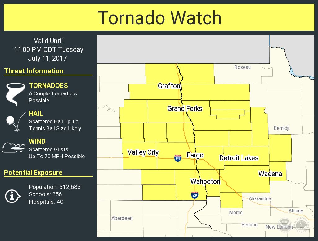
| SPC Tornado Watch area | Estimated Storm Total Rainfall |
 |
Media use of NWS Web News Stories is encouraged! Please acknowledge the NWS as the source of any news information accessed from this site. |
|

