Overview
A strong low pressure system brought light snow and long-lived strong winds to eastern North Dakota and northwest Minnesota beginning the evening of Monday, March 6, 2017 and continuing into the early morning hours of Wednesday, March 8, 2017. Although this system brought generally light snow accumulations to the area, the long period of strong winds allowed for blizzard conditions to persist across portions of the Devils Lake basin throughout much of Tuesday, March 9, 2017. Reduced visibilities were also experienced for brief periods across the northern Red River Valley and into northwest Minnesota on Tuesday as quick bouts of snow easily blew around in 50-60 mph wind gusts.
Wind:
...Graphical Depiction of Highest Wind Gusts March 7-8, 2017......Highest Wind Reports for March 7-8, 2017... Location Speed Time/Date Gwinner ND (APT) 66 MPH 0415 PM 03/07 Devils Lake ND (APT) 64 MPH 1129 AM 03/07 Fargo ND (APT) 62 MPH 0537 PM 03/07 Rothsay MN (DOT) 62 MPH 0540 PM 03/07 Cooperstown ND (APT) 62 MPH 0235 PM 03/07 Wahpeton ND (APT) 61 MPH 0615 PM 03/07 Grafton ND (APT) 61 MPH 0855 PM 03/07 Grand Forks ND (APT) 61 MPH 0511 PM 03/07 Park Rapids MN (APT) 61 MPH 1236 AM 03/08 Mahnomen MN (APT) 60 MPH 0715 PM 03/07 E Grand Forks MN (DOT) 59 MPH 0505 PM 03/07 Grand Forks ND (AFB) 59 MPH 0420 PM 03/07 Dilworth MN (DOT) 58 MPH 0340 AM 03/08 Tenney MN (DOT) 58 MPH 0650 PM 03/07 Staples MN (APT) 58 MPH 1153 PM 03/07 Mcleod ND 3 N 58 MPH 1049 PM 03/07 Lake Park MN (DOT) 57 MPH 1120 PM 03/07 Brooks MN (DOT) 57 MPH 0635 PM 03/07 Mahnomen MN (DOT) 56 MPH 1035 PM 03/07 Hendrum MN (DOT) 56 MPH 0926 AM 03/07 Thief R Falls MN (APT) 56 MPH 0426 PM 03/07 Elbow Lake MN (APT) 56 MPH 0319 PM 03/07 Crookston MN (APT) 55 MPH 1214 AM 03/08 Ottertail MN (DOT) 55 MPH 0435 AM 03/08 Walhalla ND (APT) 54 MPH 0915 PM 03/07 Fergus Falls MN (APT) 54 MPH 0634 PM 03/07 Detroit Lakes MN (DNR) 53 MPH 0320 AM 03/08 Moorhead MN (APT) 53 MPH 1034 PM 03/07 Donaldson MN (DOT) 53 MPH 0710 PM 03/07 Verndale MN (DOT) 53 MPH 1135 PM 03/07 Fosston MN (APT) 52 MPH 0933 PM 03/07 Gatzke MN 2 ENE 52 MPH 0450 PM 03/07 Detroit Lakes MN (APT) 51 MPH 1133 PM 03/07 Badger MN (DOT) 50 MPH 0131 PM 03/07 Wadena MN (APT) 49 MPH 1135 PM 03/07 Flag Island MN 49 MPH 0413 PM 03/07 Hallock MN (APT) 49 MPH 0854 PM 03/07 Karlstad MN (DNR) 49 MPH 0506 PM 03/07 Gatzke MN 9 SW (DNR) 48 MPH 0920 PM 03/07 Baudette MN (APT) 48 MPH 0227 PM 03/07 St Vincent MN (DOT) 48 MPH 0915 AM 03/07 Roseau MN (DNR) 48 MPH 0208 PM 03/07 Waskish MN (APT) 48 MPH 0352 PM 03/07 Bemidji MN (APT) 47 MPH 1253 AM 03/08 Chamberlain MN (DOT) 47 MPH 0735 PM 03/07 Warroad MN (APT) 46 MPH 0134 PM 03/07 Ponsford MN 10 N 45 MPH 1203 AM 03/08 Badoura MN (DNR) 45 MPH 0306 AM 03/08 Kelliher MN (DNR) 45 MPH 0607 PM 03/07 Roseau MN (APT) 45 MPH 0534 PM 03/07 Observations are collected from a variety of sources with varying equipment and exposures. Not all data listed are considered official.
...Wind Damage Reports for March 7-8, 2017...

..TIME...   ...EVENT...      ...CITY LOCATION...     ...LAT.LON...
..DATE...   ....MAG....      ..COUNTY LOCATION..ST.. ...SOURCE....
            ..REMARKS..

1030 AM     NON-TSTM WND DMG 5 S FINLEY              47.44N 97.84W
03/07/2017                   STEELE             ND   PUBLIC

            SEMI TRUCK BLOW OFF ND HIGHWAY 32 SOUTH OF FINLEY.

1100 AM     NON-TSTM WND DMG HILLSBORO               47.40N 97.06W
03/07/2017                   TRAILL             ND   PUBLIC

            A SEMI TRUCK WAS BLOWN OFF OF INTERSTATE 29. TIME
            ESTIMATED, NOT EXACT.

1100 AM     NON-TSTM WND DMG DRAYTON                 48.56N 97.18W
03/07/2017                   PEMBINA            ND   PUBLIC

            A SEMI TRUCK WAS BLOWN OFF OF INTERSTATE 29. TIME
            ESTIMATED, NOT EXACT.

1117 AM     NON-TSTM WND DMG MOORHEAD                46.86N 96.76W
03/07/2017                   CLAY               MN   PUBLIC

            TRAFFIC SIGNALS IN THE CITY OF MOORHEAD DAMAGED AND BLOWN
            OVER.

0500 PM     NON-TSTM WND DMG FARGO                   46.88N 96.82W
03/07/2017                   CASS               ND   PUBLIC

            A METAL LIGHT WAS BLOWN DOWN AT THE VA IN NORTH FARGO.

0700 PM     NON-TSTM WND DMG GRAND FORKS             47.92N 97.07W
03/07/2017                   GRAND FORKS        ND   PUBLIC

            A PORTION OF THE ROOF OF AN RV REPAIR BUSINESS WAS BLOWN
            OFF. TIME IS ESTIMATED, NOT EXACT.

0700 PM     NON-TSTM WND DMG 1 S LARIMORE            47.89N 97.63W
03/07/2017                   GRAND FORKS        ND   PUBLIC

            A SEMI TRUCK WAS BLOWN OFF ND HIGHWAY 18. TIME ESTIMATED,
            NOT EXACT.
Snow:
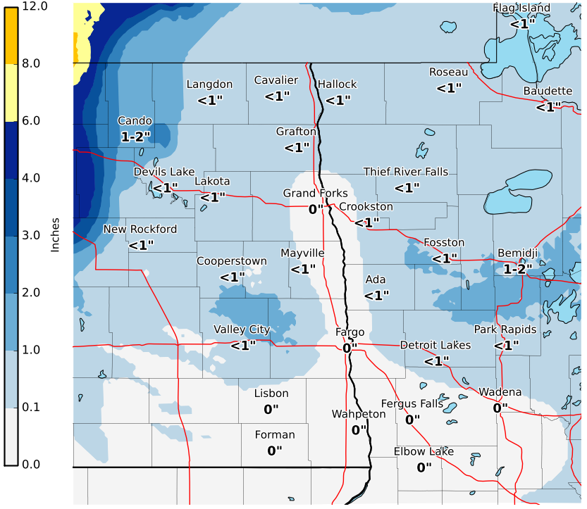
Areas of snowfall accompanied the strong low pressure system on and off from the evening of Monday, March 6, 2017 through the early morning hours of Wednesday, March 8, 2017. The graphic below depicts estimated snowfall amounts provided by trained observers, spotters, and the general public. Snowfall amounts for this event were extremely difficult to measure due to the strong winds and more than likely do not represent exact totals.
...Estimated Snowfall Totals March 6-8, 2017...
Pressure:
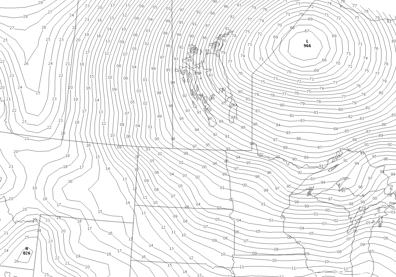
The mean sea level pressure (MSLP) measured with this strong system rivaled the record for lowest pressure recorded in the area for the month of March. The Fargo Airport measured a reading of 980.4 mb as the center of the low moved across eastern North Dakota on Monday, March 7, 2017. The current record for the month of March still stands at 979.3 mb which was recorded on March 15, 1920. As this system tracked to the northeast on Tuesday, the recorded pressure dropped to near 966 mb as it entered western Ontario.
Below is the MSLP plot at 5 pm on Tuesday, March 7, 2017:
Radar:
 |
 |
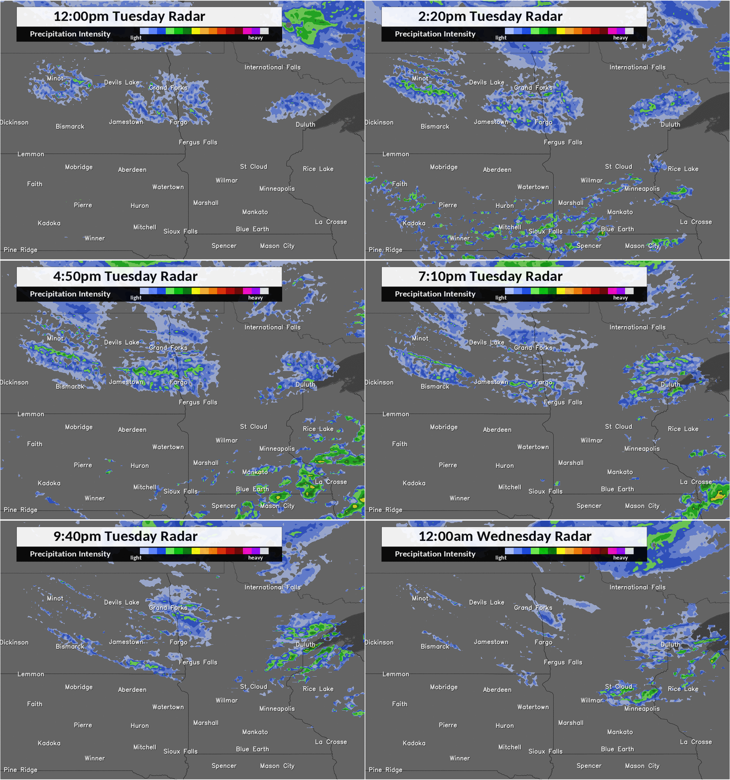 |
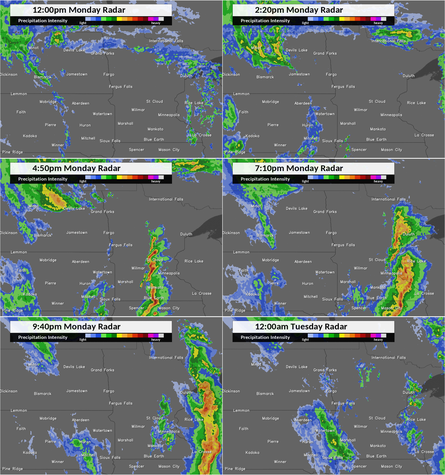
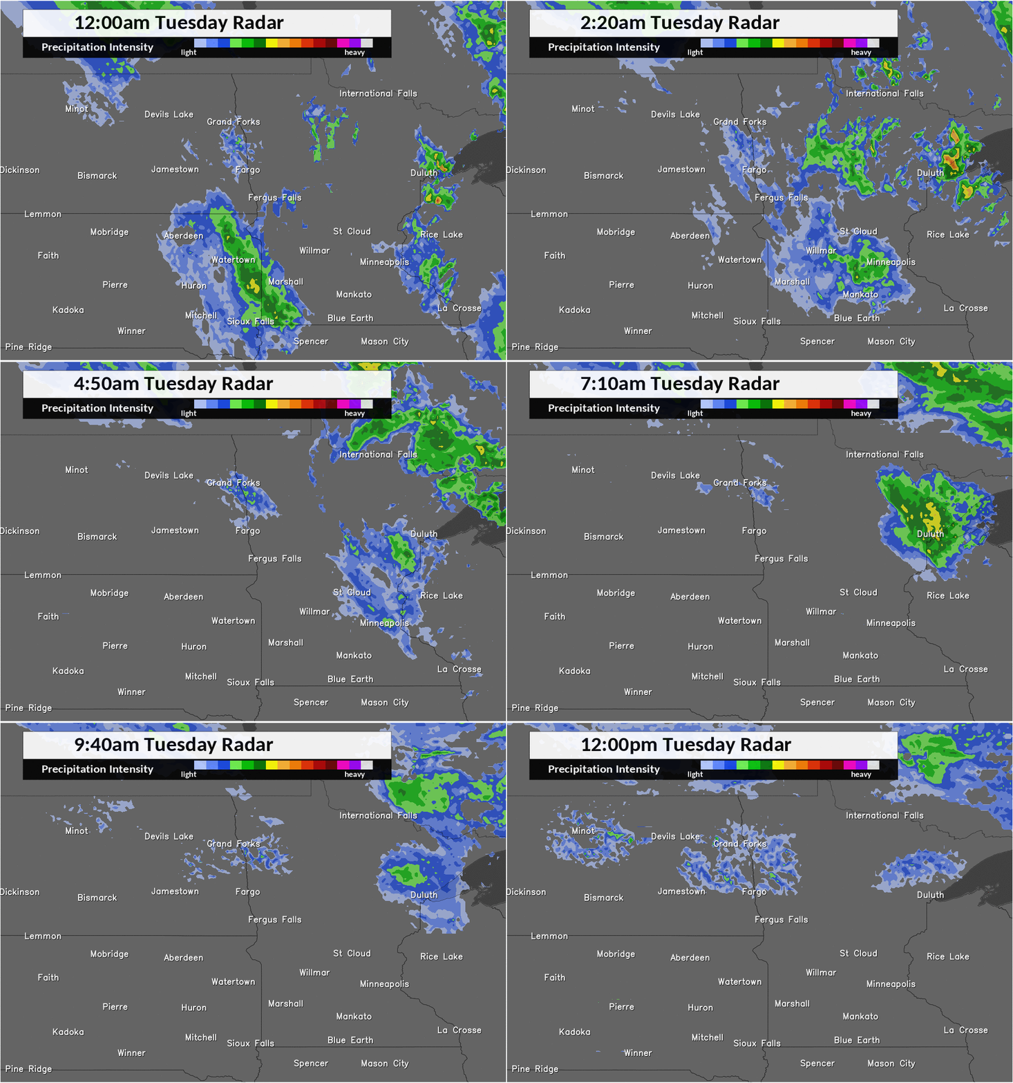
| 12 pm Monday to 12 am Tuesday | 12 am Tuesday to 12 pm Tuesday | 12 pm Tuesday to 12 am Wednesday |
 |
Media use of NWS Web News Stories is encouraged! Please acknowledge the NWS as the source of any news information accessed from this site. |
 |