Overview
Thunderstorms on Sunday, August 28, 2016 brought strong winds and large hail to the region once again. Additionally, a large, slow moving supercell produced at least two tornadoes across portions of Polk and Norman counties in northwest Minnesota. Excessive rainfall also fell across areas that saw heavy rains the day previous to this event, resulting in some flash flooding. Below is a preliminary summary of the event.Tornadoes:
|
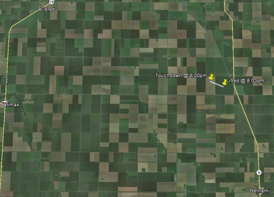
Tornado - Hammond Township
Track Map 
Photo taken near Thompson, ND looking east southeast toward Beltrami, MN Credit: Jeff Makowski
|
||||||||||||||||
|
Tornado - Northwest of Gary, MN
Track Map 
Picture multi-vortex tornado from Brandon Copic Northwest Gary, MN |
||||||||||||||||
The Enhanced Fujita (EF) Scale classifies tornadoes into the following categories:
| EF0 Weak 65-85 mph |
EF1 Moderate 86-110 mph |
EF2 Significant 111-135 mph |
EF3 Severe 136-165 mph |
EF4 Extreme 166-200 mph |
EF5 Catastrophic 200+ mph |
 |
|||||
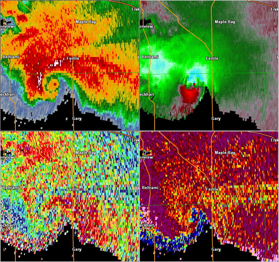
Radar:
Close up radar imagery of the Polk/Norman county supercell from Sunday evening August 28th.
 |
|
| Approximately a one hour radar loop of the slow moving supercell which produced at least two tornadoes in Polk and Norman Counties Sunday evening. | 4 Panel display showing the Classic Supercellular characteristics with a hook in the reflectivity image (top left), tight velocity couplet (top right) Bottom right shows the decreased values in the CC (correlation coefficient). |
Storm Reports:
PRELIMINARY LOCAL STORM REPORT...SUMMARY
NATIONAL WEATHER SERVICE EASTERN ND/GRAND FORKS ND
234 PM CDT TUE AUG 30 2016

..TIME...   ...EVENT...      ...CITY LOCATION...     ...LAT.LON...
..DATE...   ....MAG....      ..COUNTY LOCATION..ST.. ...SOURCE....
            ..REMARKS..

0625 PM     HAIL             3 NE HALMA              48.69N 96.55W
08/28/2016  E1.00 INCH       KITTSON            MN   PUBLIC

0802 PM     TORNADO          2 WSW GREENVIEW         47.61N 96.60W
08/28/2016  F0               POLK               MN   PUBLIC

            TOUCHDOWN. OBSERVED 6E OF NIELSVILLE MN...LOOKING
            NORTHEAST. ROPE TORNADO OCCURRED OVER OPEN COUNTRY IN
            HAMMOND TOWNSHIP FROM 800PM TO 803PM WITH A PATH LENGTH
            NEAR 0.75 MILES AND MAX WIDTH OF 100YDS.

0810 PM     TORNADO          4 E BELTRAMI            47.54N 96.44W
08/28/2016                   POLK               MN   TRAINED SPOTTER

            BRIEF TOUCHDOWN

0904 PM     TORNADO          6 NW GARY               47.43N 96.36W
08/28/2016  F2               NORMAN             MN   LAW ENFORCEMENT

            THIS TORNADO DEVELOPED NEAR THE POLK/NORMAN COUNTY LINE
            IN NORTHERN SPRING CREEK TOWNSHIP. IT INTERMITTENTLY
            TRAVELED SOUTH SOUTHEASTWARD TO JUST NORTHWEST OF GARY
            MN, EXHIBITING MULTIPLE VORTICES AT TIMES BASED ON
            EYEWITNESS REPORTS. HUNDREDS OF TREES WERE UPROOTED,
            SNAPPED, OR DAMAGED ALONG THE TRACK. A BARN WAS
            COMPLETELY DESTROYED AT ONE FARMSTEAD.

0911 PM     TORNADO          3 W FLAMING             47.46N 96.33W
08/28/2016                   NORMAN             MN   PUBLIC

            OBSERVED BETWEEN GARY AND FERTILE LOOKING NORTHWEST.

0937 PM     HAIL             FERTILE                 47.53N 96.29W
08/28/2016  M1.00 INCH       POLK               MN   911 CALL CENTER

0953 PM     HAIL             FERTILE                 47.53N 96.29W
08/28/2016  M1.00 INCH       POLK               MN   TRAINED SPOTTER

            ALSO 60 MPH WIND

0340 AM     HAIL             PARKERS PRAIRIE         46.15N 95.33W
08/29/2016  E1.75 INCH       OTTER TAIL         MN   TRAINED SPOTTER

            HAIL MOSTLY PEA AND DIME SIZE, BUT A FEW GOLFBALLS THROWN
            IN.
Rain Reports:
Below is a 24-hour radar rainfall estimate of the event ending at 12 PM on Monday, August 29th. The following graphic is zoomed into the Polk, Norman, and Mahnomen county areas where radar estimated up to six inches of rainfall was received. These amounts are in addition to the rainfall received on Saturday, August 27th. The graphics are then followed by actual rain gauge reports from across the area in text format.
Public Information Statement
National Weather Service Grand Forks ND
337 PM CDT Mon Aug 29 2016

...Rainfall Reports...

Location                     Amount    Time/Date       Lat/Lon
Fertile MN 3 WSW  (Sandhill  5.85 in   0245 PM 08/29   47.51N/96.34W
Fertile MN                   5.25 in   0505 AM 08/29   47.53N/96.28W
Twin Valley MN               3.95 in   0800 AM 08/29   47.26N/96.26W
Westbury MN 3 ESE            3.27 in   0700 AM 08/29   46.89N/95.84W
Mahnomen MN 1 SE (Wild Rice  2.13 in   0245 PM 08/29   47.31N/95.95W
Baudette MN 3 S (DNR)        2.07 in   0306 PM 08/29   48.67N/94.62W
Waskish MN 4 NE (Tamarac R)  1.96 in   0230 PM 08/29   48.18N/94.51W
Kelliher MN (DNR)            1.95 in   0307 PM 08/29   47.94N/94.45W
Laporte MN 2 WNW             1.86 in   0700 AM 08/29   47.24N/94.81W
Detroit Lakes MN (DNR)       1.83 in   0320 PM 08/29   46.85N/95.85W
Deer Creek MN 1 W            1.76 in   0641 AM 08/29   46.38N/95.36W
Deer Creek MN 0.0 SW         1.60 in   0800 AM 08/29   46.39N/95.32W
Waskish MN (AP)              1.58 in   0652 AM 08/29   48.15N/94.53W
Hoffman MN 3 S               1.47 in   0700 AM 08/29   45.78N/95.78W
New York Mills MN            1.44 in   0730 AM 08/29   46.51N/95.38W
Sebeka MN                    1.40 in   0736 AM 08/29   46.63N/95.08W
Baudette MN (AP)             1.29 in   0653 AM 08/29   48.72N/94.61W
Maple Bay MN 5 ESE           1.27 in   0700 AM 08/29   47.59N/96.13W
Clementson MN (Rapid R)      1.26 in   0300 PM 08/29   48.69N/94.43W
Wadena MN 13 E (Leaf R)      1.18 in   0300 PM 08/29   46.46N/94.84W
Pennington MN 2 S (Knutson D 1.17 in   0300 PM 08/29   47.45N/94.48W
Ada MN                       1.15 in   0705 AM 08/29   47.30N/96.52W
Itasca MN (DNR)              1.12 in   0307 PM 08/29   47.24N/95.19W
Bagley MN 23 S (Long Lost Lk 1.08 in   0700 AM 08/29   47.20N/95.42W
Menahga MN                   1.01 in   0600 AM 08/29   46.76N/95.10W
Ponsford MN 10 N             1.00 in   0318 PM 08/29   47.11N/95.41W
Menahga MN 1 W               1.00 in   0700 AM 08/29   46.75N/95.14W

Observations are collected from a variety of sources with varying
equipment and exposures. Not all data listed are considered official.
 |
Media use of NWS Web News Stories is encouraged! Please acknowledge the NWS as the source of any news information accessed from this site. |
 |