Temperatures surged to record levels across much of the area on Sunday afternoon immediately in advance of a strong cold front. This cold front was associated with a strong upper level low pressure system that was moving southeastward from Canada. A period of very gusty winds developed late Sunday afternoon as the cold front passed through the region, with a few areas from the Red River Valley westward reporting wind gusts to 60 mph. In addition, several fires were reported across the region, aided by the very gusty winds, and warm and dry conditions. Blowing dust and dirt led to reduced visibility in some areas as the surge of gusty winds moved through.
A more prolonged period of gusty winds developed late Sunday Night into Monday as another cold front swept through the region and the large upper level low pressure began to move east from the area. Much cooler air and rain showers accompanied these winds, with many locations over 40 degrees cooler on Monday afternoon compared with Sunday afternoon.
Images (click for larger images)
|
|
|
 |
 |
|
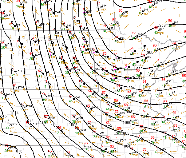
Surface observations around 4 pm Sunday, October 11 as the cold front was approaching the Red River Valley. Temperatures were warmest around this time. |
Visible satellite image around 5 pm on Sunday, October 11 showing blowing dust/dirt behind the cold front and fire plumes, with clouds farther west. | Water vapor satellite image from early October 12 showing the well-developed upper level low pressure system over the area. | Surface observations around 7 am on Monday, October 12 during time period of strong winds across eastern North Dakota behind the surface low pressure system. |
Record Heat
All three local climate sites set record high temperatures on Sunday by sizeable margins.
At both Grand Forks locations, Sunday was the second day in a row of record high temperatures, with the Grand Forks Airport setting a record high of 85 F on Saturday and NWS Grand Forks tying a record of 86 F set back in 1936. On Sunday, Grand Forks Airport hit 90 F, eclipsing the old record of 82 F set in 1995, while NWS Grand Forks reached 89 F, well above the previous record of 81 F from 1938.
Fargo reached 97 F on Sunday, surpassing the old record by 12 degrees (85 F in 1943)! Here are a few more stats regarding Sunday's 97 F temperature at Fargo:
Below is a listing of high temperatures from Sunday, October 11.
LOCATION                     TEMP       PROVIDER
FARGO 1 N (AIRPORT)          97 F       ASOS
MOORHEAD 3 E (AIRPORT)       97 F       AWOS
WAHPETON 1 S (AIRPORT)       95 F       AWOS
SABIN 1 ESE (SB BUFFALO RIVE 95 F       COOP
TURTLE RIVER 3 SE            94 F       CWOP
REILE`S ACRES                93 F       AIRNOW
MOORHEAD 2 NNE               93 F       CWOP
BEMIDJI 4 E (MISSISSIPPI R)  92 F       HADS
BEMIDJI 2 WNW (DNR)          92 F       RAWS
MCLEOD 3 N (SHEYENNE GRASLAN 92 F       RAWS
MAHNOMEN 3 SSE (AIRPORT)     91 F       AWOS
BADOURA (DNR)                91 F       RAWS
DETROIT LAKES 2 N (DNR)      91 F       RAWS
WILTON 6 NE                  91 F       CWOP
FERGUS FALLS 3 W (AIRPORT)   91 F       AWOS
FOSSTON 1 NW (AIRPORT)       91 F       AWOS
GWINNER 1 ESE (AIRPORT)      91 F       AWOS
LAKE ITASCA (DNR)            91 F       RAWS
ELBOW LAKE 1 WSW (AIRPORT)   91 F       AWOS
WADENA 3 W (AIRPORT)         90 F       AWOS
VALLEY CITY 1 NW (AIRPORT)   90 F       AWOS
BEMIDJI 2 WNW (AIRPORT)      90 F       AWOS
BAUDETTE 3 S (DNR)           90 F       RAWS
BEMIDJI 13 NNW (LONG LAKE)   90 F       CWOP
DETROIT LAKES 1 WNW (AIRPORT 90 F       AWOS
GRAND FORKS 5 W (AIRPORT)    90 F       ASOS
MENTOR  3 W (GLACIAL RIDGE)  90 F       MESOWEST
KELLIHER 1 W (DNR)           90 F       RAWS
PARK RAPIDS 2 S (AIRPORT)    90 F       ASOS
COOPERSTOWN 2 SE (AIRPORT)   90 F       AWOS
THIEF RIVER FALLS 3 S (AIRPO 90 F       AWOS
WASKISH 0.5 S (AIRPORT)      90 F       AWOS
GRAND FORKS 5 WSW            89 F       CWOP
GRAND FORKS NWS/UND          89 F       COOP
GRAND FORKS AFB              89 F       ASOS
GOODRIDGE  12 NNW            88 F       NOAA
GATZKE 9 SW (DNR)            88 F       RAWS
PONSFORD 10 N (BAD MEDICINE) 88 F       CWOP
BAUDETTE 1 NW (AIRPORT)      88 F       ASOS
CROOKSTON 5 N (AIRPORT)      88 F       AWOS
VINING 5 SE                  88 F       CWOP
STAPLES 1 N (AIRPORT)        88 F       AWOS
KARLSTAD 1 ENE               85 F       RAWS
GRAFTON 2 ESE (AIRPORT)      84 F       AWOS
ROSEAU 2 E (AIRPORT)         84 F       AWOS
ROSEAU 3 SW                  83 F       CWOP
ROSEAU 1  E (DNR)            83 F       RAWS
LANGDON 2 SW (AIRPORT)       82 F       AWOS
HALLOCK 1 S (AIRPORT)        82 F       AWOS
WARROAD 3 NW (AIRPORT)       82 F       AWOS
ROSS (ROSEAU RIVER)          82 F       HADS
FORT TOTTEN (BIA)            80 F       RAWS
HAMPDEN 1 SE (USFW)          80 F       RAWS
CAVALIER 1 SW (AIRPORT)      79 F       AWOS
WALHALLA 1 NE (AIRPORT)      79 F       AWOS
CANDO 2 WSW (AIRPORT)        77 F       AWOS
FLAG ISLAND                  73 F       AWOS
Winds
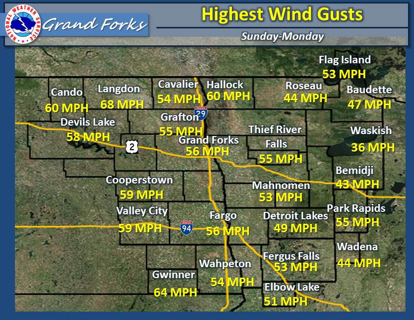
Other Peak Wind Gusts
|
HAMPDEN 1 SE (USFW) |
55 |
|
PONSFORD 10 N (BAD MEDICINE) |
54 |
|
CROOKSTON 5 N (AIRPORT) |
54 |
|
MOORHEAD 3 E (AIRPORT) |
54 |
|
WALHALLA 1 NE (AIRPORT) |
53 |
|
FOSSTON 1 NW (AIRPORT) |
53 |
|
GRAND FORKS AFB |
52 |
|
MCLEOD 3 N (SHEYENNE GRASLANDS) |
52 |
|
DETROIT LAKES 2 N (DNR) |
49 |
|
KARLSTAD 1 ENE |
47 |
|
WARROAD 3 NW (AIRPORT) |
47 |
|
GATZKE 9 SW (DNR) |
46 |
|
FORT TOTTEN (BIA) |
45 |
|
BADOURA (DNR) |
43 |
|
BEMIDJI 2 WNW (DNR) |
43 |
|
ROSEAU 1 E (DNR) |
42 |
|
LAKE ITASCA (DNR) |
40 |


.png)