Overview
A major winter storm affected the region bringing heavy snow to a large portion of North Dakota and adjacent portions of Minnesota. The heavy falling snow combined with strong winds to produce blizzard or near blizzard conditions across parts of the area as well. The greatest snowfall amounts fell from southwest North Dakota into the Jamestown area where 15 to just over 20 inches was common. Most locations across southeast North Dakota received 8 to 12 inches of snow, with values decreasing to the north and east. This snow was very wet, with the snow to liquid ratio generally 10:1 (meaning 10 inches of snow contained about 1 inch of water).
Snow/Ice
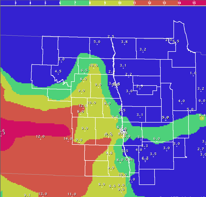
Here is a graphical depiction of snowfall totals, as of 7am April 15th.
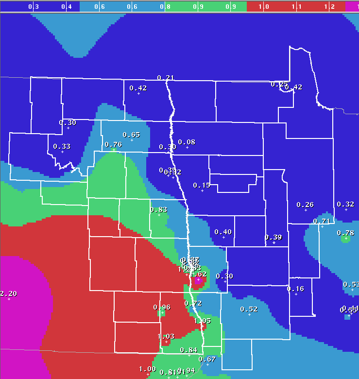
Here is a graphical depiction of the snow liquid equivalent that was new snowfall, as of 7am April 15th.
Here is a list of storm total snowfall reports using data from NWS cooperative observers, COCORAHS observers, and the public.
NORTH DAKOTA
LOCATION (COUNTY): AMT(IN)
COOPERSTOWN (GRIGGS).........................12.0
LANKIN 6E (WALSH)............................11.5
OXBOW (CASS).................................11.5
CHAFFEE (CASS)...............................11.0
LISBON (RANSOM)..............................11.0
WEST FARGO (CASS)............................11.0
FARGO (KVLY-TV) (CASS).......................10.8
TOWER CITY (CASS)............................10.0
FINLEY (STEELE)..............................10.0
MCLEOD (RICHLAND).............................9.8
DURBIN (CASS).................................9.5
FARGO 1ESE (CASS).............................9.4
LIDGERWOOD (RICHLAND).........................9.3
FARGO AIRPORT/CLIMATE SITE (CASS).............9.1
GRANDIN 3SW (CASS)............................9.0
MCVILLE (NELSON)..............................9.0
VALLEY CITY 2NW (BARNES)......................9.0
MAYVILLE (TRAILL).............................9.0
LITCHVILLE (BARNES)...........................9.0
WEST FARGO 4SSE (CASS)........................8.7
HARWOOD (CASS)................................8.5
FARGO 3NE (CASS)..............................8.5
MICHIGAN UCOOP (NELSON).......................8.0
MOORETON 1 S (RICHLAND).......................8.0
HANNAFORD (GRIGGS)............................8.0
HATTON 6 NE (GRAND FORKS).....................7.0
WAHPETON (RICHLAND)...........................7.0
LANKIN 9SW (WALSH)............................6.5
ABERCROMBIE (RICHLAND)........................6.0
FRAZEE (BECKER)...............................6.0
GRAND FORKS 1SW (GRAND FORKS).................5.8
CAVALIER 12 NW (PEMBINA)......................5.4
PENN 6SE (RAMSEY).............................5.1
CAVALIER (PEMBINA)............................5.0
TOLNA (NELSON)................................5.0
PEMBINA (PEMBINA).............................4.5
STARKWEATHER (RAMSEY).........................4.0
DEVILS LAKE (RAMSEY)..........................4.0
GRAND FORKS NWS (GRAND FORKS).................3.8
OSLO 3WNW (WALSH).............................2.4
MINNESOTA
LOCATION (COUNTY): AMT(IN) REPORTS
MOORHEAD (OFFICIAL CO-OP) (CLAY)..............9.1
GEORGETOWN (CLAY).............................8.3
PARK RAPIDS 4 N (HUBBARD).....................7.2
BRECKENRIDGE 3SE (WILKIN).....................6.9
ITASCA U OF M (CLEARWATER)....................6.3
ROOSEVELT 5N (LAKE OF THE WOODS)..............6.0
PARK RAPIDS (HUBBARD).........................6.0
SABIN (CLAY)..................................5.9
LONG LOST LAKE (CLEARWATER)...................5.5
HALSTAD (NORMAN)..............................5.5
EAST GRAND FORKS (POLK).......................5.5
FERTILE (POLK)................................5.5
ROSEAU (ROSEAU)...............................5.3
ELBOW LAKE VILLAGE 8ENE (CLEARWATER)..........5.0
PELICAN RAPIDS 6E (OTTER TAIL)................5.0
LANCASTER (KITTSON)...........................4.6
LAKE PARK 6S (BECKER).........................4.6
WADENA (WADENA)...............................4.5
ROTHSAY (WILKIN)..............................4.5
UNDERWOOD 8NNE (OTTER TAIL)...................4.5
WARROAD 4 W (ROSEAU)..........................4.5
BEMIDJI (BELTRAMI)............................4.5
FERGUS FALLS 1NNE (OTTER TAIL)................4.2
HAWLEY 9.1 SSE (CLAY).........................4.2
FERGUS FALLS 1E (OTTER TAIL)..................4.0
CROOKSTON (POLK)..............................4.0
SEBEKA (WADENA)...............................3.8
BATTLE LAKE (OTTER TAIL)......................3.5
PELICAN RAPIDS (OTTER TAIL)...................3.3
GREENBUSH (ROSEAU)............................3.2
TWIN VALLEY (NORMAN)..........................3.1
ARGYLE (MARSHALL).............................3.1
CAMP NORRIS DNR (BELTRAMI)....................3.0
NEW YORK MILLS (OTTER TAIL)...................3.0
NORRIS CAMP DNR (LAKE OF THE WOODS)...........3.0
WARROAD (ROSEAU)..............................2.7
RED LAKE FALLS (RED LAKE).....................2.5
OTTERTAIL (OTTER TAIL)........................2.5
WARREN 7SE (POLK).............................2.2


