Overview
During the June 26th and 27th time period, a series of thunderstorm complexes moved across the Devils Lake, Red River Valley and Minnesota Lakes Country. Excessive rainfalls were generally spotty, but even a little rainfall with the currently saturated soils is a bit much. Where the heavier rains fell, there have been rises on area rivers, creeks and streams. Generally speaking, the heaviest rainfalls were over the lower Devils Lake Basin, the west central Minnesota Lakes Country as well as east central and southeast North Dakota. RADAR estimates suggest over 3 inches of rain fell in a few locations, with observations indicating that 1.5 to 2.5 inches were common across the region.
The good news is the pattern appears to be slowly shifting to a warmer regime through much of this week. On balance the upcoming week looks like we'll experience less rainfall, but typical of summer there is always a threat at one time or another for rain.
For observations and forecasts of area rivers please visit the AHPS web page by clicking here.
Below is an image of 3 day rain totals from 7am Friday June 24th through 7am Monday June 27th.
Rain Total Reports
Below is a table of the total precipitation.
...3-DAY RAINFALL ROUND-UP...
THE FOLLOWING ARE RAIN AMOUNTS FOR THE PREVIOUS 24-HOURS
AS MEASURED IN THE MORNING BY NWS COOPERATIVE OBSERVERS.
OBSERVATIONS ARE USUALLY TAKENAT7 AM.
24-HOUR RAINFALL REPORTS:
***************** MONDAY (06/27/11) **************
NORTH DAKOTA RAIN
LOCATION (COUNTY): FALL (IN)
GRAND FORKS 1SW (GRAND FORKS).................1.77
HARWOOD (CASS)................................1.39
GRAND FORKS NWS (GRAND FORKS).................1.33
NDAWN AT WYNDMERE (RICHLAND)..................1.16
NDAWN AT DAZEY (BARNES).......................0.97
NDAWN AT PILLSBURY (BARNES)...................0.76
VALLEY CITY 2NW (BARNES)......................0.74
LIDGERWOOD (RICHLAND).........................0.71
SHEYENNE 7ESE (EDDY)..........................0.68
WEST FARGO 4SSE (CASS)........................0.66
MAPLETON (CASS)...............................0.65
FARGO 1ESE (CASS).............................0.65
OSLO 3WNW (WALSH).............................0.65
FARGO 2SE (CASS)..............................0.61
FARGO 3NE (CASS)..............................0.56
ASOS AT GRAND FORKS AFB (GRAND FORKS).........0.55
ASOS AT FARGO AIRPORT (CASS)..................0.53
NDAWN AT WAHPETON (RICHLAND)..................0.52
FARGO 5NW (CASS)..............................0.50
ASOS AT GRAND FORKS AP (GRAND FORKS)..........0.48
MICHIGAN UCOOP (NELSON).......................0.48
MAYVILLE (TRAILL).............................0.48
NORTH DAKOTA STATE UNIV (CASS)................0.40
NDAWN AT MICHIGAN 2W (NELSON).................0.39
NDAWN AT GALESBURG (TRAILL)...................0.38
KINDRED (CASS)................................0.36
NEW ROCKFORD 7ESE (EDDY)......................0.32
GRANDIN 3SW (CASS)............................0.31
NDAWN AT MAYVILLE (TRAILL)....................0.27
LANKIN 9SW (WALSH)............................0.23
LANKIN 6E (WALSH).............................0.22
AWOS AT DEVILS LAKE (RAMSEY)..................0.20
NDAWN AT HILLSBORO (TRAILL)...................0.15
CAVALIER (PEMBINA)............................0.14
PEMBINA (PEMBINA).............................0.14
PENN 6SE (RAMSEY).............................0.11
STARKWEATHER (RAMSEY).........................0.11
NDAWN AT CAVALIER (PEMBINA)...................0.10
GRAFTON ARPT (WALSH)..........................0.06
LANGDON EXP FARM (CAVALIER)...................0.04
NDAWN AT BAKER (BENSON).......................0.03
NDAWN AT LANGDON (CAVALIER)...................0.02
NDAWN AT CANDO (TOWNER).......................0.01
MINNESOTA RAIN
LOCATION (COUNTY): FALL (IN)
ASOS AT PARK RAPIDS (HUBBARD).................1.76
ROOSEVELT 5N (LAKE OF THE WOODS)..............1.73
BARNESVILLE (CLAY)............................1.72
AWOS AT DETROIT LAKES (BECKER)................1.65
AWOS AT WARROAD (LAKE OF THE WOODS)...........1.22
SEBEKA (WADENA)...............................0.88
GREENBUSH (ROSEAU)............................0.87
CAMP NORRIS DNR (BELTRAMI)....................0.78
SABIN (CLAY)..................................0.78
ITASCA U OF M (CLEARWATER)....................0.75
LONG LOST LAKE (CLEARWATER)...................0.73
ELBOW LAKE VILLAGE 8ENE (CLEARWATER)..........0.73
NEW YORK MILLS (OTTER TAIL)...................0.72
WARROAD (ROSEAU)..............................0.69
UNDERWOOD 8NNE (OTTER TAIL)...................0.65
MOORHEAD (CLAY)...............................0.63
BRECKENRIDGE (WILKIN).........................0.62
AWOS AT FERGUS FALLS (OTTER TAIL).............0.62
ROTHSAY (WILKIN)..............................0.60
AWOS AT FLAG ISLAND (LAKE OF THE WOODS).......0.58
ASOS AT BAUDETTE (LAKE OF THE WOODS)..........0.51
NDAWN AT PERLEY (NORMAN)......................0.50
BEMIDJI 8NE (BELTRAMI)........................0.46
AWOS AT ELBOW LAKE AWOS (GRANT)...............0.46
AWOS AT ROSEAU (ROSEAU).......................0.40
AWOS AT WADENA (WADENA).......................0.34
AWOS AT FOSSTON (POLK)........................0.31
AWOS AT BEMIDJI (BELTRAMI)....................0.29
ARGYLE (MARSHALL).............................0.21
HALSTAD (NORMAN)..............................0.20
NDAWN AT STEPHEN (MARSHALL)...................0.18
LANCASTER (KITTSON)...........................0.17
HUMBOLT (KITTSON).............................0.16
RED LAKE FALLS (RED LAKE).....................0.13
AWOS AT HALLOCK (KITTSON).....................0.05
AWOS AT THIEF RIVER FALLS (PENNINGTON)........0.04
***************** SUNDAY (06/26/11) **************
NORTH DAKOTA RAIN
LOCATION (COUNTY): FALL (IN)
SHEYENNE 7ESE (EDDY)..........................2.30
NDAWN AT BAKER (BENSON).......................1.40
HARWOOD (CASS)................................1.40
GRAFTON ARPT (WALSH)..........................1.35
VALLEY CITY 2NW (BARNES)......................1.20
NEW ROCKFORD 7ESE (EDDY)......................1.10
NDAWN AT MICHIGAN 2W (NELSON).................1.08
LANKIN 6E (WALSH).............................0.95
NDAWN AT HILLSBORO (TRAILL)...................0.94
DEVILS LAKE KDLR (RAMSEY).....................0.91
MAPLETON (CASS)...............................0.88
MICHIGAN UCOOP (NELSON).......................0.87
NDAWN AT CRARY (RAMSEY).......................0.83
NDAWN AT WYNDMERE (RICHLAND)..................0.82
ASOS AT FARGO AIRPORT (CASS)..................0.76
MAYVILLE (TRAILL).............................0.75
AWOS AT DEVILS LAKE (RAMSEY)..................0.74
NDAWN AT DAZEY (BARNES).......................0.69
LANKIN 9SW (WALSH)............................0.68
VALLEY CITY (BARNES)..........................0.68
OSLO 3WNW (WALSH).............................0.65
NDAWN AT MAYVILLE (TRAILL)....................0.62
FARGO 1ESE (CASS).............................0.59
FARGO 2SE (CASS)..............................0.57
FARGO 5NW (CASS)..............................0.55
WEST FARGO 4SSE (CASS)........................0.54
ASOS AT GRAND FORKS AP (GRAND FORKS)..........0.53
ASOS AT GRAND FORKS AFB (GRAND FORKS).........0.53
GRAND FORKS 1SW (GRAND FORKS).................0.50
NDAWN AT CAVALIER (PEMBINA)...................0.49
GRAND FORKS NWS (GRAND FORKS).................0.49
LANGDON EXP FARM (CAVALIER)...................0.48
NDAWN AT LANGDON (CAVALIER)...................0.44
EDMORE (RAMSEY)...............................0.43
PEMBINA (PEMBINA).............................0.43
STARKWEATHER (RAMSEY).........................0.43
NORTH DAKOTA STATE UNIV (CASS)................0.40
CAVALIER (PEMBINA)............................0.32
NDAWN AT PILLSBURY (BARNES)...................0.32
KINDRED (CASS)................................0.31
NDAWN AT CANDO (TOWNER).......................0.30
NDAWN AT GALESBURG (TRAILL)...................0.24
PENN 6SE (RAMSEY).............................0.06
MINNESOTA RAIN
LOCATION (COUNTY): FALL (IN)
ARGYLE (MARSHALL).............................0.89
RED LAKE FALLS (RED LAKE).....................0.87
NDAWN AT STEPHEN (MARSHALL)...................0.87
HALSTAD (NORMAN)..............................0.70
AWOS AT FOSSTON (POLK)........................0.64
HUMBOLT (KITTSON).............................0.64
NDAWN AT PERLEY (NORMAN)......................0.59
TAMARAC WILDLIFE REFUGE (BECKER)..............0.59
LANCASTER (KITTSON)...........................0.56
MOORHEAD (CLAY)...............................0.55
SABIN (CLAY)..................................0.51
AWOS AT BEMIDJI (BELTRAMI)....................0.48
ASOS AT PARK RAPIDS (HUBBARD).................0.45
AWOS AT HALLOCK (KITTSON).....................0.44
ITASCA U OF M (CLEARWATER)....................0.42
LONG LOST LAKE (CLEARWATER)...................0.41
AWOS AT DETROIT LAKES (BECKER)................0.39
AWOS AT THIEF RIVER FALLS (PENNINGTON)........0.36
BEMIDJI (BELTRAMI)............................0.35
GREENBUSH (ROSEAU)............................0.31
CAMP NORRIS DNR (BELTRAMI)....................0.22
AWOS AT ROSEAU (ROSEAU).......................0.22
WARROAD (ROSEAU)..............................0.21
ROOSEVELT 5N (LAKE OF THE WOODS)..............0.19
AWOS AT WARROAD (LAKE OF THE WOODS)...........0.17
WASKISH (BELTRAMI)............................0.07
AWOS AT FLAG ISLAND (LAKE OF THE WOODS).......0.03
ASOS AT BAUDETTE (LAKE OF THE WOODS)..........0.02
BEMIDJI 8NE (BELTRAMI)........................0.01
ROTHSAY (WILKIN).............................TRACE
***************** SATURDAY (06/25/11) **************
NORTH DAKOTA RAIN
LOCATION (COUNTY): FALL (IN)
HARWOOD (CASS)................................0.10
HAVANA (SARGENT)..............................0.05
FARGO 1ESE (CASS).............................0.05
LIDGERWOOD (RICHLAND).........................0.03
VALLEY CITY (BARNES)..........................0.03
NDAWN AT CAVALIER (PEMBINA)...................0.02
CAVALIER (PEMBINA)............................0.01
NDAWN AT MAYVILLE (TRAILL)....................0.01
WEST FARGO 4SSE (CASS)........................0.01
LANKIN 9SW (WALSH)...........................TRACE
MINNESOTA RAIN
LOCATION (COUNTY): FALL (IN)
ASOS AT PARK RAPIDS (HUBBARD).................0.03
AWOS AT DETROIT LAKES (BECKER)................0.01
ITASCA U OF M (CLEARWATER)....................0.01
LONG LOST LAKE (CLEARWATER)..................TRACE
MOORHEAD (CLAY)..............................TRACE
SELECTED 3 DAY TOTALS FROM COOPERATIVE OBSERVATIONS...RAIN GAGE
AND OTHER DATA SOURCES.
SELECTED 72 HOUR TOTALS RAIN
ENDING AT 7 AM MONDAY JUNE 27 FALL (IN)
SHEYENNE 7ESE 2.98
BUFFALO RIVER NR GEOEOGETOWN 2.89
GRAND FORKS 1SW 2.27
ASOS AT PARK RAPIDS 2.24
RAWS AT DETROIT LAKES 2.16
FELTON DITCH AT CO RD 27 2.15
AWOS AT DETROIT LAKES 2.05
NDAWN AT WYNDMERE 1.98
RAWS AT FT TOTEN-DEVI 1.98
VALLEY CITY 2NW 1.94
ROOSEVELT 5N 1.92
GRAND FORKS NWS 1.82
NDAWN AT DAZEY 1.66
SNAKE RRVER RETENTION POND 1.65
HARWOOD 1.49
NDAWN AT MICHIGAN 2W 1.47
BALDHILL DAM AT LK AS 1.46
NDAWN AT BAKER 1.43
GRAFTON ARPT 1.41
BAUUDETTE 12 S. 1.41
AWOS AT WARROAD 1.39
WARWICK 1.36
COOPERSTOWN 1.35
OSLO 3WNW 1.30
FARGO 1ESE 1.29
ASOS AT FARGO AIRPORT 1.29
LEGEND:
ASOS - AUTOMATED SURFACE OBSERVATION SYSTEM
AWOS - AUTOMATED WEATHER OBSERVATION SYSTEM
NDAWN - NORTH DAKOTA AGRICULTURAL WEATHER NETWORK
RAWS - REMOTE AUTOMATED WEATHER STATION
Estimated Rain Total Map
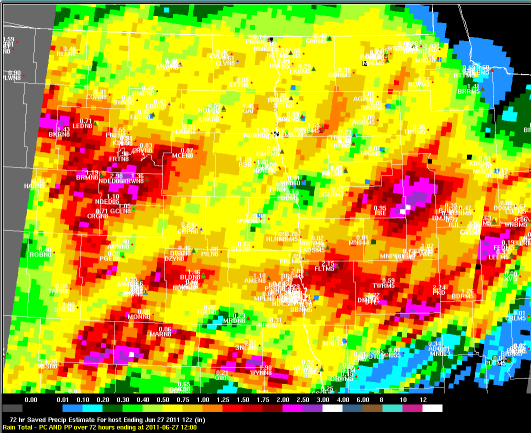
Radar Estimated Rainfall Totals During the Two-Day Period
 |
Media use of NWS Web News Stories is encouraged! Please acknowledge the NWS as the source of any news information accessed from this site. |
|

