Grand Forks, ND
Weather Forecast Office
Overview
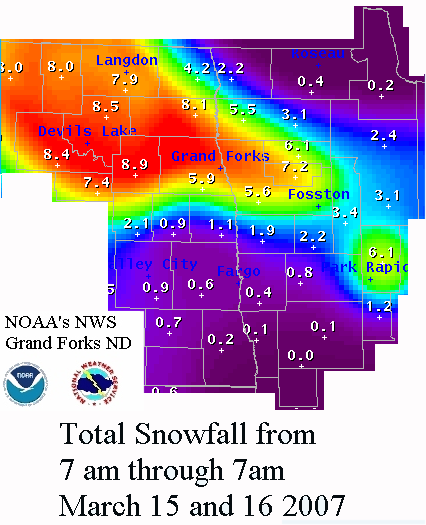
A small yet intense storm system dropped significant snow from the Devils Lake Basin in northeast North Dakota through the central Red River Valley then toward the headwaters of the Mississippi River Valley. A narrow band of 6 to 8 inches fell across this region. See the map below for details.Snow/Ice
Here is a graphical depiction of snowfall totals from March 15-16, 2007.
Storm Reports
THE FOLLOWING IS A LIST OF SNOWFALL ACCUMULATIONS IN INCHES
AS OF 3PM TODAY REPORTED BY COOPERATIVE OBSERVERS...SPOTTERS
AND LAW ENFORCEMENT.

NORTH DAKOTA

CANDO................. 6-8
DEVILS LAKE........... 6
LOMA (12 SW LANGDON).. 5-6
EDMORE................ 5.5
LANGDON............... 5.1
DRAYTON............... 4-5
PETERSBERG............ 4-5
MINTO................. 3-5
PEMBINA............... 3
NEW ROCKFORD.......... 2-3
COOPERSTOWN........... 2

MINNESOTA

WARREN................ 6-7
THIEF RIVER FALLS..... 6
RED LAKE FALLS........ 5
BAGLEY................ 3-4
BEMIDJI............... 3-4
CROOKSTON............. 3-4
HALLOCK............... 3.5
MAHNOMEN.............. 3
ADA................... 2
GREENBUSH............. AROUND 1 INCH

$$

KENNEDY
 |
Media use of NWS Web News Stories is encouraged! Please acknowledge the NWS as the source of any news information accessed from this site. |
|
US Dept of Commerce
National Oceanic and Atmospheric Administration
National Weather Service
Grand Forks, ND
4797 Technology Circle
Grand Forks, ND 58203-0600
701-772-0720
Comments? Questions? Please Contact Us.

