Overview
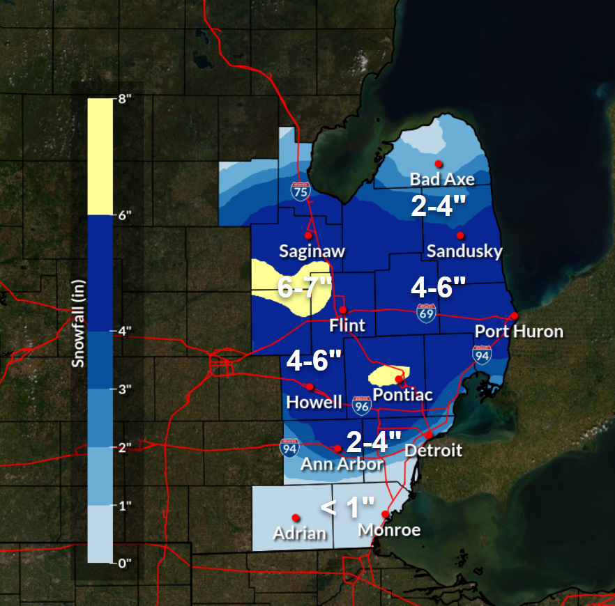
Despite a mild early and mid-March (multiple 70+ degree days), a colder airmass and widespread accumulating snowfall impacted southeast Michigan on Friday, March 22nd. The snow began early in the morning and peaked during the morning commute as the leading edge of elevated warm advection and accompanying frontogenesis lifted northward into the Great Lakes. By noon, snowfall reports were coming in between 1 to 4 inches while radar presentation showed a transition to linear snowbands that were oriented roughly west to east with a gradual northward trajectory. By afternoon, a shallow dry slot worked in to the southern counties and brought an end to any lingering snow for areas south of I-94. Meanwhile, the elevated warm frontal bands continued their northward trekk and eventually settled between I-69 and M-46, further intensifying as a more favorable environment developed aloft. The band eventually congealed into one and produced moderate to heavy snow between the I-69 and M-46 corridors for several hours before pivoting back to the south as a cold front, with additional accumulations of 1 to 2 inches Friday night as the snow re-expanded south. Snow tapered off after midnight local time, with snow accumulations north of roughly I-94 ranging between 3 to 6 inches with some locally higher spots in the banded region.
Snow Totals
Note:  Snowfall totals are from the morning of Friday, March 22nd through Saturday morning, March 23rd.

Public Information Statement...Summary
National Weather Service Detroit/Pontiac MI
621 PM EDT Sat Mar 23 2024

STORM TOTAL SNOW REPORTS

Location                     Amount    Time/Date

...Michigan...

...Bay County...
2 E Bay City                 4.2 in    0839 PM 03/22

...Genesee County...
3 SE Birch Run               5.8 in    0925 PM 03/22
Flint                        5.2 in    1000 PM 03/22

...Huron County...
Sebewaing                    3.0 in    1010 PM 03/22

...Lapeer County...
Otter Lake                   5.0 in    1010 PM 03/22
5 W Lapeer                   3.6 in    1000 PM 03/22

...Midland County...
Midland                      3.0 in    1028 PM 03/22

...Oakland County...
4 E White Lake               6.1 in    1200 AM 03/23
Berkley                      5.0 in    0706 PM 03/22
Troy                         4.9 in    1100 PM 03/22
Farmington Hills             4.8 in    1200 AM 03/23
1 NE Farmington              4.5 in    0740 PM 03/22

...Saginaw County...
3 NW Oakley                  7.0 in    0930 PM 03/22
Burt                         6.5 in    0820 PM 03/22
8 NW Saginaw                 3.6 in    0800 PM 03/22

...Sanilac County...
Deckerville                  4.0 in    1000 PM 03/22

...Shiawassee County...
New Lothrop                  6.8 in    0847 PM 03/22
Owosso                       5.3 in    1000 PM 03/22
Durand                       5.0 in    1015 PM 03/22

...St. Clair County...
Lakeport                     4.6 in    1030 PM 03/22
Observations are collected from a variety of sources with varying
equipment and exposures. We thank all volunteer weather observers
for their dedication. Not all data listed are considered official.
 |
|
Storm Total Snowfall |
Radar
|
|
|
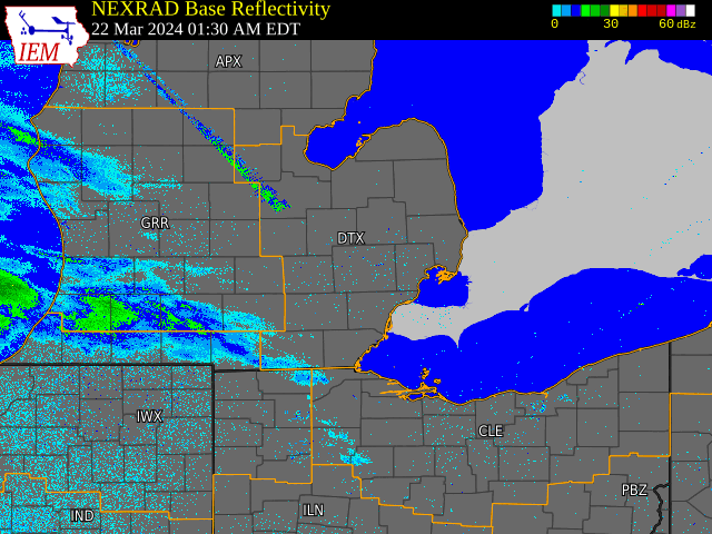
Radar: NEXRAD mosaic base reflectivity radar loop from 130 AM March 22, 2024 through 11:30 PM March 22, 2024.
|
 |
Media use of NWS Web News Stories is encouraged! Please acknowledge the NWS as the source of any news information accessed from this site. |
|