March 20, 2001 marks the 25th Anniversary of the West Bloomfield F4 tornado. This tornado was the last violent tornado (F4 or F5) to strike Southeast Michigan. The tornado touched down at 7:15 pm, March 20, 1976 near Halsted Road between 13 and 14 Mile Roads, along a sharp cold front crossing Michigan. The tornado cut a path (Figure 1) four miles long and 350 yards wide across Oakland County before dissipating near Maple Road between Middlebelt and Inkster Roads. The tornado killed one, injured 55 and produced $50 million (or about $155 million in 2001 dollars) in damage.
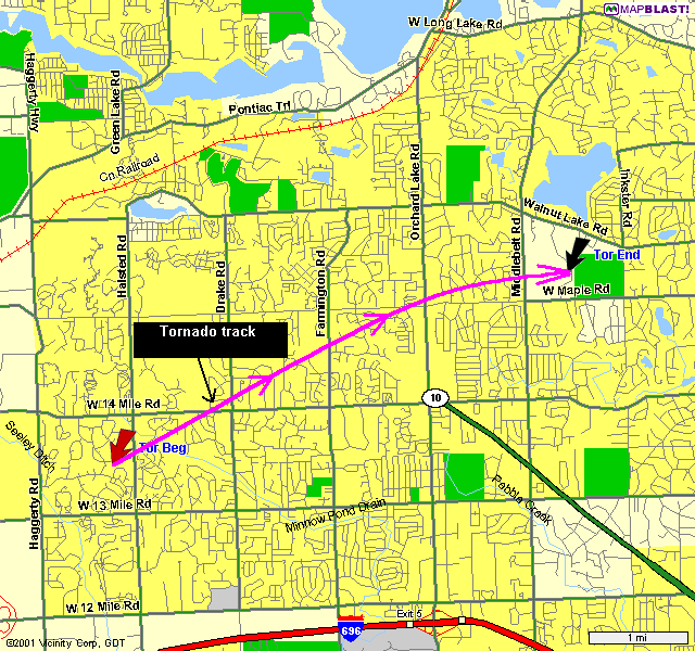 |
| Figure 1. West Bloomfield tornado track. |
Tornado produces death, injuries, and property damage
One death was attributed to the tornado. A fifteen year-old girl riding in a car with three other passengers was killed when the tornado picked the car up near the corner of Maple and Orchard Lake, and hurled it to the north side of Maple Road, crushing the roof and smashing the windows. The other three passengers survived.
F4 tornadoes are devastating tornadoes with wind speeds between 207-260 mph. Tornadoes of this magnitude are capable of leveling well constructed houses, throwing cars, and projecting large missiles. Much of the damage associated with this tornado occurred in a square mile area bounded by Walnut Lake, Orchard Lake, Maple and Middlebelt Roads, near the intersection of Orchard Lake and Maple Roads in West Bloomfield. Scores of homes were damaged, with several dozen destroyed. Many businesses sustained considerable damage, with nearly two dozen businesses in the Old Orchard Shopping Center and Orchard Mall feeling the brunt of the tornado.
Meteorological factors contributing to the tornado development
The tornado developed ahead of a powerful cold front that swept across Michigan during the day and evening. Ahead of the cold front temperatures rose to 67 and 71 at Flint (LCD for Flint) and Detroit (LCD for Detroit) respectively on March 20th. Behind the front, temperatures plunged into the low 20s by the evening of the 21st. South-Southwest winds to 60 mph just 5000 feet above the ground pumped warm, moist air into Michigan providing the fuel for the tornado.
Twenty-seven severe weather events struck Michigan on March 20, 1976. Although the strongest, the West Bloomfield tornado was not the only one to strike Michigan on the 20th. Four other tornadoes struck the state, including an F3 that raced across Macomb County (Figure 2) about 30 minutes after the West Bloomfield tornado. (The Macomb tornado also killed one -- an infant.) In addition to the tornadoes, severe thunderstorms whipped across Genesee, Lapeer, Tuscola, and Shiawassee Counties in Southeast Michigan, and 12 other counties in Lower Michigan.
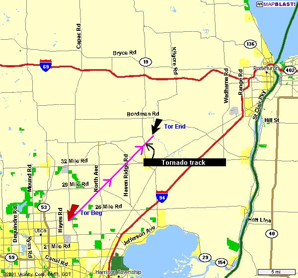 |
| Figure 2. Macomb tornado track. |
Michigan was not alone in witnessing severe weather. The front spawned 63 tornadoes across the Midwest (ex-Michigan), South and East before it moved out into the Atlantic on March 21st. The West Bloomfield tornado was one of three F4's; the others were in Illinois and Indiana.
How prepared is Southeast Michigan today for an F4 or F5 tornado?
Increased scientific understanding of the nature of tornadoes, coupled with technological advances have allowed the National Weather Service to dramatically improve tornado warning capabilities over the last 25 years. For example, the warning did not go out on the West Bloomfield tornado until it touched down. Today, the Weather Service aims to issue warnings before a tornado hits.
National Weather Service Detroit/Pontiac Meteorologist-in-Charge, Dick Wagenmaker points out, "Today we know quite a bit more about how tornadoes form than we did 25 years ago. For example, we now know of the critical importance that boundaries play in producing the severe thunderstorms that produce tornadoes. Here at the Detroit/Pontiac office we pay close attention to where these boundaries will develop during the course of the day. This in turn allows us to get a handle on the potential for tornadic development, the location of the development, and the intensity of the storms." (Typical boundaries of interest to meteorologists in Michigan would be warm and cold fronts as well as lake breezes.)
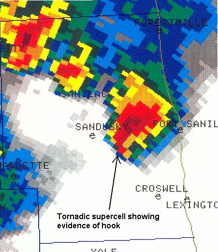
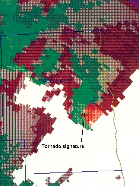
Meteorologists observing the 1976 tornado did so with 1950's era radar. Today Doppler radar technology and sophisticated software allow meteorologists to detect many tornadoes in their development phase before they touchdown. Wagenmaker goes on, "(The) advent of Doppler radar allows meteorologists the ability to better detect tornadoes, especially the F4s and F5s like the the West Bloomfield tornado, now than in 1976." Figures 3a-b, 4 illustrate the value of the Doppler radar over the previous radar.
 |
 |
|
Figure 3a. Example of National Weather Service Doppler radar technology circa 1998 detecting a tornado over Sanilac County. This image depicts radar derived reflectivities of precipitation. The hotter colors (reds and yellows) indicate heavy precipitation; the cool colors (blues and greens) indicate lighter precipitation. |
Figure 3b. Same as Figure 3a, except depicting rotation in the thunderstorm. Wind blowing in (green) toward the radar in White Lake, Oakland County (to the southwest of Sanilac County) right next to wind blowing out (red) is a signature of a tornado. This ability to detect rotation in the storm is one of the key advances in Weather Service radar capability that Doppler technology brings to the forecasting of tornadoes. |
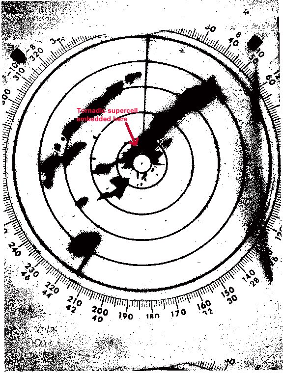 |
| Figure 4. National Weather Service WSR-57 radar image from Detroit Metro Airport, March 20, 1976 at 7:15 pm -- just about touchdown. Some of the clarity in the picture has been lost due to reproductive techniques. However, it is clear that the ability to discern a tornado in this image is many times more difficult than in Figs 3a-b. This is the improvement Wagenmaker is alluding to above. |
Improved technological and scientific understanding of tornadoes are two key tools in providing residents of Southeast Michigan improved warning services. A third essential element is the National Weather Service severe weather spotter program. In 1976, a couple of hundred trained weather observers watched the skies over Southeast Michigan for any signs of severe weather. Now, National Weather Service Detroit/Pontiac Warning Coordination Meteorologist Darin Figurskey notes, "There are about 2,000 trained weather spotters in Southeast Michigan, or 10 times the number available in 1976."
Is Southeast Michigan "due" for a violent tornado?
Over the last 50 years (the "modern era" in tornado record keeping), Southeast Michigan has experience 10 violent tornadoes. These are listed below chronologically.
|
Location (County) |
Date |
F-Scale |
|
St. Clair |
05/21/1953 |
F4 |
|
Monroe |
06/08/1953 |
F4 |
|
Genesee |
06/08/1953 |
F5 |
|
Lapeer |
06/08/1953 |
F4 |
|
Genesee |
05/12/1956 |
F4 |
|
Wayne |
05/12/1956 |
F4 |
|
Livingston |
07/04/1957 |
F4 |
|
Macomb |
05/08/1964 |
F4 |
|
Monroe |
04/11/1965 |
F4 |
|
Oakland |
03/20/1976 |
F4 |
The West Bloomfield tornado was the last violent tornado to strike Southeast Michigan. Simple arithmetic would suggest a violent tornado once about every five years. There is, of course, no way of telling, at this point, when the next tornado will strike the region. That is why the National Weather Service urges everyone to be prepared for a tornado. Here are some simple rules to follow before the storm and during a tornado to protect yourself and loved ones:
Before the Storm:
Develop a plan for you and your family for home, work, school and when outdoors
Have frequent drills.
Know the county in which you live or are visiting, and keep a highway map nearby to follow storm movement from weather bulletins.
Have a NOAA Weather Radio with a warning alarm tone and battery back-up to receive warnings.
Listen to radio and television for information.
If planning a trip outdoors, listen to the latest forecasts and take necessary action if threatening weather is possible.
If a Warning is issued or if threatening weather approaches:
In a home or building, move to a pre-designated shelter, such as a basement.
If an underground shelter is not available, move to an interior room or hallway on the lowest floor and get under a sturdy piece of furniture.
Stay away from windows.
Get out of automobiles.
Do not try to outrun a tornado in your car; instead, leave it immediately.
Mobile homes, even if tied down, offer little protection from tornadoes and should be abandoned.
Occasionally, tornadoes develop so rapidly that advance warning is not possible. Remain alert for signs of an approaching tornado. Flying debris from tornadoes causes most deaths and injuries.
More details available from the web
More information is available on tornadoes from the National Weather Service.
Sources
Detroit News, Oakland Press, National Weather Service-Detroit/Pontiac, National Climatic Data Center.

