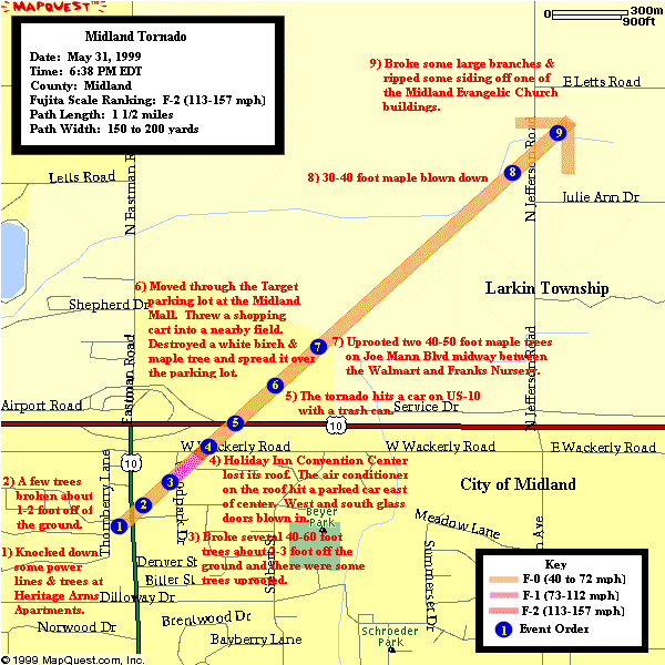
Between 9:40 PM on May 31st and 2:30 AM on June 1st, Jeff Boyne (meteorologist) from the National Weather Service in White Lake, Michigan investigated the tornado damage in the northeast corner of the city of Midland and Sections 33 and 34 in Larkin Township in the Midland County. From this damage survey, the Midland tornado was ranked an F-2 (winds 113 to 157 mph) on the Fujita scale (this scale ranks tornadoes by the damage they cause and runs from F-0 to F-5 where F-0 is the weakest and F-5 is the strongest). While on the ground, the tornado produced mainly F-0 (winds 40 to 72 mph) and F-1 (winds 73 to 112 mph); however, it did briefly intensify to an F-2 as it tore off the roof of the Holiday Inn Convention Center at 1500 West Wackerly Street in northeast Midland.
From Midland County 911 phone records, the tornado touched down at 6:38 PM on May 31st at the Heritage Arms Apartments on the west side of Eastman Avenue north of Dilloway Street in the northeast corner of the city of Midland. At this location, the tornado knocked down some power lines and a few trees. This damage was consistent with an F-0 tornado.
The tornado moved northeast crossing both Eastman Avenue and Harcrest Street. There were a few trees broken about a foot to 2 feet off of the ground. The tornado also hit a few buildings, but it was too weak to do any damage. As was the case with Heritage Arms Apartments, the damage was consistent with an F-0 tornado.
Continuing to move northeast on Woodpark Street, the tornado broke several large trees (40 to 60 feet tall) about 2 to 3 foot off the ground and there were some trees uprooted. The trees were lying in a variety of directions. Some of the houses had windows blown out, and rain gutters and siding removed. Due to the power lines being run underground in this area, there were no power disruptions in this area. The majority of the damage in this area was rated as an F-1 tornado.
The tornado continued northeast crossing West Wackerly. There it struck the Holiday Inn Convention Center. It blew off the roof of the convention center and blew in the west and south glass doors. The air conditioner from the roof was thrown to the east where it caused some damage to a parked car. As stated earlier, the damage to the Holiday Inn was rated as an F-2.
The tornado then moved across US-10. There it moved through the Target parking lot which is located in the southeast corner of the midland mall. Pieces of Holiday Inn roof were found in the mall parking lot. The Target shopping cart holder was thrown into a nearby field to the east. Also, the tornado destroyed a maple and white birch tree. Pieces of these trees were scattered across the parking lot. The damage in this area was rated an F-0.
The tornado moved across Joe Mann Boulevard midway between the Walmart and franks nursery. There it uprooted two 40 to 50 foot maple trees. The damage in this area was rated an F-0.
Finally, the tornado dissipated at the Midland Evangelic Church on Jefferson Avenue just south of Letts Road. Prior to dissipating, the tornado broke some large branches and ripped some siding off one of the church buildings. Like the previous two locations, the damage was rated an F-0.
This tornado was on the ground for 1 1/2 miles and it was 150 to 200 yards wide. While on the ground, the tornado moved to the northeast. This was the first tornado to be confirmed in Midland County since June 17, 1992. It was the second F-2 tornado (which is also the strongest tornado to be reported) to occur in Midland County. The previous F-2 tornado occurred back on April 14, 1974.
It is also interesting to note that on this date (May 31, 1998) just one year earlier that a squall line raced southeast across southeast Lower Michigan. This squall line produced wind gusts up to 100 mph and widespread power outages.
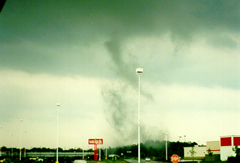
The following sequence of Midland tornado pictures were taken by Larry and Marlene Helmrecht of Kawkalin and provided to the National Weather Service Detroit/Pontiac by WNEM Channel 5 in Saginaw.
 |
 |
 |
 |
 |
 |
 |