Overview
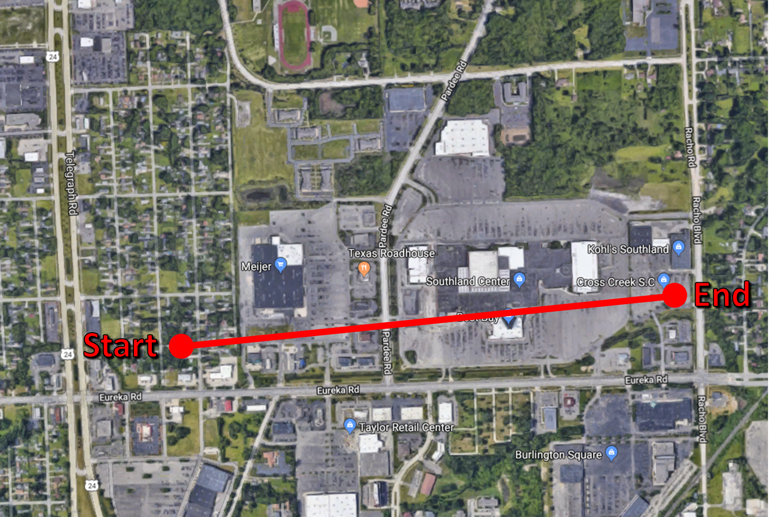
At 12:44 AM a confirmed EF-0 tornado touched down in Taylor. The tornado was on the ground for two minutes, and lifted back up at 12:46 AM. This brief tornado caused damage to three buildings and several small trees near Southland Center on Eureka Rd and Pardee Rd. Tornado damage was consistent with winds of approximately 80 MPH.
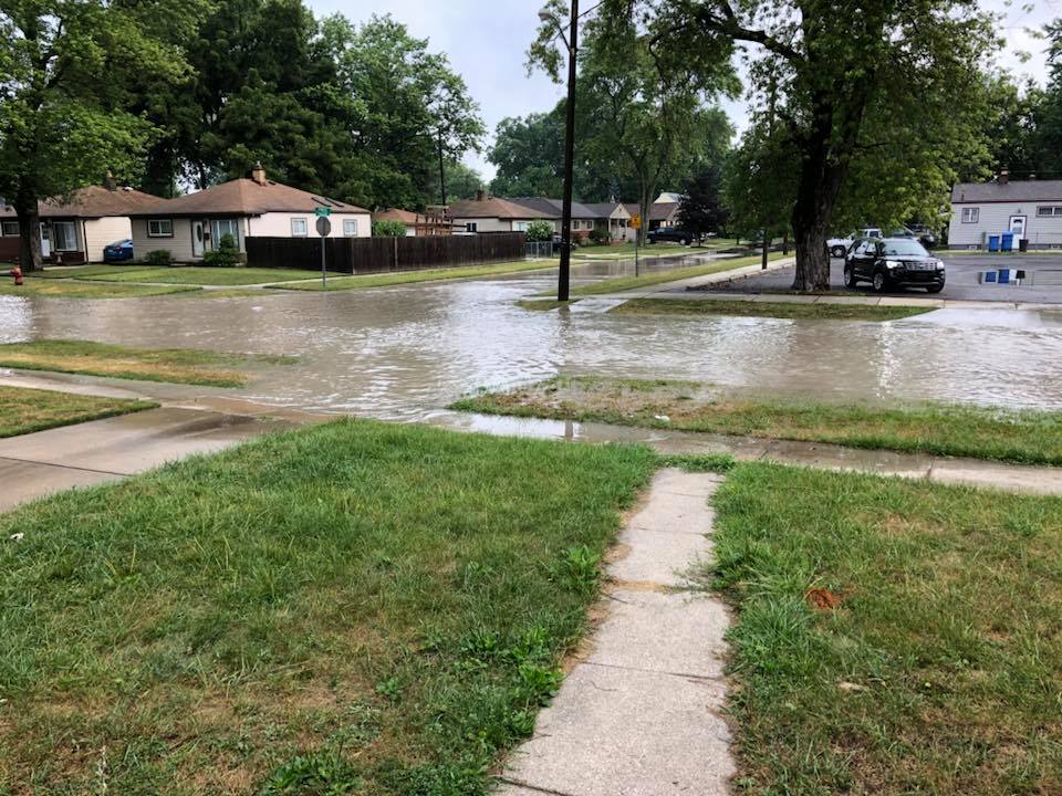
After an abnormally dry July across lower Michigan, a low pressure system lifted from the Ohio Valley over extreme southeastern Michigan and brought some much needed rainfall. Showers on the afternoon and evening of July 31 and became heavier into the nighttime hours. As the center of the low pressure interacted with the marine layer over western Lake Erie shortly after midnight, the brief tornado formed over Wayne County despite relatively weak winds aloft. Heavy rain bands and thunderstorm activity resulted in rainfall totals near 4 inches in several locations while many more areas around the Metro Detroit area received 1-3 inches, prompting a Flash Flood Warning for the urban areas as most of the rainfall occurred over a period of 3 hours or less. A couple feet of water were reported over roadways in Dearborn Heights and Taylor during the early morning hours.
Tornado Summary
|
Tornado - Taylor
Track Map
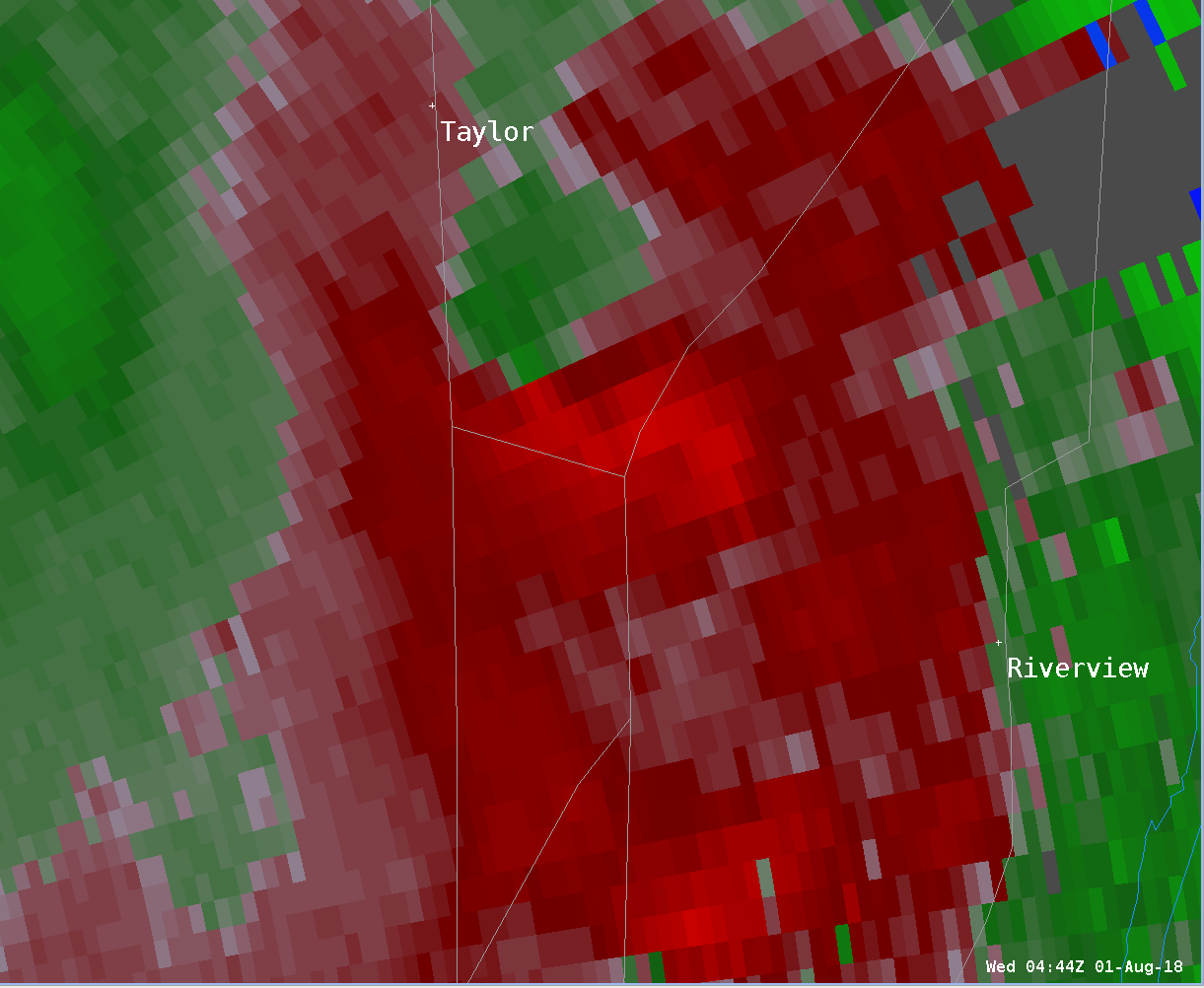
Radar Velocity Image at 12:44 AM Inbound velocities (green) located next to outbound velocities (red)
|
||||||||||||||||
The Enhanced Fujita (EF) Scale classifies tornadoes into the following categories:
| EF0 Weak 65-85 mph |
EF1 Moderate 86-110 mph |
EF2 Significant 111-135 mph |
EF3 Severe 136-165 mph |
EF4 Extreme 166-200 mph |
EF5 Catastrophic 200+ mph |
 |
|||||
Tornado Public Information Statement
Public Information Statement
National Weather Service Detroit/Pontiac MI
120 PM EDT Wed Aug 1 2018


...NWS DAMAGE SURVEY FOR 08/01/2018 TAYLOR TORNADO EVENT...


.Taylor Tornado...

Rating:                 EF-0
Estimated peak wind:    80 mph
Path length /Statute/:  0.8 miles
Path width /Maximum/:   100 yards
Fatalities:             0
Injuries:               0

Start date:             Aug 01, 2018
Start time:             12:44 AM EDT
Start location:         Taylor
Start Lat/Lon:           42.1990 / -83.2646

End date:               Aug 01, 2018
End time:               12:46 AM EDT
End location:           Taylor
End_lat/lon:             42.1998 / -83.2489

SURVEY_SUMMARY: Brief tornado caused damage to a total of 3 buildings.
Details include partial roof damage, displacement of a roof AC Unit,
damage to a business sign, and some small tree damage. Emergency
Management officials provided the details for this survey.

EF Scale: The Enhanced Fujita Scale Classifies
Tornadoes into the following categories.

EF0...Weak......65 to 85 mph
EF1...Weak......86 to 110 mph
EF2...Strong....111 to 135 mph
EF3...Strong....136 to 165 mph
EF4...Violent...166 To 200 mph
EF5...Violent...>200 mph

NOTE:
The information in this statement is PRELIMINARY and subject to
change pending final review of the event and publication in
NWS Storm Data.
Photos & Video
 |
 |
||
|
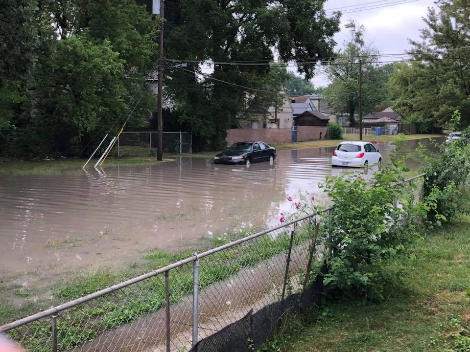
Dearborn Heights Flooding Photo Credit: Krystal Johnson |
Dearborn Heights Flooding Photo Credit: Krystal Johnson |
Additional photos coming soon. |
Additional photos coming soon. |
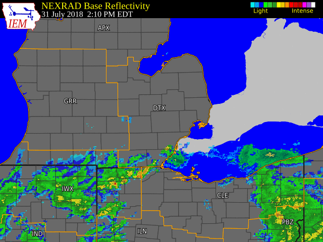
Radar
|
Click to enlarge the radar loop. |
| Radar loop courtesy of Iowa Environmental Mesonet (IEM) |
Heavy Rain Reports and Map
Public Information Statement
National Weather Service Detroit/Pontiac MI
1132 AM EDT Wed Aug 1 2018

...PRELIMINARY 24 HOUR RAINFALL REPORTS...

Location                     Amount    Time/Date       Lat/Lon

...Michigan...

...Bay County...
2 WNW Bay City               0.12 in   0700 AM 08/01   43.60N/83.93W
2 E Kawkawlin                0.11 in   0700 AM 08/01   43.66N/83.89W

...Genesee County...
Goodrich                     0.62 in   0730 AM 08/01   42.92N/83.51W
2 SE Grand Blanc             0.51 in   0700 AM 08/01   42.89N/83.59W
Linden                       0.36 in   1023 AM 08/01   42.81N/83.80W
2 W Swartz Creek             0.32 in   1019 AM 08/01   42.96N/83.88W
Flint Bishop Intl Airport    0.28 in   0753 AM 08/01   42.97N/83.74W
Flint                        0.16 in   1019 AM 08/01   43.02N/83.68W

...Huron County...
Port Hope                    0.32 in   0951 AM 08/01   44.02N/82.80W
1 WSW Bad Axe                0.15 in   1018 AM 08/01   43.80N/83.02W
Bad Axe                      0.13 in   0640 AM 08/01   43.82N/83.00W
2 ENE Ivanhoe                0.13 in   0630 AM 08/01   43.72N/83.06W
Bad Axe                      0.12 in   0830 AM 08/01   43.80N/83.00W

...Lapeer County...
2 NW Lapeer                  0.58 in   0930 AM 08/01   43.06N/83.33W
Oakdale Regional Center      0.55 in   0730 AM 08/01   43.05N/83.35W

...Lenawee County...
Lenawee County Airport       2.32 in   0753 AM 08/01   41.87N/84.08W
1 WNW Adrian                 2.27 in   1017 AM 08/01   41.91N/84.08W
Fairfield                    1.90 in   1033 AM 08/01   41.80N/84.04W
Morenci                      1.87 in   0730 AM 08/01   41.72N/84.20W
2 WNW Tipton                 1.70 in   0700 AM 08/01   42.03N/84.10W
2 NNE Adrian                 1.60 in   0800 AM 08/01   41.92N/84.02W
1 WNW Blissfield             1.48 in   0730 AM 08/01   41.84N/83.88W
Tecumseh                     1.47 in   0645 AM 08/01   42.00N/83.95W
Tecumseh                     1.43 in   0438 AM 08/01   42.02N/83.95W
1 SW Blissfield              1.06 in   0800 AM 08/01   41.83N/83.87W
1 ESE Blissfield             0.72 in   1033 AM 08/01   41.83N/83.85W

...Livingston County...
2 WNW Hamburg                0.88 in   0800 AM 08/01   42.46N/83.84W
2 E Pinckney                 0.71 in   1025 AM 08/01   42.45N/83.89W
3 NNE Chilson                0.64 in   0700 AM 08/01   42.58N/83.85W
Gm Proving Gd                0.64 in   0800 AM 08/01   42.58N/83.70W
2 ESE Howell                 0.58 in   1030 AM 08/01   42.59N/83.90W
Livingston County Airport    0.52 in   0755 AM 08/01   42.63N/83.98W
3 WNW Pinckney               0.49 in   1025 AM 08/01   42.48N/84.00W
1 SE Argentine               0.48 in   0800 AM 08/01   42.77N/83.82W
1 S Argentine                0.43 in   0700 AM 08/01   42.77N/83.83W
Howell                       0.40 in   1035 AM 08/01   42.60N/83.94W
3 WSW Howell                 0.37 in   1035 AM 08/01   42.59N/84.00W
1 SE Gregory                 0.37 in   1035 AM 08/01   42.45N/84.07W
Brighton                     0.35 in   1030 AM 08/01   42.53N/83.80W

...Macomb County...
2 WNW Utica                  2.34 in   0606 AM 08/01   42.64N/83.07W
Richmond 4 NNW               2.03 in   0807 AM 08/01   42.88N/82.80W
1 WNW Sterling Heights       1.51 in   1006 AM 08/01   42.59N/83.06W
2 NNW Utica                  1.47 in   0700 AM 08/01   42.67N/83.03W
1 N Fraser                   1.36 in   0700 AM 08/01   42.56N/82.95W
2 WSW Sterling Heights       1.35 in   1033 AM 08/01   42.57N/83.08W
5 NW Mt Clemons              1.32 in   0700 AM 08/01   42.60N/82.82W
2 E Utica                    1.25 in   0700 AM 08/01   42.64N/82.97W
1 NNW Saint Clair Shores     1.24 in   0500 AM 08/01   42.51N/82.90W
2 WNW Mount Clemens          1.20 in   0700 AM 08/01   42.62N/82.92W
2 NNE Saint Clair Shores     0.97 in   1026 AM 08/01   42.52N/82.88W
New Baltimore                0.86 in   0800 AM 08/01   42.68N/82.74W

...Midland County...
1 SW Poseyville              0.05 in   0800 AM 08/01   43.51N/84.27W
2 SW Midland                 0.04 in   0700 AM 08/01   43.59N/84.27W
Oil City 3e                  0.03 in   0730 AM 08/01   43.61N/84.53W
1 NNE Midland                0.03 in   0600 AM 08/01   43.64N/84.22W

...Monroe County...
2 S Carleton                 2.31 in   0800 AM 08/01   42.02N/83.39W
Milan Wwtp                   2.00 in   0920 AM 08/01   42.08N/83.68W
Monroe                       1.99 in   0757 AM 08/01   41.94N/83.45W
Monroe Wwtp                  1.92 in   0900 AM 08/01   41.90N/83.37W
Ida                          1.84 in   1020 AM 08/01   41.91N/83.57W
1 SSW Cone                   1.49 in   0800 AM 08/01   42.01N/83.77W
3 S Monroe                   1.28 in   0700 AM 08/01   41.87N/83.38W
Dundee                       1.15 in   0530 AM 08/01   41.95N/83.65W
2 E Dundee                   1.10 in   1016 AM 08/01   41.96N/83.62W
1 S South Rockwood           0.96 in   0900 AM 08/01   42.03N/83.26W
Stony Point                  0.84 in   0700 AM 08/01   41.95N/83.28W
Newport 4sse                 0.84 in   0700 AM 08/01   41.95N/83.28W

...Oakland County...
2 NNW Southfield             3.52 in   1019 AM 08/01   42.52N/83.27W
2 ENE Northville             2.68 in   1022 AM 08/01   42.45N/83.45W
Troy                         2.45 in   0200 AM 08/01   42.58N/83.14W
1 W Orchard Lake             2.44 in   1026 AM 08/01   42.58N/83.41W
4 NE Novi                    2.28 in   0800 AM 08/01   42.52N/83.43W
Orchard Lake                 2.10 in   0800 AM 08/01   42.58N/83.39W
2 SW Birmingham              1.79 in   0800 AM 08/01   42.51N/83.24W
1 S Troy                     1.73 in   0815 AM 08/01   42.55N/83.14W
Ferndale                     1.61 in   1033 AM 08/01   42.46N/83.13W
Farmington                   1.58 in   0730 AM 08/01   42.47N/83.37W
3 N Farmington               1.55 in   0700 AM 08/01   42.51N/83.38W
3 ESE Orchard Lake           1.50 in   0700 AM 08/01   42.55N/83.32W
2 S Orchard Lake             1.40 in   1033 AM 08/01   42.54N/83.38W
4 NNW Novi                   1.40 in   0630 AM 08/01   42.54N/83.52W
Oakland County International 1.38 in   0753 AM 08/01   42.66N/83.42W
1 NE Clarkston               1.34 in   0700 AM 08/01   42.75N/83.40W
1 S Royal Oak                1.25 in   0700 AM 08/01   42.49N/83.16W
4 E White Lake               1.09 in   0800 AM 08/01   42.70N/83.47W
2 NW Waterford               1.07 in   0700 AM 08/01   42.69N/83.41W
4 S White Lake               1.00 in   1035 AM 08/01   42.59N/83.51W
Lake Orion 4.3 SSE           0.98 in   0700 AM 08/01   42.72N/83.23W
1 W Leonard                  0.92 in   1026 AM 08/01   42.87N/83.17W
1 N Waterford                0.90 in   1021 AM 08/01   42.68N/83.39W
2 S Ortonville               0.86 in   0800 AM 08/01   42.82N/83.44W
Oxford                       0.80 in   1026 AM 08/01   42.82N/83.25W
2 SE Ortonville              0.76 in   1023 AM 08/01   42.83N/83.42W
2 SSW Ortonville             0.75 in   1026 AM 08/01   42.82N/83.46W
1 ESE Davisburg              0.68 in   0800 AM 08/01   42.74N/83.52W
2 SE Fenton                  0.51 in   0800 AM 08/01   42.77N/83.69W
2 ENE Fenton                 0.23 in   1001 AM 08/01   42.82N/83.68W

...Saginaw County...
Saginaw                      0.11 in   1033 AM 08/01   43.43N/83.95W
2 NE Chesaning               0.10 in   0630 AM 08/01   43.22N/84.10W
Shields                      0.09 in   0900 AM 08/01   43.42N/84.08W
3 ENE Shields                0.08 in   1021 AM 08/01   43.44N/84.02W
Mbs International Airport    0.07 in   0753 AM 08/01   43.53N/84.08W

...Sanilac County...
Lexington Water Plant        1.05 in   0630 AM 08/01   43.26N/82.53W
Melvin                       0.62 in   1030 AM 08/01   43.18N/82.86W
Brown City                   0.59 in   1033 AM 08/01   43.21N/82.98W

...Shiawassee County...
Corunna 2 NE                 0.53 in   0600 AM 08/01   43.00N/84.07W
Durand Wwtp                  0.24 in   0800 AM 08/01   42.93N/83.99W
3 SSE Corunna                0.19 in   0800 AM 08/01   42.93N/84.10W
2 W Bennington               0.16 in   1016 AM 08/01   42.94N/84.30W
5 SSW Owosso                 0.16 in   0700 AM 08/01   42.97N/84.20W

...St. Clair County...
Port Huron                   2.32 in   1021 AM 08/01   43.00N/82.44W
1 W Port Huron               2.08 in   0815 AM 08/01   43.00N/82.46W
2 W Port Huron               2.04 in   1015 AM 08/01   43.00N/82.48W
2 S Port Huron               1.38 in   0800 AM 08/01   42.96N/82.43W
1 NNE Port Huron             1.35 in   1030 AM 08/01   43.01N/82.42W
1 NNE Yale                   0.78 in   0635 AM 08/01   43.15N/82.80W
1 N Capac                    0.60 in   1021 AM 08/01   43.03N/82.93W

...Tuscola County...
Regional Center              0.14 in   0720 AM 08/01   43.45N/83.40W
Vassar                       0.13 in   0700 AM 08/01   43.37N/83.58W

...Washtenaw County...
3 SE Ann Arbor               2.06 in   8000 AM 08/01   42.24N/83.69W
4 NW Ypsilanti               1.99 in   1026 AM 08/01   42.30N/83.66W
4 SW Saline                  1.91 in   0800 AM 08/01   42.13N/83.82W
Ann Arbor Se                 1.84 in   0730 AM 08/01   42.24N/83.69W
3 SSW Saline                 1.80 in   0700 AM 08/01   42.13N/83.81W
2 W Saline                   1.70 in   1028 AM 08/01   42.18N/83.83W
1 ENE Ypsilanti              1.62 in   1023 AM 08/01   42.26N/83.59W
2 SE Dexter                  1.53 in   0700 AM 08/01   42.30N/83.86W
1 ENE Ypsilanti              1.49 in   0700 AM 08/01   42.25N/83.60W
2 W Ann Arbor                1.45 in   0800 AM 08/01   42.28N/83.77W
1 SSE Salem                  1.40 in   0700 AM 08/01   42.38N/83.57W
1 SE Saline                  1.33 in   0700 AM 08/01   42.16N/83.77W
2 E Ypsilanti                1.25 in   0700 AM 08/01   42.24N/83.58W
2 WSW Manchester             1.15 in   1034 AM 08/01   42.13N/84.08W
2 N Ann Arbor                1.13 in   1031 AM 08/01   42.31N/83.73W
Manchester                   1.09 in   0646 AM 08/01   42.15N/84.02W
1 WSW Manchester             1.05 in   1034 AM 08/01   42.14N/84.07W
Dexter                       1.05 in   0700 AM 08/01   42.34N/83.89W
3 SE Ann Arbor               0.98 in   0700 AM 08/01   42.24N/83.70W
2 SSW Chelsea                0.77 in   0800 AM 08/01   42.28N/84.03W
1 NE Chelsea                 0.73 in   0930 AM 08/01   42.32N/84.02W
1 W Ann Arbor                0.66 in   1026 AM 08/01   42.28N/83.77W

...Wayne County...
Dearborn Heights             3.25 in   0700 AM 08/01   42.33N/83.27W
2 WSW Dearborn               3.08 in   0700 AM 08/01   42.29N/83.26W
Detroit Metropolitan         3.00 in   0753 AM 08/01   42.21N/83.35W
2 NNW Flat Rock              2.96 in   0730 AM 08/01   42.13N/83.29W
3 S Redford                  2.75 in   0400 AM 08/01   42.34N/83.30W
Livonia 2.2 WNW              2.67 in   0635 AM 08/01   42.41N/83.41W
1 E Taylor                   2.58 in   1021 AM 08/01   42.23N/83.23W
2 SSE Southwest Detroit      2.56 in   1019 AM 08/01   42.30N/83.10W
2 NNE Flat Rock              2.50 in   0600 AM 08/01   42.14N/83.25W
1 NE Livonia                 2.11 in   0700 AM 08/01   42.42N/83.34W
1 SSW Plymouth               1.95 in   0700 AM 08/01   42.35N/83.47W
Downtown Detroit             1.88 in   1020 AM 08/01   42.34N/83.05W
Dearborn No.2                1.85 in   0400 AM 08/01   42.35N/83.17W
3 WNW Southwest Detroit      1.85 in   0400 AM 08/01   42.35N/83.17W
1 SW Westland                1.50 in   1019 AM 08/01   42.30N/83.40W
2 W Livonia                  1.41 in   1035 AM 08/01   42.41N/83.43W
Detroit City Airport         1.39 in   0753 AM 08/01   42.41N/83.01W
1 N Grosse Ile               1.35 in   0729 AM 08/01   42.15N/83.15W
Willow Run Airport           1.25 in   0753 AM 08/01   42.24N/83.53W
Wyandotte                    1.20 in   0800 AM 08/01   42.20N/83.17W
Flat Rock                    1.03 in   0643 AM 08/01   42.11N/83.28W

Observations are collected from a variety of sources with varying equipment
and exposures. All data is preliminary and has not undergone final quality
control by the National Climatic Data Center / NCDC/. Therefore...this data
may be subject to revision. We thank all volunteer weather observers for
their dedication. Not all data listed are considered official. Final and
certified climate data can be accessed at www.ncdc.noaa.gov
 |
|
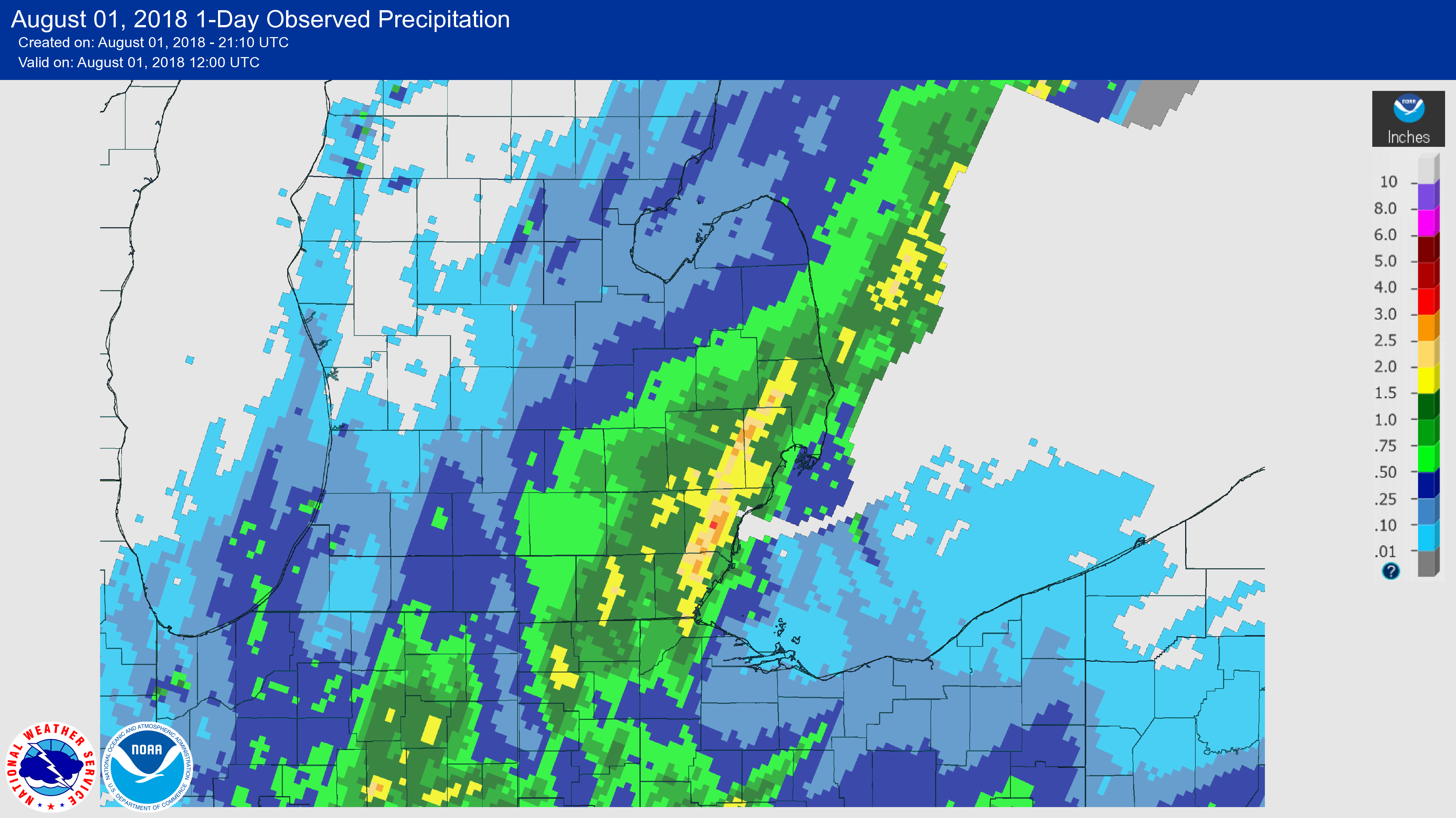
24-hour Quantitative Precipitation Estimate (QPE) |
 |
Media use of NWS Web News Stories is encouraged! Please acknowledge the NWS as the source of any news information accessed from this site. |
|