Overview
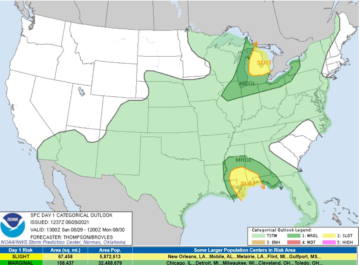
A warm and muggy day characterized by temperatures in the upper 80s to lower 90s and dewpoints in the lower 70s set the stage for severe weather potential on Sunday afternoon and evening, highlighted by SPC's Day 1 Severe Weather Outlook, where Michigan resided under a Marginal/Slight risk. A cold front produced a line of strong to severe thunderstorms that moved across SE MI between 4-8 PM EDT. Wind gusts between 40-50 mph, isolated to 60 mph, were observed with stronger activity. This resulted in isolated reports of downed trees and powerlines. A Severe Thunderstorm Watch was issued prior to the arrival of the cold front for counties north of I94.
Radar
.gif)  |
|
Click to Enlarge Radar loop courtesy of Iowa Environmental Mesonet (IEM) |
Storm Reports
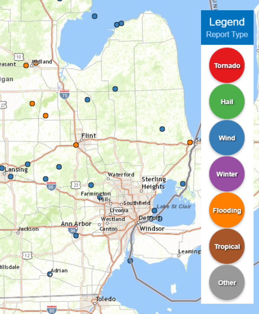 |
|
Map of Local Storm Reports |
PRELIMINARY LOCAL STORM REPORT...SUMMARY
NATIONAL WEATHER SERVICE DETROIT/PONTIAC MI
951 AM EDT MON AUG 30 2021

..TIME...   ...EVENT...      ...CITY LOCATION...     ...LAT.LON...
..DATE...   ....MAG....      ..COUNTY LOCATION..ST.. ...SOURCE....
            ..REMARKS..

0450 PM     MARINE TSTM WIND 8 ESE AU GRES           44.02N 83.54W
08/29/2021  M41.00 MPH       LHZ421             MI   BUOY

            A MARINE THUNDERSTORM WIND GUST OF 41 MPH, 36 KNOTS,
            MEASURED AT GRAVELLY SHOAL LIGHT.

0504 PM     MARINE TSTM WIND 1 NW CASEVILLE          43.95N 83.29W
08/29/2021  M51.00 MPH       LHZ421             MI   MESONET

            A MARINE THUNDERSTORM WIND GUST OF 51 MPH, 44 KNOTS,
            MEASURED AT CASEVILLE LIGHT.

0510 PM     TSTM WND DMG     2 ENE CASEVILLE         43.96N 83.24W
08/29/2021                   HURON              MI   PUBLIC

            TREES DOWN. TIME ESTIMATED FROM RADAR.

0520 PM     TSTM WND DMG     3 WSW PERRY             42.81N 84.29W
08/29/2021                   SHIAWASSEE         MI   911 CALL CENTER

            TREES DOWN. TIME ESTIMATED BY RADAR.

0532 PM     TSTM WND DMG     3 SW VASSAR             43.34N 83.62W
08/29/2021                   TUSCOLA            MI   911 CALL CENTER

            TREES AND WIRES REPORTED DOWN ALONG PINKERTON ROAD. TIME
            ESTIMATED BASED ON RADAR.

0533 PM     TSTM WND DMG     2 S BYRON               42.79N 83.94W
08/29/2021                   SHIAWASSEE         MI   911 CALL CENTER

            TREES DOWN INCLUDING A TREE DOWN ON A VEHICLE. TIME
            ESTIMATED BY RADAR.

0537 PM     TSTM WND DMG     2 NNW FOWLERVILLE       42.69N 84.09W
08/29/2021                   LIVINGSTON         MI   FIRE DEPT/RESCUE

            A COUPLE LARGE TREES DOWN OVER THE ROAD NEAR THE
            INTERSECTION OF GREGORY ROAD AND ALLEN ROAD.

0601 PM     TSTM WND DMG     2 NW EAST DAYTON        43.43N 83.31W
08/29/2021                   TUSCOLA            MI   911 CALL CENTER

            TREES DOWN OVER THE ROAD NEAR THE INTERSECTION OF M-46
            AND PHILLIPS ROAD.

0636 PM     TSTM WND DMG     4 NNE MILFORD           42.64N 83.58W
08/29/2021                   OAKLAND            MI   911 CALL CENTER

            SEVERAL TREES REPORTED DOWN ACROSS MILFORD AND HIGHLAND
            TWP VIA CENTRAL DISPATCH.

0647 PM     TSTM WND DMG     WALLED LAKE             42.54N 83.48W
08/29/2021                   OAKLAND            MI   911 CALL CENTER

            TREE DAMAGE REPORTED VIA CENTRAL DISPATCH.

0649 PM     TSTM WND GST     4 SSW ANN ARBOR         42.22N 83.75W
08/29/2021  M52.00 MPH       WASHTENAW          MI   ASOS

            ANN ARBOR ASOS MEASURED 52 MPH WIND GUST.

0708 PM     TSTM WND DMG     2 SSE YALE              43.10N 82.78W
08/29/2021                   ST. CLAIR          MI   TRAINED SPOTTER

            MULTIPLE TREES DOWN. TIME ESTIMATED BY RADAR.

0709 PM     TSTM WND DMG     ADRIAN                  41.90N 84.04W
08/29/2021                   LENAWEE            MI   FIRE DEPT/RESCUE

            TREE SNAPPED CAUSING POWER OUTAGES IN THE CITY OF ADRIAN
            NEAR MILES AND DIVISION ST.

0759 PM     TSTM WND DMG     2 NNW ALGONAC           42.65N 82.55W
08/29/2021                   ST. CLAIR          MI   PUBLIC

            TREE DOWN NEAR MARSH RD AND HIGH RD IN CLAY TWP.

0810 PM     MARINE TSTM WIND 2 S GROSSE POINTE       42.36N 82.91W
08/29/2021  M41.00 MPH       LCZ460             MI   MESONET

            A MARINE THUNDERSTORM WIND GUST OF 41 MPH, 36 KNOTS,
            MEASURED AT PECHE ISLAND LIGHT. CORRECTED LOCATION.

0814 PM     MARINE TSTM WIND 4 NNE GROSSE POINTE     42.43N 82.87W
08/29/2021  M47.00 MPH       LCZ460             MI   MESONET

            A MARINE THUNDERSTORM WIND GUST OF 47 MPH, 41 KNOTS,
            MEASURED AT GROSSE POINTE YACHT CLUB.

0817 PM     MARINE TSTM WIND 5 ENE ESTRAL BEACH      42.01N 83.14W
08/29/2021  M53.00 MPH       LEZ444             MI   C-MAN STATION

            A MARINE THUNDERSTORM WIND GUST OF 53 MPH, 46 KNOTS,
            MEASURED AT THE DETROIT RIVER LIGHT
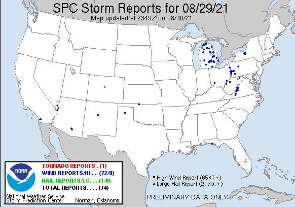 |
|
National Storm Reports for August 29, 2021 |
Environment
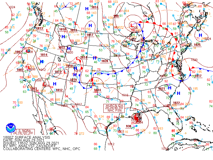
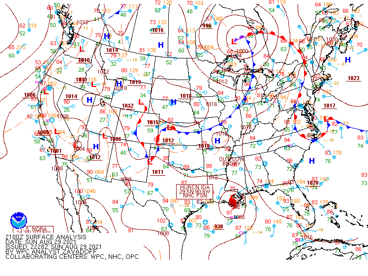
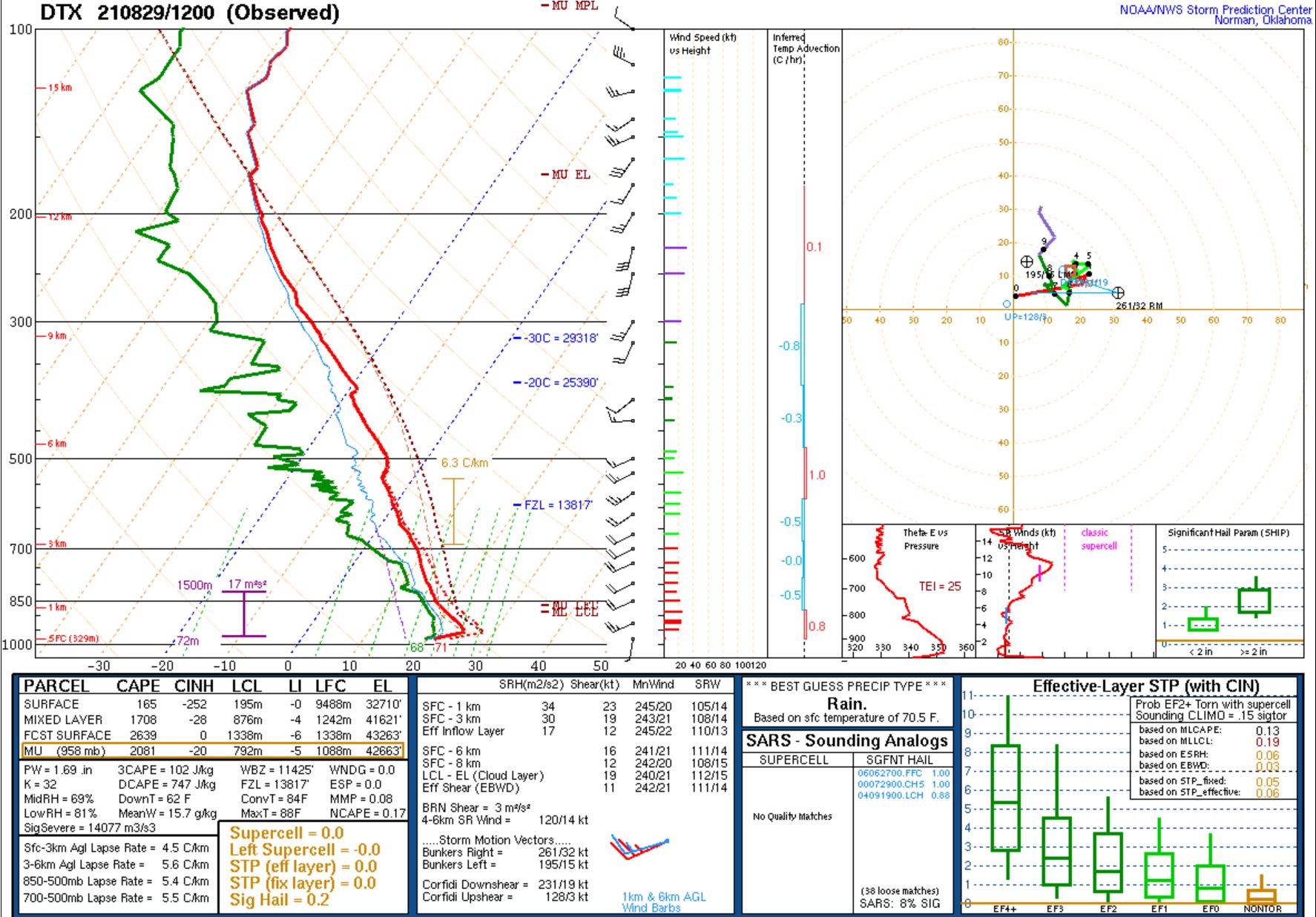
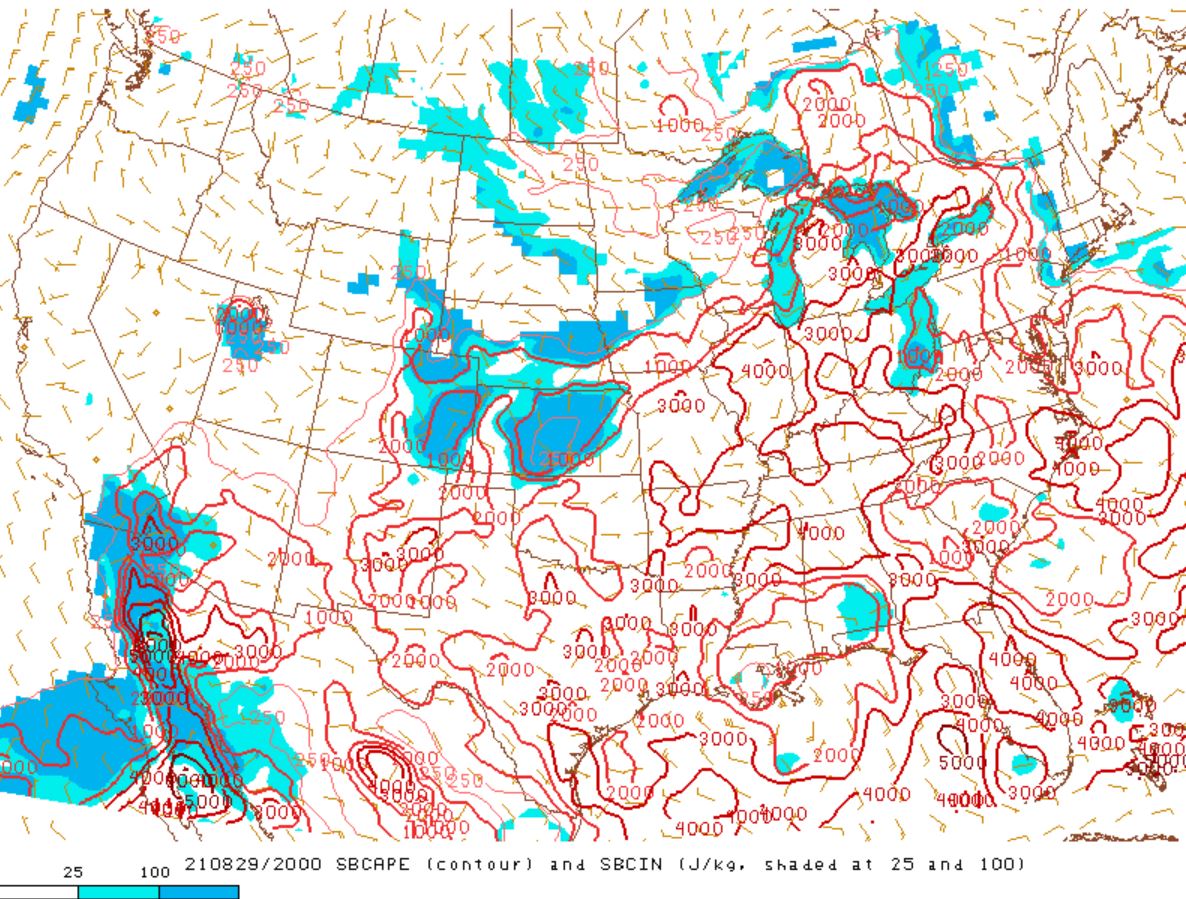
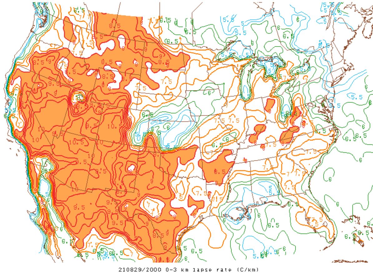
A cold front produced a line of strong showers and thunderstorms across SE MI between the hours of 20Z Sun to 00Z Mon (Figures 1-3). A subtropical airmass was in place across Michigan prior to the passage of the front, where afternoon temperatures peaked in the upper 80s to lower 90s, with dew points in the lower 70s (Figure 6). Humid conditions along with sufficient daytime heating resulted in SBCAPE values reaching to or above 3,000 J/kg (Figure 7) prior to the passage of the front. Low-level lapse rates nearing 7 C/km (Figure 8) and DCAPE values in excess of 1,000 J/kg (Figure 9), along with precipitation loading, aided in the production of strong to severe wind gusts. Isolated wind damage reports were received across portions of SE MI as a result, mainly in the form of downed trees and powerlines.
Click on the images below to see them expanded.
 |
 |
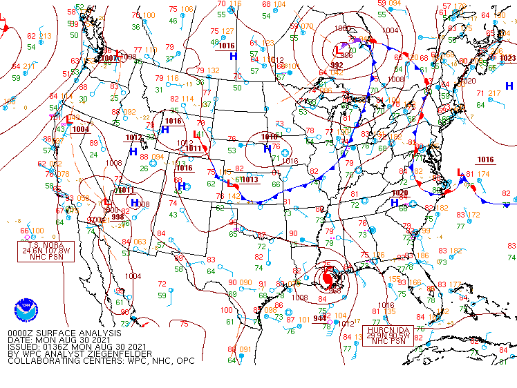 |
| Figure 1: Weather Prediction Center (WPC) surface map, valid 18 UTC 29 Aug 2021. | Figure 2: Weather Prediction Center (WPC) surface map, valid 21 UTC 29 Aug 2021. | Figure 3: Weather Prediction Center (WPC) surface map, valid 00 UTC 29 Aug 2021. |
 |
 |
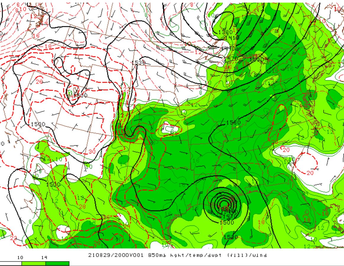 |
| Figure 4: KDTX observed sounding, valid 12 UTC 29 Aug 2021. | Figure 5: SPC Day 1 Outlook, valid 13 UTC 29 Aug 2021. | Figure 6: 850 mb height, temperature & dew point, valid 20 UTC 29 Aug 2021. |
 |
 |
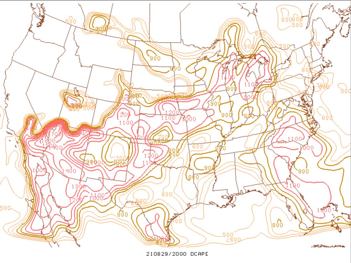 |
| Figure 7: SBCAPE, valid 20 UTC 29 Aug 2021. | Figure 8: 0-3 km lapse rate, valid 20 UTC 29 Aug 2021 | Figure 9: DCAPE, valid 20 UTC 29 Aug 2021 |
 |
Media use of NWS Web News Stories is encouraged! Please acknowledge the NWS as the source of any news information accessed from this site. |
|

